
Al-Hijr Archaeological Site (Hegra; also known by the Arabic name “Mada’in Salih” — “مدائن صالح” — “the cities of Salih”, referring to the Prophet Salih of the Islamic tradition who is said to have preached to the ancient Thamudic people of the Hejaz; the Nabataean name for the city was “Hegra” — from the Aramaic/Nabataean root possibly meaning “walled city” or “enclosed city”; the modern UNESCO-preferred name is “Al-Hijr Archaeological Site [Madâin Sâlih]”), inscribed by UNESCO in 2008 as Saudi Arabia’s first World Heritage Site, is a UNESCO World Heritage designation that recognises the largest conserved site of the Nabataean civilisation in the world south of Petra — a monumental complex of approximately 111 decorated rock-cut tomb facades and approximately 2,000 undecorated tomb chambers carved from the golden-yellow sandstone outcrops of the Al-‘Ula Valley in the Medina Region of northwestern Saudi Arabia (approximately 500 km north of Medina, approximately 1,400 km from Riyadh, and approximately 320 km south of Petra in Jordan — the distance between Petra and Hegra along the ancient Incense Road being approximately a month’s camel journey). The site (the inscribed area covers approximately 1,621 hectares and includes the monumental necropolis of rock-cut tombs, the remains of the Nabataean urban settlement, the Hijaz Railway station complex built by the Ottoman Empire approximately 1907 CE, and extensive evidence of earlier occupation including Lihyanite and Dedanite inscriptions and pre-Nabataean agricultural installations) represents the southern extension of the Nabataean Kingdom’s commercial and political power — the southernmost major Nabataean urban centre in the ancient world, and the most southerly point at which the fully developed Nabataean rock-cut architectural style (perfected at Petra in the 1st century BCE–1st century CE) was applied to monumental funerary monuments.
The Nabataean tomb facades of Hegra and the ancient Incense Road Tomb Facades · Incense Road · Hejaz Railway · Al-‘Ula Old Town 22 km · Medina 500 km · Petra 320 km (Jordan)
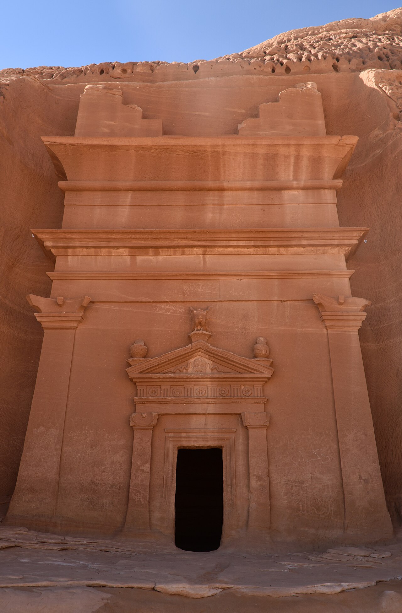
The Nabataean tomb facades of Hegra (the most spectacular of which are approximately 15–25 m tall, carved from the vertical cliff faces of isolated sandstone outcrops — “jebels” in Arabic — that rise from the flat gravel floor of the Al-‘Ula Valley) share the basic architectural vocabulary of the Petra tomb facades: a two-register facade with classical Hellenistic architectural elements (pediments, pilasters, Doric and Nabataean Corinthian capitals) carved in relief on the sandstone cliff face, with a burial chamber (approximately 2–6 m deep, with niches cut into the walls for the bodies of the deceased and their goods) excavated into the rock behind the facade. The Hegra tombs differ from the Petra tombs in several important respects: (1) most of them bear dedicatory inscriptions in the Nabataean script (the Aramaic-derived script that is the ancestor of the Arabic script) carved directly onto the facade, recording the name of the tomb’s owner, their family, their religious status, and (crucially) the date of the tomb’s construction — the dated Hegra inscriptions provide one of the most precise chronological anchors for Nabataean archaeology, with the inscriptions ranging from approximately 1 CE to approximately 75 CE (the decades immediately before and after the Roman annexation of the Nabataean Kingdom as the Province of Arabia Petraea in 106 CE); (2) the Hegra tombs preserve the facade decoration in better condition than most Petra tombs due to the drier microclimate of the Al-‘Ula Valley, which has experienced very limited rainfall in historical time — the carved reliefs and the inscriptions at Hegra are sharper and better-preserved than most Petra equivalents; (3) the scale of the Hegra complex (approximately 111 decorated tomb facades grouped in several distinct “jebel” clusters across the site) demonstrates that Hegra was a major Nabataean city in its own right, not simply a remote outpost — the population of Nabataean Hegra at its peak (approximately 1st century CE) may have been approximately 5,000–10,000 people, significantly smaller than Petra but substantial for the desert environment. The strategic importance of Hegra for the Nabataean Kingdom derived from its position on the ancient “Incense Road” — the overland trade route connecting the incense-producing regions of southern Arabia (modern Yemen and Oman) with the Mediterranean markets of the Levant and Egypt. Hegra controlled the northern Hejaz section of this route, approximately halfway between the southern Arabian incense sources and the Nabataean capital of Petra — a position that allowed the Nabataean merchants based at Hegra to extract tolls from and provide services (water, food, accommodation) to the camel caravans traversing the route. The role of Hegra as a way-station on the incense route is documented both in the ancient Greek and Roman literary sources (Pliny the Elder’s “Natural History” describes the Nabataean route in detail) and in the archaeological evidence of the site (the extensive water management infrastructure — cisterns, channels, and wells — that enabled the caravans to water their animals in the desert environment, and the evidence of commercial accommodation and warehousing in the urban area of the site).
Practical information
Hegra is located near the modern town of Al-‘Ula (approximately 22 km from the site entrance), which has been developed as a major heritage tourism destination by the Saudi government’s Royal Commission for AlUla (RCU) as part of the Vision 2030 tourism development programme. The Al-‘Ula area is served by AlUla Regional Airport (with direct connections to Riyadh, Jeddah, and several other Saudi cities, and increasingly to international destinations). The Hegra archaeological site is open to visitors with a guided tour (tours are mandatory — the site is not accessible independently) organised through the RCU’s “AlUla” tourism platform; ticket prices and tour schedules change seasonally. The site visit includes the major tomb clusters (the “Qasr al-Bint”, “Qasr al-Farid”, “Diwan”, and “Siq” clusters), with a vehicle-based circuit around the main rock outcrops. The “Qasr al-Farid” (“the lonely castle”) — the largest single tomb facade at Hegra, approximately 22 m tall, which stands in isolation on a single rock outcrop in the middle of the valley and was never finished (only the upper two-thirds of the facade decoration were completed, the lower third remaining as bare rock — a fact of great value for archaeologists, as it documents the carving sequence: the Nabataean tomb carvers worked from top to bottom, finishing the cornice and upper elements before carving the lower registers) — is the site’s most photographed monument. Best visiting months: November–March (the Al-‘Ula Valley temperature exceeds 40°C in summer; winter temperatures are pleasant at 15–25°C).
Frequently Asked Questions
What is the Incense Road and why was it one of the most important trade routes in the ancient world?
The Incense Road (also called the “Incense Route”, “Spice Route”, or “Frankincense Route” — the trade route system connecting the incense-producing regions of southern Arabia and the Horn of Africa with the markets of the Mediterranean, Mesopotamia, and India, in active use from approximately the 10th century BCE to approximately the 1st–2nd century CE, when the development of reliable monsoon-wind navigation of the Indian Ocean by Greek and Roman sailors gradually shifted the trade from overland to maritime routes) was one of the most economically significant trade corridors in the ancient world precisely because it transported substances — frankincense (from the Boswellia sacra tree, growing primarily in the Dhofar region of modern Oman and in northern Somalia and Ethiopia) and myrrh (from the Commiphora myrrha tree, growing in the same southern Arabian and East African regions) — that were absolutely essential for the religious practices of virtually every Mediterranean and Near Eastern civilisation of the period. Frankincense (Latin “thus” or “olibanum” — the dried resin of Boswellia trees, which produces a fragrant smoke when burned, used for approximately 5,000 years in religious ceremonies as an offering and a purification agent) was consumed in prodigious quantities: the Roman Empire alone imported an estimated 2,800 tonnes of frankincense per year (at approximately the equivalent of €10–20 per kg in modern purchasing-power terms — this is not a precise calculation but gives an order of magnitude); the burning of frankincense in temples and religious ceremonies throughout the Mediterranean (in Egyptian, Greek, Roman, Jewish, and Christian contexts) was so universal that the demand for the substance — growing only in a small geographic area of southern Arabia — sustained a long-distance trade network for over a millennium. The overland route from the Dhofar frankincense groves to the Mediterranean markets traversed: the southern Arabian coastal zone (approximately 1,500 km from Dhofar to modern Yemen), then northward through the Hejaz (the western coastal strip of the Arabian Peninsula — the modern Saudi provinces of Mecca and Medina) via a series of oasis towns (the most important of which were Najran [a large oasis approximately 800 km north of the Dhofar coast], Ma’an [approximately 1,000 km further north, in modern Jordan], and Petra [the Nabataean capital and the northern terminus of the Hejaz section of the route]) to the Mediterranean ports of Gaza and Alexandria. The total length of the overland Incense Road from Dhofar to Gaza was approximately 3,000 km, traversed by camel caravan at a rate of approximately 30–40 km per day (camel caravans typically covered approximately 25–30 km per day loaded, faster when unladen; the camels required water approximately every 3–5 days in the desert conditions), meaning the full journey took approximately 60–100 days. The Nabataean Kingdom owed its wealth and power primarily to its control of the northern Hejaz section of this route — the section between Hegra and Petra and then to Gaza — and to its expertise in desert water management (the cisterns, channels, and wells that allowed the caravans to cross the otherwise waterless desert zones). The collapse of the overland Incense Road trade in the 1st–3rd century CE was a direct consequence of the development of reliable monsoon navigation of the Red Sea and the Indian Ocean by Greek and Roman sailors (documented in the “Periplus of the Erythraean Sea”, approximately 50 CE) — which allowed Roman merchants to sail directly from Red Sea ports to the frankincense-producing coasts of Arabia and East Africa, bypassing the overland Nabataean-controlled route entirely. This maritime route shift is the primary explanation for the Nabataean Kingdom’s gradual economic decline in the 1st century CE and for the ease with which the Roman Emperor Trajan was able to annex the Kingdom as the Province of Arabia Petraea in 106 CE without significant resistance.
What is the Hejaz Railway and what happened to it?
The Hejaz Railway (Arabic: “سكة حديد الحجاز”, “Sikkat Hadid al-Hijaz”) was a narrow-gauge (1050 mm) steam railway built between 1900 and 1908 CE by the Ottoman Sultan Abdulhamid II, connecting Damascus (the Ottoman administrative capital of Syria) to Medina (the second holiest city in Islam, and the terminus of the pilgrimage for those unable to reach Mecca) — a total length of approximately 1,320 km, traversing the length of the Hejaz (the western Arabian Peninsula coast) through Jordan and northwestern Saudi Arabia. The railway was built primarily with funds raised from voluntary contributions from Muslim communities worldwide (Abdulhamid II presented the project as a pan-Islamic endeavour to ease the hajj pilgrimage and to assert Ottoman sovereignty over the holy cities) and with Ottoman state funds, using primarily Egyptian and Syrian labourers and European (mostly Italian and German) engineers and equipment. The Hegra (Mada’in Salih) section of the railway (built approximately 1906–1908 CE) is particularly significant archaeologically because the Ottoman railway construction team built a complete station complex at Hegra — a multi-building station with accommodation for pilgrims, a water tower, locomotive maintenance facilities, and a telegraph station — directly adjacent to the Nabataean archaeological site, using the same local yellow sandstone as the ancient Nabataean tombs and creating an unwitting continuity between the ancient trade route (the Incense Road) and the modern pilgrimage transport (the railway). The Hejaz Railway operated successfully as a pilgrimage route and military supply line from approximately 1908 until the Arab Revolt of 1916–1918 CE, during which T.E. Lawrence and the Arab forces systematically attacked and destroyed sections of the railway to disrupt Ottoman military logistics (the “railway raiding” campaign that Lawrence described vividly in “Seven Pillars of Wisdom”). After the Arab Revolt, the northern section of the railway (Damascus to Medina) was partially repaired but never fully restored, and the section from Medina southward (including the Hegra station) was abandoned — the locomotive, wagons, and equipment were gradually dismantled for scrap during the World War II period, and the section from Ma’an to Medina (including Hegra) has remained out of service since approximately 1917 CE. The Ottoman-period Hegra station and its associated buildings are now preserved within the UNESCO World Heritage Site as an important layer of the site’s multi-period history — the contrast between the 2,000-year-old Nabataean tomb facades and the 115-year-old Ottoman railway station embodying the long history of the Al-‘Ula valley as a transit point on successive trade and pilgrimage routes.
EXCERPT: Al-Hijr Archaeological Site (Hegra / Mada’in Salih), Saudi Arabia, UNESCO-inscribed 2008 — Saudi Arabia’s first World Heritage Site: 111 Nabataean rock-cut tomb facades with dated inscriptions (1–75 CE), the Incense Road way-station linking Dhofar’s frankincense groves to the Mediterranean, and the abandoned Ottoman Hejaz Railway station — built for the pilgrim route that T.E. Lawrence’s Arab Revolt later destroyed in 1917.
META: UNESCO World Heritage Sites near Hegra Saudi Arabia: Petra Jordan 320 km north (UNESCO 1985), Rock Art Hail Region Saudi Arabia (UNESCO 2015), Al-Ahsa Oasis Saudi Arabia (UNESCO 2018) — Al-Hijr Hegra Mada’in Salih Saudi Arabia UNESCO 2008, Nabataean rock-cut tombs incense road, Qasr al-Farid unfinished tomb facade, Hejaz Railway pilgrimage Ottoman T.E. Lawrence, frankincense myrrh ancient trade routes Arabia.
Sources
- S1 — UNESCO World Heritage Centre — Al-Hijr Archaeological Site (Madâin Sâlih) (Ref. 1293) — https://web.archive.org/web/20230601000000/https://whc.unesco.org/en/list/1293/
- S2 — Royal Commission for AlUla Official Tourism Portal — https://www.experiencealula.com/
Spotted an error? Write to [email protected] and we correct it the same day.