
The Curonian Spit, inscribed by UNESCO in 2000 as a transnational property of Lithuania and Russia, is a 98-kilometre narrow sand spit enclosing the Curonian Lagoon from the Baltic Sea — one of the longest and most fragile sand barrier formations in the world, with a width varying from 400 metres to 3.8 kilometres, shared between the Lithuanian Curonian Spit National Park (northern 50 km, Klaipėda County) and the Curonian Spit National Park in Russia (southern 48 km, Kaliningrad Oblast). The spit’s Outstanding Universal Value rests on its exceptional natural landscape (the most significant dune system in Central Europe, with parabolic dunes reaching 52 metres above sea level at the Parnidis dune near Nida, Lithuania — among the highest active sand dunes in Europe outside the Atlantic coast) and on its millennia of human settlement history, from the Neolithic fishermen and Bronze Age amber traders through the Prussian-German and Lithuanian cultures that shaped the spit’s distinctive vernacular architecture, the 19th-century artists’ colony at Nida that shaped Northern European landscape painting, and Thomas Mann’s summers in his 1930 villa above the Nida lagoon.
The dunes, the lagoon, and the Curonian landscape Parnidis Dune Nida · Curonian Lagoon · Dead Dunes nature trail — Lithuanian section, 50 km
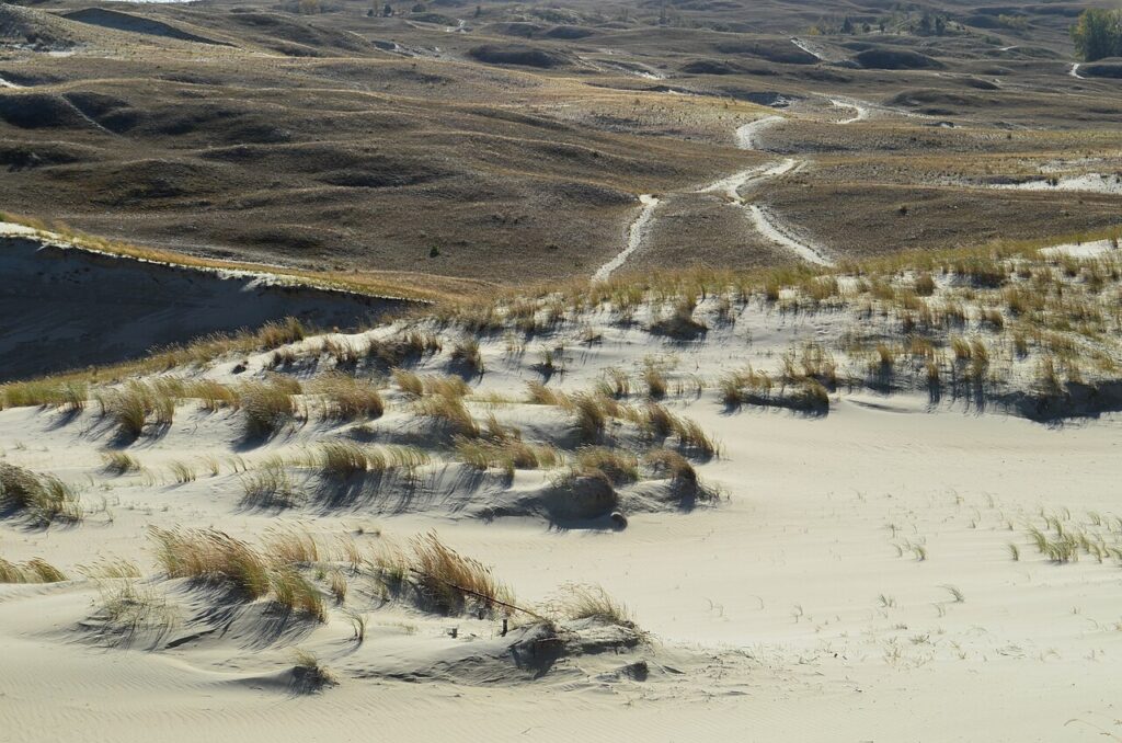
The Curonian Spit’s landscape is produced by a dynamic interplay of sand, wind, and water that has been continuous for approximately 5,000 years: the spit itself is a Holocene formation, built from sand carried south along the Baltic coast by longshore drift and accumulated into the present barrier form only after the Baltic Sea reached its current level approximately 5,000 BCE. The most dramatic component of the spit’s landscape is its dune system — a series of parabolic (U-shaped) foredunes and inland dunes formed by the prevailing westerly winds that drive sand eastward from the Baltic beach across the narrow spit toward the Curonian Lagoon. The Parnidis dune complex near Nida (Lithuanian section), the highest surviving active dune system on the spit at 52 metres above sea level and with a crest extending approximately 4 km north-south, is the most visited natural feature of the Lithuanian National Park; a 2-km boardwalk trail ascends the western face of the dune to a panoramic viewpoint where the Baltic Sea, the forest-covered dead dunes to the north, the lagoon to the east, and the geometrically pure sand landscape of the dune’s eastern slip face and the “Valley of Death” (Mirties slėnis — a name given to the area of dune encroachment that buried several villages in the 17th–19th centuries CE) are simultaneously visible. The “Great Dune Ridge” (Nagliu rezervatas on the Lithuanian section, Visiachiy Bor on the Russian section) is the inland zone of stabilised “grey” or “dead” dunes — dunes that advanced inland and buried forest and settlements in the 16th–19th centuries CE (a period of massive sand mobilisation associated with the clear-cutting of the spit’s pine forests by the Teutonic Order and later Prussian administrations, which removed the vegetation cover that had previously anchored the sand) and have since been partially re-stabilised by reforestation programmes begun in the 19th century by German forest engineer Georg David Kuwert (1811–1883 CE) and continued under Lithuanian and Russian management. The history of the spit’s landscape is effectively the history of human impact and ecological recovery: the original forest cover stripped, the dunes mobilised, villages buried, a 19th-century reforestation campaign (one of the earliest large-scale ecological restoration projects in European history), and the present landscape of pine-forested dead dunes, active parabolic foredunes, and lagoon-edge wetlands that give the Curonian Spit its characteristic interplay of green and gold.
The Curonian Lagoon (Kuršių marios in Lithuanian, Kurshsky Zaliv in Russian) — a 1,584-square-kilometre brackish water body enclosed between the spit’s eastern shore and the Lithuanian/Kaliningrad mainland — is one of the largest brackish lagoons in Europe, connected to the Baltic Sea only through the 400-metre Klaipėda Strait at the northern end of the spit. The lagoon’s water is nearly fresh at its northern (Lithuanian) end, where the Nemunas River delivers the majority of the inflow, and more saline at its southern (Russian) end near the Klaipėda Strait, creating a salinity gradient that supports a remarkable diversity of fish species (the spit’s traditional fishing economy was based primarily on eel, bream, pike-perch, and smelt caught in the lagoon using traditional Curonian trap-net methods). The Curonian traditional fishing culture — documented by German ethnographers in the 19th century and partially survived into the present in the fishing villages of Pervalka and Preila (Lithuanian section) and Rybachy (Rossitten in the historical German name, Russian section) — is expressed architecturally in the distinctive painted “weather vanes” (vėtrungės) mounted on the gable ends of fishing houses on the Lithuanian section: tall carved and painted wooden poles topped with geometric silhouettes (a fish, a mermaid, a mill, a boat) whose specific design identified the owner’s family, village, and occupation — a pre-literate maritime identity system unique to the Curonian fishing communities and now maintained as a living folk craft tradition in the National Park villages.
Klaipėda, Kaliningrad and the Baltic heritage circuit Klaipėda port city · Königsberg Cathedral Kaliningrad · Thomas Mann Villa Nida — 0 to 120 km
Klaipėda (population approximately 150,000) — Lithuania’s only seaport city, on the northern bank of the Klaipėda Strait opposite the northern tip of the Curonian Spit — is the primary gateway to the Lithuanian National Park section of the inscription, served by ferries to the spit’s northern tip (Smiltynė, 10-minute crossing, departures every 20 minutes in summer). Klaipėda’s own heritage is Baltic German: founded as Memel in 1252 CE by the Teutonic Order, the city was the capital of the Memel Territory, a semi-autonomous region under French League of Nations administration from 1919 to 1923 CE (when it was annexed by Lithuania in a military coup, giving Lithuania its only seaport), and part of Nazi Germany 1939–1945 CE. Klaipėda’s 19th-century Neoclassical Theatre Square (where the 1939 German annexation was announced from the theatre balcony by Hitler — a unique piece of 20th-century European political geography) and its restored Old Town (a grid of 17th–19th century half-timber merchant houses) are the city’s main heritage assets. Thomas Mann’s summer villa in Nida (40 km south of Klaipėda by road through the National Park, or approximately 2 hours by boat along the lagoon shore) is now a museum: Mann (1875–1955 CE, Nobel Prize in Literature 1929 CE) built a steeply-roofed holiday house in the traditional Curonian thatched style above Nida in 1930 CE and spent three summers (1930–1932 CE) there, writing portions of Joseph and His Brothers; he left Europe permanently in 1933 CE after Hitler’s rise to power and never returned to Nida. The villa’s museum offers a rare glimpse of Mann’s working environment (his original desk, manuscripts, and library in the reconstructed study) and of the Nida artistic colony that attracted Lovis Corinth, Max Pechstein, Ernst Barlach, and other German Expressionist artists in the early 20th century.
One Hundred and Twenty Kilometres south of Nida (crossing the Russian-Lithuanian border at Nida, then 120 km through the Russian section of the spit and the Kaliningrad mainland by road), Königsberg Cathedral (Kaliningrad, Russia) — the medieval brick Gothic cathedral of the former capital of the Duchy of Prussia, completed 1380 CE, heavily damaged in World War II and partially restored since 1994 CE — is the most significant heritage monument in Russia’s Kaliningrad Oblast. The cathedral contains the tomb of Immanuel Kant (1724–1804 CE), the philosopher who lived his entire life in Königsberg and whose Critique of Pure Reason (1781 CE) is among the most influential works in Western philosophical history. Kaliningrad (founded as Königsberg by the Teutonic Order in 1255 CE, re-founded under the present name after Soviet annexation in 1945 CE) is a Russian exclave between Lithuania and Poland with an extraordinary layered history: Teutonic Order stronghold, capital of the Duchy of Prussia and birthplace of Prussian statehood (1525 CE), part of the German Empire, devastated in World War II (90% of the historic centre destroyed), and now a Russian administrative region with approximately 400,000 inhabitants. The Curonian Spit National Park’s Russian section (headquartered in Zelenogradsk, 35 km from Kaliningrad city centre) is the primary reason for international heritage visits to Kaliningrad Oblast.
Practical information
Access to the Lithuanian section: Klaipėda is served by buses from Vilnius (approximately 3.5 hours) and Riga (approximately 2.5 hours), and by the daily Minsk–Klaipėda overnight train; no airport (nearest airports: Palanga, 30 km north, with seasonal European connections; Vilnius, 300 km southeast, with full European and international connections). Ferry from Klaipėda to Smiltynė (10-minute crossing, runs 24 hours, approximately every 20 minutes in summer; passenger ferries and car ferries are separate; car ferry reservation strongly recommended in July–August). Road through the Lithuanian section to Nida: 40 km, approximately 45 minutes; a single road runs the length of the Lithuanian park with signed access to the main dune viewpoints. Nida has approximately 8–10 hotels and guesthouses; advance booking essential in July–August. Entrance fee for the Lithuanian National Park: approximately €3–5 per person per day (vehicle fee approximately €5 per day). Access to the Russian section: from Kaliningrad city (flights from Moscow Domodedovo approximately 2 hours) to Zelenogradsk (35 km by bus or car from Kaliningrad) then into the National Park by road. Lithuanian-Russian border crossing on the spit: open to EU citizens and Russians with appropriate visas; non-EU nationals should verify current visa requirements for Russia and Lithuania before planning a combined visit (the Russian Kaliningrad exclave has its own visa arrangements separate from mainland Russia). Best season: June–August for maximum beach and dune conditions; May and September for lower crowds and wildflower tundra; October for the Curonian Spit amber season (amber washed up on Baltic beaches increases after autumn storms).
Frequently Asked Questions
Why were Curonian villages buried by sand dunes and how many were lost?
The burial of Curonian Spit villages by advancing sand dunes in the 16th–19th centuries CE is one of the best-documented examples of human-induced landscape catastrophe in European environmental history, and the process responsible for the Curonian Spit’s most dramatic landscape feature — the “Dead Dune” (Nagliu) zone of inland dunes. The process began when the Teutonic Order and later Prussian administrations systematically logged the pine and oak forests covering the spit’s dune system from the 16th century onward, using the timber for ship construction, fortification building, and fuel for the amber trade’s processing facilities. The forest cover — which held the sand in place under the mechanical binding of tree roots and the windbreak effect of the forest canopy — was progressively removed, and the exposed sand was set in motion by the prevailing westerly winds. From approximately the mid-16th century through the 19th century, large parabolic dunes advanced eastward across the spit at documented rates of 3–20 metres per year, burying successive villages. Fourteen Curonian fishing villages were buried or abandoned due to dune encroachment between 1600 and 1825 CE: documented examples include Karvaičiai (buried approximately 1640 CE), Nagliai (buried approximately 1755 CE, the dune field now named after it), Šarkuva (buried approximately 1797 CE), and the German Prussian village of Alt-Pillkoppen (buried approximately 1800 CE). The most famous burial event is the destruction of the German village of Pilkoppen (now Morskoe/Морское on the Russian section), which the advancing dune reached in stages over approximately 30 years; the villagers relocated to a new site 2 km away. The systematic reforestation campaign begun by the Prussian forestry administration in the 1820s–1830s (using the techniques developed by Georg David Kuwert, who first demonstrated that mountain pine (Pinus mugo) planted as a pioneer species on the dune face could be used to stabilise the sand for subsequent planting of Scots pine) gradually arrested the dune advance over the following century. By 1900 CE, approximately 90% of the previously active dunes had been stabilised by reforestation; the present active dune zone is limited to the maintained “Great Dune Ridge” parabolic system near Nida and a few smaller foredune areas at the Baltic beach edge.
Who were the Curonians and what happened to the Baltic people of the spit?
The Curonians (Kouroi in Latvian; Kursiai in Lithuanian; Kuren in German) were a Baltic tribal people who inhabited the eastern Baltic coast of the present-day Kurzeme (Courland) region of Latvia and the northern end of the Curonian Spit from approximately the 1st millennium CE. The Curonians were neither Latvian nor Lithuanian in the modern ethnic sense but belonged to the pre-Christian Baltic tribal world documented by Roman and Arab geographers as the producers of Baltic amber, which was among the most valued trade commodities in the ancient Mediterranean world; Curonian amber was traded via overland routes to Rome and by sea to Scandinavia, generating sufficient wealth to produce the elaborate gold and bronze jewellery found in Curonian burial mounds. The Curonians were gradually absorbed by the Teutonic Order’s Baltic Crusade: militarily defeated in the 13th century CE (the Curonian tribal leaders submitted to the Livonian Order by 1267 CE), subsequently converted to Christianity, and progressively assimilated into the German Prussian and Lithuanian populations of the region over the following three centuries. The population of the Curonian Spit by the 16th–19th centuries CE was linguistically a distinct group called “Curonian Neringa” (Kuršininkais in Lithuanian), speaking a now-extinct Baltic language known as Curonian (not to be confused with modern Latvian Courland dialect) that was still documented by German ethnographers in the late 19th century but had no surviving native speakers by approximately 1930 CE. The present population of the Lithuanian and Russian sections of the spit descends from a mixture of Prussian German settlers, Curonian-origin families who assimilated into German and Lithuanian linguistic communities, and post-World War II Soviet resettlement populations (most of the pre-war German and Lithuanian population was expelled or fled in 1944–1945 CE, and the Russian section was resettled primarily by Russians from other Soviet republics). The Curonian Spit’s UNESCO inscription specifically cites the “cultural continuity of human settlement from prehistoric times to the present” as a component of Outstanding Universal Value — an acknowledgment of the millennia of cultural succession that the inscription encompasses.
What role did the Curonian Spit play in Northern European art history?
The Curonian Spit’s landscape attracted one of the most significant clusters of German and Northern European Expressionist and late-Romantic artists in the early 20th century, making Nida (Nidden in German) one of the most important artists’ colonies in the history of Northern European modernism. The colony began in 1895 CE when the German painter Ernst Bischoff-Culm “discovered” the Nida dune landscape and wrote about it in German art journals, attracting subsequent visits from major figures of the Berlin and Munich art scenes: Max Pechstein (1881–1955 CE, a founding member of Die Brücke Expressionist group) painted 11 summers in Nida (1909–1920 CE), producing his most celebrated work in the synthesis of the spit’s transparent Baltic light and colour with his Expressionist palette; Lovis Corinth (1858–1925 CE) painted the Nida dune landscape in 1913 CE; Ernst Barlach (1870–1938 CE, sculptor and playwright) worked in Nida; and numerous second-tier German painters and graphic artists used Nida as a summer working location. The colony’s appeal was specifically the Curonian dune landscape’s combination of North African scale and atmosphere (the vast, sculptural parabolic dunes reaching 52 metres, the golden sand, the near-total absence of human settlement in the dune zone) with the cool Baltic light and the lagoon’s still, reflective water surface — a landscape that appeared simultaneously primeval and architecturally abstract in a way that appealed strongly to the Expressionist aesthetic of stripping natural form to its essential line and colour. Thomas Mann’s presence in Nida (1930–1932 CE) added a literary dimension to the colony: Mann described the Parnidis dune’s evening light in a 1931 essay as the most beautiful landscape he had encountered in Europe. The combination of Mann’s literary celebrity, Pechstein’s Expressionist canvases (now in major German museum collections), and the subsequent cultural memory of pre-war German summer culture in the region gives the Nida artists’ colony a significance in German cultural history that extends beyond its geographic remoteness.
EXCERPT: Curonian Spit (UNESCO 2000, Lithuania and Russia) — a 98-km sand spit enclosing the Curonian Lagoon, with Europe’s tallest inland dunes at 52 metres near Nida, where 14 villages were buried by advancing sand in the 17th–19th centuries and Thomas Mann wrote in his 1930 thatched villa.
META: UNESCO World Heritage Sites near the Curonian Spit Lithuania Russia: Klaipėda gateway city, Königsberg Cathedral Kaliningrad 120 km south, Vilnius Historic Centre 300 km east — Baltic Sea heritage circuit from the Teutonic Order’s Baltic Crusade to 20th-century German Expressionist art colony at Nida.
Sources
- S1 — UNESCO World Heritage Centre — Curonian Spit (Ref. 994) — https://web.archive.org/web/20230601000000/https://whc.unesco.org/en/list/994/
- S2 — Curonian Spit National Park Official Portal — https://park-kosa.ru/
Spotted an error? Write to the editors and we correct it the same day.