
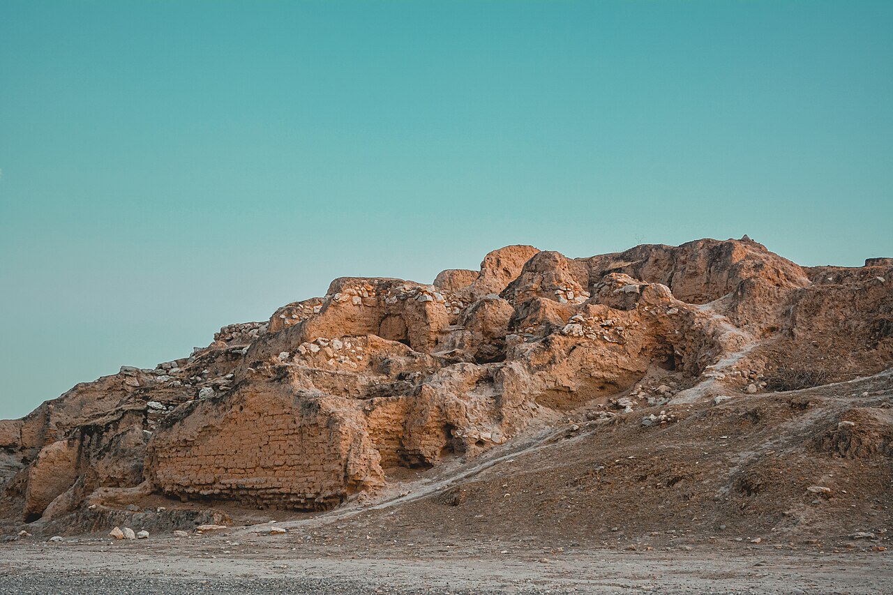
Ashur (also written Assur or Aššur; Arabic: “آشور”; Akkadian: “Aššur” — the city named for and identified with the national god of the Assyrian people, the supreme deity of the Assyrian pantheon whose name was shared with the city, the people, and the land: the Assyrians called themselves “māt Aššur” [land of Assur], a perfect coincidence of divine, ethnic, and geographic identity that is unique among the great cultures of the ancient world), inscribed by UNESCO in 2003 (and simultaneously placed on the List of World Heritage in Danger — due to the proposed Makhoul Dam project that threatened to flood the site, though the dam project was subsequently cancelled), is the oldest Assyrian city and the first capital of the Assyrian Empire — a city founded approximately 2500 BCE on a promontory above the western bank of the Tigris River in the northern Mesopotamian plain (approximately 350 km north of Baghdad and approximately 90 km south of Mosul, in the Saladin Governorate of Iraq), that served continuously as the religious capital of Assyria for approximately 2,000 years (from its foundation approximately 2500 BCE to its destruction by the Medes and Babylonians approximately 614 BCE) even after the Assyrian political capital was moved northward to Kalhu (Nimrud), Dur-Sharrukin (Khorsabad), and finally Nineveh (modern Mosul). Ashur’s unique significance in the history of the ancient Near East is threefold: as the oldest known Assyrian city and the location of the most important Assyrian temple complex (the Ishtar temple, with building phases documented from approximately 2500 BCE to the late Assyrian period); as the royal burial ground of the Assyrian kings (the tombs of most of the Assyrian kings were at Ashur — including remarkable vaulted mud-brick tombs of the Middle Assyrian and Neo-Assyrian periods, some intact with royal furnishings, discovered by the German archaeological mission of Walter Andrae 1903–1914 CE); and as the centre of the “Assur trading network” of the Middle Bronze Age (approximately 2000–1750 BCE), in which Assyrian merchant colonists established a remarkable long-distance trade network connecting Ashur to the Anatolian plateau.
The Ashur trading network (kārum Kanesh) and the Assyrian Bronze Age commercial system Assur Temenos · Tigris River Promontory · Royal Tombs · Baghdad 350 km · Mosul 90 km · Erbil 120 km
The most remarkable and least-known achievement associated with the city of Ashur is the ancient Assyrian long-distance trade network of approximately 2000–1750 BCE — the “Old Assyrian trade network”, documented by the approximately 23,000 cuneiform tablets found in the excavation of the Assyrian merchant colony at Kaneš (Kanesh, modern Kültepe near Kayseri in central Anatolia, Turkey), which constitute the most extensive archive of ancient commercial documentation in the world and provide an extraordinarily detailed picture of how Bronze Age international trade actually functioned. The Assyrian merchants of the Old Assyrian period (approximately 2000–1750 BCE) established a network of commercial colonies (“kārum” — the Akkadian word for a “quay” or commercial district, which gave its name to these merchant colonies) in approximately 30–40 cities across the Anatolian plateau, with the principal colony (“the” kārum) at Kaneš. The traders carried goods on donkey caravans (approximately 200–300 donkeys per caravan, each carrying approximately 65–70 kg of goods in standardised textile bales and in the saddlebags called “huluppatum”) from Ashur to Kaneš (approximately 1,000 km — about a 6-week journey) and back, trading Mesopotamian-produced tin (essential for the manufacture of bronze — bronze is approximately 90% copper + 10% tin, and tin was almost entirely absent from the Mesopotamian and Anatolian mineral world, having to be imported from distant sources [the exact origin of the Old Assyrian tin is still debated — Afghanistan, Central Asia, and even Cornwall in England have been proposed]) and Babylonian textiles for Anatolian silver (which Anatolia had in abundance and Mesopotamia lacked). The tablets from Kaneš document the commercial correspondence of approximately 500 individual Assyrian merchants across approximately 250 years — letters between partners, bills of lading, commercial contracts, lawsuits, and personal family correspondence — that collectively illuminate an economic system of striking sophistication: fixed exchange rates, commercial credit, interest-bearing loans, partnership agreements (the “naruqqum” partnership contract, in which a merchant-investor provided capital to an active trader in return for a fixed profit share after a specified term), and insurance-like arrangements for caravan loss. The city of Ashur itself (the departure point of all these caravans) was governed during the kārum period not by a king but by a “City Assembly” (the “alum Aššur” — literally “city of Assur”) and a senior official called the “limmu” (a rotating annual position whose name became the method of dating Old Assyrian documents — the year was referred to as “the year of the limmu of so-and-so”, creating the “eponym list” that is one of the primary tools for dating events in Old Assyrian history). This republican-like city government is unique among ancient Mesopotamian city-states of the period and reflects Ashur’s character as a merchant city rather than an agricultural or military kingdom.
Practical information
Ashur is approximately 350 km north of Baghdad and approximately 90 km south of Mosul, accessible by road from both cities. The site is on the western bank of the Tigris approximately 5 km from the town of Qal’at Sherqat (the modern administrative centre of the area). The Iraqi State Board of Antiquities and Heritage manages the site; the German archaeological mission (the Deutsche Orient-Gesellschaft) conducted the original excavations 1903–1914 CE and has returned for additional seasons since the 2000s CE. The site remains on the List of World Heritage in Danger (the dam threat has receded but concerns about site management and security remain). Visitor access should be verified through current Iraqi tourism channels; the security situation in the Saladin Governorate has been generally stable since approximately 2017 CE but should be checked. Best visiting months: October–April (Saladin summer temperatures regularly exceed 45°C; March–April also has wildflower season in the northern Iraqi plains).
Frequently Asked Questions
Who were the Assyrians and what was the Assyrian Empire?
The Assyrians (Akkadian: “Aššurāyu” — the people of Aššur, i.e. the city/god of Ashur) were a Semitic people of northern Mesopotamia who spoke Akkadian (the Semitic language of ancient Mesopotamia, ancestor of modern Aramaic and related to Hebrew and Arabic) and created one of the longest-lasting and most successful imperial polities in world history. The Assyrian historical sequence is conventionally divided into three main periods: (1) the Old Assyrian period (approximately 2000–1750 BCE) — the merchant city-state phase documented at Kaneš, when Ashur was the centre of a commercial network rather than a territorial empire; (2) the Middle Assyrian period (approximately 1365–1056 BCE) — the first expansion phase, when the Assyrian kings of the Mitanni-successor state began the military conquests that created a significant territorial empire in the northern Mesopotamian zone; and (3) the Neo-Assyrian Empire (approximately 911–609 BCE) — the peak imperial phase, when the Assyrian kings created the largest empire the ancient Near East had yet seen, eventually extending from Egypt and the Levant in the west to Iran and Anatolia in the north and east. The Neo-Assyrian Empire is the period of the most famous Assyrian kings (Ashurnasirpal II, Shalmaneser III, Tiglath-Pileser III, Sargon II, Sennacherib, Esarhaddon, and Ashurbanipal) and the most spectacular Assyrian art (the palace reliefs of Nimrud, Khorsabad, and Nineveh, with their scenes of royal hunt and military campaign, are the primary holdings of the British Museum’s Assyrian collection and were influential on European neoclassical decorative art). The Neo-Assyrian Empire fell rapidly and catastrophically: in approximately 614 BCE the Medes (an Iranian people from the Zagros) sacked and destroyed Ashur; in 612 BCE the combined forces of the Medes and Babylonians destroyed Nineveh, killing the last Assyrian king Sinsharishkun; in 609 BCE the last Assyrian military resistance was defeated at Harran. The speed of the Assyrian collapse (from the largest empire in the world to total military defeat in approximately 10 years) is one of the great puzzles of ancient history — multiple factors are proposed, including internal political fragmentation, military overextension, ecological stress in the Assyrian heartland, and the new military effectiveness of the Median cavalry-based army.
What was discovered in the royal tombs of Ashur and why are they significant?
The royal tombs of Ashur (vaulted mud-brick tomb chambers built beneath the floor of the Old Palace and the New Palace in the city, discovered during the German excavations of 1903–1914 CE under Walter Andrae) are among the most significant royal burial deposits from the ancient Near East — complementing the royal cemetery of Ur (the “death pits” of the Early Dynastic period, approximately 2600 BCE, excavated by Leonard Woolley in the 1920s CE) and the royal tombs of Philip II of Macedon at Vergina (discovered 1977 CE) as outstanding examples of royal burial practice in the pre-classical world. The Ashur royal tombs contain the burials of several Middle Assyrian and Neo-Assyrian kings (approximately 1300–700 BCE), and while many had been plundered in antiquity, several yielded extraordinary contents: (1) vaulted brick chambers with corbelled arched roofs (the “Assyrian vault” — a construction technique of stepping successive courses of bricks inward to create an arch without a centering form, allowing the construction of vaulted spaces without timber — a remarkable engineering achievement given the near-total absence of timber in the Mesopotamian lowland); (2) royal furnishings including gold and silver objects, carved ivory furniture components (the Assyrian palaces of the Neo-Assyrian period were famous for their use of carved ivory furniture inlay — the ivories from Nimrud and the Ashur tombs are among the finest products of ancient Near Eastern applied art); (3) cuneiform tablets with texts related to the burial ritual and the afterlife provisions for the deceased king; and (4) remains of human attendants (in some tombs, evidence of secondary burials accompanying the main royal burial, consistent with the ancient Near Eastern royal burial practice of interring servants or family members with the deceased ruler). The Ashur tombs were incompletely published by Andrae in the early 20th century, and subsequent re-analysis of the original documentation (particularly the work of the Iraqi scholar Abdul Amir Hamadan in the 1980s CE and 1990s CE) has revealed that many of the tombs contained more material than was initially reported — including several intact burials that yielded gold jewelry, cylinder seals, and other small objects of extraordinary craftsmanship that represent the peak of Middle Assyrian metalwork. The original finds from Andrae’s excavations are primarily in the Vorderasiatisches Museum in Berlin; finds from subsequent Iraqi excavations are in the Iraq Museum in Baghdad and the Mosul Museum (the Mosul Museum objects were largely destroyed or looted by ISIS in 2015 CE, in the same campaign that damaged the Hatra site).
EXCERPT: Ashur (Qal’at Sherqat), Iraq, UNESCO-inscribed 2003 (also on the List of World Heritage in Danger) — the oldest Assyrian city and religious capital for approximately 2,000 years (circa 2500–614 BCE): the Ashur trading network documented by 23,000 cuneiform tablets at Kaneš, royal tombs of the Assyrian kings, and the Tigris River promontory city where the national god Aššur gave his name to the city, the people, and the empire.
META: UNESCO World Heritage Sites near Ashur Iraq: Hatra Iraq 100 km north (UNESCO 1985), Samarra Archaeological City Iraq 150 km south (UNESCO 2007), Babylon Iraq 350 km south (UNESCO 2019) — Ashur Qal’at Sherqat Iraq UNESCO 2003, Assyrian Empire history, kārum Kanesh Old Assyrian trade network, Mesopotamian royal tombs Middle Assyrian, Assyrian city walls Tigris River promontory, World Heritage in Danger dam threat.
Sources
- S1 — UNESCO World Heritage Centre — Ashur (Qal'at Sherqat) (Ref. 1130) — https://web.archive.org/web/20230601000000/https://whc.unesco.org/en/list/1130/
- S2 — UNESCO World Heritage Centre — Statement of Outstanding Universal Value (Ref. 1130) — https://whc.unesco.org/en/list/1130/
Spotted an error? Write to editorial@culturalheritageonline.com and we correct it the same day.