
Curated Itinerary
Pomezia Founded Town Walk — the 2PST Civic Ensemble of 1939
Of the five towns raised on the drained Pontine Marshes, Pomezia came last: founded in 1939, it is the youngest of them, and its founding core is small enough to cross in a few hundred metres. Two buildings carry it. The Casa Comunale, with the Torre Civica over the square, was designed by the 2PST group as the centrepiece of the civic ensemble and inaugurated in October. A short walk away stands the Palazzo delle Poste e Telegrafi, built in 1938 as part of the same coordinated plan — state architecture in modernist dress, put on the ground before the town around it existed. Two stops, then, and a walk of minutes rather than hours. What it shows is not distance but compression: an entire civic programme, government and tower and post, fitted into one square. Stefano Vigolo tells the full story in a separate article.
Take this route into Google Maps
From Casa Comunale and Torre Civica, Pomezia — the 2PST Civic Ensemble (1938-39) to Palazzo delle Poste and Telegrafi of Pomezia, in the order we curated them.
➤ Turn on the navigator in Google MapsIt opens in the Google Maps app with every stop already loaded, in the order we put them in. From there the route is yours: pick how you travel — on foot, by bike, by public transport or by car — change where you start and where you end, drag the stops into a different order, and add places of your own along the way.
The nucleo aulico of Pomezia (1939), last of the Pontine new towns: the Casa Comunale with the Torre Civica and the founding post office. Read the full story in the dedicated article Pomezia, 1939: the Last New Town and its Civic Ensemble, by Stefano Vigolo.
Step by step
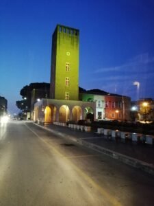
Casa Comunale and Torre Civica, Pomezia — the 2PST Civic Ensemble (1938-39)
The town hall and tower of the last Pontine new town, centrepiece of the founding civic ensemble designed by the 2PST group and inaugurated in October…
Palazzo delle Poste and Telegrafi of Pomezia
A 1938 postal palace built as part of Pomezia's coordinated Fascist-era urban development, embodying modernist principles of state-directed planning…
Download for tour navigation
PDF is the stop list with GPS, to print or keep on the phone. GPX for Garmin / Komoot / OsmAnd. KML for Google Earth and Maps.
Walk it with the navigator on
It opens in the Google Maps app with every stop already loaded, in the order we put them in. From there the route is yours: pick how you travel — on foot, by bike, by public transport or by car — change where you start and where you end, drag the stops into a different order, and add places of your own along the way.
To keep the route in the app instead of opening it once, download the KML above and import it into Google My Maps — Create a new map, then Import: the route then sits among your own maps in Google Maps, with the stops and our notes attached to each one.