

For two and a half centuries Japan mined gold and silver on Sado without the machines the rest of the world was adopting, and struck the coins on the island itself. The rock, the tunnels and the drained valleys are still there.
At a glance
The Sado Island Gold Mines are not one mine but a landscape of them, on the west coast and in the hills behind it. The property the World Heritage Committee inscribed in 2024 joins two areas with different geology: the Nishimikawa placer mine, where gold was washed out of river gravel, and the Aikawa–Tsurushi gold and silver mine, where it was cut out of hard rock. Aikawa, the largest of them, sits above the port town of the same name. Visitors reach it by road across an island that has been mining since at least the twelfth century, and that stopped only in 1989.
Key facts
- Where: Aikawa, Sado Island, Niigata Prefecture, Japan
- Coordinates: 38.0409, 138.2578 — open in Google Maps
- World Heritage: inscribed 27 July 2024, criterion (iv), reference 1698
- Components: Nishimikawa placer gold mine; Aikawa–Tsurushi gold and silver mine (the Tsurushi silver mine and the Aikawa gold and silver mine)
- First written gold: a twelfth-century tale collection, the Konjaku Monogatarishū, mentions gold sand from Sado
- Under the shogunate: direct Tokugawa control from 1601; the Sado magistrate’s office was built in 1604
- Closed: the mines suspended operations in 1989
History
Gold on Sado enters the written record as sand, not as rock. The Konjaku Monogatarishū, compiled in the twelfth century, tells of a prospector who crosses from Noto and comes back with gold wrapped in cloth; the story is attached to Nishimikawa, the placer workings that are treated as the oldest of their kind on the island. Hard-rock mining came later and from outside. The Tsurushi silver mine was discovered in 1542 and became the largest silver working on Sado, with more than six hundred traces of excavation recorded; engineers from the Iwami silver mine brought cupellation, the lead process that separates silver from ore, and that knowledge made the Aikawa gold veins workable.
In 1601 Tokugawa Ieyasu took the island under his direct control and began developing Aikawa in earnest. Ōkubo Nagayasu arrived as magistrate in 1603, an office building followed in 1604, and by 1621 koban coins were being struck on Sado. In the Genna and Kan’ei years of the early seventeenth century the mines are estimated to have produced more than 400 kilograms of gold a year, with some 10,000 kan — about 37.5 tonnes — of silver delivered annually to the shogunate. Sado is the only place in Japan where the whole chain, from ore to minted coin, happened on one site, and more than a hundred picture scrolls record the work.
What the property is now celebrated for is what happened next: because Japan’s seclusion policy kept foreign machinery out, mining, smelting and refining stayed manual, and manual technique kept being refined rather than replaced, for some 250 years while other countries mechanised. The drainage problems of the later Edo period were met with tunnels, among them the Minamizawa adit of 1696. The Meiji government took the mines over in 1868, sent Western engineers in 1869, and by 1877 had sunk Japan’s first Western-style vertical shafts, the Ōdate shaft among them. Mitsubishi bought the mine in 1896 and electrified it; production peaked around 1940 at roughly 1,500 kilograms of gold and 25 tonnes of silver a year. The Tsurushi mine closed in 1946 and the workings were suspended in 1989.
The 2024 inscription carried a dispute with it. Japanese recruiting of Korean workers for the mine began in February 1939, when the Korean peninsula was Japanese territory, and about 1,200 came between then and March 1945; Korean sources describe the labour as forced, and Japan’s ambassador to UNESCO acknowledged the forced-labour history in 2015. An exhibition on working conditions was installed for the nomination, and critics have argued that it does not name forced labour.
What you see
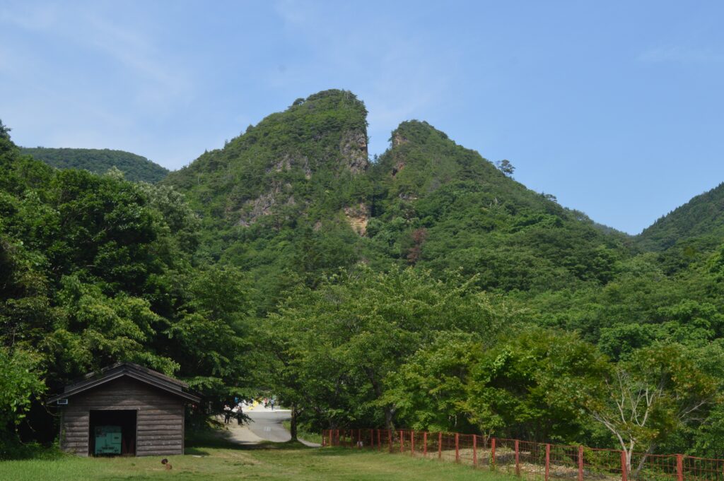
The signature of the place is the Doyu-no-Warito, a vein worked from the surface until the cut split the hillside into two standing walls of rock, which now reads as a notch in the ridge above the mine buildings. Around it the ground is full of the shape of the work: adits with the marks of chisels in their walls, the reservoirs and channels of the onagashi method that washed placer gold out of the Nishimikawa gravels, and the levelled platforms where ore was dressed by hand. The Aikawa settlement is itself part of the property — a planned mining town laid out below the magistrate’s office, with the house plots of the officials and the miners still legible in the street pattern.
On the industrial side the twentieth century left its own layer: the Kitazawa flotation plant, built with German technology from 1885, stands as concrete and steel above the valley, and the Ōdate shaft headframe marks the Meiji attempt to catch up with the world the island had been sealed from.
Practical information
- What to allow: half a day at Aikawa for the visitor mine and the Doyu-no-Warito, a full day if you add Nishimikawa and Tsurushi
- Terrain: the sites are outdoors and on slopes; the tunnels are cool and damp even in summer
- Footwear: walking shoes, not sandals
- Access maps: Niigata Prefecture publishes maps for the island and for the Aikawa area (access page)
Getting there
Sado is an island, and everything arrives by water or by air. Ferries and jetfoils cross from Niigata city to the ports of Ryōtsu and Ogi — the operator is Sado Kisen, and the crossing is the reason a visit takes planning rather than an afternoon. From the ports the mine areas are reached by road; Aikawa is on the west coast, on the far side of the island from Ryōtsu. Buses run on the island but thinly, so a car or a taxi makes the difference between seeing one component and seeing three.
Nearby
- Sado Island — the island itself: the crested ibis, the terraced coast and the exile routes of Zeami and Nichiren
- The Sado magistrate’s office site, Aikawa — the administrative centre of the shogunate’s mine, part of the same World Heritage property
- Tsurushi, on the north-west coast — the silver mine of 1542 and the Otaki-mabu tunnel with its chisel marks
Sources
- Niigata Prefecture, What is the “Sado Island Gold Mines”? — components, criterion (iv), and the chronology from the twelfth century to 1989 (read 21 October 2026)
- UNESCO World Heritage Centre, Sado Island Gold Mines, reference 1698 — inscription of 27 July 2024
- Wikipedia, Sado mine — production figures for the early Edo period and 1940, Meiji-era shafts, Mitsubishi, and the Korean labour record with its sources
- Coordinates verified against OpenStreetMap / Nominatim, which resolves 史跡 佐渡金山 (Historic Site Sado Kinzan) at these coordinates
Find it on the map
See this place and what’s around it →📷 Become a Cultural Heritage Online photographer
Share your photos of places: they stay published under your name as the author. The more they're seen, the more you get noticed — and soon a contest will reward the most appreciated photos.
Log in or sign up free to add a photo