
.jpg)
A harbour city of Aeolis that Herodotos already knew, buried under a Turkish seaside resort, where an excavation reopened in 2012 has just uncovered a mosaic floor with fifteen panels and two household animals identified by name.
At a glance
Adramytteion stood at the head of the gulf that still carries its name, on the Aeolian coast of north-western Anatolia. Its site is Ören, a shore neighbourhood of Burhaniye in Balıkesir province; the modern town of Edremit inherited the name but not the place. The city was registered as a protected site in 1975 and declared an archaeological site in two degrees by decisions of the Bursa conservation board in 1989 and 1990. Excavation has run since 2012 under the Balıkesir Kuva-yi Milliye Museum Directorate, with the Ministry of Culture and Tourism’s permit, and in 2026 it published a Roman house of about 730 square metres arranged around an atrium, with mosaic floors in its reception halls.
Key facts
- Where: Ören, Burhaniye district, Balıkesir province — about four kilometres west of Burhaniye town centre and some twenty-four kilometres south of Edremit
- Ancient names: Greek Ἀδραμύττειον, Latin Adramyttium; the Gulf of Adramyttium is today’s Edremit Körfezi
- Protection: registered in 1975 under the then Antiquities Law no. 1710; declared 2nd-degree and 1st-degree archaeological site by decisions of the Bursa Board for the Conservation of Cultural and Natural Property in 1989 and 1990
- Extent: 46.2 hectares of 1st- and 2nd-degree archaeological site, with a further 61.2 hectares of interaction and transition zone around it
- Excavation: surveys from the late 1990s; campaigns under Engin Beksaç from 2001 and Tülin Çoruhlu from 2003 to 2006; the present campaign since 2012, run by the Balıkesir Kuva-yi Milliye Museum Directorate under the scientific supervision of Hüseyin Murat Özgen of Mimar Sinan Fine Arts University, sponsored by Burhaniye municipality
- The Roman residence: about 730 m², built round an elongated atrium of roughly 11 by 6.5 metres, with three large halls; the North Hall measures about 7.7 by 4.7 metres
- Dating: the house in use in the second and third centuries AD; a hall added to the south after a destruction, in the fourth or fifth century; Hellenistic foundations on the same plot reused by the Roman builders
- Where the finds go: the Kuva-yi Milliye Museum in Balıkesir, whose archaeological floor has a hall named after Adramytteion
- Coordinates: 39.498575, 26.936124 · open in Google Maps
History
Herodotos names Adramytteion in his account of Xerxes’ march of 480 BC, and Xenophon’s Greeks passed it in 401 BC. From the fourth century BC it was an autonomous city minting its own coins, and one of the motifs it put on them was a winged horse. It passed from Lydian to Persian control, then to Alexander after the Granicus, then to Pergamon, and with the Attalid bequest into the Roman province of Asia in 133 BC. Under Rome it was one of the assize centres of the province, a shipbuilding and seafaring town living off the timber of the Kaz and Madra mountains and off two harbours open to the eastern Mediterranean. The Acts of the Apostles record that Paul left Caesarea for Rome in a ship of Adramyttium.
The Byzantine city was a bishopric under Ephesus from the fourth century. It was sacked by the Turkish commander Çaka Bey around 1090 and rebuilt by Eumathios Philokales in 1109, and it fell to the Karasid Turks in the fourteenth century. Archaeology and the written record agree that the site was abandoned in the early fourteenth century, its people dispersing to Edremit and the villages inland. The name went with them. Ören — the Turkish word means simply “ruins” — was resettled only from the 1950s, as a summer-house town, and the ancient city now lies under and between its streets.
The law caught up late. The site was registered in 1975, two years after Turkey’s Antiquities Law no. 1710; the Bursa conservation board fixed its two degrees of protection in 1989 and 1990, which froze building rights across the area. No conservation-led development plan was drawn up for the next twenty-two years, and the site lived under transitional rules while a modern resort grew around it. Planning work and the present excavation both began in 2012.
That excavation opened a roughly nine-thousand-square-metre undeveloped plot in two campaigns. Test trenches showed deep, multi-layered deposits; the second campaign reached a Roman residential quarter. The house is arranged round an atrium with three large halls off it, mosaic floors, frescoed walls, and an unusually complete set of water works: terracotta pipe runs, channels, drains and wet rooms, which the published assessment reads as part of a single architectural plan rather than as later additions. Under it, the foundations of a large Hellenistic building that the Roman builders reused.
The North Hall’s mosaic carries fifteen framed figurative panels in a three-by-five grid inside geometric borders. Among them are birds, a fish, a winged horse, a winged youth possibly to be read as Eros, a feline predator, Medusa and Gorgon heads, and pygmy figures attacking birds. Two panels show a cat and a dog, each with an inscription giving its name: the cat’s is reported as meaning “emerald”, the dog’s as Okyanos, “ocean”. Özgen has drawn two conclusions and offered both as questions rather than answers. The winged horse is the city’s own coin emblem, reappearing in a private house some five hundred years later. The pygmy motif belongs to the North African mosaic repertoire, which in a port trading with the eastern Mediterranean raises the possibility that the owner was a merchant with African connections. The full reading of the mosaics and their inscriptions has been deliberately held back for a separate specialist publication.
What you see
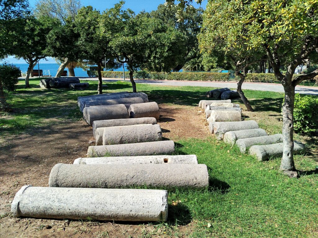
Adramytteion is not a ruin field you walk into. It is scattered through a small seaside town, in fenced enclosures between the houses and along the shore. In the park above the beach, rows of column drums lie on the grass where they were laid out — some in pale coarse-grained granite, some in grey and dark stone, most of them broken off at a joint, with cut blocks and a fragment of an architrave among them and the water of the gulf a few metres away through the oleanders.
The excavation areas themselves are behind green mesh fencing: open trenches cut a metre or two below the modern ground level, showing rubble-and-mortar wall footings, the outlines of small rooms, and sections of earth banked and stepped back. A brown enamel board at the entrance names the sponsor, the museum directorate and the scientific supervisor. Around the fence line, parked cars, a children’s playground and holiday houses come right up to the edge of the dig, which is the condition the conservation plan was written to deal with.
Whether the villa mosaics are lifted, reburied or sheltered is not stated in anything we have read; the project’s declared practice is to roof over its excavation areas, and its permit covers repair as well as digging. We record this as unresolved rather than guess.
Practical information
- The lapidary display in the shore park at Ören is in a public space and open at any hour.
- The excavation enclosures are fenced and worked seasonally; what is visible from the fence depends on the campaign.
- The finds from the site are shown in the Kuva-yi Milliye Museum in Balıkesir, about eighty kilometres inland, where one of the archaeological halls is named after Adramytteion.
- Note that Burhaniye also has a museum of its own with a similar name; the provincial museum is the one in Balıkesir city.
Getting there
Ören lies on the coast road west of Burhaniye, four kilometres from the town centre, on the southern shore of the Gulf of Edremit. Balıkesir is about eighty kilometres inland by road; Edremit and its Koca Seyit airport are to the north. Intercity coaches serve Burhaniye, and local minibuses run down to Ören in summer.
Nearby
- The ancient harbour works on the Ören shore, inside the protected area.
- Bergaz Tepe, the prehistoric and later mound at the edge of the site.
- The Kuva-yi Milliye Museum in Balıkesir, in the 1840 mansion of Giridizade Mehmet Pasha, where the armed resistance of 1919 was decided and where the site’s finds are displayed.
- Antandros, another excavated city of the same gulf, on the northern shore near Altınoluk.
Sources
- Seher Başlık and Mehmet Rıfat Akbulut, “Adramytteion Antik Kenti Bütüncül Koruma Planı”, Planlama 30/2 (2020), 221–241: the 1975 registration, the Bursa board decisions of 1989 and 1990, the two degrees of protection and their areas (46.2 ha plus a 61.2 ha transition zone), the freeze on building rights, the gap between 1990 and 2012, the sequence of excavators, and the ancient history including the ship of Adramyttium of Acts 27.
- Hüseyin Murat Özgen, “A Multi-Phase Residential Area at Adramytteion”, Uludağ Üniversitesi Sosyal Bilimler Dergisi 27/51 (2026), 427–448: the atrium-centred plan, the mosaic-paved reception rooms, the water management, the two main phases and the repair after a destruction, the Hellenistic foundations, and the statement that the villa type and the mosaics will be published separately.
- Hürriyet Daily News, “Roman-era villa uncovered at ancient city of Adramytteion” (from the Anadolu Agency interview with Özgen): the excavation’s permit-holder and supervisor, the two campaigns over about 9,000 m², the fifteen panels, the winged horse and the coins, the named cat and dog, the Medusa and pygmy figures and the North African reading, the fourth- or fifth-century hall and the reused Hellenistic foundations.
- Arkeonews, 31 August 2026, citing the 2026 article: the 730 m² figure, the atrium at about 11 by 6.5 metres, the North Hall at about 7.7 by 4.7 metres, and the three-by-five grid of panels.
- Ministry of Culture and Tourism — Kuva-yi Milliye Museum, Balıkesir: the 1840 mansion of Giridizade Mehmet Pasha, the meeting of 16 May 1919, the museum’s opening on 6 September 1996, and the halls named after Kyzikos, Adramytteion, Daskyleion and Antandros.
- The excavation’s own interpretive board at Ören, photographed in August 2025 and legible in the Commons image set, naming Burhaniye municipality as sponsor, the Balıkesir Kuva-yi Milliye Museum Directorate as the conducting body and H. Murat Özgen of Mimar Sinan Fine Arts University as scientific supervisor.
- OpenStreetMap / Nominatim — position, returned as Adramytteion, Avni Meço Caddesi, Ören, Burhaniye, Balıkesir.
- We have not seen the conservation board decisions themselves; the registration dates are taken from the peer-reviewed planning study above. Turkish reports differ on the size of the house, and the “9,000 square metres” some of them give is the excavated plot, not the building.
Find it on the map
See this place and what’s around it →📷 Become a Cultural Heritage Online photographer
Share your photos of places: they stay published under your name as the author. The more they're seen, the more you get noticed — and soon a contest will reward the most appreciated photos.
Log in or sign up free to add a photoIs this page about you?
This page is read by travellers and heritage enthusiasts who find it on Google. Tell us how you are connected to this place and we will take it from there.