
Bangkok, Thailand · reign of Rama I · City fortification
At a glance
One of the two surviving forts of Bangkok. When Rama I moved the capital across the river in 1782 he ringed the new city with a moat, a wall and fourteen forts; twelve are gone. Pom Mahakan (ป้อมมหากาฬ) stands at the corner where the eastern moat meets Ratchadamnoen, an octagonal white tower of three tiers above the water, still attached to the last stretch of the city wall along Maha Chai Road. Behind it, for two hundred years, there was a neighbourhood — wooden houses wedged into the strip between the wall and the moat, reached through tunnel gates. It is not there any more. In April 2018 the last fifty-six houses were pulled down and the ground was opened as a public park three months later. The fort in this photograph is the fort as it was left.
Key facts
- Thai name: ป้อมมหากาฬ (Pom Mahakan)
- Built in the reign of King Rama I with the walls and moat of the new capital. The three sources we read give three dates: 1782, the founding year (The Nation); B.E. 2326, 1783 (the SAC record); B.E. 2324 (the Fine Arts Department’s excavation note). We give all three rather than pick one
- One of 14 forts set along the city wall; only two survive — Mahakan and Phra Sumen
- Octagonal, three tiers, brick and mortar under plaster, with a curved tiled roof; about 38 metres across and roughly 15 metres to the top of the spire; gun emplacements on the western side
- Location: at the Phan Fa Lilat bridge, where Ratchadamnoen crosses the city moat, Khlong Rop Krung
- Registered as a national monument by the Fine Arts Department under the Ancient Monuments Act of 1934: Royal Gazette, vol. 66, part 64, 22 November 1949 — the same notice that registered Wat Suthat
- First archaeological excavation: March 2020. Three test trenches found brick foundations laid on a compacted stone layer about 1.20 m deep, the original floor level some 30 cm below today’s ground, and internal support walls running east–west to stabilise the structure
- The community behind the wall: settled since the early Rattanakosin era, on the strip called “below the city walls” between the wall and the moat
- Its houses: early-Rattanakosin stilt houses; “gingerbread” wooden houses in the foreign taste of the Fifth to Seventh reigns; and wooden houses of the last half-century
- Access was through four surviving tunnel gates in the city wall
- 28 houses at the outset; 102 by 1992; a BMA survey counted 59 houses and 283 registered residents; the final 56 demolished in April 2018
- Removal first proposed in 1959; the dispute with the city administration ran from 1992 to 2018
- Park opened 23 July 2018 by the governor of Bangkok: nearly 8,000 square metres over 21 plots
- Coordinates: 13.755620, 100.505520
What you see
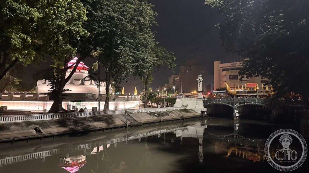
From the far bank of the moat, at night, the fort is a squat white octagon on a battered base, lit from the ground, with a tiered red-and-gold crown and a run of crenellated white wall going off to the left with the round merlons that are the signature of Bangkok’s wall. In front of it the water is dead flat and takes the whole thing upside down. To the right the Phan Fa Lilat bridge carries Ratchadamnoen across, with a white monument on the parapet and, on the far side, the gilded superstructure of a ceremonial pavilion. Behind, the flat slab of a modern building closes the view.
What you do not see is the part that was argued about. Behind the wall there is now lawn, and the reason it is empty is a decision, not an absence. The strip of ground between the wall and the moat held a settlement almost as old as the city, and it was the last of its kind: the architectural historian Chatri Prakitnonthakan described a layout found nowhere else on Rattanakosin Island, houses set so that every family opened onto a shared courtyard, with no fences between them, and a run of building types from early-Rattanakosin stilt houses to the carved wooden houses built when Siamese taste turned towards Europe. The Masterplan for the Conservation and Development of Krung Rattanakosin assessed it instead as a derelict slum fit for complete demolition, so that a park could open up the view of the monuments nearby — the fort itself, the city wall, the Loha Prasat, Wat Saket.
The fort today

The community that lived here
The fort is a monument and the ground around it was a place people lived. Both things are true, and the second one is what the site lost. The Bangkok Metropolitan Administration first asked the residents to leave, against compensation, in 1992; they refused, and spent the next twenty-five years arguing for a land-sharing arrangement that would have kept the houses and opened the ground. Conservationists and architects, Thai and foreign, argued the same case: that some of the wooden houses were themselves heritage, and that a living quarter inside the old wall was worth more than a lawn. Writing in 2012, Chatri argued that the community was an historic urban area that ought to have been conserved under the Washington Charter of 1987, a principle the Thai charter does not contain; the architect Graeme Bristol has framed the same case as one of cultural rights, and of planners refusing to recognise poor residents as part of the history of the place.
The demolition went ahead in stages. Twelve houses were pulled down in 2016, with one traditional wooden house left standing for its heritage value. The last families were ordered out by 25 April 2018; on 22 April the community held an event it called “Farewell Mahakan”. When the last houses came down, the head of architecture at Silpakorn University, Supitcha Tovivich, said that Bangkok had just lost one of its last links to its roots. The park opened that July and the Thai press that had followed the case reported it as poorly visited. The wall and the fort are intact, and the ground behind them is empty.
We record this because the fort cannot be described honestly without it, and because it is the question this kind of conservation always raises: what is being preserved, and for whom.
Practical information
- The fort is seen from outside and is not entered; the ground behind it, Mahakan Fort Park, is public, on Maha Chai Road opposite the Phan Fa end of Ratchadamnoen Klang.
- Phra Sumen, the other surviving fort, stands about two kilometres north-west at the river end of the same moat.
Sources
- The Nation (Thailand), “Mahakan Fort opens as public park”: the fort as one of 14 built by King Rama I on establishing Krung Rattanakosin as the capital of Siam in 1782, and only two surviving; the park opened on 23 July 2018 by the governor of Bangkok, nearly 8,000 square metres over 21 plots; 28 houses at the outset, 102 by 1992, the final 56 demolished in April 2018; the removal first set in motion in 1959
- The Nation (Thailand), on the dismantling of the last houses in April 2018: the two-decade campaign, the age of the community, and the comment of Supitcha Tovivich, head of architecture at Silpakorn University
- Fine Arts Department, Pom Mahakan and the city wall: evidence from the archaeological excavation: the construction under Rama I, the connection to the wall along Maha Chai Road, the octagonal plan and dimensions, the materials and roof, the gun emplacements, and the findings of the March 2020 excavation
- Princess Maha Chakri Sirindhorn Anthropology Centre (SAC), Database of archaeological sites in Thailand, record 773: the dating to about B.E. 2326, the fourteen forts of the city wall, the dimensions, the community that lived at the fort, and the Fine Arts Department registration of 22 November 1949 under the Ancient Monuments Act of 1934
- Chatri Prakitnonthakan, “The Rattanakosin Charter: The Thai Cultural Charter for Conservation”, Journal of the Siam Society, vol. 100 (2012): the site “below the city walls”; the house types and the communal layout; the four tunnel gates; the Masterplan’s assessment of the community and the case for conservation under the Washington Charter of 1987
- Graeme Bristol, Centre for Architecture and Human Rights — Rendered Invisible: Pom Mahakan, Bangkok, and Cultural Rights, The Siam Society under Royal Patronage: the cultural-rights argument
- Thai press coverage of the eviction (Bangkok Post, The Nation, Prachatai English, Khaosod English, 2016–2018): the 1992 start of the dispute, the BMA survey figures, the demolition of twelve houses in 2016, the order to leave by 25 April 2018 and the “Farewell Mahakan” event of 22 April, and the opening of the park in July 2018. These are press reports and are cited as such
- OpenStreetMap: coordinates of the fort and of the Phan Fa Lilat bridge
Record researched and written by Luigi De Marchi for Cultural Heritage Online, 2026.
Find it on the map
See this place and what’s around it →📷 Become a Cultural Heritage Online photographer
Share your photos of places: they stay published under your name as the author. The more they're seen, the more you get noticed — and soon a contest will reward the most appreciated photos.
Log in or sign up free to add a photoIs this page about you?
This page is read by travellers and heritage enthusiasts who find it on Google. Tell us how you are connected to this place and we will take it from there.