
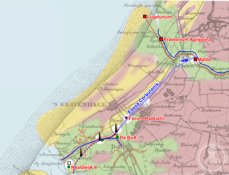
A Roman canal engineered around 50 AD to link the Meuse and Rhine rivers, this ambitious waterway served as both practical infrastructure and a means to occupy troops far from the dangers of the open sea.
At a glance
The Fossa Corbulonis was a Roman-era canal stretching approximately 23 Roman miles through what is now the Dutch delta. Constructed under Gnaeus Domitius Corbulo’s direction, it remained operational for more than two centuries.
History
Around 50 AD, the Roman military engineer Gnaeus Domitius Corbulo oversaw the canal’s excavation across the low-lying terrain between the Meuse and Rhine river mouths. Historians Tacitus and Cassius Dio both documented the project, recording its ambitious scale and strategic rationale. The canal served a dual purpose: it provided essential transportation infrastructure while keeping soldiers productively engaged, away from the perils of oceanic travel. The waterway remained in active use for roughly two centuries. By around 275 AD, sustained Frankish incursions led to the abandonment and depopulation of the region, bringing the canal’s operational life to an end.
What you see
No substantial remains of the canal are visible today. Archaeological and historical evidence suggests its course through the marshy delta landscape, where soft soil and water management presented significant engineering challenges for Roman construction techniques.
Cultural significance
The Fossa Corbulonis stands as testimony to Roman engineering ambition in frontier territories. It represents both practical military logistics and the broader Roman strategy of controlling waterways across occupied lands. The canal’s documented history illuminates how Rome adapted administrative and military resources to maintain control of distant provinces, even as external pressures ultimately forced withdrawal.
Key facts
- Country: Netherlands
- Constructed: c. 50 AD
- Engineer: Gnaeus Domitius Corbulo
- Length: approximately 23 Roman miles
- Connected: Meuse and Rhine river mouths
- In use until: c. 275 AD
- Coordinates: 52.0962°N, 4.4158°E
Practical information & getting there
The Fossa Corbulonis is an archaeological rather than a visitor site. Its original course lies beneath the contemporary Dutch landscape. Academic and local heritage institutions in the Rhine-Meuse delta region maintain records and interpretive materials about Roman engineering in the Netherlands.
Sources & resources
Find it on the map
See this place and what’s around it →📷 Become a Cultural Heritage Online photographer
Share your photos of places: they stay published under your name as the author. The more they're seen, the more you get noticed — and soon a contest will reward the most appreciated photos.
Log in or sign up free to add a photoIs this page about you?
This page is read by travellers and heritage enthusiasts who find it on Google. Tell us how you are connected to this place and we will take it from there.