
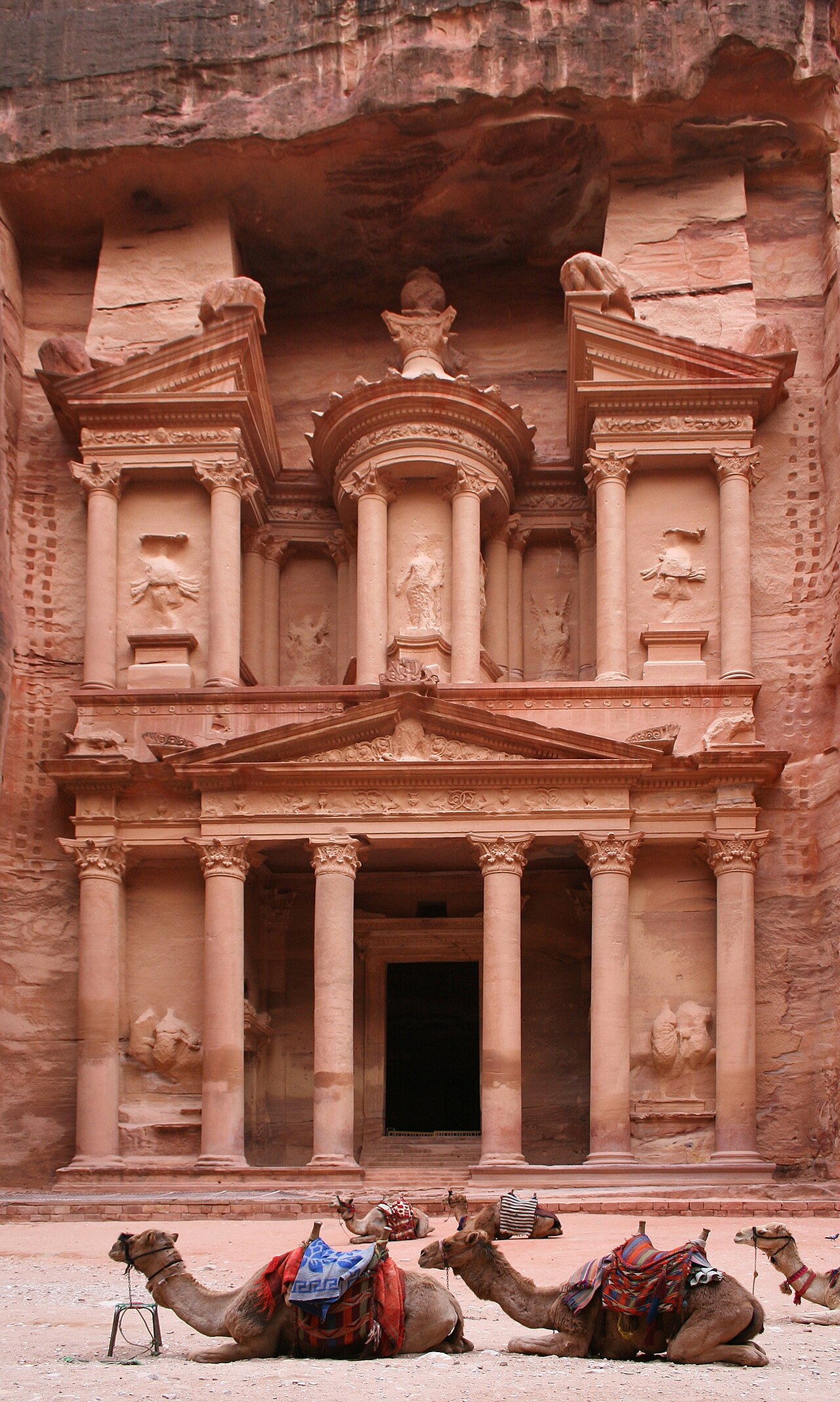
Petra (from the Greek “πέτρα” — “rock” — the Greek name given to the city; the Nabataeans who built it called it “Raqmu” in their Aramaic language; Petra is also identified with the Biblical “Sela” [Hebrew for “rock”], the fortified city of the Edomites that the Nabataeans conquered approximately 4th century BCE), inscribed by UNESCO in 1985 as Jordan’s first World Heritage site, is one of the most celebrated archaeological sites in the world and the outstanding monument of the Nabataean Kingdom (a pre-Islamic Arab kingdom that controlled the trade routes of the northwestern Arabian Peninsula, the Negev desert, and the Transjordan approximately 4th century BCE–106 CE, when it was formally incorporated into the Roman Empire as the Province of Arabia Petraea). Petra is famous above all for its extraordinary rock-cut architecture — a collection of more than 800 individual monuments (tomb facades, temples, colonnaded streets, a theatre, cisterns, and terraced gardens) carved directly from the rose-red, pink, and yellow sandstone of the Wadi Musa valley in what is now the Ma’an Governorate of southern Jordan, approximately 240 km south of Amman. The city’s position in the landscape (hidden in a network of sandstone canyons accessible primarily through the narrow “Siq” — a natural geological fissure approximately 1.2 km long, ranging from approximately 2 m to approximately 12 m in width, carved through the sandstone by a former watercourse) gave Petra a natural defensibility that allowed the Nabataean kingdom to resist Roman expansion for several centuries and made the city almost unknown to the European world until the Swiss explorer Johann Ludwig Burckhardt disguised himself as a Muslim pilgrim and entered the Siq in 1812 CE — the re-discovery of Petra that sparked 19th-century European archaeological interest in the Levant.
The Nabataean Kingdom, the Siq, and the Al-Khazneh facade Al-Khazneh Treasury · The Siq Gorge · Roman Colonnaded Street · Ad Deir Monastery · Amman 240 km · Aqaba 120 km
The Nabataeans were a nomadic Arabic-speaking people who first appear in the historical record in the 4th century BCE (a Greek papyrus from approximately 312 BCE describes a failed Seleucid military expedition against the Nabataeans, who at that point were still primarily pastoral nomads) and who gradually transitioned over the subsequent centuries from pastoral nomadism to sedentary urbanism, building a sophisticated commercial kingdom whose wealth derived from control of the overland trade routes connecting the Arabian Peninsula (the source of incense — frankincense and myrrh, produced from trees growing only in southern Arabia, the Horn of Africa, and the Dhofar region of Oman, and prized throughout the Mediterranean and Near Eastern worlds for religious ceremony and medicine), Gaza (the Mediterranean terminus of the incense route, where goods were sold into the Greek and Roman commercial networks), and the Gulf of Aqaba (the sea route to East Africa and India). The Al-Khazneh (“the Treasury” — the popular name given by the local Bedouin in the medieval period, who believed a treasure was hidden in the stone urn at the top of the facade — “khazneh” = “treasury” in Arabic) is the most famous of Petra’s rock-cut monuments: a facade approximately 40 m tall and approximately 28 m wide, carved directly into the vertical rose-red sandstone cliff at the end of the Siq gorge (the dramatic revelation of the Khazneh facade as visitors emerge from the narrow Siq into the wider space before the facade is one of the most celebrated arrival experiences in world travel). The facade is in two levels: the lower level (approximately 18 m tall) has a classical Greek-Roman architectural programme of six Corinthian columns supporting a broken pediment (a pediment split in the centre to allow a second tier above), with four carved figures in the intercolumnar niches; the upper level (approximately 22 m additional height) has three intercolumnar bays with a central circular tholos (a round temple) topped by the famous conical urn (approximately 4 m tall, long believed by the local Bedouin to contain Pharaoh’s gold — hence the bullet marks visible on the urn, from Bedouin attempts to shoot the gold out). The Khazneh is now generally dated to the reign of the Nabataean King Aretas IV (approximately 9 BCE–40 CE), the most powerful Nabataean ruler, based on stylistic comparison with dated Nabataean architectural works; its function was almost certainly a royal tomb (most of Petra’s rock-cut facades are tomb facades), though the interior space (a single chamber approximately 12 m × 12 m accessible through the central door of the lower facade) has no funerary inscriptions or burials in situ. The urban core of Petra (the Roman-period colonnaded street, the Temenos Gate, the Great Temple complex, and the commercial district) was built primarily in the 1st–2nd century CE following the Roman annexation of the Nabataean Kingdom as the Province of Arabia Petraea in 106 CE — paradoxically, the Roman annexation brought investment in urban infrastructure that gave Petra its most monumental architecture, even as it ended Nabataean political independence. The most spectacular single monument after the Khazneh is the “Ad Deir” monastery (a facade approximately 50 m wide × 45 m tall — actually slightly larger than the Khazneh, though less famous — carved at the summit of a mountain approximately 800 m above the main city basin, accessible via approximately 800 rock-cut steps from the main urban area, and dating probably to the 1st century CE Nabataean period).
Practical information
Petra is approximately 240 km south of Amman (approximately 2.5 hours by car on the Kings Highway or the Desert Highway) and approximately 120 km north of Aqaba (approximately 1.5 hours). The Petra Archaeological Park entrance is approximately 1 km east of the town of Wadi Musa (the modern town that has developed to serve Petra tourism), which has a full range of accommodation from budget guesthouses to international hotels. The park entrance fee (as of approximately 2024 CE: JD 50 for 1 day, JD 55 for 2 days, JD 60 for 3 days — fees are subject to change; check the Petra Development and Tourism Region Authority website for current prices) includes access to the entire archaeological park. The walk from the park entrance gate through the Siq to the Khazneh is approximately 1.2 km (the Siq) + approximately 50 m to reach the Khazneh facade — approximately 20–30 minutes on foot. The minimum visit to see the main monuments (Khazneh, colonnaded street, main temple area) requires approximately 4 hours; a full visit including Ad Deir (an additional 2 hours of hiking from the main area) requires a full day. The “Petra by Night” event (Monday/Wednesday/Thursday evenings — approximately 2 hours, candle-lit walk through the Siq to the Khazneh, with traditional music) is a popular addition. Best visiting months: March–May and September–November (summers are very hot; December–February can be cold and the site occasionally closes after rain).
Frequently Asked Questions
Who were the Nabataeans and what made their trade network so successful?
The Nabataeans (Greek: “Ναβαταῖοι”, “Nabataioi”; from the Arabic tribal name “Nabat” — possibly from the Semitic root meaning “to draw water” or “to discover water”, reflecting the Nabataean expertise in desert water management that was central to their commercial success) were an Arabic-speaking Semitic people who occupied the northwestern Arabian Peninsula, the Negev desert, and the Transjordan region from approximately the 4th century BCE. Their commercial success derived from three interconnected factors: (1) geographical position — the Nabataean territory controlled the most direct overland route between the incense-producing regions of southern Arabia (modern Yemen and Oman) and the Mediterranean markets at Gaza and Alexandria; the alternative sea route (around the Arabian Peninsula through the Red Sea and across the Mediterranean) was slower and less reliable than the overland route through the Nabataean-controlled Hejaz and Negev; (2) water management technology — the Nabataeans developed an extraordinary expertise in collecting and storing rainwater in the desert environment (the Negev averages approximately 100–200 mm of rain per year, falling in intense winter storms) through a network of cisterns, diversion channels, and storage pools that allowed them to maintain watering stations for their caravans across the waterless desert zones; recent archaeological mapping of the Negev has revealed thousands of Nabataean agricultural and water-management installations — the “runoff agriculture” system in which flash flood runoff is directed onto cultivated terraces and captured in cisterns, allowing the cultivation of wheat, olives, and vines in areas that would otherwise be too dry for agriculture; (3) political strategy — the Nabataeans maintained their commercial independence through a flexible combination of military resistance (successfully defeating several Roman and Seleucid military expeditions in the pre-Roman period) and diplomatic accommodation (accepting nominal Roman suzerainty while maintaining practical autonomy). The Nabataean trade was not limited to Arabian incense: the caravan goods also included bitumen from the Dead Sea (used as a preservative and sealant throughout the Mediterranean world), spices and silk from India (reaching the Nabataean ports on the Gulf of Aqaba via the sea route from India), and various agricultural products from the Nabataean-developed agricultural zones of the Negev and Transjordan. The Nabataean script (the Aramaic-based writing system used in Nabataean commercial and administrative texts) is the direct ancestor of the Arabic script — the Nabataean cursive evolved through the Syriac and then the pre-Islamic Arabic script into the classical Arabic calligraphic tradition, making the Nabataeans (though pre-Islamic) one of the founding contributors to the written culture of the Islamic world.
What is the current condition of Petra and what are the main conservation challenges?
Petra faces several severe conservation challenges that have been identified in the UNESCO World Heritage conservation reports and in the technical assessments of international archaeological teams working at the site: (1) water damage — the rose-red sandstone of Petra is relatively soft and highly porous, and both wind erosion (the aeolian erosion of the exposed facade surfaces, which removes surface material and produces the characteristic “honeycomb” weathering pattern visible on many older facades) and water damage (salt crystallisation in the pores of the sandstone, caused by alternating wetting by rainwater [which carries dissolved salts into the stone] and drying [which causes the salts to crystallise and expand, shattering the stone surface from the inside]) are progressively deteriorating the facade surfaces; (2) tourism pressure — Petra is one of the most visited archaeological sites in the Middle East (approximately 500,000–1,000,000 visitors per year in the pre-COVID period), and the physical pressure of foot traffic, the vibration from horse, donkey, and camel transport in the Siq and the main access routes, and the effects of the tourist-service infrastructure (shops, restaurants, and stabling within the archaeological park) are contributing to site deterioration; (3) development pressure — the modern town of Wadi Musa has expanded significantly around the Petra park boundary, and some development has encroached on the buffer zone; (4) flash flooding — the Siq was nearly destroyed by a flash flood in 1963 CE that killed 23 French pilgrims (the flood swept through the canyon without warning, filling it with water and rock debris in minutes — a known risk of the canyon environment, which has been partly mitigated by the construction of a diversion tunnel to redirect flash flood water around the Siq, but not eliminated). Conservation work at Petra has been conducted by multiple international teams including the Brown University Petra Archaeological Project (BUPAP), the American Center of Oriental Research (ACOR), the German team of the Free University of Berlin, and the French Mission Archéologique Française en Jordanie (MAFJ), in coordination with the Jordanian Department of Antiquities and the Petra Development and Tourism Region Authority (PDTRA). The UNESCO World Heritage site status gives international political support to conservation efforts and provides access to international technical expertise and (sometimes) funding, but the primary responsibility and funding for Petra’s conservation rests with the Jordanian government, which has made Petra’s conservation a national priority given the site’s central importance to Jordan’s international tourism revenue (Petra is consistently the single most important tourist attraction in Jordan).
EXCERPT: Petra, Jordan, UNESCO-inscribed 1985 — the Nabataean rock-cut city hidden in rose-red sandstone canyons: the 40-metre Al-Khazneh Treasury facade carved from solid sandstone at the end of the 1.2 km Siq gorge, 800+ monuments carved by an Arab trading kingdom that controlled the ancient world’s most lucrative trade routes between southern Arabia and the Mediterranean, and the Ad Deir Monastery reached by 800 rock-cut steps.
META: UNESCO World Heritage Sites near Petra Jordan: Quseir Amra Jordan 180 km north (UNESCO 1985), Um er-Rasas Jordan 130 km north (UNESCO 2004), Wadi Rum Jordan 70 km south (UNESCO 2011) — Petra Jordan UNESCO 1985, Nabataean Kingdom rose-red rock-cut city, Al-Khazneh Treasury Siq gorge, Ad Deir Monastery rock-cut sandstone, incense trade routes Arabia Mediterranean, Burckhardt rediscovery 1812.
Sources
- S1 — UNESCO World Heritage Centre — Petra (Ref. 326) — https://web.archive.org/web/20230601000000/https://whc.unesco.org/en/list/326/
- S2 — Petra Development and Tourism Region Authority (PDTRA) — https://www.visitpetra.jo/
Spotted an error? Write to editorial@culturalheritageonline.com and we correct it the same day.