
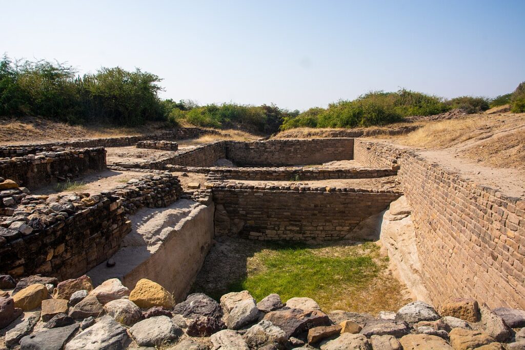
Dholavira: A Harappan City (ધોળાવીરા, inscribed by UNESCO in 2021), is one of the largest and most completely excavated cities of the Harappan (Indus Valley) Civilisation — located in the Rann of Kutch, Gujarat, on the island of Khadir Bet in the Great Rann of Kutch (a salt marsh island accessible from the mainland by a causeway, approximately 165 km from Bhuj), occupied from approximately 3000 BCE to approximately 1500 BCE (a span of approximately 1,500 years of continuous occupation, making it one of the longest continuously occupied Harappan settlements in the archaeological record). Dholavira (from “dholavira” meaning “white well” in Sindhi — a reference to the prominent step-wells that are a characteristic architectural feature of the site) covers approximately 100 ha of excavated urban area and demonstrates in exceptional completeness the sophisticated urban planning and water management technology of the Harappan civilisation: a grid-planned city with a fortified citadel (the upper town, residence of the ruling elite), a middle town (residence of merchants and artisans), and a lower town (craft-production and storage areas), all enclosed within massive perimeter walls of dressed stone masonry — a construction technology specific to Dholavira that distinguishes it from the more typical brick-constructed Harappan cities at Mohenjo-daro (Pakistan) and Harappa (Pakistan). The most remarkable single element of the Dholavira site is the water management infrastructure: the city is surrounded by approximately 16 water reservoirs (large cut-stone lined tanks connected to the city’s drainage network and to the seasonal rivers and rainwater catchment areas of the Khadir island), representing the most elaborate pre-modern urban water storage system known from any ancient city worldwide — a system designed to capture and store the limited and unpredictable monsoon rainfall of the hyper-arid Kutch environment for year-round civic water supply.
Dholavira’s Harappan urban landscape and the Kutch heritage corridor Dholavira citadel · 16 reservoirs · Rann of Kutch · Bhuj · Great Rann of Kutch — 0 to 165 km
The Dholavira archaeological site reveals through its excavations (conducted primarily by the Archaeological Survey of India under Dr. R.S. Bisht from 1990 to 2005, the most extensive Harappan city excavation conducted in India) a specific urban structure that has no parallel in the contemporary world of approximately 2500–2000 BCE: a planned city of approximately 50,000 inhabitants (estimated from residential area density) with a three-tier social hierarchy expressed in architectural form — the citadel (the highest point of the site, with massive stone fortification walls and rectangular bastions, approximately 48 m × 48 m towers at the corners, enclosing the ruling-class residential and administrative area), the middle town (a large enclosed area immediately adjacent to the citadel, with medium-sized buildings and craft-production areas, enclosed by its own fortification wall), and the lower town (the largest area, with smaller residential units, storage facilities, and the major craft-production zones for pottery, jewellery, and textiles). The Dholavira site is unique within the Harappan world for two specific features: (1) its construction material — while the canonical Harappan cities (Mohenjo-daro, Harappa) used kiln-fired brick as the primary construction material, Dholavira is built predominantly of locally quarried limestone (the Khadir island has excellent limestone outcrops) in courses of dressed stone, a technique that has preserved the site’s architecture in more durable condition than the brick-constructed cities and also demonstrates the Harappan craftsmen’s ability to adapt their urban technology to local geological conditions; (2) the discovery of the “Dholavira inscription” — a large sign-board of ten Harappan script symbols (the largest known Harappan inscription, approximately 3 m × 0.37 m, found fallen near the northern gateway of the citadel and interpreted as a gateway sign, perhaps naming the city or identifying the ruler) which, although the Harappan script remains undeciphered, represents the most dramatic epigraphic discovery of the entire Harappan civilisation and is exhibited as a replica at the site museum. The water management system of Dholavira (the 16 reservoirs totalling approximately 3.5 km of reservoir perimeter within the city enclosure, connected by a network of stone-lined channels to the natural drainage of the Khadir island and supplemented by a system of dams and diversions in the seasonal rivers to the north and east of the city) represents an engineering achievement remarkable for 2500 BCE: the storage capacity of the reservoirs is estimated at approximately 300,000 cubic metres — sufficient to supply approximately 50,000 people with 6 litres per person per day for approximately 1,000 days, a reserve that would allow the city to survive approximately 3 years of complete monsoon failure. The engineering rationale for this extraordinary water storage capacity is the specific location of Dholavira in the hyper-arid Kutch environment — the Rann of Kutch (the salt marsh of Kutch, one of the driest regions in India with annual rainfall of approximately 300–400 mm concentrated in the monsoon months of July–August) makes water storage a survival imperative, and the Harappan engineers who designed the Dholavira reservoir system built redundancy into the water supply that protected the city against the droughts that may have contributed to the eventual decline of the Harappan civilisation.
Bhuj (the Kutch district headquarters, approximately 165 km from Dholavira, the base for the site visit) is the primary regional heritage centre — the city was largely destroyed in the 2001 Bhuj earthquake (Mw 7.7, the deadliest earthquake in Indian history since 1950, with approximately 20,000 deaths) and has been reconstructed with a specific emphasis on preservation of its pre-earthquake heritage buildings (the Prag Mahal palace, the Aina Mahal “Palace of Mirrors”, and the traditional crafts of the Kutchi community — Rogan art, Ajrakh block-printing, and the mirror-work embroidery of the Ahir and Mutwa communities).
Practical information
Dholavira is approximately 165 km north of Bhuj by road (approximately 3.5–4 hours via the Bhuj–Dholavira road through the Kutch desert landscape). By road from Bhuj: hire a car or taxi (no public bus direct to Dholavira; state bus goes to Khavda, approximately 35 km from Dholavira, requiring a local jeep for the final section). Bhuj is accessible by train from Ahmedabad (Ahmedabad–Bhuj daily train, approximately 6–7 hours) or by flight (Bhuj Airport, BHJ, with connections to Mumbai). The Dholavira site is managed by the Archaeological Survey of India. The site is open daily 07:00–17:00 (last entry 16:00). Admission fees apply (Indian and foreign visitor rates). A site museum at Dholavira exhibits excavation finds (pottery, beads, tools, and the replica of the Harappan inscription sign-board). Licensed guides are available at the entry gate (strongly recommended — the scale of the site and the interpretation of the urban structure require expert guidance). Visiting time: approximately 3–4 hours for a thorough visit to the citadel, middle town, lower town, and the reservoir network. The Rann of Kutch White Desert (the Great Rann, accessible from Dholavira or from the Rann Utsav tourist circuit based at Dhordo village, approximately 100 km from Dholavira) is the natural complement — the vast salt flat of the Rann is at its most spectacular October–March (the dry season when the surface is white with salt crystals and the horizon appears infinite). The Rann of Kutch is famous for the Wild Ass Sanctuary (Indian Wild Ass, the last wild population in Asia, approximately 6,000 animals in the Little Rann of Kutch, approximately 150 km from Dholavira). Best visiting months: October–March (temperatures 15–30°C, dry, road access reliable).
Frequently Asked Questions
What was the Harappan (Indus Valley) Civilisation and why did it decline?
The Harappan Civilisation (also called the Indus Valley Civilisation, IVC, or Indus-Saraswati Civilisation in Indian nationalist historiography) was the most extensive of the world’s four primary Bronze Age urban civilisations (alongside Mesopotamia, Egypt, and China) — occupying approximately 1.5 million km² of the northwestern Indian subcontinent (covering present-day Pakistan, northwestern India, and southeastern Afghanistan) during its mature phase from approximately 2600 to 1900 BCE, with an estimated population of 1–5 million people in approximately 1,000 settlements ranging from small farming villages to major urban centres. Dholavira is the fifth-largest known Harappan city (after Mohenjo-daro in Sindh/Pakistan, Harappa in Punjab/Pakistan, Rakhigarhi in Haryana/India, and Ganeriwala in Pakistan) and the largest in India. The key features that define the mature Harappan civilisation across its full geographic range are: grid-planned urban layout (the streets of Harappan cities are oriented on cardinal directions, with main streets approximately 9–10 m wide and subsidiary lanes approximately 3–4 m wide, creating a consistent grid that is visible at both major sites and smaller towns); a standardised system of weights and measures (the Harappan weight system — based on a binary progression of units: 1, 2, 4, 8, 16, 32, 64 — is identical across all Harappan sites regardless of the distance between them, indicating a shared metrology that is the strongest evidence for an interconnected economic system); the Harappan script (approximately 400 symbols used in short inscriptions on seal stones, pottery, and copper tablets — the script remains completely undeciphered despite nearly a century of attempts, because there is no bilingual text like the Rosetta Stone to provide a translation key and the language of the Harappan people is unknown); and the sophisticated urban sanitation (all Harappan cities have a covered brick drain system connected to individual household drains, the most advanced urban sanitation system before the Roman Empire). The decline of the Harappan civilisation (approximately 1900–1500 BCE) is one of the most studied problems in archaeology and was until the 2010s typically attributed primarily to the “Indo-Aryan migration” (the arrival of the Indo-European speaking groups that brought Sanskrit, the Vedic religious tradition, and ultimately the foundational elements of the Hindu cultural tradition to South Asia) or to a single climatic catastrophe. The current scholarly consensus (based on climate proxy data from stalagmites, lake sediments, and marine cores from the Arabian Sea) attributes the decline primarily to a multi-century weakening of the South Asian Monsoon beginning approximately 2200–2100 BCE (the “4.2 Kiloyear Event” in paleoclimatology — a globally significant drought event that has been associated with the collapse of the Old Kingdom in Egypt, the Akkadian Empire in Mesopotamia, and the Harappan civilisation in South Asia simultaneously, suggesting a global climatic forcing mechanism). The monsoon weakening reduced agricultural productivity across the Harappan domain and would have made the elaborate water-management systems of cities like Dholavira (designed for drought resilience) insufficient against a sustained multi-century drought of this severity.
Why is the Harappan script at Dholavira particularly significant?
The “Dholavira sign-board” (the official Archaeological Survey of India designation for the large Harappan inscription discovered in the rubble fill of the northern gate of the Dholavira citadel during the 1997–98 excavation season) is the single most dramatic epigraphic discovery from the Harappan civilisation since the initial identification of the script in the 1920s — for several specific reasons: (1) Its size. The sign-board is approximately 3 m long × 37 cm high, composed of ten large symbols carved or inlaid (the original material has been debated — the white material that filled the carved stone channel of each symbol has been variously identified as gypsum, calcite, or white-painted wood inlay; the symbols themselves are preserved as carved stone channels in a fragment of dressed stone) — making it approximately 20 times larger than any other known Harappan inscription. The largest known Harappan “seals” (the square stamp seals used for trade and administration) carry inscriptions of typically 3–8 symbols, each approximately 1–3 cm in size; the Dholavira sign-board symbols are approximately 30–40 cm each. (2) Its location. The sign-board was found near the main northern gateway of the Dholavira citadel — the principal entrance to the highest-status area of the city, suggesting that the inscription was a public sign (a city name? a royal proclamation? a religious dedication?) placed at the city’s most visible ceremonial entrance. This “public sign” function is unique in the Harappan epigraphic record: all other Harappan inscriptions are on small objects (seals, tablets, pottery) that were personal possessions or trade markers; the Dholavira sign-board is the only known Harappan inscription that appears to have been a large-scale public monument designed for visibility at a distance. (3) Its undeciphered status. Despite the dramatic discovery of the Dholavira sign-board and intensive subsequent analysis of its ten symbols in relation to the existing Harappan script corpus, the inscription remains completely undeciphered. The Harappan script has approximately 400 distinct signs (the count varies by analysis method between 400 and 700, depending on how sign variants are counted), with individual Harappan inscriptions typically consisting of 4–8 signs; the Dholavira sign-board has 10 signs in a single row, which is the longest known Harappan inscription by sign count. Various decipherment attempts since the 1920s have proposed Dravidian, Indo-Aryan, and other linguistic affiliations for the Harappan language; none has achieved scholarly acceptance. The specific challenge of decipherment is the absence of any bilingual text that could provide a translation key (the Rosetta Stone equivalent for Harappan would require finding an inscription in both Harappan and a known ancient language, which has not occurred despite the extensive geographical range of Harappan trade contacts with Mesopotamia and Persia where cuneiform texts are available). The continued undecipherability of the Harappan script means that the Dholavira sign-board, despite its drama and scale, cannot be “read” — a fact that reinforces the mystery of the Harappan civilisation as the only major Bronze Age urban civilisation whose language and writing system remain entirely unknown.
EXCERPT: Dholavira, UNESCO-inscribed in 2021, is one of the largest Harappan (Indus Valley) Civilisation cities (2500–1500 BCE) in Gujarat’s Rann of Kutch — a limestone-built city with 16 interconnected reservoirs storing 300,000 cubic metres of water, the largest known Harappan inscription (undeciphered, 3 m long), and sophisticated urban planning 4,500 years before modern water management.
META: UNESCO World Heritage Sites near Dholavira Kutch Gujarat India: Champaner-Pavagadh Archaeological Park (UNESCO 2004), Historic City of Ahmadabad (UNESCO 2017), Rani-ki-Vav Patan (UNESCO 2014) — Harappan Indus Valley Civilisation India Dholavira Bhuj Kutch, Bronze Age water management, Harappan script undeciphered inscription.
Sources
- S1 — UNESCO World Heritage Centre — Dholavira: a Harappan City (Ref. 1649) — https://web.archive.org/web/20230601000000/https://whc.unesco.org/en/list/1649/
- S2 — UNESCO World Heritage Centre — Statement of Outstanding Universal Value (Ref. 1649) — https://whc.unesco.org/en/list/1649/
Spotted an error? Write to the editors and we correct it the same day.