
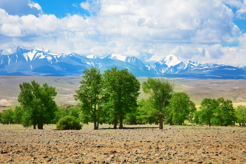
The Golden Mountains of Altai, inscribed by UNESCO in 1998, protect 1,611,457 hectares of the Altai Republic in south-central Siberia — the highest and most biodiversity-rich mountain system in Siberia — across three contiguous protected areas: Altaisky Nature Reserve (zapovednik, 871,206 ha, on the shores of Teletskoye Lake), Katunsky Nature Reserve (zapovednik/biosphere reserve, 151,638 ha, centred on the Belukha massif), and the Ukok Quiet Zone (255,044 ha, a highland plateau zone on the border of Russia, China, Mongolia, and Kazakhstan). The inscription protects the full elevation gradient of the Altai — from the steppe at 600 metres to the perpetual glacier at 4,506 metres on Belukha Mountain (the highest summit in Siberia) — supporting populations of endangered large mammals including the snow leopard (Panthera uncia), Altai argali wild sheep (Ovis ammon ammon), Siberian ibex (Capra sibirica), and brown bear (Ursus arctos).
Belukha, Teletskoye Lake and the Altai mountain landscape Belukha Mountain 4,506 m · Teletskoye Lake · Ukok Plateau Ice Maiden — within the inscription
Belukha Mountain (4,506 m), the highest peak of the Altai system and the highest point in Siberia outside the Kamchatka volcanoes, is the central feature of the Katunsky Nature Reserve and biosphere reserve. Belukha is the source of the Katun River (which flows northwest to join the Ob, ultimately reaching the Arctic Ocean), and its twin summits (the East Summit 4,506 m and the West Summit 4,440 m, separated by a col at approximately 4,100 m) are perpetually glacier-covered; the Katunsky and Akkemsky glaciers on Belukha’s flanks are among the largest valley glaciers in the Altai system. Belukha has spiritual significance for several Central Asian traditions: the mountain is a sacred site of the Altai indigenous people (Altaians, or Altai-Kizhi), who consider it the dwelling of the White Burkhan deity; it was identified by the Russian artist, writer, and philosopher Nicholas Roerich (1874–1947 CE) in his 1926 Altai-Himalaya expedition diaries as the location of Shambhala (the mythical hidden kingdom of Tibetan Buddhist tradition); and it is regarded in the Russian New Age tradition as one of the world’s sacred mountains. The area around Belukha’s base (the Akkemskoe and Yarlu lakes, the Ak-Kem river valley, and the Karakol lakes circuit on the reserve’s eastern flank) is accessible via multi-day trekking routes from the town of Ust-Koksa (approximately 120 km from Belukha Base Camp by 4WD track and hiking trail) and is the most popular wilderness trekking destination in the Altai Republic. Teletskoye Lake (Altyn Köl — “Golden Lake” in the Altai language, 223 km², maximum depth 325 m — the second-deepest lake in Russia after Baikal) lies entirely within the Altaisky Nature Reserve and is the reserve’s primary ecosystem centrepiece: fed by 70 rivers (the largest being the Chulyshman River from the south) and drained northward by the Biya River, the lake holds approximately 40 cubic kilometres of water in a deep basin surrounded by mountains rising 2,000–2,500 metres above the lake surface. The Altaisky Reserve was established in 1932 CE and is one of Russia’s oldest nature reserves; its role as a protected lake catchment for Teletskoye’s exceptional water quality (the lake is a pristine source of the freshwater that feeds the Ob River system) is among its primary ecological functions.
The Ukok Plateau (Ukok Plateau Quiet Zone, 2,550 m elevation, in the extreme south of the Altai Republic on the border with China, Mongolia, and Kazakhstan) is the most archaeologically significant component of the UNESCO inscription — and also the most politically contentious. The plateau’s archaeological significance rests on the exceptional preservation conditions of its high-altitude permafrost: the permanently frozen subsoil beneath the plateau’s burial mounds (kurgans) of the Pazyryk culture (an Iron Age Scythian-related nomadic people, approximately 600–300 BCE) preserved organic materials — clothing, wooden objects, tattooed human skin, horses with their saddles and harness — that have not survived in any other Scythian context. The most celebrated discovery from the Ukok Plateau is the “Ice Maiden” or “Princess of Ukok” (known in Russian as Altaiskaya Printsessa, the Altai Princess) — a mummified woman of approximately 25 years of age, tattooed on both arms with elaborate animal-style designs (a deer with Altai griffon antlers, a snow leopard, argali sheep), discovered in 1993 CE by the archaeologist Natalia Polosmak of the Novosibirsk Institute of Archaeology in a kurgan at the centre of the plateau. The woman was accompanied by six sacrificed horses, her personal belongings, and high-status grave goods consistent with a shaman or priestess of the Pazyryk elite, dating to approximately 2,500 years ago. The Ukok Ice Maiden is now housed in the Gorno-Altaisk Republican Museum in the capital of the Altai Republic; her discovery and removal from the plateau became a focus of indigenous Altai protest, with Altaian shamans attributing the 2003 Altai earthquake (7.3 magnitude, the largest earthquake in the Altai Republic’s recorded history) to the disturbance of the Ice Maiden’s burial — a controversy that has shaped subsequent debates about indigenous rights, archaeological ethics, and World Heritage management in the Altai Republic.
Mongolian and Kazakh Altai connections: a cross-border heritage landscape Mongolian Altai Petroglyphs UNESCO · Altai Tavan Bogd Mongolia · Kazakh Altai mountains — 100 to 400 km
The Golden Mountains of Altai World Heritage Site is part of a transboundary mountain system that includes significant UNESCO inscriptions in neighbouring Mongolia: the Petroglyphic Complexes of the Mongolian Altai (UNESCO 2011) in Bayan-Ölgii Province, Mongolia — approximately 150–200 km south of the Russian Altai Ukok Plateau boundary — protect approximately 10,000 Bronze Age and Iron Age rock engravings in the Tsagaan Salaa and Baga Oigor river valleys that are directly contemporaneous with the Pazyryk culture materials found at Ukok. The Pazyryk culture itself was a broadly distributed Iron Age nomadic complex extending from the southern Altai Republic through the Mongolian Altai into western Mongolia; the Ice Maiden of the Ukok Plateau and the tattooed mummies found at the Pazyryk kurgan group in the Altai Republic’s Ulagan District (the type site of the Pazyryk culture, excavated by Soviet archaeologist Mikhail Gryaznov in 1929–1936 CE) are cultural relatives of the Scythian nomads whose burial mounds extend from the Black Sea steppe to Mongolia. The Belukha mountain massif is also culturally connected to the Mongolian and Kazakh traditions: Belukha is the northernmost peak of a mountain system that continues south into the Mongolian Altai (Tavan Bogd, “Five Saints” — the highest massif of Mongolia at 4,374 m, approximately 100 km south of Belukha) and further south into the Chinese Xinjiang Altai range and the Kazakhstani Altai. The shared shamanic and nomadic heritage of the Russian, Mongolian, Kazakh, and Chinese Altai peoples — all members of the broad Turkic-Mongolian cultural tradition — gives the Golden Mountains inscription its significance not only as a natural World Heritage site but as a landscape of living cultural practice that transcends the political borders of the four states sharing the Altai mountain system.
One Hundred Kilometres northwest of Teletskoye Lake by road, the city of Gorno-Altaisk (population approximately 65,000, the capital of the Altai Republic) is the primary access hub for the UNESCO inscription. The National Museum of the Republic of Altai (Anokhin National Museum) in Gorno-Altaisk holds the collection of Pazyryk culture artefacts from the Ukok Plateau and other sites, including the Ice Maiden (displayed in a temperature-controlled glass sarcophagus in a specially constructed room), and provides the essential cultural context for understanding the inscription’s archaeological dimension alongside its natural heritage. Gorno-Altaisk is served by a small airport (flights from Novosibirsk and Moscow Domodedovo in summer season) and by road from Novosibirsk (500 km northwest on the Chuisky Highway, approximately 6–7 hours). The Chuisky Highway (Chuysky Trakt, M-52) — which runs the length of the Altai Republic from Biysk on the Biya River south to Mongolia through the Chulyshman Valley and the Ukok Plateau — is one of the most scenically spectacular roads in Russia, included by National Geographic in its 2009 list of the ten most beautiful highways in the world; the highway passes through the Katun river gorge, the Semia and Ongudai steppe basins, and ascends to the Ukok Plateau at 2,550 m before crossing into Mongolia.
Practical information
The Golden Mountains of Altai inscription covers three protected areas, each with different access conditions. Altaisky Nature Reserve (Teletskoye Lake zone): accessible from the town of Artybash at the northern end of Teletskoye Lake (120 km south of Biysk by road); boat excursions on the lake to the Altaisky Reserve southern shore are organised from Artybash in summer (June–September); permit required for entry into the strict reserve zone (obtainable at the Artybash ranger station); tourism infrastructure (small hotels and guesthouses) in Artybash and Iogach villages. Katunsky Nature Reserve (Belukha zone): accessible via Ust-Koksa (250 km south of Gorno-Altaisk via the Chuisky Highway turnoff) then 4WD track to the Akkem river valley base camp (approximately 120 km from Ust-Koksa, approximately 5–7 hours in summer); the Akkem-Belukha route is a 2–3-day hike from the road head to base camp under Belukha; all trekking in the Katunsky Reserve requires advance permit (free, obtainable online from the reserve website). Ukok Plateau Quiet Zone: accessible via the Chuisky Highway south from Kosh-Agach to the plateau (approximately 100 km, last 50 km on dirt track requiring 4WD); travel on the Ukok Plateau requires a border zone permit (the plateau is within the Russian border control zone with Mongolia, Kazakhstan, and China; permits obtainable from the FSB border service in Kosh-Agach with 1–2 weeks advance). Best season for all zones: July–August (alpine wildflowers in bloom, maximum trail accessibility, glacier walks accessible); snow can occur at high elevation in any month.
Frequently Asked Questions
Who was the Ice Maiden of the Ukok Plateau and why is her discovery controversial?
The Ice Maiden of the Ukok Plateau (Altaiskaya Printsessa — “Altai Princess” — in Russian) is a mummified woman of approximately 25 years of age, discovered in 1993 CE by archaeologist Natalia Polosmak (Novosibirsk Institute of Archaeology, Russian Academy of Sciences) in a wooden larch log burial chamber beneath a kurgan (burial mound) at Ak-Alakha 3, at the centre of the Ukok Plateau, Altai Republic. The woman was preserved by the permafrost beneath the kurgan for approximately 2,500 years in an exceptional state of soft-tissue preservation: her skin, hair (dyed auburn and arranged in an elaborate braided style), and extensive tattoos on both arms were intact. The tattoos — complex animal-style designs executed in deep blue ink (consistent with woad or a mineral pigment applied by pricking), covering the left arm from shoulder to wrist — depict a composite fantastical creature (a deer with griffin-like antlers and curling hooves, a snow leopard, and an Altai mountain argali) in the Pazyryk style characteristic of the Scythian-related nomadic art tradition of the 6th–3rd centuries BCE. The woman was interred with six sacrificed horses (fully harnessed with decorated leather saddles and bridles), a small mirror, combs, a horse-whip, and the remains of a meal — grave goods consistent with a high-status woman of the Pazyryk culture, possibly a shaman or priestess. The controversy over the Ice Maiden’s discovery centres on three issues: first, the ethics of removing a revered ancestor from her resting place (Altaian indigenous organisations and shamanic practitioners consider the Ukok Plateau a sacred landscape and the Ice Maiden a protector spirit whose disturbance caused the 2003 Chuisky earthquake); second, the adequacy of the museum’s conservation of the mummy (transport in a poorly insulated container led to partial thawing and biological damage to the specimen; the subsequent restoration was funded by the Altai Republic government at considerable cost); and third, the question of ownership and display rights (the Altaian indigenous organisations have demanded the return of the Ice Maiden to the Altai Republic — she is now displayed in Gorno-Altaisk — and her eventual reburial on the Ukok Plateau, a demand the Russian Academy of Sciences has resisted on scientific grounds).
What is the snow leopard population of the Altai and how is it protected?
The Altai Republic hosts one of the most important snow leopard (Panthera uncia) populations in Russia: a population estimated at approximately 60–80 individuals in the Altai Republic, with an additional 10–20 in the adjacent Tyva Republic, forming part of the approximately 4,000–6,500 snow leopards estimated to remain globally across 12 countries of the Himalayas and Central Asia (the IUCN classifies the snow leopard as Vulnerable on the Red List). The snow leopard’s habitat in the Golden Mountains of Altai inscription — specifically the rocky high-altitude terrain of the Katunsky Reserve, the Ukok Plateau, and the Altaisky Reserve’s eastern highland zone — represents the northernmost significant snow leopard habitat in the world, at the edge of the species’ climatic tolerance for subarctic winters. Snow leopard monitoring in the Altai Republic uses camera traps, GPS-collar telemetry (approximately 10–15 individuals have been fitted with GPS collars by WWF Russia and the Snow Leopard Trust’s Altai programme over the past decade), and genetic analysis of hair and scat samples collected along snow leopard scent-marking routes. The primary threats to the Altai snow leopard population are prey depletion (argali wild sheep and ibex populations have declined significantly due to poaching; snow leopards shift to livestock predation when wild prey is scarce, creating conflict with herders), retaliatory killing by herders protecting livestock, and transboundary migration risk (snow leopards move between Russia, Mongolia, Kazakhstan, and China along mountain corridors with varying levels of legal protection in each country). The Golden Mountains of Altai inscription’s contribution to snow leopard conservation is primarily through the strict protection of the core habitat in the zapovednik zones, which provides a secure breeding area for the Altai population; the transboundary connectivity with Mongolian and Kazakhstani protected areas is addressed through bilateral cooperation agreements but lacks the formal UNESCO transboundary World Heritage Site designation that would provide the strongest legal framework for cross-border species conservation.
What is the Chuisky Highway and why is it considered one of the world’s most scenic roads?
The Chuisky Trakt (Chuysky Highway, Federal Highway M-52) is a 968-kilometre road running from Novosibirsk in western Siberia south to the Mongolian border at Tashanta, passing through the heart of the Altai Republic along the Katun River gorge, the Chemal, Ongudai, and Kosh-Agach steppe basins, and ascending via the Chike-Taman and Seminsky passes to the Ukok Plateau. The highway’s scenic reputation derives from the exceptional sequence of landscape types it traverses within its 600 km in the Altai Republic: the Katun River gorge south of Biysk (canyon walls up to 700 metres high, the turquoise glacial meltwater river visible far below the road), the Onguday steppe valley (a broad flat basin ringed by snow peaks, dotted with kurgan burial mounds of the Scythian and Pazyryk cultures), the Aktash red sandstone cliffs and the Chulcha tributary valley (site of the Uchar Waterfall, the largest waterfall in Siberia at 160 metres, accessible by a 10-km hike from the Chuisky Highway), and the final ascent to the Ukok Plateau through the Sailyugem ridge (2,500–3,200 m elevation, with views to the Mongolian Tavan Bogd massif). The Chuisky Highway follows the route of the ancient Great Silk Road spur that connected the Russian Altai to Central Asian and Chinese trade networks via Mongolia — the same route documented in Chinese Tang Dynasty records (7th–10th centuries CE) as the northern branch of the Silk Road through “Altai territory.” The highway was first mapped by Russian Tsarist surveying expeditions in the 18th century and paved to its current state in the Soviet period; approximately 600 km of the route within the Altai Republic passes through or adjacent to the UNESCO World Heritage inscription boundaries, making it the most accessible overland route to the Golden Mountains heritage sites from the Russian rail network (the nearest major railway station is Biysk, approximately 100 km north of the Altai Republic boundary).
EXCERPT: Golden Mountains of Altai (UNESCO 1998) — Belukha Mountain (4,506 m, highest peak in Siberia), the tattooed Ice Maiden preserved for 2,500 years in Ukok Plateau permafrost, and snow leopard habitat in Russia’s Altai Republic — at the meeting point of Russia, Mongolia, Kazakhstan, and China.
META: UNESCO World Heritage Sites near the Golden Mountains of Altai Russia: Petroglyphic Complexes of the Mongolian Altai (UNESCO 2011) 200 km south, Altai Tavan Bogd Mongolia 100 km south — transboundary Inner Asian heritage landscape from Scythian burial mounds to Silk Road mountain corridors.
Sources
- S1 — UNESCO World Heritage Centre — Golden Mountains of Altai (Ref. 768) — https://web.archive.org/web/20230601000000/https://whc.unesco.org/en/list/768/
- S2 — Altai State Nature Biosphere Reserve — https://altai-reserve.ru/
Spotted an error? Write to the editors and we correct it the same day.