
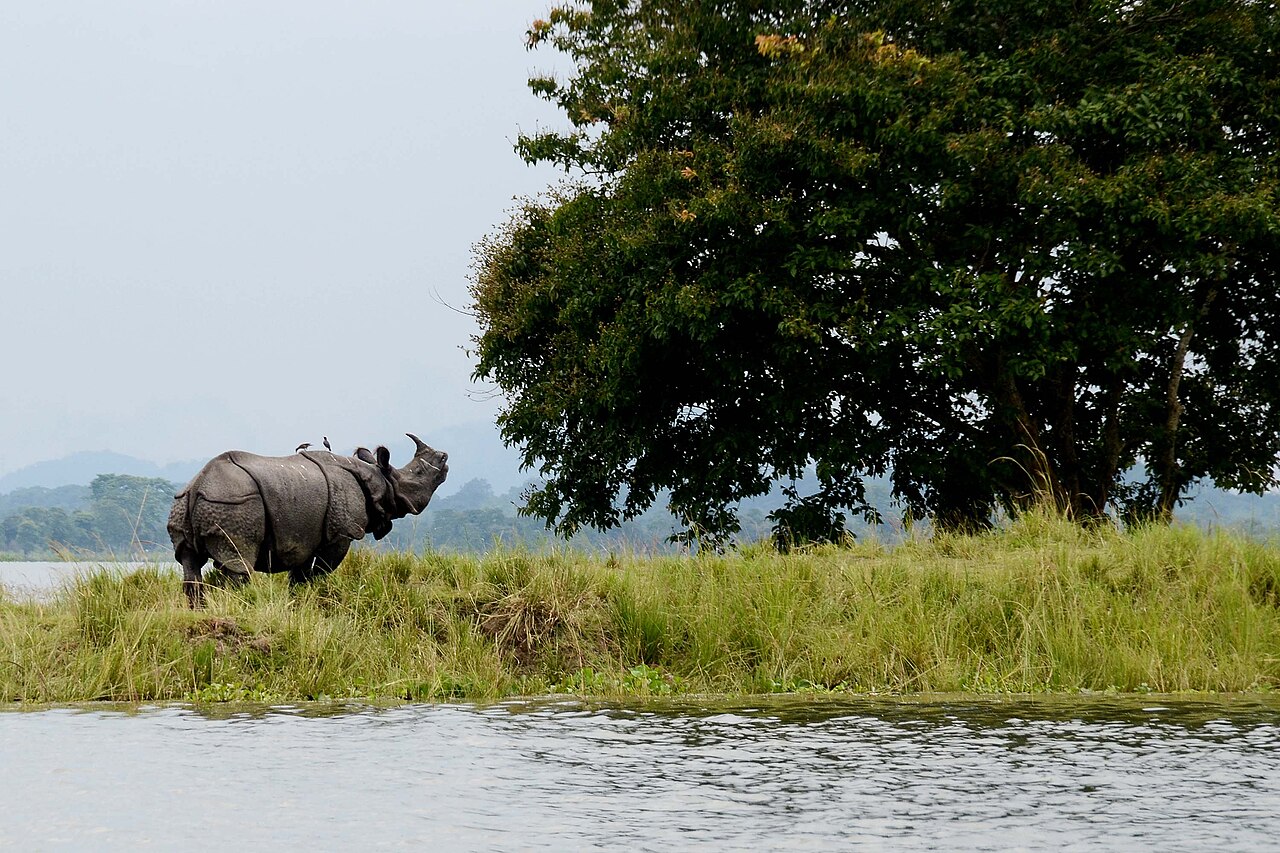
Kaziranga National Park (কাজিৰঙা ৰাষ্ট্ৰীয় উদ্যান), inscribed by UNESCO in 1985, is the most important single site for the conservation of the Indian one-horned rhinoceros (Rhinoceros unicornis, the greater Indian rhinoceros) in the world — a national park of approximately 1,078 km² in the floodplain of the Brahmaputra river in Assam, northeastern India, that currently holds approximately 2,613 rhinoceros individuals (2018 census), representing approximately 70% of the world’s total remaining wild population of the species, in a habitat of tall elephant grass, seasonal marshes, and semi-evergreen forest subject to annual flooding by the monsoon Brahmaputra that is both the park’s greatest ecological challenge and its most essential ecological driver. Kaziranga also holds one of the highest densities of the Bengal tiger (Panthera tigris tigris) in the world (approximately 35 tigers per 100 km², compared to a typical reserve density of 10–15 tigers per 100 km²), a population of Indian elephants (Elephas maximus indicus) numbering approximately 1,040 individuals (2017), large herds of Eastern swamp deer (Rucervus duvaucelii ranjitsinhi — a subspecies found only in Assam and considered endangered), and large herds of wild water buffalo (Bubalus arnee). The park is bisected by the national highway NH 37 (now NH 715), creating a wildlife crossing challenge as animals, particularly rhinoceros and elephants, cross between the core park area and the Karbi Anglong hills to the south during the monsoon flooding season — the Assam government has implemented speed restrictions and underpass structures to reduce vehicle strikes during the monsoon migration.
Kaziranga’s rhinoceros conservation landscape and the Assam heritage corridor Central Range · Western Range · Eastern Range · Orang NP · Manas NP — 0 to 150 km
Kaziranga National Park is divided into four administrative ranges (Central/Kohora, Western/Bagori, Eastern/Agoratoli, and Burapahar), each with separate entry points and wildlife viewing infrastructure. The Central Range (Kohora, at the park’s central entry point on NH 715, 217 km from Guwahati) is the most visited and provides the highest probability of rhinoceros sightings — the open grassland terrain in the Central Range allows clear views at distances that the denser forest of the Eastern Range does not. The Western Range (Bagori) has the park’s highest rhino density per unit area (approximately 1.5 rhinos per km²). Wildlife viewing is conducted from two platforms: elephant-back safari (early morning, 05:30–07:30, the most intimate wildlife viewing experience available in any Indian park — the height of the elephant allows viewing over the 3–4 metre tall elephant grass; rhinoceros habituate readily to mahout-managed elephants and can be approached closely), and jeep safari (morning and afternoon slots). The annual Brahmaputra monsoon flood (June–September, when approximately 70% of the park area is inundated) forces the rhinoceros, elephants, and tigers onto the raised hillocks (Plateaus within the grassland) and to the Karbi Anglong hills — both of which involve animals crossing NH 715. During severe flood years (2012, 2017 were particularly devastating), significant numbers of rhinos have been found drowned or swept downstream to human-populated areas, requiring rescue operations by Forest Department staff and wildlife NGOs. The paradox is that the flooding, though dangerous for individual animals in extreme flood years, is ecologically essential — it deposits nutrients, maintains the grassland ecosystem by preventing woody plant encroachment, and fills the seasonal marshes (beels) that form the core rhino and bird habitat.
Orang National Park (UNESCO tentative list — the “Mini Kaziranga”, approximately 79 km² on the north bank of the Brahmaputra, 100 km west of Kaziranga, with approximately 100 rhinos and a significant tiger population) and Manas National Park (UNESCO World Heritage 1985 — approximately 500 km² in the Assam-Bhutan border zone, 175 km west of Kaziranga — a Biosphere Reserve and Tiger Reserve with a smaller rhino population supplemented by reintroduction programme) form the “Assam Tiger-Rhinoceros Landscape” with Kaziranga — the connected system of protected areas in Assam that together represent the last viable wild population of the Indian one-horned rhinoceros. Manas NP was removed from the UNESCO List of World Heritage in Danger in 2011 after 21 years on the danger list (conflict between insurgent groups and the Forest Department in the 1990s had devastated the wildlife population, including rhinoceros poaching — the rhino population of Manas fell from approximately 80 in 1990 to near zero by 2000; the current Manas rhino population, restored through the Indian Rhino Vision 2020 programme that relocated animals from Kaziranga, now stands at approximately 40 individuals). The Pobitora Wildlife Sanctuary (approximately 60 km from Guwahati, 38 km²) has the highest rhinoceros density of any protected area in the world (approximately 84 rhinos in 38 km², approximately 2.2 rhinos per km²) — a remarkable concentration within commuting distance of Guwahati that provides an alternative shorter rhinoceros-viewing option when Kaziranga is closed during monsoon.
Practical information
Kaziranga is 217 km east of Guwahati by road (approximately 4–5 hours by car on NH 37/NH 715 through the Assam river-plain landscape). The nearest town is Kohora (at the Central Range entrance, on NH 715). Nearest airport: Jorhat (approximately 97 km east of the park’s Eastern Range entrance) or Guwahati (Lokpriya Gopinath Bordoloi International Airport, 217 km west), the latter with better flight connections to Delhi and Kolkata. By train: Furkating Junction (approximately 75 km east of Kohora) is the nearest major railway station on the Assam Rail Link; Guwahati is the major terminus. Kaziranga is open mid-October to late May; the park is closed during monsoon (typically June–September, exact dates vary by year with official closure announced when flood waters rise). Elephant safari tickets are limited and must be booked in advance through the Forest Department (online or at range offices); demand far exceeds supply for the early morning safari slots. Entry fees apply for all safaris (Indian and foreign visitor rates different). Best visiting months: November–April (December–February for comfortable temperatures; April can be very hot); elephant grass is cut to 1–2m in October–November making early season viewing ideal before regrowth in March. Accommodation at Kohora ranges from budget lodges to eco-resorts (Iora/Infinity/Wild Grass) immediately adjacent to the park boundary. Photography: a telephoto lens (300mm or longer) is standard equipment for wildlife photography from jeep; elephant-back allows closer approach without lens.
Frequently Asked Questions
How did Kaziranga National Park save the Indian one-horned rhinoceros from extinction?
The recovery of the Indian one-horned rhinoceros from near-extinction to the current population of approximately 2,613 individuals in Kaziranga (plus approximately 3,700 total globally — the World Wildlife Fund’s global count as of 2022) is one of the most significant wildlife conservation success stories of the 20th century, and Kaziranga is its geographic center. The story begins with the colonial period: the Indian one-horned rhinoceros had historically ranged across the floodplains of northern India and southern Nepal (the entire Terai from Assam to Pakistan), with a total population that 19th-century natural historians estimated in the tens of thousands. By 1908, when the area of Kaziranga was formally declared a protected reserve, the rhinoceros had been hunted to an estimated 12 surviving individuals in the Kaziranga area (poached for horn — rhino horn being the most valuable commodity in traditional Chinese medicine and in the prestige luxury trade of the Mughal court and the colonial era). The establishment of the Kaziranga Proposed Reserve Forest in 1908 by Viceroy Lord Curzon (at the specific urging of his wife Mary Curzon, who had visited the area in 1904 and seen no living rhinoceros despite the habitat appearing ideal) created the formal protection framework, but effective anti-poaching did not develop until after Indian independence and the passage of the Wildlife Protection Act 1972 and the Kaziranga’s national park status in 1974. The Indian one-horned rhinoceros is now classified as “Vulnerable” (not “Endangered”) by the IUCN Red List — a status change from “Endangered” that reflects the success of the conservation programme at Kaziranga and across the Nepal reserves (Chitwan National Park, itself UNESCO World Heritage 1984, holds approximately 700 rhinos). The ongoing threat to the Kaziranga population is primarily poaching for horn (rhino horn’s price in the illegal international wildlife trade has reached approximately $60,000 per kilogram, making it by weight more valuable than gold or cocaine — a single Kaziranga rhino horn represents a commercial value that exceeds a forest guard’s decade of salary). The Assam government’s anti-poaching programme (approximately 400 forest protection force members at Kaziranga, with shoot-on-sight orders for poachers that have reduced poaching incidents from 20–30 per year in the 1990s to approximately 2–5 per year in recent years) has maintained the Kaziranga population while other Indian rhinoceros populations outside the Assam-Nepal corridor have been eliminated.
What is the ecological role of the Brahmaputra floods in Kaziranga?
The annual monsoon flood of the Brahmaputra is the primary ecological driver of the Kaziranga ecosystem — not a threat to it (despite the dramatic and distressing imagery of rhinoceros being rescued from floodwaters that accompanies each severe flood year in the media). The Kaziranga landscape is a riverine floodplain ecosystem specifically adapted to and dependent on seasonal inundation, in the same way that the Serengeti grassland is adapted to seasonal drought and the Amazon rainforest is adapted to annual flood cycles. The ecological functions of the annual flood at Kaziranga include: nutrient deposition (the Brahmaputra carries approximately 700 million tonnes of suspended sediment per year, the highest of any river in the world per unit area of drainage basin — Kaziranga’s floodplain receives nutrient-rich alluvial deposits from the Himalayan drainage system each monsoon that make the elephant grassland among the most productive grassland ecosystems in Asia); wetland maintenance (the seasonal beels — shallow lakes and marshes — that form the core of the rhino and bird habitat are refilled by the flood each year and would dry and silt up within decades without annual inundation); and habitat renewal (the flood prevents woody plant encroachment in the grassland by killing young shrubs and trees, maintaining the open grassland structure that the rhinoceros requires for grazing). The specific adaptation of the Kaziranga rhinoceros to annual flooding is documented by GPS collar tracking studies: animals move in a predictable pattern from the grassland beels to the raised hillocks (Polynyas within the park) as water levels rise, then to the Karbi Anglong hills south of the park when the hillocks are inundated, then return in the same sequence as the flood recedes in September–October. Individual animals follow the same routes year after year; the routes are learned behaviour transmitted from mother to calf and represent a cultural heritage of the rhinoceros population analogous to the elephant corridors in other parts of India. The challenge for conservation management is not the flood itself but the human infrastructure — particularly NH 715 — that cuts across the flood-retreat routes between Kaziranga and the Karbi Anglong hills, creating a gauntlet of vehicle traffic that animals must cross during a period of maximum stress and displacement. The Assam state government’s announcement (2022) of plans to elevate a section of NH 715 through the park on pillars (creating a ground-level wildlife corridor beneath the raised road) represents the most significant infrastructure adaptation attempt in the park’s history.
EXCERPT: Kaziranga National Park, UNESCO-inscribed in 1985, holds 2,613 Indian one-horned rhinoceros — 70% of the world’s remaining wild population — in the Brahmaputra floodplain of Assam, plus the world’s highest Bengal tiger density (35 per 100 km²), recovered from 12 surviving rhinos in 1908 through a century of strict protection.
META: UNESCO World Heritage Sites near Kaziranga National Park Assam India: Manas National Park 175 km west (UNESCO 1985), Kaziranga and Manas form the Assam Tiger-Rhinoceros Landscape — Assam northeast India wildlife heritage, Indian one-horned rhinoceros conservation, Brahmaputra floodplain ecosystem, Bengal tiger reserve Assam.
Sources
- S1 — UNESCO World Heritage Centre — Kaziranga National Park (Ref. 337) — https://web.archive.org/web/20230601000000/https://whc.unesco.org/en/list/337/
- S2 — UNESCO World Heritage Centre — Statement of Outstanding Universal Value (Ref. 337) — https://whc.unesco.org/en/list/337/
Spotted an error? Write to editorial@culturalheritageonline.com and we correct it the same day.