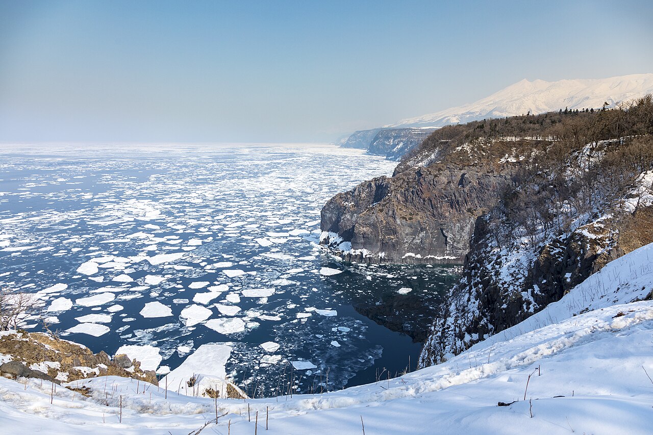
Shiretoko, inscribed by UNESCO in 2005 on the northeastern tip of Hokkaido, is the southernmost place on earth where pack ice forms over open ocean water not covered by permanent ice. The annual drift ice (ryuhyo) that reaches Shiretoko’s coast from the Sea of Okhotsk — arriving in late January and receding in March — triggers a cascade of biological productivity that makes the peninsula one of the most productive marine ecosystems in the North Pacific. The ice carries phytoplankton from Sakhalin to the coast; when it melts, the nutrient pulse feeds a food chain from zooplankton to Steller’s sea eagle (the largest eagle in the world), sperm whale, and Ussuri brown bear. The 71,100-hectare inscription encompasses the full peninsula from its land base to the northern cape (Shiretoko Misaki), accessible only by sea.
Hokkaido and the Okhotsk Sea corridor Kushiro · Abashiri · Sapporo — 90 to 350 km
Ninety kilometres west of Shiretoko by JR Senmo Line from Shari to Kushiro (approximately 2 hours), the Kushiro Wetlands National Park — not a UNESCO World Heritage Site but on Japan’s Tentative List — holds the largest wetland in Japan (18,290 hectares) and the breeding population of the red-crowned crane, one of the rarest cranes in the world. The Kushiro Wetland and the Shiretoko Peninsula together form the eastern Hokkaido ecology circuit: the marine productivity of Shiretoko’s drift-ice season feeds the river systems that flow through the Kushiro Wetland, and the cranes that winter in the wetland fish the same rivers during spring. Hokkaido’s eastern lowland ecology — crane wetland, salmon river, brown bear coast — is accessible in a 3-day driving circuit from the Memanbetsu Airport (Hokkaido’s eastern air hub) that includes Shiretoko as its northern anchor. From Shiretoko’s Utoro visitor centre, Kushiro is reached by JR from Shari Station or by car on Route 244 south.
One hundred fifty kilometres west of Shiretoko by JR from Shari to Abashiri (30 minutes) and Senmo Line south, or by Route 244 along the Okhotsk coast, the Abashiri area is Hokkaido’s primary drift-ice tourism hub. The Garinko II icebreaker ship operates from Monbetsu Port (130 kilometres west of Abashiri) from late January through March, providing passenger access to the drift ice field outside the Shiretoko UNESCO boundary. The Okhotsk Drift Ice Museum (Aurora Drift Ice Museum) in Abashiri presents the science and ecology of the drift ice in a facility with a walk-in cryogenic chamber displaying actual drift ice specimens. Abashiri is also known for its prison museum (Abashiri Prison Museum) — the former Meiji-period penitentiary where political prisoners and common criminals were transported from Honshu to develop Hokkaido’s frontier landscape, a history directly connected to the Meiji Industrial Revolution inscription’s documentation of state-directed labour in Japan’s 19th-century development. From Utoro on the Shiretoko Peninsula, Abashiri is 90 minutes by JR from Shari or approximately 60 minutes by car.
Three hundred fifty kilometres southwest of Shiretoko by JR from Shari to Shin-Chitose Airport or Sapporo (approximately 4 hours by limited express), Sapporo is the gateway city for Hokkaido’s heritage and the connection point for flights to Honshu. Sapporo holds no UNESCO inscription but is the hub for the Jomon Prehistoric Sites in Northern Japan — 12 of whose 17 components are in Hokkaido, concentrated around the Nibutani and Lake Shikotsu areas. The Sapporo Jomon component sites (Kiusu Earthwork Burial Circles in Chitose City, 40 kilometres from Sapporo) document the same hunter-gatherer culture that the Sannai-Maruyama site in Aomori (the inscription’s most visited component) represents in northern Honshu. For visitors combining Shiretoko with the Jomon inscription, Sapporo is the natural base: Kiusu in Chitose and the Kemausi Ruins in Sapporo City itself are within 40 kilometres of Shin-Chitose Airport. From Shiretoko, the journey to Sapporo requires the Shari-to-Abashiri local connection and the Abashiri-to-Sapporo Okhotsk limited express (approximately 3.5 hours).
Four hundred kilometres south by Shinkansen from Shin-Hakodate-Hokuto (reached by limited express from Sapporo, approximately 4 hours), the Tohoku UNESCO corridor begins with the Jomon sites and Shirakami-Sanchi of northern Honshu. The Hokkaido Shinkansen currently extends to Shin-Hakodate-Hokuto; extension to Sapporo is under construction for completion by 2030, which will reduce Honshu-to-Sapporo Shinkansen travel time to approximately 5 hours from Tokyo. For the current period, the most time-efficient route from Shiretoko to Honshu UNESCO sites is via Memanbetsu Airport to Chitose Airport and domestic flight to Osaka or Tokyo, rather than the surface combination of ferry and Shinkansen.
The Shiretoko wildlife circuit Inside the inscription — day routes
Within the inscription, the primary visitor access corridor extends along the western coast of the peninsula from the Utoro visitor centre to the Shiretoko Five Lakes (Goko) — a forest-and-lake landscape at the foot of the Rausu and Iou volcanoes where brown bears are observed year-round. The Furepe Falls (14 metres) on the Utoro coast drop directly from a seacliff to the sea — the fall’s flow is entirely from groundwater (no surface stream feeds it), making it a visual curiosity of Shiretoko’s geology. The eastern coast of the peninsula is less accessible: Rausu Town, at the peninsula’s base on the Pacific side, is the launch point for Steller’s sea eagle watching (winter) and killer whale and sperm whale viewing (summer) on the Nemuro Strait between Hokkaido and the disputed Kuril Islands (occupied by Russia, claimed by Japan). The Kuril Islands are visible from Shiretoko’s eastern coast on clear days — the southernmost island, Kunashir/Kunashiri, is approximately 25 kilometres offshore — making Shiretoko the closest point on Japanese soil to Russian-administered territory and one of the few UNESCO inscriptions from which an active territorial dispute is directly visible.
Practical information
Shiretoko is accessed primarily through Utoro Town on the peninsula’s western coast. From Tokyo, the most efficient route is by flight to Memanbetsu Airport in eastern Hokkaido (2 hours from Haneda or Narita) and bus or rental car to Utoro (approximately 90 minutes). From Sapporo, the Okhotsk limited express reaches Abashiri in approximately 3.5 hours; bus or rental car from Abashiri reaches Utoro in 90 minutes. JR Bus operates a seasonal route from Abashiri to Utoro directly (approximately 90 minutes). The Shiretoko Nature Centre at Utoro is the main visitor hub: it provides trail maps, wildlife sighting reports, and operates the shuttle bus to the Shiretoko Five Lakes (mid-April through November). Brown bears are present throughout the inscription area; bear encounter protocols are mandatory for all trailhead access. Access to the northern cape (Shiretoko Misaki) is only by seasonal sightseeing cruise from Utoro (late April through October, weather-dependent); the cape’s archaeological sites — including ancient Ainu camp locations — are not accessible on foot. The peninsula receives peak visitor pressure in summer (July–August); drift ice viewing in late January through early March is a distinct and less crowded experience with different operational infrastructure (icebreaker cruises from Utoro).
Frequently Asked Questions
Why is drift ice (ryuhyo) significant for Shiretoko’s ecology?
Drift ice is significant for Shiretoko’s ecology because it functions as a vehicle for transporting nutrient-rich sea water and ice algae from the Sea of Okhotsk into the nearshore waters of the peninsula’s coast. The ice forms in the brackish coastal waters of the Amur River estuary (in Siberia) and the northwestern Okhotsk Sea, where nutrients from terrestrial runoff produce blooms of diatoms (ice algae) that grow on and within the ice structure. When the drift ice reaches Shiretoko between January and March and begins to melt in March–April, the released diatoms trigger a phytoplankton bloom in the coastal waters that is the base of a food chain of exceptional productivity: zooplankton feed on the diatoms, capelin (a small fish) feed on the zooplankton, Steller’s sea eagles catch the capelin along the ice edge, and sperm whales follow the capelin concentrations offshore. Brown bears, which emerge from winter dens in March–April, also exploit the capelin that wash onto the shore. The drift ice’s annual arrival and departure is the seasonal rhythm that governs the Shiretoko ecosystem; phenological records show that the average date of drift ice first appearance and last occurrence have both shifted approximately 10–14 days later since 1960, compressing the ice season and reducing the annual nutrient pulse. The UNESCO management framework monitors drift ice phenology as the primary indicator of climate change impacts on the Shiretoko inscription.
Are Shiretoko’s brown bears a different subspecies from those in other parts of Japan?
The brown bears of Hokkaido (and Shiretoko) are Ussuri brown bears (Ursus arctos lasiotus), a large subspecies of brown bear native to the Russian Far East, northeastern China, and Hokkaido — Japan’s northernmost main island. Brown bears in Hokkaido are the only native brown bear population in Japan; Honshu, Shikoku, and Kyushu have only the smaller Japanese black bear (Ursus thibetanus japonicus), which is a completely different species. The Ussuri brown bear is the same subspecies as the bears of Kamchatka and the Russian Far East; the Shiretoko population is at the southern end of this subspecies’ range. The Shiretoko Peninsula has one of the densest brown bear populations in the inscription: surveys estimate approximately 600 bears on the peninsula (approximately 8 bears per 100 square kilometres), the highest density in Japan. Bears are routinely observed along the coast in spring (salmon and capelin runs), on the Shiretoko Five Lakes trails (berry-feeding in summer), and at the Shiretoko Pass in autumn (mountain vegetation). The proximity of bears to the visitor infrastructure at Utoro and the Five Lakes requires active management: the Shiretoko Nature Centre maintains a real-time bear sighting log and controls access to specific trail sections when bears are present at close range.
What is the significance of Shiretoko’s location relative to the disputed Kuril Islands?
Shiretoko Peninsula’s eastern coast faces the Nemuro Strait, at whose southern end the island of Kunashir/Kunashiri (called Kunashiri-to in Japanese) is approximately 25 kilometres offshore. Kunashiri is the southernmost of the four islands occupied by the Soviet Union in August 1945 that Japan claims as the “Northern Territories” (Hoppo Ryodo in Japanese); Russia calls them the “Southern Kuril Islands.” The islands have been under Russian/Soviet administration since 1945; Japan has claimed them continuously under the terms of the 1951 San Francisco Peace Treaty (which Russia did not sign) and subsequent Japanese-Soviet and Japanese-Russian diplomatic negotiations. The dispute has prevented Japan and Russia from signing a formal post-World War II peace treaty. From Shiretoko’s Rausu coast, the silhouette of Kunashiri is visible on clear days. Former Japanese residents of the islands — expelled from their homes in 1945 — are permitted to make visits to their families’ graves on the islands under a 1992 bilateral agreement; these visits leave from Nemuro Port (60 kilometres south of the Shiretoko UNESCO boundary). The coincidence of UNESCO natural heritage recognition and active territorial dispute makes Shiretoko one of the more geopolitically complex sites in the international inscription.
Sources
- S1 — UNESCO World Heritage Centre — Shiretoko (Ref. 1193) — https://web.archive.org/web/20230601000000/https://whc.unesco.org/en/list/1193/
- S2 — UNESCO World Heritage Centre — Statement of Outstanding Universal Value (Ref. 1193) — https://whc.unesco.org/en/list/1193/
Spotted an error? Write to editorial@culturalheritageonline.com and we correct it the same day.