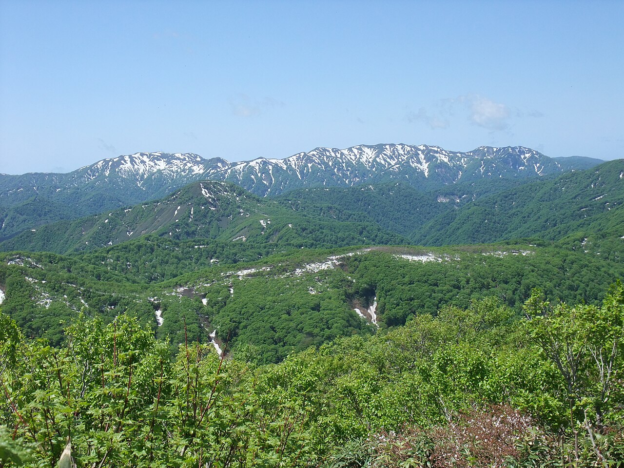
Shirakami-Sanchi, inscribed by UNESCO in 1993 as one of Japan’s first World Heritage Sites, protects 169,700 hectares of virgin temperate beech forest straddling the border of Aomori and Akita Prefectures — the largest surviving stand of primeval Siebold’s beech (Fagus crenata) in East Asia. The forest’s core zone of 16,971 hectares is entirely roadless: no trails, no facilities, and no access without a permit from the Shirakami-Sanchi Nature Conservation Office. The beech forest has been undisturbed by human activity for 8,000 years, since the end of the last glacial period; its structure and species composition represent the climax ecosystem of the Japanese temperate zone before rice agriculture arrived from the continent approximately 2,800 years ago.
The Tohoku corridor and northern Honshu Hiraizumi · Aomori · Akita — 150 to 300 km
One hundred fifty kilometres southeast of Shirakami-Sanchi by JR Gono Line and Tohoku Shinkansen from Aomori to Ichinoseki (approximately 90 minutes), the Temples, Gardens and Archaeological Sites of Hiraizumi in Iwate Prefecture document the 12th-century Buddhist capital of the Oshu Fujiwara at the southern edge of the Tohoku corridor that Shirakami-Sanchi anchors in the north. The beech forest inscription and the Fujiwara capital inscription together define the Tohoku region’s UNESCO span: the oldest ecosystem in northern Honshu and the most ambitious cultural construction in northern Honshu, 150 kilometres apart. The forest that Shirakami-Sanchi protects is the same forest type that would have covered the ridges above Hiraizumi’s Motsuji garden in the 12th century — the deforestation of northern Honshu for agriculture and timber extraction since that period having removed all but this relic stand. From the Shirakami trailheads in western Akita, Hiraizumi is reached by JR Gono Line to Higashi-Noshiro, Ou Line to Akita, and Shinkansen to Ichinoseki (approximately 3 hours).
Two hundred kilometres north by JR from the Shirakami Akita trailheads to Shin-Aomori and local connection, the Jomon Prehistoric Sites in Northern Japan — inscribed in 2021 — document the human civilization that inhabited the forest zone during the 10,000 years before Japan’s rice agriculture period. The 17 component sites of the Jomon inscription spread across Aomori, Akita, Hokkaido, and Iwate Prefectures: the primary site, Sannai-Maruyama in Aomori City, is 30 kilometres northeast of the Shirakami-Sanchi forest’s eastern edge. Sannai-Maruyama documents a community of 500 people living in the forest zone for 1,700 years (3900–2300 BCE), exploiting the beech forest’s food resources (nuts, deer, wild boar) and its construction timber. The chestnut trees found in Sannai-Maruyama’s excavated layers are evidence of arboricultural management — the community appears to have propagated chestnut trees around the settlement edge, creating a managed forest garden at the boundary of the wild beech interior. Shirakami-Sanchi’s roadless core and Sannai-Maruyama’s archaeological settlement represent the two poles of the Tohoku beech zone: untouched interior and humanized edge. From the Shirakami Aomori trailheads, Sannai-Maruyama is 40 kilometres east (30 minutes by road).
Two hundred fifty kilometres southwest by JR Gono Line south and Shinkansen from Akita to Sendai (approximately 90 minutes), the northeast Japan Tohoku cultural circuit continues with the Shiogama-Matsushima bay landscape and the approaches to Hiraizumi. The Shirakami-Sanchi inscription sits at the geographic centre of a Tohoku arc that runs from the Sannai-Maruyama Jomon site (northeast) through the Shirakami forest (north) to Hiraizumi (south) — a 300-kilometre heritage corridor through the historically undervisited northeastern region. For visitors using the Tohoku Shinkansen as a backbone, the full corridor — Jomon sites in Aomori, Shirakami forest in Akita, Hiraizumi in Iwate — is traversable in 4–5 days with careful bus and local train connections.
Three hundred kilometres north by Shinkansen from Shin-Aomori to Shin-Hakodate-Hokuto (approximately 30 minutes) and limited express to Sapporo (approximately 3 hours), Hokkaido’s natural heritage provides the northern extension of the Shirakami-Sanchi beech-forest biogeographic context. The Shiretoko Peninsula in northeastern Hokkaido, inscribed in 2005, is the Japanese site where pack ice from the Sea of Okhotsk reaches its southernmost temperate-zone coast — the productivity of the spring ice-melt nutrient pulse feeds the same food chain (salmon, brown bears, Steller’s sea eagles) that the Shirakami forest supports in terrestrial form. The two natural inscriptions — Shirakami-Sanchi’s beech forest and Shiretoko’s marine-terrestrial interface — together document the ecological endpoints of northern Japan: temperate-zone forest climax and Arctic-margin sea-ice margin, separated by 500 kilometres of Honshu and Hokkaido landscape.
West to the Sea of Japan coast and Sado Island Sado Island · Niigata — 350 km
Three hundred fifty kilometres south and southwest of Shirakami-Sanchi by JR connections through Akita and Niigata, the Sado Island Gold Mine (inscribed 2024) in the Sea of Japan is the nearest UNESCO site along the Japan Sea coast from the Shirakami mountains. The Sado mine produced gold for the Tokugawa mint from the 17th century; the Edo-period administrative and commercial network that managed the mine operated through the same Japan Sea coastal ports that the Shirakami beech region’s timber was historically exported through. The mountain geography of northwestern Honshu — the Ou and Dewa mountain ranges — forms the watershed between the Pacific-draining rivers that flow through the Shirakami and Hiraizumi landscapes and the Japan Sea-draining rivers that served the Akita and Niigata timber ports. From the Shirakami forest’s Akita trailheads, Niigata (the ferry port for Sado) is reached by JR Uetsu Line (approximately 3 hours), then Sado Kisen jet ferry to Sado (approximately 60 minutes).
Practical information
Shirakami-Sanchi’s core zone requires a permit from the Aomori or Akita Nature Conservation Offices; permits are issued in limited numbers daily and access is restricted to designated research and conservation activities. The buffer zone and surrounding trails are accessible without permit. The most practical access points are: Anmon Falls in Aomori Prefecture (accessed from Route 101 via Nishimekka trailhead, 30 minutes from JR Juniko Station on the JR Gono Line); Aoike Pond (Blue Pond) in the Aomori buffer zone, 15 minutes from Juniko Station by taxi; and the Sangen-dake and Mienai-dake trailheads in Akita Prefecture, accessed by bus from Noshiro City. The nearest Shinkansen stations to the Aomori access points are Shin-Aomori (80 minutes by JR Gono Line to Juniko) and Akita (90 minutes to the Akita buffer zone trailheads by bus). The Tsugaru Shirakami intercity highway bus connects Hirosaki (Aomori city served by Shinkansen at Shin-Aomori) to Noshiro (Akita) through the Shirakami buffer zone, running along Route 101 through the forest’s western fringe with scheduled stops at Juniko and other access points — this bus is the most convenient access option for visitors without a car. The full Tsugaru Shirakami crossing on foot (approximately 45 kilometres of mountain trail) requires 3 days with overnight stays in mountain huts; hut reservations are made through the local trail associations and require Japanese language ability or a guide.
Frequently Asked Questions
Why is Shirakami-Sanchi’s core zone roadless and how is it accessed?
Shirakami-Sanchi’s core zone was designated roadless under the 1993 UNESCO inscription’s management plan as a direct response to the 1970s–1980s controversy over a proposed forest road that would have bisected the area for timber extraction. The controversy — in which environmental groups, including the Japanese branch of the IUCN, campaigned against the road and its associated logging plan — directly triggered the UNESCO nomination as a mechanism for achieving the protection that national forest management rules had not secured. The outcome was an inscription whose management requirements included permanent roadlessness and access restriction for the 16,971-hectare core. Without roads, the core zone’s old-growth beech forest has developed undisturbed since the end of the last glaciation approximately 8,000 years ago; the stand structure includes trees of 500 years age and a multi-layered understorey of subordinate beech, oak, and magnolia that represents the full successional sequence of temperate broadleaf forest in northern Japan. Access to the core zone is by permit from the Shirakami-Sanchi Nature Conservation Coordinator (appointed by the Environment Ministry) for research and conservation purposes only; the annual permit quota is limited to prevent trail formation. The surrounding buffer zone of approximately 150,000 hectares is managed under national forest rules and includes legal hiking trails — the 45-kilometre Tsugaru Shirakami ridge trail runs along the core zone’s outer boundary and provides the primary visitor experience of the inscription.
What is the significance of Siebold’s beech as a forest species?
Siebold’s beech (Fagus crenata), the dominant tree of Shirakami-Sanchi’s forest, is the East Asian analogue of European beech (Fagus sylvatica) — the same genus, with similar ecological roles in temperate-zone forest systems. Siebold’s beech is the climax species of the temperate zone on the Japan Sea side of Honshu and Shikoku, meaning that in the absence of disturbance it outcompetes other tree species to dominate the canopy over centuries. In Shirakami-Sanchi’s 8,000-year undisturbed interval, the beech has reached its maximum expression: trees of 30-metre height and 1-metre diameter at breast height, with a closed canopy that transmits less than 1% of incoming light to the forest floor. The characteristic interior of a mature Siebold’s beech forest is cathedral-like: smooth grey bark reflecting the winter light, near-total shade in summer, and a carpet of moss and beech seedlings in the patches of light. The beech nuts are a keystone food source for the Asiatic black bear, Japanese serow (a goat-antelope), Japanese beech dormouse, and several raptor species that nest in the old-growth cavities. Shirakami-Sanchi’s beech forest is the subject of ongoing phenological monitoring for the effects of climate change: beech leafout dates have advanced approximately 10 days since 1960, and the tree-line elevation is rising in response to warming winters — trends that the long-term UNESCO management framework is tracking across the inscription’s area.
How does Shirakami-Sanchi compare to other old-growth beech forests in the UNESCO inventory?
Shirakami-Sanchi is one component of the global pattern of old-growth beech forest recognized by UNESCO as a serial inscription: the “Primeval Beech Forests of the Carpathians and Other Regions of Europe” inscription (originally Slovakia and Ukraine in 2007, expanded to 18 European countries by 2021 with 94 component sites) documents the European beech (Fagus sylvatica) in the same way that Shirakami-Sanchi documents Siebold’s beech in Japan. The ecological principles are identical: beech climax forest as a reference ecosystem for the undisturbed temperate broadleaf zone. The differences are taxonomic (different beech species) and geographic (different continents separated by the Bering Land Bridge during the Pleistocene, when the shared ancestor of Fagus crenata and Fagus sylvatica differentiated). Shirakami-Sanchi is the only old-growth beech forest outside Europe with UNESCO recognition; UNESCO periodic reports have noted the scientific value of cross-inscription comparison between the Japanese and European beech sites as analogues for understanding temperate broadleaf forest dynamics under comparable climate change pressures. The European inscription’s expansion to 18 countries reflects the political will to use UNESCO recognition to protect relic beech stands that would otherwise face commercial pressure — the same mechanism that drove Shirakami-Sanchi’s nomination in 1993.
Sources
- S1 — UNESCO World Heritage Centre — Shirakami-Sanchi (Ref. 663) — https://web.archive.org/web/20230601000000/https://whc.unesco.org/en/list/663/
- S2 — UNESCO World Heritage Centre — Statement of Outstanding Universal Value (Ref. 663) — https://whc.unesco.org/en/list/663/
Spotted an error? Write to editorial@culturalheritageonline.com and we correct it the same day.