
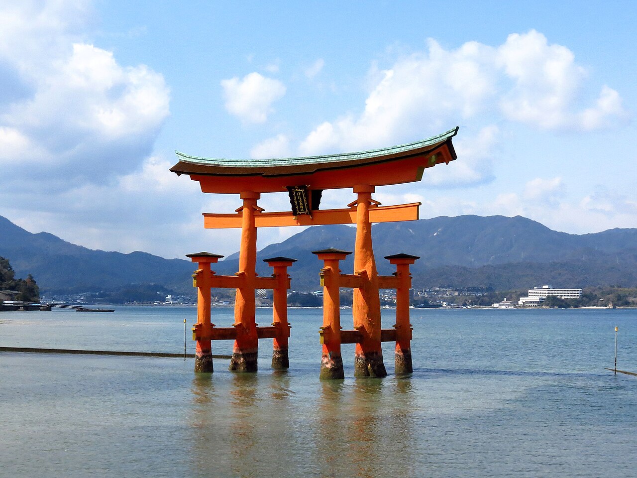
Itsukushima Shrine, inscribed by UNESCO in 1996, stands over the tidal channel of the Seto Inland Sea on Miyajima Island in Hiroshima Prefecture. The shrine has been built on stilts above the water since the 6th century to preserve the island’s sacred ground; the 16-metre O-torii gate rising 200 metres offshore has been rebuilt eight times over 800 years and most recently in 1875. Taira no Kiyomori expanded the shrine to its current plan in 1168 CE as a declaration of the Taira clan’s military and spiritual authority over western Japan.
The Hiroshima coast and the western Seto Inland Sea Hiroshima · Shimane · Nagasaki — 20 to 350 km
Twenty minutes from Miyajima by JR and ferry, the Hiroshima Peace Memorial in Hiroshima City preserves the ruin of the 1915 Industrial Promotion Hall — the only structure within 600 metres of the atomic bomb’s detonation point on 6 August 1945 that remained upright. The bomb detonated at 580 metres altitude nearly directly overhead, directing the main blast force downward through the roof rather than laterally into the walls; the exterior shell and central dome remained standing while the interior was completely destroyed. Hiroshima City Council voted in 1966 to preserve the structure permanently and unreconstructed; UNESCO inscribed it alongside Itsukushima in 1996 in the same candidacy cycle. The two sites together — the water-built shrine of a feudal maritime clan and the preserved atomic ruin of a 20th-century city — are the most frequently paired UNESCO heritage experiences in western Japan, connected by a single JR-and-ferry pass available from Hiroshima Station. Most visitors take the Itsukushima ferry from Miyajimaguchi in the morning at low tide (to walk to the gate base), return to Hiroshima by noon, and spend the afternoon at the Peace Memorial Museum and Park.
Two hundred forty kilometres east by Sanyo Shinkansen from Hiroshima to Himeji (approximately 55 minutes), Himeji Castle is the largest and best-preserved feudal castle in Japan. The 83-building complex on its 45-metre hill was completed in 1609 and shares with Itsukushima Shrine the distinction of surviving the 20th century intact: the castle was not hit during the American firebombing raids of July 1945 that destroyed much of Himeji City, and the shrine on Miyajima Island was never a military target. Himeji Castle and Itsukushima Shrine were both inscribed by UNESCO in 1993 and 1996 respectively — the first and second wave of Japan’s UNESCO submissions — and together with the 1996 Hiroshima inscription they form the heritage cluster of western Honshu. The castle’s white-plastered exterior was designed for fire resistance; the shrine’s position over water was designed for religious purity; both strategies, originating centuries apart, proved effective at excluding the destruction of the 20th century.
Two hundred sixty kilometres northwest of Miyajima by JR and limited express from Hiroshima to Oda City (approximately 2 hours), the Iwami Ginzan Silver Mine and its Cultural Landscape in Shimane Prefecture was the world’s largest silver producer in the 1580s. The mine supplied one-third of global silver output during peak extraction and was traded through the Seto Inland Sea ports to Portuguese and Dutch merchants. Itsukushima Shrine received direct patronage from the Taira clan precisely because the shrine controlled the sea routes through the Inland Sea along which the silver and other trade goods moved; the Taira maritime power and the Iwami silver trade occupied the same geographic and commercial corridor. The preserved mine site includes 700 shafts in the mountain, processing foundations in the valley below, and the intact port-route town of Tomogaura at the estuary. From Miyajima, the mine is reached by ferry to Hiroshima, JR to Hiroshima Station, and limited express to Oda City (80 minutes), with a bus to Omori Ginzan (15 minutes).
Three hundred fifty kilometres southwest by JR and Shinkansen from Hiroshima to Hakata and limited express to Nagasaki (approximately 3.5 hours total), the Hidden Christian Sites in the Nagasaki Region document a religious community that maintained secret Christianity through 250 years of legal prohibition. The 12 inscribed properties span the Nagasaki Peninsula, the Goto Islands, and the Hirado Peninsula, covering 10 churches or ruins and 2 related sites. The Ooura Cathedral in Nagasaki City, completed in 1865 as the first Western-rite Gothic church in Japan, is the only Western-style building in Japan designated a National Treasure; the discovery of the Urakami community’s secret Christianity at this church in 1865 is documented as the “discovery of hidden Christians” in Vatican archives. The geographic connection between Nagasaki’s Christian history and the Itsukushima-Hiroshima corridor runs through the same maritime geography: Nagasaki served as Japan’s only Western-trade port during the isolation period (1639–1853), and the Dutch and Portuguese merchants who traded at Nagasaki also traded at the Hiroshima and Seto Inland Sea ports, linking the two regional histories through the same early-modern commercial network.
East to Kansai and the ancient capitals Kyoto · Nara · Kii Mountains — 340 to 450 km
Three hundred forty kilometres east from Miyajima by Shinkansen from Hiroshima to Kyoto (approximately 90 minutes by Nozomi), the Historic Monuments of Ancient Kyoto provide the densest UNESCO heritage concentration accessible from the Hiroshima region in a single day trip. The Taira clan’s patronage of Itsukushima Shrine in 1168 CE occurred during the same generation that produced the great temple and palace constructions of the late Heian period in Kyoto; Taira no Kiyomori was the dominant political figure of the Kyoto court from approximately 1160 to his death in 1181, and the ornamentation of the Itsukushima Shrine complex was a direct parallel investment to the court’s temple-building in and around the capital. The Byodoin Phoenix Hall in Uji — part of the Kyoto UNESCO inscription — was completed in 1053 CE, a century before Kiyomori’s renovation of Itsukushima; both buildings apply the same Heian aesthetic of water reflection, gilded detail, and bilateral symmetry to create spaces for contemplating Amida’s paradise. From Miyajima, a round-trip Nozomi day trip to Kyoto from Hiroshima (90 minutes each way) allows 5–6 hours in Kyoto, sufficient for the Higashiyama or western temple cluster.
Three hundred ninety kilometres east by Shinkansen to Kyoto and JR Nara Line onward, the Historic Monuments of Ancient Nara document the pre-Kyoto phase of Japanese state Buddhism. Todai-ji’s Great Buddha Hall — the world’s largest wooden building at two-thirds its post-fire 1709 reconstruction scale — houses a 15-metre bronze Buddha whose scale of ambition equals anything attempted in the Seto Inland Sea region. The 1,200 sika deer of Nara Park, under imperial protection since the 8th century, create a heritage landscape with no parallel in the Hiroshima region. Nara is reachable from Miyajima in approximately 2.5 hours (Shinkansen to Kyoto, Kintetsu to Nara) and is most practically visited as an extension of the Kyoto itinerary rather than a separate day trip from Hiroshima.
Four hundred fifty kilometres east by Shinkansen to Osaka and limited express southward, the Sacred Sites and Pilgrimage Routes in the Kii Mountain Range — Japan’s largest cultural UNESCO inscription — document the mountain asceticism tradition that the Seto Inland Sea maritime tradition of the Hiroshima region never produced. The three Grand Shrines of Kumano, connected by 237 kilometres of pilgrimage trail, received the Kyoto court’s pilgrimages from the 10th century. The contrast between the Itsukushima Shrine’s water-built devotion — accessible by boat to court nobles and wealthy merchants — and the Kumano Kodo’s physical demands — weeks of mountain walking through rain and mud — represents two entirely different models of sacred encounter within the same Heian cultural period. Mount Koya’s Okunoin cemetery, with 200,000 stone markers around the founder Kukai’s mausoleum, and Nachi Falls (133 metres, the highest unbroken waterfall in Japan), worshipped as a deity directly, extend the Kii inscription’s range of sacred forms. From Miyajima/Hiroshima, the Kii Mountains are reached via Shinkansen to Shin-Osaka and Nankai Koya Line to Gokurakubashi.
Practical information
Miyajima Island is reached from Hiroshima Station by JR Sanyo Line to Miyajimaguchi (25 minutes) and JR ferry to Miyajima (10 minutes); the ferry runs continuously and is covered by JR Pass. The island has no cars; walking or bicycle are the primary means of moving between the shrine, the ferry terminal, and the forested interior. The Itsukushima Shrine itself opens at 6:30 and closes at 18:00 in standard periods, with extended evening hours in summer. Entry to the shrine’s main structure is paid; the O-torii gate and its surrounding tidal flat are accessible without entry fee at all hours. The timing of the visit in relation to tide matters: low tide exposes the sand flat around the gate base and allows walking to within metres of the structure; high tide covers the sand and produces the famous “floating” appearance. Tide tables are available from Hiroshima Station tourist counters and from the Miyajima tourist authority website. The island also holds the Daisho-in Buddhist temple complex (free, on the forested hillside above the shrine), 500 tame deer, and several ryokan and restaurants. The ferry from the island last departs Miyajima at 23:15; an overnight stay on the island to see the gate at low-tide dawn is possible with ryokan reservation.
Frequently Asked Questions
Why is Itsukushima Shrine built over the water rather than on the island’s ground?
Itsukushima Shrine was built over the sea because Miyajima Island itself was (and to some degree remains) considered sacred ground that must not be contaminated by human construction, agricultural use, or death. The taboo has been documented in Japanese sources since at least the Heian period (794–1185 CE): no burials were permitted on the island, and until the Meiji period, women were forbidden from giving birth there. The existing prohibitions — still observed in modified form — include a ban on dogs and cats, a restriction on farming and logging in the island’s interior, and the maintenance of the cemetery-free designation. Building the shrine over the tidal channel rather than on the land allowed the community to worship at a sacred site on the sacred island without treating the island as ordinary buildable ground. The O-torii gate, standing in the water 200 metres from the shrine complex, extends this logic: the gate marks the boundary between the sacred sea and the ordinary sea, and passing through it by boat (the original approach) was the ritual transition into sacred space. The shrine’s position also has a practical consequence that has been celebrated in Japanese art and literature for 800 years: at high water, the entire complex appears to float on the tidal channel, creating a reflection that has been painted, woodblock-printed, and photographed more than almost any other Japanese scene.
What is the best time to visit Itsukushima to see the O-torii gate at high and low water?
The O-torii gate’s famous high-water “floating” appearance and the low-water sand-walk experience require two different tidal states, each offering a distinct encounter with the same structure. High water is most dramatic approximately 1 hour before high tide, when the water surface is calm and the reflection is cleanest; direct afternoon or evening light rakes across the gate columns and produces the warm tones most represented in photography and woodblock prints. Low tide — any tide below approximately 0.5 metres — exposes the sand flat surrounding the gate base and allows visitors to walk from the shore to within metres of the wooden columns; the gate at close range is considerably larger than it appears from the shrine veranda. Tide tables for Miyajima are published monthly by the Japan Meteorological Agency and are available from Hiroshima Station tourist counters. A standard one-day visit typically catches one tidal state; overnight visitors can plan to catch both. The gate’s traditional approach was by boat from the sea; the contemporary ferry approaches from the north, and the O-torii is best photographed from the shrine veranda (looking out to sea) or from the beach east of the ferry terminal where the full reflection is visible at high water. Autumn foliage (October–November) and spring cherry blossoms (late March to early April) add foreground colour to the gate views but coincide with the island’s highest visitor pressure.
How are Itsukushima Shrine and the Hiroshima Peace Memorial managed together as a UNESCO dual inscription?
Itsukushima Shrine and the Hiroshima Peace Memorial are two separate UNESCO World Heritage Sites that were inscribed in the same year (1996) but are managed independently. The shrine is administered by the Itsukushima Shrine religious corporation as an active Shinto place of worship; the Peace Memorial is administered by Hiroshima City as a memorial and museum complex. The two sites share no common management structure beyond the coordination required for UNESCO periodic reporting. UNESCO inscribed them separately under different criteria: Itsukushima Shrine under criteria i, ii, iv, and vi (architecture, cultural exchange, typology, and artistic significance); the Peace Memorial under criterion vi alone (direct association with universal significance). The dual inscription within the same UNESCO submission cycle created the practical tourism consequence that is now universal in western Japan itinerary planning — the “Hiroshima day” that covers both sites by ferry — but this pairing is a tourism construction rather than a heritage management framework. The two sites have in common only their geographic proximity and their survival of the 20th century in forms that directly confront what happened in 1945: the shrine’s presence untouched on its sacred island 20 minutes from the hypocenter, and the dome’s preserved ruin at the hypocenter itself.
Sources
- S1 — UNESCO World Heritage Centre — Itsukushima Shinto Shrine (Ref. 776) — https://web.archive.org/web/20230601000000/https://whc.unesco.org/en/list/776/
- S2 — UNESCO World Heritage Centre — Statement of Outstanding Universal Value (Ref. 776) — https://whc.unesco.org/en/list/776/
Spotted an error? Write to editorial@culturalheritageonline.com and we correct it the same day.



.jpg)