
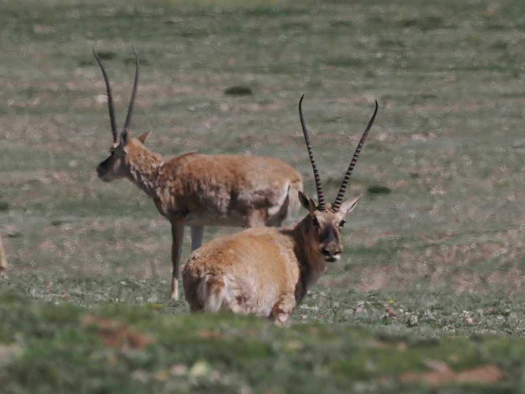
Qinghai Hoh Xil, inscribed as UNESCO World Heritage in 2017, covers 45,000 square kilometres of the Qiangtang Plateau in northwestern Qinghai Province at elevations between 4,500 and 6,860 metres above sea level, making it the largest terrestrial UNESCO inscription in China and the third largest globally. The property protects the calving grounds and migratory corridor of approximately 50,000 Tibetan chiru (Pantholops hodgsonii), which travel up to 400 kilometres annually from winter grazing ranges to summer calving floodplains on the Zonag Lake plain. Between 1990 and 1999, an estimated 18,000 chiru were killed for shahtoosh wool used in luxury shawls, prompting the establishment of the Hoh Xil Nature Reserve in 1995 and its conversion to a national nature reserve in 2000; the population had declined to below 20,000 before enforcement of anti-poaching measures reversed the trend.
Southern connections: Potala Palace and the Three Parallel Rivers of Yunnan Lhasa 1,200 km south via road or 2h flight from Golmud; Three Parallel Rivers 1,500 km south — same Tibetan Plateau biogeographic zone
The Historic Ensemble of the Potala Palace in Lhasa, Tibet, inscribed as UNESCO World Heritage in 1994 and extended in 2000 and 2001 to include the Norbulingka Summer Palace and the Jokhang Temple Monastery, is approximately 1,200 kilometres south of the Hoh Xil property by road via National Highway G109 (the Qinghai–Tibet Highway), a route requiring approximately 20 hours of driving from Golmud, or approximately 2 hours by flight from Golmud Devoi Airport to Lhasa Gonggar Airport. The Potala Palace stands on Marpo Ri hill in central Lhasa at 3,650 metres elevation, roughly 850 metres below the lower boundary of the Hoh Xil property. The White Palace (Potrang Karpo) was constructed under the Fifth Dalai Lama beginning in 1645 CE on the foundations of a 7th-century structure attributed to Songtsen Gampo; the Red Palace (Potrang Marpo), housing the funerary chortens of eight Dalai Lamas and the main assembly halls, was added between 1690 and 1694. The inscribed property as extended covers 360,000 square metres of palace, monastery and garden complex. The geographic and historical relationship between Hoh Xil and Lhasa is direct: the Qinghai–Tibet Highway, built 1950–1954, passes through or near the Hoh Xil buffer zone, and the chiru population that the inscription protects occupies the same high plateau that Tibetan civilisation, including the theocratic state centred on the Potala, administered for centuries. The Norbulingka Summer Palace, added to the inscription in 2001, was constructed beginning in 1755 under the Seventh Dalai Lama and covers 36 hectares containing 374 rooms across multiple palace buildings set in a formal garden; it served as the seat of the Tibetan government during summer months. Visiting Lhasa requires a Tibet Travel Permit (obtainable through licensed travel agencies only) in addition to a standard Chinese visa; independent travel within Tibet Autonomous Region is not permitted for foreign nationals, and access regulations have varied significantly over time, requiring confirmation with current official sources before planning.
The Three Parallel Rivers of Yunnan Protected Areas, inscribed as UNESCO World Heritage in 2003, cover approximately 1,700,000 hectares in northwestern Yunnan Province, approximately 1,500 kilometres south-southwest of the Hoh Xil property. The inscription covers the parallel gorges of the Yangtze (Jinsha), Mekong (Lancang) and Salween (Nu) rivers in a section where the three rivers run within 170 kilometres of each other in a north-south corridor, separated by mountain ridges exceeding 6,000 metres. The biogeographic relationship between the Three Parallel Rivers zone and the Hoh Xil plateau is significant: the three rivers originate on the same Tibetan Plateau that Hoh Xil occupies, with the Yangtze headwaters (Tongtian River) rising within the Hoh Xil buffer zone and flowing south before turning east toward the Three Gorges. The Three Parallel Rivers inscription documents one of the world’s highest concentrations of plant diversity, with over 6,000 plant species and 25% of China’s animal species in the gorge system. The vertical range of the inscribed area, from 760 metres at the lowest gorge floors to 6,740 metres at the summit of Kawagebo (Meili Snow Mountain), creates stacked climate zones from subtropical to permanent snow in a horizontal distance of less than 100 kilometres. Access to the Three Parallel Rivers zone is from Lijiang (serviced by Lijiang Sanyi Airport from Kunming and major Chinese cities) or from Shangri-La (Diqing Shangri-La Airport), both in northwestern Yunnan; road access into individual gorge sections requires 3 to 8 hours by bus from either city depending on the destination gorge.
Northern corridor: the Mogao Caves at Dunhuang and the Silk Roads Chang’an–Tianshan Corridor Dunhuang 800 km north via G315, approximately 8h by road from Golmud; Silk Roads corridor traverses the Qinghai plateau as an alternative southern route
The Mogao Caves at Dunhuang, inscribed as UNESCO World Heritage in 1987, are approximately 800 kilometres north-northwest of the Hoh Xil property, reachable in approximately 8 hours by road from Golmud via National Highway G315 across the Qaidam Basin in the northern Qinghai depression. Dunhuang lies at 1,138 metres elevation in the Gansu Corridor, in sharp ecological contrast to the 4,500-metre Hoh Xil plateau: the Mogao site occupies a cliff face in the desert southeast of Dunhuang oasis, where the Dachuan River carved a sandstone escarpment that Buddhist monks began excavating in 366 CE according to the earliest textual source (the Tang-dynasty monk Daoxuan’s account). The inscription covers 492 surviving decorated cave chapels in a continuous honeycomb cliff face approximately 1,600 metres long, containing approximately 45,000 square metres of mural paintings and more than 2,000 painted clay sculptures spanning from the Northern Liang dynasty (4th century CE) through the Yuan dynasty (14th century). The Cave 17 Library Cave (Dunhuang manuscript cave), sealed around 1002 CE and reopened in 1900, contained approximately 40,000 manuscripts and painted silk banners; the collection was dispersed to museums in London, Paris, St. Petersburg and Beijing through the acquisitions of Aurel Stein (1907), Paul Pelliot (1908) and others between 1907 and 1914. The ecological corridor connecting Dunhuang to the Hoh Xil property is the Qaidam Basin, a high-altitude (2,600–3,000 m) inland basin north of the Kunlun Mountains that separates the Qinghai Plateau from the Gansu Corridor. The Silk Road routes that supplied Dunhuang as a trading and religious way-station crossed this basin, and a southern variant of the Silk Road ran directly across the Qinghai Plateau through Golmud and the eastern edge of the current Hoh Xil property, connecting the interior of China to Central Asia via a high-altitude route that avoided the more contested northern passes.
The Silk Roads: the Routes Network of Chang’an–Tianshan Corridor, inscribed jointly by China, Kazakhstan and Kyrgyzstan as UNESCO World Heritage in 2014, covers 33 sites along approximately 5,000 kilometres of Silk Road routes between Chang’an (Xi’an) in Shaanxi and the Zhetysu region of Kazakhstan. The inscription does not directly include the Qinghai route, but the geographic and historical relationship between the Hoh Xil plateau and the Silk Road network is substantive: the Qinghai route (Hexi-Qinghai Route) was an established alternative to the Gansu Corridor route documented in Tang-dynasty sources, used particularly during periods when the Gansu Corridor was controlled by hostile powers (notably during the Tibetan Empire’s control of the Hexi Corridor in the 8th and 9th centuries, which forced Tang-dynasty traffic to use the Qinghai–Tibetan Plateau route). The Chang’an–Tianshan Corridor inscription includes sites at Luoyang, Zhengzhou, Xi’an and along the Gansu Corridor to the Xinjiang border; the closest inscribed site to the Hoh Xil property is approximately 800 kilometres north at the eastern end of the corridor near Zhangye. Visiting the inscribed Chang’an–Tianshan sites in combination with Dunhuang and the Qinghai Plateau is practical via the Lanzhou–Xinjiang high-speed rail line, which connects Xi’an to Dunhuang via Lanzhou and Zhangye, then south to Golmud by conventional rail (Dunhuang to Golmud approximately 6 hours by train).
Practical information
Hoh Xil is not accessible for general tourism: the property has no visitor infrastructure, and access to the core zone is restricted to scientific research expeditions with permits from the Qinghai Provincial Government. The closest accessible settlement is Golmud, a city of approximately 300,000 people in the Qaidam Basin 500 kilometres east of the property boundary, reachable by air from Xining (daily flights, approximately 1 hour) or by rail from Xining via the Qinghai–Tibet Railway (approximately 5 hours on the highest conventional railway in the world, crossing the Kunlun Pass at 4,767 metres). The Qinghai–Tibet Railway runs through the Hoh Xil buffer zone between Golmud and Lhasa, and the train journey provides the only legal and practical way for most visitors to traverse the plateau: the railway crosses the Hoh Xil plain and passes within 20 kilometres of the chiru calving grounds on the Zonag Lake plain, and wildlife including chiru can be observed from train windows during the June–July calving season. The train journey from Golmud to Lhasa takes approximately 12 hours on the Qinghai–Tibet line; passengers should allow 1–2 days in Golmud at 2,780 metres altitude before boarding to begin acclimatisation before the train ascends above 5,000 metres. All trains on the line supply supplemental oxygen in carriages; altitude sickness prophylactics (acetazolamide) should be discussed with a physician before travel. The best season for chiru observation from the train is late June, when the females are migrating north to calve and often cross near the railway embankment; adults and newborn calves appear along the rail corridor in July before the southward return migration begins in August.
Frequently Asked Questions
Why is the Tibetan chiru’s shahtoosh trade illegal, and what is shahtoosh wool?
Shahtoosh (from Persian and Urdu meaning “king of wool”) is a fibre obtained from the underbelly hair of the Tibetan chiru (Pantholops hodgsonii). The individual fibres measure 9–12 microns in diameter, finer than cashmere (14–19 microns) and among the finest natural fibres produced by any mammal; a single shahtoosh shawl of approximately 100 grams requires the fibres from 3 to 5 chiru. Unlike sheep wool or cashmere goat fibre, shahtoosh cannot be obtained by shearing a live animal: the chiru’s underbelly fibre is shed in small quantities and cannot be collected sustainably from wild animals; in practice, the commercial shahtoosh trade has always depended on killing the animal and removing the fibres from the skin. The chiru is listed on CITES Appendix I (trade prohibited) and under China’s Wildlife Protection Law as a Class I protected species. Despite this, a commercial shahtoosh shawl trade operated through Kashmir and Ladakh (where Tibetan chiru fibres were historically traded legally before the CITES listing) into the 1990s and beyond, with shawls retailing for $5,000 to $17,000 in Western markets. Indian, British and US customs seizures in the 1990s and early 2000s, combined with high-profile prosecutions of dealers and buyers in New York, London and Delhi, documented the scale of the trade and contributed to demand reduction. China’s establishment of the Hoh Xil Nature Reserve in 1995, partly staffed by volunteer anti-poaching patrols (the Sonam Dargye Patrol, named for a warden killed by poachers in 1994), was a direct response to the documented collapse of the chiru population. Population surveys between 1990 and 2006 estimated a decline from approximately 1 million to fewer than 75,000 animals; subsequent anti-poaching enforcement and habitat protection have allowed the population to partially recover to current estimates of approximately 300,000 animals across the Qinghai–Tibet Plateau.
What does “the largest UNESCO natural inscription in China” mean in practical terms, and how does Hoh Xil compare in size to other large natural inscriptions globally?
The Hoh Xil inscription covers 45,000 square kilometres of core zone within a broader 83,000-square-kilometre property boundary including buffer zones. For comparison, the entire country of Switzerland is 41,285 square kilometres; Hoh Xil’s core zone is larger than Denmark (43,094 sq km) and approximately twice the area of Wales (20,779 sq km). Within China, Hoh Xil substantially exceeds the next largest natural UNESCO inscription: the Three Parallel Rivers of Yunnan Protected Areas cover approximately 17,000 square kilometres of core zone, and the Sichuan Giant Panda Sanctuaries cover 924,500 hectares (9,245 sq km). Globally, the largest natural World Heritage inscriptions by area are the Phoenix Islands Protected Area in Kiribati (408,250 sq km, inscribed 2010), the Papahānaumokuākea Marine National Monument in Hawaii (362,075 sq km, inscribed 2010) and the Heard and McDonald Islands in the Australian Antarctic (37,200 sq km, inscribed 1997); Hoh Xil ranks among the five largest terrestrial (non-marine) natural inscriptions globally. The practical significance of this scale is that the property encompasses complete ecological processes that cannot be protected at smaller scales: the entire annual migration circuit of the Tibetan chiru, from winter grazing grounds in the eastern Qiangtang Plateau to summer calving grounds on the Zonag Lake plain, falls within the inscribed property boundary. A smaller inscription would have protected the calving grounds or the winter range but not the migration corridor connecting them, making anti-poaching enforcement along the migration route impossible under the UNESCO framework.
What is the Qinghai–Tibet Railway, and why was building it an engineering challenge?
The Qinghai–Tibet Railway (Qingzang Tieluo) connects Golmud in Qinghai Province to Lhasa in Tibet Autonomous Region across 1,142 kilometres of the Qinghai–Tibet Plateau, with 960 kilometres above 4,000 metres elevation and the summit at the Tanggula Pass station at 5,068 metres (the highest railway station in the world). The section between Golmud and Lhasa, opened in 2006, crosses approximately 550 kilometres of permafrost, where the ground beneath the surface remains permanently frozen year-round and is sensitive to temperature change. The principal engineering challenge was preventing the railway embankment from destabilising the permafrost beneath it: a conventional earthen embankment would insulate the frozen ground, causing the permafrost to thaw under the embankment and the trackbed to subside unevenly. Chinese Railway engineers addressed this through three main techniques. First, the use of elevated viaducts for approximately 160 kilometres of the most sensitive permafrost sections, lifting the track off the ground surface entirely and allowing air circulation beneath. Second, the installation of thermosyphon cooling pipes alongside the embankment in lower sections: these passive devices extract heat from the embankment through a refrigerant fluid that evaporates at ground level (absorbing heat from the soil) and condenses at the radiator fins above ground (releasing the heat to the air), keeping the permafrost below the embankment frozen year-round without external power. Third, embankment design using crushed rock layers with large void spaces that allow cold air to percolate through the embankment in winter, cooling the foundation zone. The railway also crosses approximately 30 kilometres of land within the Hoh Xil property; at these sections, 33 wildlife underpasses were built beneath the embankment to allow chiru and other animals to continue their migration without crossing the tracks.
Sources
- S1 — UNESCO World Heritage Centre — Qinghai Hoh Xil (Ref. 1540) — https://web.archive.org/web/20230601000000/https://whc.unesco.org/en/list/1540/
- S2 — Sanjiangyuan National Park Administration — https://whc.unesco.org/en/list/1540/
- S3 — Seidensticker, John. <em>Riding the Tiger: Tiger Conservation in Human-Dominated Landscapes</em>. Cambridge University Press, 1999. ISBN: 978-0-521-64835-6.
Spotted an error? Write to editorial@culturalheritageonline.com and we correct it the same day.


_02.jpg)