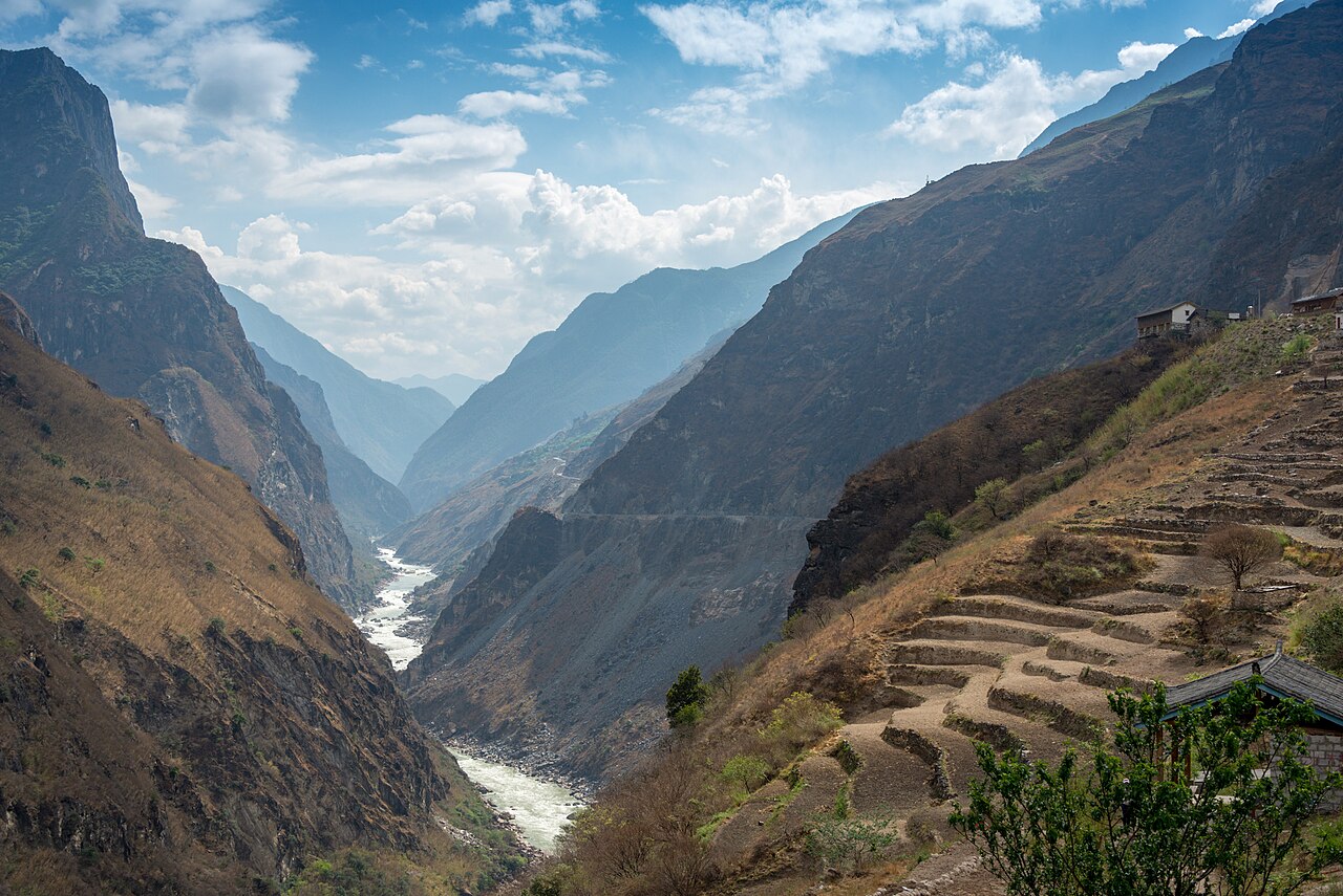
The Three Parallel Rivers of Yunnan Protected Areas were inscribed as UNESCO World Heritage in 2003, covering 1.7 million hectares in northwest Yunnan Province where the Yangtze (Jinsha), Mekong (Lancang) and Salween (Nu) rivers run parallel for approximately 170 kilometres through gorges reaching 3,000 metres in depth. The protected area contains approximately 25 percent of all animal species recorded in China and approximately 20 percent of the country’s higher plant species within its boundaries. The geological collision zone between the Indian tectonic plate and the Eurasian plate that created the gorges is still active, lifting the land surface at approximately 5 millimetres per year according to GPS measurements published by Chinese and international research teams since the 1990s.
South and southeast: Old Town of Lijiang and South China Karst at Shilin Old Town of Lijiang 300 km south, 4h by road; South China Karst Shilin 500 km southeast via Kunming, 2h from Kunming by road
The Old Town of Lijiang in Yunnan Province, inscribed as UNESCO World Heritage in 1997, is approximately 300 kilometres south of the Three Parallel Rivers’ administrative centre at Shangri-La (Zhongdian) and reachable in approximately 4 hours by road along the Yunnan–Tibet Highway (G214) through the Hengduan Mountain valleys. Lijiang has a domestic airport (Lijiang Sanyi Airport) with frequent flights from Kunming (50 minutes) and Chengdu (1.5 hours), making it the primary access point for the Three Parallel Rivers region for visitors arriving by air. The Lijiang UNESCO inscription covers the Old Town (Dayan) and two outlying ancient towns (Shuhe and Baisha), protecting the surviving built environment of the Naxi people, a Tibeto-Burman ethnic minority of approximately 360,000 people whose traditional territory is the Lijiang valley at an elevation of approximately 2,400 metres. The Dayan old town’s plan is organised around a system of three interconnected canals fed by the Black Dragon Pool north of the town, distributing fresh water through the lanes for domestic use; the street plan follows the contours of the surrounding mountain slopes rather than a rectilinear grid, producing an irregular network of stone-paved lanes that differs markedly from the axial-symmetry plans of lowland Chinese towns. The primary architectural form is a modified version of the Chinese three-sided courtyard house (sanheyuan), adapted for the local stone construction tradition and incorporating Naxi decorative elements in the painted timber brackets and column capitals. Lijiang experienced a catastrophic earthquake on 3 February 1996, measuring 7.0 on the Richter scale, which killed 309 people and damaged more than 100,000 buildings in the surrounding counties; the Dayan old town suffered less damage than surrounding modern buildings due to the flexibility of its timber-frame construction, an observation that contributed to the 1997 UNESCO nomination documentation. The spatial connection between Lijiang and the Three Parallel Rivers is structural: the Three Parallel Rivers protected area wraps around the Lijiang valley on its western and northern sides, and the Jinsha River (upper Yangtze) whose gorge forms the western boundary of the inscribed area flows northward past Lijiang before turning east through the Tiger Leaping Gorge (Hutiao Xia), one of the deepest river gorges in the world at approximately 3,900 metres from river surface to adjacent mountain summit (Jade Dragon Snow Mountain, 5,596 metres), located approximately 60 kilometres north of Lijiang town and within the Three Parallel Rivers inscribed area.
The South China Karst, inscribed as UNESCO World Heritage in 2007 (extended 2014), covers four karst sub-types across Yunnan, Guizhou and Chongqing; the Shilin (Stone Forest) component near Kunming in Yunnan Province is the most accessible from the Three Parallel Rivers area, approximately 500 kilometres southeast of Shangri-La via Kunming and approximately 2 hours by road from Kunming. The Shilin Stone Forest covers 350 square kilometres and contains pinnacle karst formations (shilin, stone forest in Chinese) developed over approximately 270 million years through dissolution of Permian limestone by mildly acidic groundwater along vertical fracture systems; the resulting landscape of sharp-edged limestone blades, towers and pinnacles standing 5 to 40 metres above the surrounding plain is the type example of pinnacle karst in global geological literature. The Shilin area is the traditional territory of the Sani subgroup of the Yi ethnic minority; the Sani cultural landscape, including the Torch Festival (celebrated on the 24th day of the sixth lunar month) and the traditional embroidery patterns that appear in Sani dress and handicrafts, is integrated into the visitor experience at the Stone Forest. The connection between Shilin’s Permian limestone karst and the Three Parallel Rivers protected area is geological: the Hengduan Mountain ranges of northwest Yunnan through which the three rivers flow are the uplifted remnant of the same Tethys Sea carbonate platform that produced the karst formations of south Yunnan, deformed and elevated by the Indian Plate collision from approximately 50 million years ago onward. The Chengjiang Fossil Site (see below), approximately 90 kilometres from Kunming, can be combined with a Shilin day-trip in a single Kunming-based excursion, covering Cambrian marine fossils (520 million years old) and Permian terrestrial limestone landscapes (270 million years old) within the same geological succession of Yunnan’s deep time.
Northwest and far northeast: Potala Palace in Lhasa and Chengjiang Fossil Site Potala Palace/Lhasa 1,000 km northwest, 2h flight or 2 days overland via Yunnan-Tibet Highway; Chengjiang Fossil Site 500 km southeast via Kunming, 1h from Kunming to Chengjiang
The Potala Palace in Lhasa, Tibet Autonomous Region, inscribed as UNESCO World Heritage in 1994 (with the Jokhang Temple Monastery added in 2000 and the Norbulingka Palace in 2001 as extensions under the collective inscription “Historic Ensemble of the Potala Palace”), is approximately 1,000 kilometres northwest of the Three Parallel Rivers area by the most direct overland route via the Yunnan–Tibet Highway (Sichuan–Tibet Highway) or approximately 2 hours by air from Lijiang or Kunming to Lhasa Gonggar Airport. The Potala Palace is a palace-monastery complex built on Marpori (Red Mountain) above Lhasa at an elevation of 3,700 metres, with the Red Palace (Potrang Marpo) containing the tombs of eight Dalai Lamas (from the 5th to the 13th, excepting the 6th) and an estimated 200,000 religious statues, and the White Palace (Potrang Karpo) serving as the winter residence and administrative headquarters of the Dalai Lama government. The central structure is 13 storeys (approximately 115 metres) above the base of the mountain and was constructed in two major phases: the White Palace was built by the 5th Dalai Lama Ngawang Lobsang Gyatso from 1645 CE, and the Red Palace was added by the Regent Sangye Gyatso between 1690 and 1694 CE after the 5th Dalai Lama’s death. The connection between the Potala Palace and the Three Parallel Rivers protected area is one of cultural landscape and shared geology: the Tibetan cultural sphere whose administrative and religious centre is Lhasa extends into northwest Yunnan through the Diqing Tibetan Autonomous Prefecture, whose capital is Shangri-La (the administrative hub of the Three Parallel Rivers region). The Tibetan Buddhist monasteries of Diqing — Songzanlin Monastery (Ganden Sumtseling, founded 1679 CE, the largest Tibetan Buddhist monastery in Yunnan, approximately 5 kilometres from Shangri-La town) and Dongzhulin Monastery in Deqin County, adjacent to the Mekong gorge — are architecturally related to the Potala Palace complex through shared Tibetan Buddhist institutional building traditions. Visitors to the Three Parallel Rivers region who wish to extend their itinerary to Lhasa should note that Tibet requires a specific Tibet Travel Permit (TTP) in addition to a standard Chinese tourist visa; permits are arranged through registered Tibetan travel agencies and are not issued at the border.
The Chengjiang Fossil Site (Chengjiang Biota) in Yunnan Province, inscribed as UNESCO World Heritage in 2012, is approximately 500 kilometres southeast of Shangri-La and approximately 70 kilometres southeast of Kunming, reachable from Kunming by car or bus in approximately 1 hour to Chengjiang County. The site is a Cambrian Lagerstätte (an exceptional fossil preservation deposit) dated to approximately 518–520 million years ago, containing soft-bodied organisms from the early Cambrian period preserved in fine mudstone at the Maotianshan (Maotian Hill) locality. More than 250 species have been described from the Chengjiang deposits, representing virtually all major animal body plans (phyla) that exist today as well as numerous extinct body plans; the site provides the most complete known record of animal life in the Cambrian of East Asia and is one of three globally significant Cambrian windows (alongside the Burgess Shale in British Columbia, Canada, and the Sirius Passet fauna of northern Greenland). The Chengjiang discovery was made in 1984 by the palaeontologist Hou Xianguang; subsequent excavation and analysis identified specimens of Fuxianhuia protensa (a stem-arthropod with preserved cardiovascular and nervous tissue, providing direct evidence of early arthropod internal anatomy), Yunnanozoon lividum (a possible early chordate), Haikouichthys (a fish-like vertebrate), and Anomalocaris (a large Cambrian predator known from multiple Lagerstätten globally). The Chengjiang Museum, opened in 2021 adjacent to the fossil site, displays original specimens in a building designed by Kengo Kuma’s architectural office, with the museum structure partially embedded in the hill slope to minimise visual impact on the fossil-bearing formations above. The geological and evolutionary distance between Chengjiang’s 520-million-year-old Cambrian seafloor fauna and the Three Parallel Rivers’ contemporary biodiversity (the 25 percent of all Chinese animal species within the protected area) spans the entire history of animal life on Earth; the geological collision that created the Three Parallel Rivers gorges, still active at 5 millimetres per year of uplift, is the most recent major event in a geological succession that began when Chengjiang’s fossils were laid down in a shallow equatorial sea.
Practical information
The Three Parallel Rivers protected area is centred on Diqing Tibetan Autonomous Prefecture in northwest Yunnan, with Shangri-La (Zhongdian) the principal urban centre. Shangri-La has a domestic airport (Diqing Shangri-La Airport, elevation 3,300 metres) with direct flights from Kunming (approximately 1 hour), Chengdu (approximately 1.5 hours) and Chongqing. Lijiang, 300 kilometres south by road, is the alternative gateway with better international flight connections. The protected area’s 1.7 million hectares include multiple nationally protected nature reserves (including Baimaxueshan, White Horse Snow Mountain) and are not uniformly accessible; the most visited sections are the Meili Snow Mountain (Kawagebo) viewpoint area in Deqin County on the Yunnan-Tibetan border (approximately 185 kilometres from Shangri-La by road, 3 hours), the Tiger Leaping Gorge (60 kilometres from Lijiang, 1 hour by car), and the Haba Snow Mountain trekking area. The Tiger Leaping Gorge is accessible as a day excursion from Lijiang or as a 2-day trek through the upper gorge trail from the Qiaotou trailhead; the 22-kilometre upper gorge trail is rated moderate and requires a guide or reliable map. Altitude sickness is a genuine risk in the Shangri-La area (3,300 metres) and the Deqin area (3,400 metres); rest for 24 hours on arrival, drink 3–4 litres of water per day, and avoid exertion during the first day. Autumn (September to November) provides the clearest mountain views and the most stable weather; spring (April to May) brings rhododendron bloom across the mountain slopes. Winter (December to February) is cold but has excellent clear days and thin crowds at viewpoints.
Frequently Asked Questions
Why do three major Asian rivers run parallel for 170 kilometres without merging, and what created the gorges?
The Three Parallel Rivers — the Yangtze (Jinsha), Mekong (Lancang) and Salween (Nu) — flow southward through northwest Yunnan in near-parallel courses separated by mountain ridges at distances of 18 to 66 kilometres apart without converging, despite being three of Asia’s major river systems. The geological explanation for this arrangement lies in the collision between the Indian tectonic plate and the Eurasian plate that began approximately 50 million years ago, with the Indian plate continuing to push northward into Asia at approximately 5 centimetres per year (the rate at the collision zone; the regional surface uplift rate of 5 millimetres per year is a separate measurement reflecting the net uplift after erosion). The collision deformed and elevated the Tethys Sea sedimentary rocks of the region into the Hengduan Mountain ranges — a series of parallel north-south ridges whose alignment was imposed by the direction of maximum horizontal stress from the Indian Plate collision. The three rivers, which had established their southward drainage courses before the Hengduan uplift began in earnest, were superimposed on the rising terrain and maintained their courses by cutting downward through the rising mountains at approximately the same rate as the land was rising, a process called antecedent drainage. The Jinsha River gorge, where the river runs between the Jade Dragon Snow Mountain (5,596 metres) and the Haba Snow Mountain (5,396 metres) in the Tiger Leaping Gorge section, is one of the deepest river gorges on Earth at approximately 3,900 metres from river surface to adjacent mountain summit. The rivers diverge dramatically beyond the parallel section: the Yangtze turns sharply eastward at the Great Bend (Da Wan) near Shigu, 55 kilometres north of Lijiang, and eventually flows northeast through Sichuan and then eastward across China to Shanghai; the Mekong continues south through Laos, Thailand, Cambodia and Vietnam to the South China Sea; the Salween flows south through Myanmar (Burma) to the Gulf of Martaban. The continued active uplift of the region is documented by GPS geodetic measurements, earthquake frequency (the region is one of the most seismically active in China), and the ongoing incision of the river channels into bedrock.
What accounts for the Three Parallel Rivers area having 25 percent of all animal species in China within less than 2 percent of its land area?
The Three Parallel Rivers protected area’s extreme species richness — approximately 6,000 plant species (20 percent of China’s total) and fauna including 173 species of mammals, 417 species of birds, 59 species of reptiles, and 36 species of fish, with 25 percent of all animal species in China represented — results from a specific combination of geological history, topography and climatic position. The primary factor is the area’s role as a biological refugium during the Pleistocene ice ages (2.6 million to 11,700 years ago): while the flat lowlands of central and eastern China were repeatedly affected by glaciations that extirpated cold-sensitive species, the deep gorges of northwest Yunnan maintained warm microclimates at low elevations even during glacial maxima, allowing subtropical and tropical species to persist through the ice ages while the surrounding highlands were glaciated. When interglacial conditions returned, these refugium populations served as source populations for the recolonisation of surrounding regions. The second factor is the extraordinary elevational range within the protected area: from approximately 760 metres elevation in the Salween valley at the southern boundary to 6,740 metres at the summit of Kawagarbo (Meili Snow Mountain), the area compresses tropical, subtropical, temperate, subalpine and alpine biomes within a horizontal distance of less than 100 kilometres, creating a stacked series of ecological zones corresponding to the full latitudinal range from tropical South Asia to the Arctic tundra. The third factor is the position of the area at the biogeographic junction of the Palearctic, Indomalayan and Sino-Japanese faunal regions: species from all three major Asian biogeographic zones co-occur in the Hengduan Mountains, producing a species mix found nowhere else. The UNESCO nomination documentation identifies the Three Parallel Rivers area as one of the world’s most important centres of endemism for temperate plants; an estimated 3,500 plant species found within the protected area are endemic to the Hengduan Mountain region.
What is the significance of the name “Shangri-La” for the administrative centre of the Three Parallel Rivers region, and how was the name adopted?
Shangri-La is the fictional utopian valley described in James Hilton’s 1933 novel Lost Horizon, a lamasery community hidden in the mountains of Tibet where time passes more slowly than in the outside world and inhabitants live for several centuries in a benevolent intellectual paradise. Hilton’s sources for the setting included accounts of the Himalayan region, possibly including Joseph Rock’s National Geographic articles of the 1920s about the Naxi kingdom in the Lijiang valley and the Tibetan Buddhist monasteries of the Zhongdian area; Rock’s descriptions and photographs of the Songzanlin Monastery (the largest Tibetan Buddhist monastery in Yunnan, founded 1679 CE and located approximately 5 kilometres from the current Shangri-La town) are the most frequently cited specific source. The city of Zhongdian, the administrative capital of Diqing Tibetan Autonomous Prefecture, was renamed Shangri-La (Xianggelila in Chinese) by the Yunnan provincial government in 2001 following a competitive process in which several Chinese cities claimed to be the “real” Shangri-La of Hilton’s novel. The renaming was explicitly motivated by tourism development goals; a 2001 State Council approval of the name change cites the area’s natural and cultural landscape — the Three Parallel Rivers gorges, the Tibetan Buddhist monasteries, the alpine meadows of the Hengduan Mountains — as consistent with Hilton’s description. The name change has been commercially effective: annual visitors to the Shangri-La area increased from approximately 500,000 in 2001 to approximately 6 million by 2015, according to Yunnan tourism authority data. The Songzanlin Monastery was partially destroyed during the Cultural Revolution (1966–1976 CE) and substantially rebuilt beginning in the 1980s; the current structure, restored to approximately its pre-1966 scale and housing approximately 700 monks, is the primary cultural monument in the Shangri-La area alongside the Three Parallel Rivers natural landscape.
Sources
- S1 — UNESCO World Heritage Centre — Three Parallel Rivers of Yunnan Protected Areas (Ref. 1086) — https://web.archive.org/web/20230601000000/https://whc.unesco.org/en/list/1086/
- S2 — Yunnan Provincial Forestry and Grassland Bureau — https://whc.unesco.org/en/list/1086/
- S3 — Seidensticker, John. <em>Riding the Tiger: Tiger Conservation in Human-Dominated Landscapes</em>. Cambridge University Press, 1999. ISBN: 978-0-521-64835-6.
Spotted an error? Write to editorial@culturalheritageonline.com and we correct it the same day.