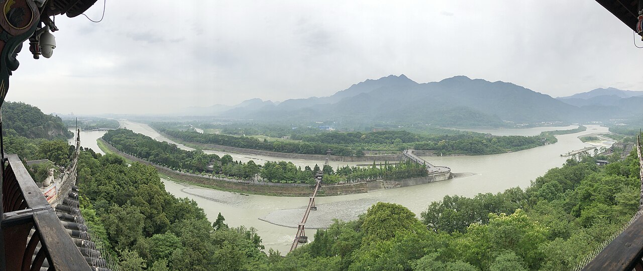
Mount Qingcheng and the Dujiangyan Irrigation System were jointly inscribed as a UNESCO World Heritage Site in 2000. The Dujiangyan dam complex on the Min River was designed by the Qin-dynasty engineer Li Bing around 256 BCE and has irrigated the Chengdu Plain continuously for 2,270 years, covering approximately 1.5 million hectares without sluice gates, pumps or electricity; the system works through a fixed channel-division geometry that allocates approximately 40% of river flow to the inner irrigation channel in dry season and 60% to the outer flood-diversion channel in wet season. Mount Qingcheng (1,260 metres), 15 kilometres southwest of the dam, has been a Taoist sacred site since at least the 2nd century BCE and contains 36 peaks and 108 scenic spots in a forested karst landscape accessed by cable car and a network of stone-paved trails.
Wolong and the panda mountains: a UNESCO wildlife sanctuary to the west 90 km west, 2 hours by road
The Sichuan Giant Panda Sanctuaries (UNESCO 2006) cover 924,500 hectares across the Qionglai and Jiajin Mountain ranges immediately west of the Chengdu Basin, with Wolong Nature Reserve (200,000 hectares) as the most accessible component, approximately 90 kilometres west of Dujiangyan by road via the G350 highway through Yingxiu, a journey of approximately 2 hours. The Qionglai range that contains Wolong is the same geological massif that Mount Qingcheng rises from; the terrain transitions westward from the forested karst of Qingcheng (elevation 1,260 metres) through the Longmen Shan fault zone into the Qionglai’s higher ridgelines, reaching 6,250 metres at Siguniang Mountain (Four Girls Mountain, 150 kilometres west of Dujiangyan), which is part of the panda sanctuary inscription boundary. The UNESCO inscription recognises 9 nature reserves and 14 nature parks across the Qionglai and Jiajin ranges as components of a single contiguous habitat corridor supporting approximately 30% of the world’s wild giant panda population; the 2021 national census counted 1,864 wild giant pandas across Sichuan, Shaanxi and Gansu provinces, up from 1,596 in the 2003 census. The ecological connection between the panda sanctuary and Dujiangyan is direct and historically documented: the Min River, which the Dujiangyan system diverts from the Longmen Shan range onto the Chengdu Plain, originates in the same mountain complex that the panda sanctuaries occupy. Li Bing’s 3rd-century BCE engineering works on the Min River at Dujiangyan transformed the river from a flood hazard into the irrigation source for one of China’s most productive agricultural regions; the same river above the diversion point continues to drain the Wolong and Qionglai forests. The Chengdu Research Base of Giant Panda Breeding (within Chengdu city, 30 kilometres east of Dujiangyan) is technically outside the UNESCO inscription boundary but is administratively linked to the panda sanctuary system and provides the most reliable opportunity to observe giant pandas in a semi-natural habitat setting; it currently houses approximately 50 pandas and is open year-round, with the best observation opportunities in the early morning (8:00–10:00 when feeding occurs) before midday inactivity. Combining Dujiangyan and the Chengdu Panda Base in a single Chengdu-based day trip is a practical half-day circuit: metro and Chengdu rail to Dujiangyan station (1 hour), visit the dam and Erwang Temple (2 hours), then Qingcheng front mountain cable car and temple circuit (2–3 hours), return to Chengdu for an early-morning panda base visit the following day.
South to Leshan and north to Huanglong: the Sichuan UNESCO arc 150–350 km, 2–8 hours
Mount Emei Scenic Area, including Leshan Giant Buddha Scenic Area (UNESCO 1996), is located approximately 150 kilometres south of Dujiangyan by road, reachable in approximately 2 hours by high-speed rail from Chengdu South station to Emeishan station or Leshan station. The inscription covers two connected sites: Mount Emei (3,099 metres), one of the four sacred Buddhist mountains of China, where the first Buddhist temples in China were built in the 1st century CE according to traditional accounts (the Baoguo Monastery at the mountain base dates in its current form to the 16th century); and the Leshan Giant Buddha at the confluence of the Dadu, Qingyi and Min rivers, 33 kilometres from the Emei summit, a Tang-dynasty Buddha figure 71 metres tall carved from a cliff of red sandstone between 713 and 803 CE under the supervision of the monk Haitong and his successors. The Leshan Buddha’s engineering is as deliberate as Dujiangyan’s: Haitong initiated the project because the confluence of three rivers at Leshan caused hydraulic turbulence that made the crossing dangerous for boats, and he believed that the weight of the carved Buddha would pacify the river currents; the quarrying of rock into the river during construction also raised the riverbed at the point of maximum turbulence. The practical result, documented in Tang administrative records, was that the confluence did become safer for navigation after the construction project altered the channel geometry, whether or not the theological explanation was accepted. Both the Dujiangyan system and the Leshan Buddha thus represent pre-industrial engineering interventions in river systems that produced measurable hydraulic effects through physical modification of the channel: one through diversion and geometry, one through bed elevation and flow modification. Huanglong Scenic and Historic Interest Area (UNESCO 1992) is located approximately 350 kilometres north of Dujiangyan by road via the G213 highway through Mao County, a journey of approximately 5–6 hours; from Chengdu, the full journey is approximately 480 kilometres (8 hours by road or 1 hour by flight to Jiuzhaigou/Huanglong Airport). Huanglong’s approximately 3,400 travertine pools at elevations between 3,400 and 5,100 metres represent the northern terminus of a geological arc that extends from the Chengdu Plain (elevation approximately 500 metres at Dujiangyan) up through the Longmen Shan fault zone, through the Wolong and Qionglai panda habitat, and into the high Minshan range of Huanglong. The 4,600-metre elevation difference between Dujiangyan and Huanglong’s summit spans four distinct climatic and ecological zones in a single straight-line distance of approximately 350 kilometres—a concentration that is unusual even by the standards of the eastern Tibetan Plateau transition zone. The Ancient Building Complex in the Wudang Mountains (UNESCO 1994) is approximately 800 kilometres east of Dujiangyan by high-speed rail via Chengdu East to Wudangshan station (approximately 6 hours via Chongqing and Shiyan or via Wuhan), making it the furthest inscribed site on a practical circuit from Dujiangyan but the most thematically contrasted: where Mount Qingcheng is a Taoist site that has accumulated hermits and small temples over two millennia in a forested mountain, Wudang is a Taoist site remade by imperial decree over 12 years beginning in 1412 CE into one of the largest monastic construction projects in Chinese history, with 53 surviving structures on 72 peaks.
Practical information
Dujiangyan city is 50 kilometres northwest of Chengdu, reached in approximately 1 hour by metro Line 6 to Chengdu Qintai Road station then transfer to the Chengdu–Dujiangyan city railway (expressway rail) to Dujiangyan station. The Dujiangyan heritage site (Erwang Temple and dam complex) is a 5-minute taxi ride from the station. Mount Qingcheng is 15 kilometres further southwest by bus (approximately 30 minutes) to the Qingcheng Front Mountain gate; the cable car ascends to the Shangqing Palace area and the walk to the summit (Lao Jun Pavilion, 1,260 metres) takes 1–2 hours from the cable car upper station. The rear mountain (Qingcheng Hou Shan) is a separate scenic area with wilder terrain and fewer visitors; an overnight stay at one of the rear mountain Taoist hermitages makes it accessible as a half-day walk. Dujiangyan and Qingcheng front mountain can be covered comfortably in one long day from Chengdu; the rear mountain requires a separate day or an overnight. The most detailed views of the Dujiangyan fish mouth and bottle-neck channel are from the Erwang Temple terrace above the channel and from the Anlan suspension bridge (147 metres long, pedestrian-only) that crosses the inner and outer channels at the point where the original bamboo-sausage dams (zhulong) that Li Bing used for temporary cofferdam construction were built. Replicas of the bamboo-sausage construction technique are demonstrated in the heritage interpretation area during the annual Qingming maintenance festival (early April), when the inner channel is drained for inspection and dredging in the traditional manner.
Chengdu is the practical base for all the sites in this article: Dujiangyan (1h rail), Wolong (2h road), Leshan/Emei (2h HSR), Huanglong (8h road or 1h flight). A logical 5-day Sichuan UNESCO circuit from Chengdu runs: Day 1 panda base (morning) + return; Day 2 Dujiangyan dam + Qingcheng; Day 3 Wolong; Day 4–5 Emei + Leshan, returning by HSR to Chengdu. Huanglong (and Jiuzhaigou) adds 3–4 days on a separate north arc from Chengdu, best done by flight to Jiuzhaigou/Huanglong Airport.
Frequently Asked Questions
How does the Dujiangyan system work without sluice gates and why has it not been replaced by a conventional dam?
The Dujiangyan system’s fundamental engineering insight is that a divided river channel in a curved reach will naturally distribute flow between its two branches in proportion determined by the geometry of the division—specifically, by the angle and depth of the dividing levee crest and the width of the channel downstream of the division. Li Bing (or the hydraulic tradition he inherited) recognised that the Min River at Dujiangyan curves around a spur of Yulei Hill at the point where it exits the Longmen Shan range onto the Chengdu Plain; in a curved channel, surface flow is directed to the outer bank (centrifugal effect) while bottom flow and sediment load are directed to the inner bank. By placing the Fish Mouth Levee (Yuzui) so that the outer branch became the inner irrigation channel and the inner branch became the outer flood-diversion channel, Li Bing arranged for the surface water (cleaner, with less sediment) to enter the irrigation network and for the bottom sediment load to flush down the outer channel during floods. The Bottle-Neck Channel (Baopingkou), cut through Yulei Hill spur at a precise width, acts as a fixed throttle on the inner channel’s capacity: at low flow it admits the full inner-channel quota; at high flow it chokes the excess back into the outer channel. No gates are required because the geometry itself performs the regulation. A conventional dam would have replaced this elegant system with higher-capacity water storage, but would also have submerged the Dujiangyan heritage site under a reservoir and disrupted the Min River’s sediment regime; the Chinese national heritage protection law classifies Dujiangyan as a protected historic site (guojia wenbo danwei), which prevents construction of any structure that would alter or inundate it. The Zipingpu Reservoir, built 9 kilometres upstream of Dujiangyan and completed 2005, augments dry-season water supply to the Chengdu Plain without replacing the Dujiangyan diversion function; its dam was identified in the post-2008 earthquake analysis as a possible contributing factor to the Wenchuan earthquake due to reservoir-induced seismicity, though this causal link remains contested in the scientific literature.
What is the religious significance of Mount Qingcheng in Chinese Taoism?
Mount Qingcheng is one of the earliest documented sites of organised Taoist religious activity in China. The mountain is associated with Zhang Daoling (34–156 CE), the founder of the Tianshi (Celestial Masters) tradition, who is said to have received a revelation from the deified Laozi (Lord Lao) on Heming Mountain near Chengdu and subsequently to have established his religious community in the Qingcheng area; some Taoist sources place Zhang Daoling’s death and ascension at Qingcheng itself. The Tianshi (Celestial Masters) tradition that Zhang Daoling established became one of the two main streams of organised Taoism (alongside the Quanzhen school of the 12th century CE), and its headquarters were located at Qingcheng from Zhang Daoling’s time through several generations of his descendants (the Zhang family transmitted the patriarchate down to the 64th Celestial Master, who died in Taiwan in 2008). The mountain’s 36 peaks and its forested landscape of ancient cypresses (several specimens over 1,000 years old, the oldest over 1,800 years according to tree-ring dating) are framed in the Taoist tradition as a concentrated expression of the natural patterns (Dao) that the hermit tradition sought to observe and embody. The Tianshi cave (Tianshi Dong), a rock hermitage high on the mountain where Zhang Daoling is said to have meditated, is the primary pilgrimage site; the current temple structure at the cave dates to the Tang dynasty in its original conception and to the Qing dynasty (1644–1912) in its present form. The rear mountain (Qingcheng Hou Shan) preserves a wilder landscape with fewer visitors and several active hermitages where Taoist priests in residence follow a daily schedule of ritual, meditation and physical cultivation practice; the Taoist medical tradition associated with Qingcheng, particularly the use of mountain herbs in formulas attributed to Zhang Daoling, continues to be practiced by the resident monastic community.
What is the Leshan Giant Buddha and how does it compare to other large Buddhist figures worldwide?
The Leshan Giant Buddha is a seated Maitreya (Future Buddha) figure carved from the red sandstone cliff at the confluence of the Dadu, Qingyi and Min rivers in Sichuan Province, begun in 713 CE and completed in 803 CE under Tang-dynasty patronage. At 71 metres from crown to foot it was, at the time of completion, the tallest stone Buddha in the world; it held that status until 2008, when the Spring Temple Buddha in Henan Province (153 metres to the crown of the statue, 208 metres including the base and throne) was completed as a modern construction. The Leshan figure is a sitting Buddha, which affects the measurement: a standing figure of equivalent proportions would reach approximately 141 metres; the seated posture was chosen partly for structural reasons (a sitting figure concentrates load vertically through the hips and base rather than through the ankles of a standing figure, reducing the cantilever stress on the carved stone at the ankle point). The figure’s construction records, preserved in the Tang official histories and in the biography of the monk Haitong, document a 90-year construction period interrupted by funding crises and by the death of Haitong himself; Haitong is recorded as having gouged out his own eyes to convince a corrupt official that he would not allow the project funds to be diverted, an act that caused the official to desist. The drainage system integrated into the figure—drainage channels hidden in the folds of the robe, hair and behind the ears that divert rainwater away from the carved surface to prevent erosion—is cited in the UNESCO inscription as an example of the engineering sophistication of Tang-period large-scale stone sculpture. The figure faces east toward the confluence, and its toes are level with the original river surface, making the scale readable from a boat: visitors approach by ferry from the Leshan landing to view the figure from the river, a perspective that makes the 71-metre height immediately legible in relation to the cliff and the surrounding trees.
Sources
- S1 — UNESCO World Heritage Centre — Mount Qingcheng and the Dujiangyan Irrigation System (Ref. 1001) — https://web.archive.org/web/20230601000000/https://whc.unesco.org/en/list/1001/
- S2 — Dujiangyan Scenic Area Management Bureau — https://whc.unesco.org/en/list/1001/
- S3 — Kuhn, Dieter. <em>The Age of Confucian Rule: The Song Transformation of China</em>. Harvard University Press, 2009. ISBN: 978-0-674-03661-1.
Spotted an error? Write to editorial@culturalheritageonline.com and we correct it the same day.