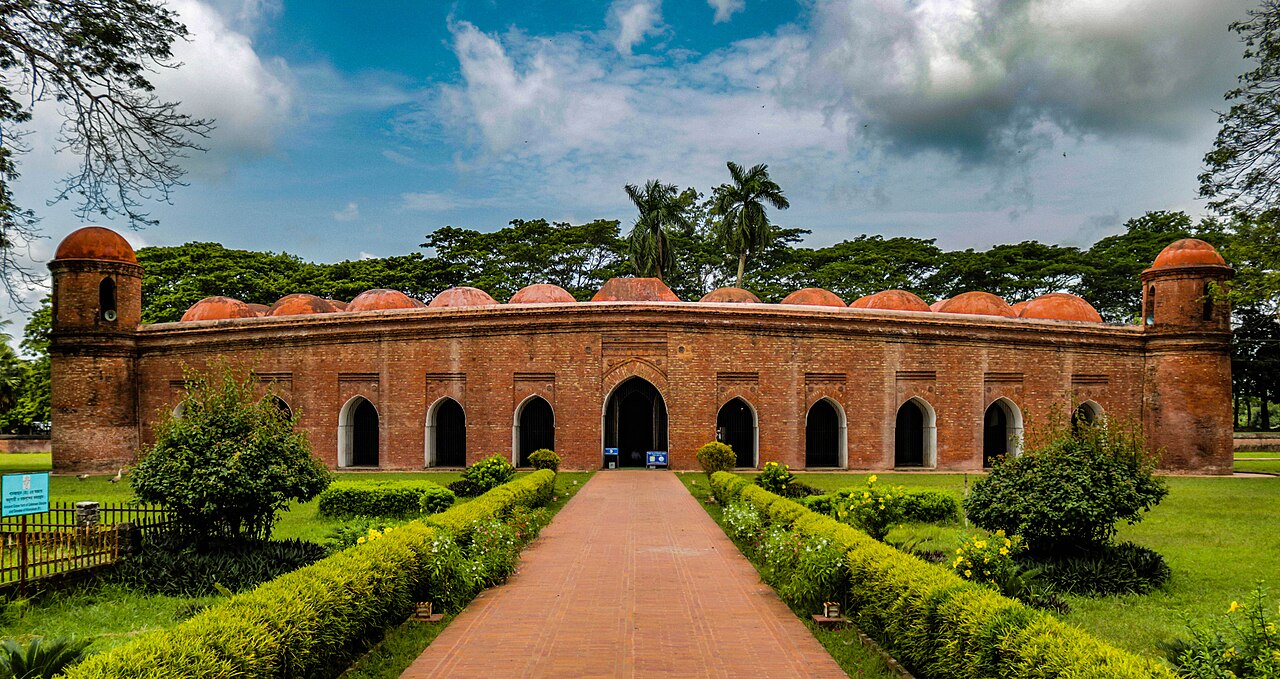
In the mid-15th century, a Turkish military commander named Khan Jahan Ali built an entire Islamic city in the Bengal Delta — more than 360 mosques, tanks, tombs, and bridges across roughly 7 square kilometres. He died around 1459 CE, and within decades the jungle swallowed the city whole. Nineteenth-century British surveyors found it again, and in 1985 UNESCO added the Mosque City of Bagerhat, also known as Khalifatabad, to its World Heritage List.
A city built in a decade and lost for four centuries Khulna Division, Bangladesh
Khan Jahan Ali arrived in Bengal from Central Asia as part of the broader Islamisation of the subcontinent that was reshaping the eastern Gangetic plain in the 14th and 15th centuries. His credentials were military — he served as a high-ranking commander — but in the Bengal Delta he turned his energies to civic construction on a scale that was extraordinary even by the standards of Sultanate-era cities. The city he built, Khalifatabad, occupied a strategic node between the delta’s rivers and the forests of what would later become the Sundarbans.
The construction material was fired terracotta brick, which was abundant and practical in an alluvial landscape with no local stone. Khan Jahan’s builders used it for everything: mosques with multi-cusped arches and terracotta-relief panels, dhighi (large rectangular tanks for drinking water and ritual use), and causeways linking the city’s components across seasonally flooded terrain. Surviving tanks include Ghora Dighi, which stretches over 1.5 kilometres. The city’s water infrastructure was as carefully planned as its religious architecture — without the tank system, a population of this size could not have survived in the delta.
After Khan Jahan Ali died c. 1459, no successor arose to maintain the city’s administrative coherence. The population dispersed, the tanks silted, and the jungle advanced. For roughly four centuries Khalifatabad existed only in local oral tradition and in scattered references in Persian chronicles. British colonial surveys beginning in the 1860s started to map what was actually on the ground — and found dozens of mosque ruins, tank embankments, and brick-paved roads extending far beyond any single monument.
Today the core protected zone covers approximately 7 square kilometres, but the full extent of brick-paved roads and tank systems is considerably larger. The Archaeological Department of Bangladesh manages the site, and visitors can walk between the major monuments in a single day — though the full infrastructure of Khalifatabad rewards more time. The town of Bagerhat itself, the modern settlement adjacent to the site, is reached by road from Khulna, 55 km to the north, in about 90 minutes.
The Sixty Dome Mosque’s 77 domes and the crocodiles in Khan Jahan’s tank Bagerhat, Khulna Division
The most substantial surviving structure is universally called the Sixty Dome Mosque — Shat Gambuj Masjid in Bengali — though counting reveals 77 domes on its roof, arranged in 11 rows of 7. The name refers not to the domes but to the 60 stone pillars that support the roof from the interior, forming a forest of columns unlike anything else in medieval Bengali architecture. The pillars are basalt, imported at considerable logistical cost to a region where stone does not occur naturally. The mosque measures approximately 49 metres by 33 metres in plan, making it the largest medieval mosque in Bangladesh.
Construction is dated to 1459 CE based on inscriptions. The terracotta brick exterior carries moulded decoration around the arches, and the multi-cusped profile of each arch reflects a regional Bengali style that would persist in mosque design for another two centuries. The interior, with its columnar rhythm and dim light filtering through stone screens in the south wall, has a character closer to a hypostyle hall than to the open-plan mosques of the Arab world — a regional adaptation to a climate where shade and cross-ventilation matter more than prospect.
Two kilometres from Shat Gambuj, the Tomb of Khan Jahan Ali occupies a small complex around a tank called the Thakur Dighi. The nine-domed tomb mosque is smaller and more intimate than Shat Gambuj, but it functions very differently: the tomb remains an active pilgrimage site. Visitors come to pray and to make offerings, and the adjacent tank is home to two estuarine crocodiles — fed by custodians as holy animals associated with the saint. The tradition of treating the crocodiles as sacred is centuries old; the animals are docile by habit and have been replaced, when one dies, by another brought from the Sundarbans.
Other surviving structures in the Bagerhat complex include the Bibi Begni Mosque, the Chunakhola Mosque (notable for its nine domes and refined terracotta ornament), and the Ronvijoypur Mosque, which is a single-domed structure thought to be one of the largest single-dome mosques in Bangladesh. Together they document an architectural programme sustained over at least two decades of intensive building.
Regional context: the Sundarbans, Paharpur, and Dhaka Within 300 km
The Sundarbans mangrove forest begins approximately 60 km south of Bagerhat and forms an obvious pairing for any itinerary focused on the Khulna Division. Listed by UNESCO in 1997 (the Indian portion was listed separately in 1987 as Sundarbans National Park), the Sundarbans cover a total of around 10,000 square kilometres across both countries. The Bangladesh portion — 6,017 sq km — is the larger share. Access is entirely by boat; there are no roads inside the forest. Khulna is the standard gateway for launches heading into the Sundarbans, and the combination of Bagerhat’s brick mosques and the boat-accessed mangroves makes for a coherent two- to three-day programme from a Khulna base.
Three hundred kilometres to the north lies Paharpur (UNESCO 1985), the ruins of the Somapura Mahavihara, a Buddhist monastery built by the Pala emperor Dharmapala in the late 8th century CE. Where Bagerhat represents the Islamic architecture of the Bengal Sultanate, Paharpur represents the Buddhist monastic tradition that preceded it — and that was violently ended when Bakhtiyar Khilji burned the Bengal monasteries in 1203. The journey between the two sites takes a full day overland or slightly less by a combination of rail and road via Rajshahi.
Dhaka, the capital, lies roughly 200 km northeast of Bagerhat. The city’s Lalbagh Fort, begun in 1678 under Mughal Governor Prince Azam Shah (son of Aurangzeb) and never completed, represents the third major layer of Islamic architectural history in Bangladesh after the Bagerhat Sultanate and the transitional Mughal period. The fort’s Pearl Mosque, the tomb of Bibi Pari with its marble inlay, and the Diwan-i-Aam audience hall are worth several hours of careful attention.
Practical information
Bagerhat is accessible from Dhaka by bus (approximately 5–6 hours, change at Khulna or take direct services on the Dhaka–Khulna highway). From Khulna, local buses and auto-rickshaws cover the 55 km in roughly 90 minutes. There is no commercial air service to Bagerhat; the nearest airport is Jessore (Jashore), about 80 km north, which has daily flights from Dhaka.
The Mosque City monuments are managed by the Bangladesh Department of Archaeology. Admission fees apply for foreign visitors; combined tickets for the main monuments are available at the Shat Gambuj ticket office. Opening hours are generally 09:00–17:00; the ticket office closes earlier in winter (October–February). The site is fully outdoors and exposed to sun — appropriate clothing and water are essential in summer (April–June), when temperatures regularly exceed 35°C and humidity is high.
The best time to visit is November to February (dry season, temperatures 15–25°C). March–May brings pre-monsoon heat. June–October is monsoon season; the tank system is full and the brickwork is photographically striking in low light, but some paths flood. Accommodation is limited in Bagerhat town; most visitors stay in Khulna (budget guesthouses through mid-range hotels) and visit on a day trip.
Frequently Asked Questions
Why does the Sixty Dome Mosque have 77 domes if it is named for sixty?
The name Shat Gambuj — literally “sixty-domed” in Bengali — refers to the 60 basalt stone pillars that support the roof from the interior, not to the number of domes on the roof itself. The roof carries 77 domes arranged in 11 rows of 7. This counting discrepancy has been noted since colonial-era surveys and is simply a naming convention that attached itself to the most visible feature of the structure — the interior columns — rather than to the domes above. The pillars are themselves remarkable: basalt does not occur in the Bengal Delta, which is entirely alluvial sediment to great depth, so the stone was transported overland or by river from quarries at considerable distance, a logistical effort that speaks to Khan Jahan Ali’s resources and organisational capacity.
Who was Khan Jahan Ali, and why did he build a city in the Bengal Delta?
Khan Jahan Ali was a Turkish military commander who came to Bengal likely in the service of the Bengal Sultanate in the early 15th century. His exact origin is debated — some sources describe him as a Sufi saint as well as a military figure, and his role in the Islamisation of the region was as much religious as administrative. He appears to have governed the Bagerhat region with considerable autonomy from the Bengal Sultanate’s main power centre at Gaur (in present-day West Bengal), building Khalifatabad as a fully functional Islamic city with its own water supply, roads, and places of worship. After his death around 1459, there was no successor of comparable authority, and the city’s administrative and maintenance functions collapsed within a generation. He is venerated as a Muslim saint (wali), and his tomb remains a pilgrimage destination today, drawing visitors who regard him as both a religious figure and a founding ancestor of Islamic culture in the Bengal Delta.
How does the Mosque City of Bagerhat relate to the Sundarbans ecosystem?
The two UNESCO sites — Bagerhat (1985) and the Sundarbans (1997) — share the same Khulna Division and lie approximately 60 km apart, but they represent very different relationships to the delta landscape. Khalifatabad was built on slightly higher ground at the northern edge of the delta, where the seasonal flooding could be managed with tanks and causeways but where permanent habitation was viable. The Sundarbans, by contrast, occupy the active delta where river sediment deposition, tidal influence, and sea-level dynamics make permanent settlement impossible for most species except those adapted to saline inundation. When Khalifatabad was abandoned after Khan Jahan’s death, the jungle that reclaimed it was proto-Sundarban vegetation — the same tidal forest ecosystem that, further south, now forms the world’s largest mangrove complex. The city was thus lost not to simple neglect but to the same ecological force that the Sundarbans represents at its fullest expression: the Bengal Delta’s relentless tendency to reassert forest cover wherever human maintenance ceases.