Ayutthaya was founded in 1351 by King U Thong on a river island at the confluence of the Chao Phraya, Pa Sak, and Lopburi rivers, 80 kilometres north of present-day Bangkok. Over 417 years it served as the capital of the Siamese kingdom under 33 kings, growing to an estimated population of one million by 1700 — larger than London at the same date. On 7 April 1767, after a two-day assault, Burmese forces entered the city, executed or enslaved the population, and burned the royal palace and temples, ending the Ayutthaya kingdom permanently.
Wat Phra Si Sanphet and the Architecture of the Ayutthaya Kingdom Ayutthaya Historical Park: 80 km north of Bangkok, 1 hour 30 min by train
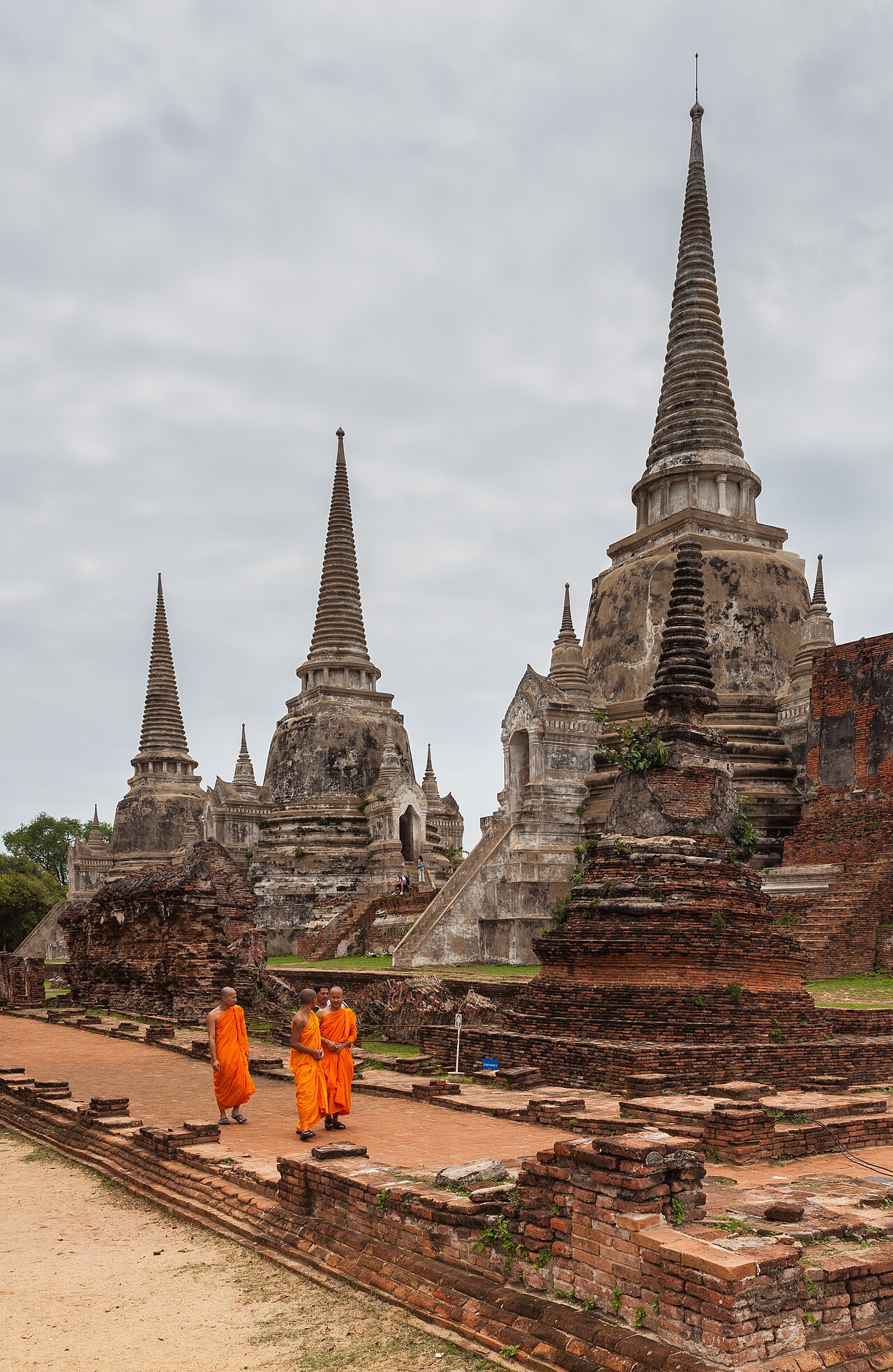
Ayutthaya Historical Park, inscribed as a UNESCO World Heritage Site in 1991, covers the central island of the former capital and contains the most concentrated ensemble of ruins. The park’s signature structure, Wat Phra Si Sanphet, occupied the site of the original royal palace before King Borommatrailokanat moved the palace further north in the 15th century and converted the former palace grounds into a royal temple. Three bell-shaped chedis were built in sequence — the first in 1492, the second in 1499, and the third in 1503 — to enshrine the cremated ashes of King Borommatrailokanat, his son King Borommarachathirat III, and his grandson King Ramathibodi II respectively. The chedis were restored in the 1950s; the restorations are visible in their regular brickwork, which contrasts with the weathered original sections at the bases.
Ayutthaya’s urban layout was organised around three principal artificial canals that connected the three rivers surrounding the island, creating a fortified circuit approximately 12 kilometres in circumference. Within this perimeter, the city contained approximately 400 temples at the height of its prosperity, according to accounts by Dutch, French, and Japanese merchants who visited in the 17th century. The Dutch East India Company (VOC) maintained a trading post at Ayutthaya from 1605 to 1767; Japanese and Chinese merchant communities occupied permanent quarters within the city. The cosmopolitan character of the city in the 1600s is documented in detail in the accounts of French diplomat de La Loubère, whose 1691 work “Du Royaume de Siam” remains one of the most detailed external descriptions of Ayutthaya at its peak.
The Burmese destruction of 1767 was not the kingdom’s first encounter with Burmese forces: Ayutthaya was besieged and briefly occupied by the Toungoo dynasty in 1569 but recovered its independence under King Naresuan. The 1767 destruction, however, was total. Melted gold from the Buddha statues was poured off to transport; temples were burned; royal archives were destroyed. The subsequent Siamese kingdom relocated its capital first to Thonburi and then to Bangkok under the Chakri dynasty (founded 1782). Ayutthaya was never rebuilt as a functioning city; the ruins were left in place, and much of the area was used for agriculture until the 20th century.
The Fine Arts Department of Thailand began systematic excavation and conservation at Ayutthaya in the 1950s. Current conservation challenges include the site’s susceptibility to flooding — the surrounding rivers regularly inundate the low-lying ruins — and the impact of tourism, which reached approximately 3 million visitors per year before 2020. Several monuments within the historical park, including the reclining Buddha at Wat Lokayasutharam (49 metres long) and the headless Buddha torsos at Wat Mahathat, are among the most photographed subjects in Thailand.
Sukhothai, Si Satchanalai and Ban Chiang: Earlier Kingdoms and Bronze Age Origins Sukhothai 340 km north; Ban Chiang 500 km northeast
Sukhothai Historical Park, inscribed alongside Ayutthaya on the UNESCO World Heritage List in 1991 under a separate nomination, lies 340 kilometres north of Ayutthaya. Founded in 1238, Sukhothai was the first independent Thai kingdom — Ayutthaya’s predecessor and eventual rival. Sukhothai’s peak territory extended from the Mekong River to the Malay Peninsula under King Ramkhamhaeng (r. 1279–1298), who is credited with the invention of the Thai script in 1283. The Sukhothai kingdom was absorbed into the Ayutthaya kingdom in 1438, when its last king submitted to Ayutthayan sovereignty.
The ruins at Sukhothai Historical Park cover approximately 70 square kilometres and include 193 identified monuments. The central temple, Wat Mahathat, was the royal temple of the Sukhothai kingdom; its distinctive lotus-bud (mahadhatu) chedis represent a form unique to Sukhothai and distinguishable from the bell-shaped chedis of Ayutthaya and the prang-style towers of Lopburi. Wat Mahathat’s central stupa is surrounded by a moat and flanked by laterite columns that once supported the roof of an open pillared hall.
Si Satchanalai-Chaliang, a satellite city of the Sukhothai kingdom, is inscribed as part of the same UNESCO listing and lies 57 kilometres north of Sukhothai town. Si Satchanalai produced the famous Sawankhalok ceramics — celadon and underglaze-painted wares that were exported across maritime Southeast Asia from the 14th through 16th centuries. Archaeological evidence of Sawankhalok kilns has been found at sites in the Philippines, Indonesia, Borneo, and Japan, attesting to the reach of the Sukhothai kingdom’s trade networks. Over 200 kiln sites have been identified around Si Satchanalai; the kilns used wood-firing techniques that produced the distinctive grey-green glaze characteristic of Sawankhalok ware.
Ban Chiang, 500 kilometres northeast of Ayutthaya in Udon Thani Province, represents a fundamentally different time horizon. Inscribed as a UNESCO World Heritage Site in 1992, Ban Chiang is the most significant Bronze Age site in mainland Southeast Asia. Excavations have documented continuous habitation from approximately 3600 BCE to 200 CE, with evidence of bronze metallurgy dating to approximately 2000 BCE — placing the Ban Chiang culture among the earliest bronze-working societies anywhere in the world. Painted pottery found at the site shows a distinctive swirling geometric style; human burials were conducted with grave goods including pottery, bronze implements, and glass beads. The National Museum at Ban Chiang, located on the excavation site, displays in-situ burials and artefacts in their original stratigraphic positions.
Practical information Ayutthaya: 80 km north of Bangkok via train (Hua Lamphong/Krung Thep Aphiwat) or bus
Ayutthaya is the most accessible UNESCO site from Bangkok: trains run from Krung Thep Aphiwat (Bang Sue) Central Station approximately every 30 minutes; the journey takes 1 hour 20 minutes to 1 hour 45 minutes depending on the service. No advance booking is required for third-class seats (approximately 20 THB); second-class is recommended for longer journeys. Tuk-tuks and bicycle rental are available at the Ayutthaya station for reaching the historical park (2 km from the station).
The Ayutthaya Historical Park entrance is free; individual temple sites charge separate fees (typically 50 THB each). Wat Phra Si Sanphet and Wat Mahathat are the two sites with the largest volume of visitors. The best light for photography is early morning (07:00–09:00) or late afternoon (16:00–18:00). November through February (cool season) is optimal for both comfort and access. The river floods that regularly affect the ruins are typically worst in October; some low-lying sections of the park may be inaccessible after heavy monsoon rains.
Reaching Sukhothai from Ayutthaya requires a bus or train journey of approximately five hours northbound. The historical park is 12 km west of the modern Sukhothai town (renamed New Sukhothai); songthaew (shared pick-up trucks) connect the two. Ban Chiang is most conveniently reached from Udon Thani, served by flights from Bangkok (approximately 1 hour). Thai baht (THB) is the currency; exchange facilities are available at Bangkok airports and throughout Ayutthaya. No visa is required for citizens of most countries for stays up to 30 days under Thailand’s visa-exemption scheme; check the current list of eligible nationalities before travel, as conditions change periodically.
Frequently Asked Questions
What exactly happened during the Burmese sack of Ayutthaya in 1767, and why was the city never rebuilt?
The Burmese kingdom of Konbaung, under King Hsinbyushin, besieged Ayutthaya in August 1766 with a force estimated at between 40,000 and 60,000 troops. The siege lasted approximately eight months before the city’s outer defences collapsed. The two-day final assault on 7–8 April 1767 resulted in the capture of the city; the reigning Siamese king, Ekkathat, died shortly after — possibly in hiding, possibly of starvation during the siege. Contemporary Burmese chronicles record the destruction of the royal palace, the temples, and the royal archives. Gold was stripped from Buddha statues and from the gilded spires of the major temples. An estimated 30,000 to 90,000 Siamese were killed or enslaved and transported to Burma; the number varies widely between sources and is difficult to verify archaeologically. The city was not rebuilt for several reasons: the Siamese military leader who expelled the Burmese forces within seven months (Taksin) was based at Thonburi near the Gulf of Thailand, and he chose that location as his capital for strategic reasons related to maritime defence. When the Chakri dynasty succeeded Taksin in 1782, they moved the capital one kilometre across the river to Bangkok, where the riverine defences and access to the sea were considered superior. Ayutthaya’s island site, while defensively strong, had proven vulnerable to prolonged siege, and returning there carried associations with political defeat. The ruins were thus left undisturbed, providing one of the most complete archaeological records of a pre-modern Southeast Asian capital anywhere in the region.
What is the significance of Ban Chiang for understanding the prehistory of Southeast Asia?
Before excavations at Ban Chiang began in 1967 (following a discovery by American anthropologist Steve Young) and were expanded under a Thai Fine Arts Department and University of Pennsylvania joint programme in 1974–1975, the conventional academic view held that bronze-working in Southeast Asia derived from diffusion from China or the Near East, reaching the region no earlier than 500 BCE. The radiocarbon dates produced from Ban Chiang’s lower stratigraphic levels — placing bronze artefacts at around 2000 BCE and pottery at around 3600 BCE — were initially controversial and were subjected to extensive methodological critique through the 1980s. Subsequent re-dating using improved AMS radiocarbon techniques and thermoluminescence dating of the painted pottery has broadly confirmed early dates in the range of 2100–1500 BCE for the earliest bronze at the site, though the debate about whether Ban Chiang represents independent invention or early transmission of bronze technology from elsewhere in Asia continues in academic literature. What is not disputed is the complexity and longevity of the Ban Chiang culture: 18 seasons of excavation have documented a society that manufactured socketed bronze tools, produced highly refined painted ceramics in multiple distinct styles, and maintained a subsistence economy based on rice cultivation and the herding of cattle and pigs over more than 3,500 years of continuous occupation.
How do the three sites in the Sukhothai UNESCO listing — Sukhothai, Si Satchanalai, and Kamphaeng Phet — relate to each other?
The UNESCO inscription of 1991 covers what Thailand designated as the “Historic Town of Sukhothai and Associated Historic Towns,” encompassing three separate sites within the same nomination file. Sukhothai was the political and religious capital of the Sukhothai kingdom at its height in the 13th–14th centuries. Si Satchanalai-Chaliang, 57 km north, functioned as a secondary royal city and the centre of ceramic production; its kilns supplied the export trade that funded part of the kingdom’s economy. Kamphaeng Phet, approximately 70 km southwest of Sukhothai, was a military fortification city on the kingdom’s southern frontier, serving as the first line of defence against expansion from the Ayutthayan polity to the south. All three show a consistent architectural vocabulary — laterite construction, lotus-bud chedis, laterite pillared halls — that distinguishes Sukhothai-period building from earlier and later Thai architectural styles. Of the three, Si Satchanalai is considered by many archaeologists to have the better-preserved ruins: its remoteness from the modern road network and from major tourism infrastructure meant it was not subjected to the clearing and “restoration” work that modified many of the central Sukhothai monuments in the 20th century. Some of the kilns at Si Satchanalai are still visible as earthen mounds, and the surrounding forests retain trees that pre-date modern settlement of the area.