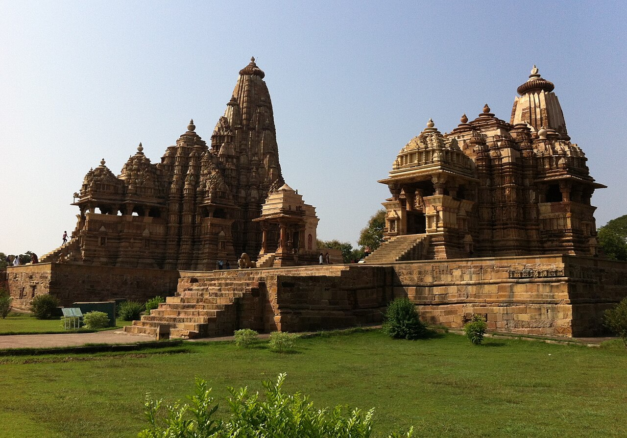
The Khajuraho Group of Monuments is a complex of 25 surviving Hindu and Jain temples in Chhatarpur district, Madhya Pradesh, built by the Chandela dynasty between approximately 950 and 1050 CE. The temples were abandoned following the decline of the Chandela dynasty under pressure from the Delhi Sultanate in the 13th century, overgrown by jungle, and not documented by European observers until T.S. Burt’s 1838 survey. UNESCO inscribed the site in 1986.
The Chandela Dynasty and the Construction of 85 Temples Chhatarpur District, Madhya Pradesh
The Chandelas were a Rajput dynasty who ruled Bundelkhand in central India from approximately 831 CE. Their capital was at Mahoba, but Khajuraho functioned as their religious and ceremonial centre — a sacred precinct separate from the political and military hub of the kingdom. Between approximately 950 and 1050 CE, successive Chandela rulers commissioned an extraordinary building programme: approximately 85 temples spread across a 6 km² site that includes three geographic clusters, now designated as the western, eastern, and southern groups.
The western group, within the main archaeological precinct managed by the Archaeological Survey of India, contains the largest and most architecturally complete temples. The eastern group includes both Hindu and Jain temples built within and around the present-day town of Khajuraho. The southern group, the smallest and most dispersed, contains two principal temples of significant quality.
The Chandela political situation deteriorated sharply in the late 12th century. Raids by Muhammad of Ghor in 1196 and subsequent campaigns by the Delhi Sultanate pushed the dynasty from its territories. Khajuraho, without a resident court to maintain it, was gradually abandoned. The jungle of central India — dense, fast-growing, and persistent — enclosed the stone structures. By the early 19th century, the temples were not unknown to local populations, but they had no presence in any European or Mughal administrative record as a functioning site. In 1838, T.S. Burt, a British engineer conducting survey work in the region, made the first documented European account of the temples. His report prompted further investigation, and the site entered the colonial-era consciousness of Indian antiquities.
Today 25 of the original 85 temples survive to a condition that permits meaningful study. The attrition — 60 temples lost over roughly 800 years — reflects both deliberate removal of building material by later inhabitants and the slow collapse of structures without maintenance. The surviving 25 are nevertheless sufficient to give a complete picture of the Chandela architectural programme in its mature phase.
The architectural style throughout is Nagara — the North Indian form of Hindu temple architecture characterised by a curvilinear tower (shikhara) over the sanctum, a succession of halls leading from the entrance porch (ardha-mandapa) through the assembly hall (mandapa) to the vestibule (antarala) and sanctum (garbhagriha). At Khajuraho, the Nagara form is taken to a specific regional elaboration in which multiple subsidiary towers (urushringas) cluster around the main shikhara, creating a rising composition that evokes the form of a mountain range rather than a single peak.
The Kandariya Mahadeva Temple and the Carvings: What 10% Actually Means Western Group, Khajuraho
The Kandariya Mahadeva Temple, built around 1025 CE and dedicated to Shiva, is the largest surviving structure at Khajuraho. Its shikhara reaches 30.5 metres, and the exterior carries approximately 900 individual carvings. The temple represents Mount Meru — the cosmic mountain at the centre of Hindu cosmology — in architectural form: the successive rising towers of the composition correspond to the mountain’s multiple peaks, and the sanctum beneath the highest shikhara is the cave at the mountain’s heart where the deity resides.
The erotic sculptures at Khajuraho are among the most discussed elements of the site in popular accounts, and among the most frequently misrepresented. The accurate figure, established by art-historical survey of the surviving temples, is that approximately 10% of the total carvings at Khajuraho depict erotic or explicitly sexual subjects. The remaining 90% depict mythological scenes, celestial nymphs (apsaras) in various poses, warriors, animals, processions, and scenes from daily life including musicians, acrobats, and hunters.
The erotic panels occupy a specific and architecturally meaningful position. They are placed on the outer walls at the level of the shikhara base — the transitional zone between the earthly lower registers of the temple and the ascending celestial registers above. This placement is not arbitrary. In the cosmological logic of the Nagara temple, the outer walls narrate the world of samsara — desire, action, and embodied existence — while the interior and the ascending tower represent liberation (moksha). Passing through the outer realm into the sanctum is a symbolic journey from attachment to release.
Multiple scholarly interpretations of the erotic programme exist. One tradition sees the panels as Tantric in character — representations of kundalini energy and the union of Shakti and Shiva as cosmic principles. Another treats them as apotropaic, protecting the temple from malevolent forces by their power. A third, widely supported in recent scholarship, reads them as narrative depictions of the realm of desire from which the devotee is symbolically released upon entering the temple. The colonial-era emphasis on the erotic panels — in some 19th and early 20th century accounts, they dominated descriptions of the entire site — reflects the priorities of European observers rather than the proportional reality of the sculptural programme.
The Kandariya Mahadeva carries 84 erotic figures among its approximately 900 carvings. For the Lakshmana Temple (930–950 CE), the figure is somewhat higher proportionally, but across the site as a whole the 10% ratio holds. Any account that presents Khajuraho primarily as an “erotic temple complex” is describing a fraction of the site through a lens determined by colonial attention rather than the actual content of the monuments.
Practical information
Khajuraho is in Chhatarpur district, Madhya Pradesh, roughly 620 km from Delhi and 280 km from Bhopal. The nearest airport is Khajuraho Airport (HJR), with direct flights from Delhi, Varanasi, and Agra. The nearest major rail junction is Mahoba (60 km), with connections to Jhansi on the main Delhi–Chennai line. From Jhansi (175 km), buses and taxis connect to Khajuraho.
The Archaeological Survey of India manages the western group within a fee-entry precinct (entry for foreign nationals: ₹600 as of 2024; Indian nationals: ₹40). The eastern and southern group temples are accessible without an entrance fee though some require a separate small admission. The Sound and Light Show at the western group runs in the evening in English and Hindi. The site is open sunrise to sunset. The nearest major accommodation is concentrated in Khajuraho town, within 2 km of the western group. April to February is the main visiting season; March to May are very hot (above 40°C).
There are no directly adjacent UNESCO World Heritage Sites. The closest inscribed property is the Buddhist Monuments at Sanchi, approximately 285 km southwest via Sagar. Orchha, a historic Bundela dynasty town with significant Mughal-period architecture, is 175 km west and while not itself UNESCO-inscribed, offers architectural context for the regional history.
Frequently Asked Questions
Why were the Khajuraho temples abandoned for 800 years?
The abandonment of Khajuraho followed the military decline of the Chandela dynasty in the late 12th and 13th centuries. The Delhi Sultanate, under Muhammad of Ghor and subsequent rulers, conducted campaigns into Rajput-held central India. The Chandelas lost effective control of their territories, and without a functioning court to maintain Khajuraho as a ceremonial centre, the site lost both the patronage and the institutional structure that kept it active. The temples were not destroyed in the manner of some sites — the primary cause of their obscurity was abandonment rather than deliberate demolition. The surrounding jungle, typical of the Vindhya-Satpura ecological zone, enclosed the stone structures gradually. Local populations in the region were aware of the temples, and some smaller shrines may have maintained intermittent local worship, but the site had no presence in Mughal administrative records and no European documentation prior to T.S. Burt’s 1838 account. Burt was a civil engineer conducting a geographical survey when he encountered the temples. His written record prompted further surveys by the Archaeological Survey of India under Alexander Cunningham, who conducted the first systematic documentation in the 1860s. The formal inscription of the site, excavation, and conservation programme developed through the late 19th and 20th centuries, culminating in the UNESCO inscription in 1986.
What is the Nagara style of temple architecture, and how does Khajuraho exemplify it?
The Nagara style is the dominant form of Hindu temple architecture in northern India, characterised by a curvilinear shikhara (tower) rising over the sanctum (garbhagriha) that houses the main deity. The term Nagara, derived from the Sanskrit word for city or urban, distinguishes North Indian temple forms from the Dravida style of South India (characterised by pyramidal gopura gateway towers) and the Vesara style of the Deccan (a synthesis of the two). The Nagara shikhara is structurally a pile of diminishing horizontal courses of stone whose outer face is carved to give the impression of a smooth upward curve, often likened to a mountain or a corn cob. At Khajuraho, the local elaboration of the Nagara style adds subsidiary towers (urushringas) clustered around the main shikhara, creating a composition in which multiple peaks rise in a coordinated ascent rather than a single tower. This variant is sometimes called the Chandela or Madhya Pradesh school of Nagara architecture. The effect of the urushringas is to give the exterior a dynamic, multi-layered profile when seen from any angle, while reinforcing the symbolic association with Mount Meru — the cosmic mountain understood in Hindu cosmology as having multiple peaks surrounding a central summit. The Kandariya Mahadeva Temple represents this approach at its most fully developed.
Are the Jain temples at Khajuraho part of the same complex as the Hindu temples?
The Jain temples at Khajuraho form part of the broader UNESCO-inscribed site but are geographically distinct from the main Hindu temples of the western group. They are located primarily in the eastern cluster, within and near the present-day town of Khajuraho. The principal Jain temples — the Parsvanatha, Adinatha, and Shantinatha temples — date from the same Chandela period (10th–11th centuries CE) and are architecturally related to the Hindu temples in their use of the Nagara style and similar sculptural programmes. The Parsvanatha Temple, the largest Jain temple at the site, carries carvings that include apsaras and narrative scenes very similar to those on the Hindu temples, suggesting the same workshops and craftsmen served both religious communities under Chandela patronage. The Jain community at Khajuraho has maintained an unbroken connection with these temples: unlike the Hindu temples, which passed through a period of complete abandonment, the eastern Jain temples had intermittent local use. Some remain active places of worship today and are managed partly by the local Jain community and partly by the ASI.