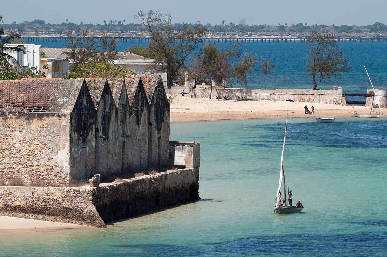
The Island of Mozambique is a coral island 3.5 kilometres long and between 200 and 500 metres wide, connected to the northern Mozambican mainland by a two-lane bridge of the same length. It has approximately 12,000 inhabitants and contains the oldest surviving European fort in sub-Saharan Africa, a church built in 1522 that is the oldest standing church on the continent south of the Sahara, and four centuries of Indian Ocean trade layered into its architecture. UNESCO inscribed it in 1991. The island gave its name to the country.
From Musa al-Biq to the Spice Route Capital: How a Coral Island Named a Nation Nampula Province, northern Mozambique — 3 km offshore, 180 km from Nampula city
The name “Mozambique” derives from this island, not the other way around. When Vasco da Gama arrived in March 1498 during the first European voyage from the Atlantic to India, the island was already a significant settlement within the Swahili-Arab Indian Ocean trading network. Its ruler was a local sultan whose name the Portuguese recorded as “Mussa Milique” or “Musa al-Biq” — the Arabic form of a personal name that Portuguese sailors transliterated into “Moçambique” and applied first to the island, then to the entire Portuguese colonial territory that became the modern state of Mozambique.
Da Gama’s stop was not accidental. The island sat at a natural anchorage on the sea route from the Cape of Good Hope to the Swahili coast, and it was already embedded in the monsoon trade network that connected East Africa to Arabia, Persia, and India. The Portuguese were looking for pilots who knew the Indian Ocean wind patterns; they found them here. Two pilots from Mozambique Island guided da Gama’s fleet across the Indian Ocean to Calicut, completing the passage that opened the sea route for the Carreira da Índia — the Portuguese trading route to Asia.
The Portuguese returned quickly and permanently. By 1507, the island was established as a Portuguese trading post; by the mid-16th century it was the administrative capital of Portuguese East Africa (Estado da Índia’s East African sector) and the main staging point for Portugal’s Indian Ocean fleet. Ships reprovisioned here, governors were installed, missionaries departed from here for Goa and Macau, and slaves, ivory, gold, and spices all passed through the island’s warehouses over the following four centuries. The capital function lasted until 1898, when administrative convenience and the development of Lourenço Marques (now Maputo) in the south made the shift of capital inevitable.
The physical result of this history is an island whose architecture documents the full cycle of Portuguese colonial engagement with the Indian Ocean world. The earliest structures — the fort and the chapel — are 16th century. The governor’s palace, the merchant houses with their interior courtyards and carved stone doorways, and the Arab-influenced mosques are 17th and 18th century. The Hindu temples and the Indo-Portuguese furniture inside the Palace of São Paulo reflect the participation of Goan traders in the island’s commercial life. The macuti town at the island’s southern end, built from coral blocks and palm thatch by the African population, is the most recent distinct layer and the densest in terms of current residents.
Walking from the fort at the island’s northern tip to the macuti town in the south takes approximately 30 minutes at a relaxed pace. The transition between architectural zones is visible to the eye: the painted plaster facades and carved stone window frames of the stone town give way gradually to lower structures with coral-block walls, palm-thatch roofs, and the narrowing of the already narrow streets to something resembling alleyways. Both zones are inhabited and functioning; the island is not a museum village but a living community with fishing as its primary contemporary economy.
The Fort That Was Never Taken and the Church That Outlasted Empires Northern tip of the island, adjacent to the stone town
The Fort of São Sebastião is the largest standing monument on the island and one of the most significant works of military architecture in sub-Saharan Africa. Construction began in 1558 under the direction of Portuguese engineers and was substantially complete by 1620 — a 62-year building campaign that produced a pentagonal bastion fortress with walls up to 7 metres thick at the base, constructed from coral limestone quarried on the island and lime mortar made from burned coral and shells. The result is an unusually pale, almost white structure that reflects light intensely in the equatorial sun.
The fort was designed to defend the island’s harbour against the threats the Portuguese faced in the late 16th century: Ottoman expansion into the Indian Ocean, rival Dutch and English trading interests, and periodic hostility from the Swahili city-states to the north. It fulfilled its function without ever being taken by force. Dutch fleets attacked it twice — in 1607 and 1608 — and were repulsed both times. The fort’s combination of thick walls, overlapping fields of fire from the bastions, and its position controlling the anchorage made a successful assault from the sea extraordinarily difficult without internal betrayal or siege.
Inside the fort’s walls is a small chapel, the Chapel of Nossa Senhora de Baluarte, built in 1522 — that is, 36 years before the current fort’s construction began, in the period of the original Portuguese fortification of the island. This chapel is documented as the oldest European building in sub-Saharan Africa still standing. Its masonry is Manueline Gothic in style, the ornate late Portuguese Gothic that characterises the age of da Gama and Cabral. The vaulted ceiling, carved in coral stone, shows the influence of the architectural workshops of Lisbon and Goa that were circulating designs across the Portuguese empire in the early 16th century.
The Palace of São Paulo, built in 1610 as a Jesuit college, is the largest secular building on the island. The Jesuits used it until their expulsion from Portuguese territories in 1759; it then became the residence of the governor of Portuguese East Africa and served that function until the capital moved to Lourenço Marques in 1898. The palace now houses the Museum of History (Museu de Arte Sacra e Histórica), whose collections include azulejo tile panels from Portugal and Brazil, Chinese export porcelain from the Macau trade route, Indo-Portuguese carved ivory, and furniture that documents the material culture of the Indian Ocean trade at its height. The courtyard garden, enclosed by the palace’s four wings, has a well that supplied the building during the 18th century.
The island also contains several mosques serving its Muslim population, whose presence reflects the Arab and Swahili trading community that preceded Portuguese arrival. The Friday mosque in the stone town is built on the site of an earlier mosque documented in the Portuguese sources from the early 16th century; the current structure is 19th century. The coexistence of Catholic churches, Islamic mosques, and a Hindu temple within 500 metres of each other on a 3.5-kilometre island gives physical form to the layering of Indian Ocean trade cultures.
Practical information
The Island of Mozambique is approximately 180 kilometres from Nampula, the nearest city with an international airport. The road from Nampula to the bridge is partially paved and partially gravel; the drive takes 2.5 to 3.5 hours depending on road conditions. Regular chapas (minibus taxis) run from Nampula to Mossuril on the mainland, from where transport to the bridge continues. A taxi or rental car from Nampula is more reliable and significantly faster. No vehicle ferry exists; everything crosses via the two-lane bridge.
Accommodation on the island ranges from basic guesthouses in the macuti town to small boutique hotels in restored colonial buildings in the stone town. The island has a small number of restaurants and a market for local fish. The fort is open daily and charges a small entrance fee; the Palace of São Paulo museum has limited opening hours and these should be confirmed locally before arrival. The Chapel of Nossa Senhora de Baluarte inside the fort is normally accessible with the fort entry ticket.
The island’s population is predominantly Muslim; visitors should dress modestly, particularly when entering mosque areas. The best months to visit are April through October, in the dry season; the wet season (November to March) brings heavy rainfall and the road from Nampula can become difficult.
Frequently Asked Questions
How did the Island of Mozambique give its name to the country?
The connection is straightforward but runs through several centuries. When Vasco da Gama arrived in 1498, the island was already a known point in the Arab-Swahili trade network; its ruler’s name, rendered in Arabic as “Musa al-Biq,” was recorded by the Portuguese as “Moçambique” or “Mozambique.” The Portuguese applied this name first to the island, then to their trading post and later administrative settlement there. As Portuguese territorial control expanded along the East African coast and inland through the 16th to 19th centuries, the name “Moçambique” was used to designate the entire colonial territory administered from the island capital — first as a captaincy, then as a Portuguese colony. When the capital moved south to Lourenço Marques (now Maputo) in 1898, the name had already attached permanently to the territory. At independence in 1975, the newly sovereign state chose to retain “Mozambique” as its name, making it the only country in the world named after a single small island that is no longer its capital. The island itself is now officially named “Ilha de Moçambique” (Island of Mozambique) in Portuguese, a somewhat circular construction that preserves the historical record of the naming sequence. Population of the island today is approximately 12,000 — tiny relative to the country’s 33 million people — but the historical weight it carries is disproportionate to its physical size.
Why was the Fort of São Sebastião never conquered despite multiple attacks?
The fort’s defensive strength rested on three factors: its location, its construction, and the limitations of naval assault technology in the 17th century. The island’s position in the channel between the coral shoals and the mainland meant that attacking fleets had to approach through restricted, well-charted waters where the fort’s cannons commanded all viable approaches. The bastioned pentagonal plan of the fort — standard Portuguese military engineering of the mid-16th century, derived from Italian Renaissance fortification theory — eliminated blind angles by positioning triangular bastions at each corner so that flanking fire from the adjacent bastions covered every face of the wall. This meant that scaling parties had no dead ground in which to work. The walls themselves, up to 7 metres thick in coral limestone, could absorb cannon fire without the structural collapse that would destroy a medieval curtain wall. The Dutch attacks of 1607 and 1608 also faced a garrison that knew the harbour completely: the reef positions, the channel depths, and the tidal patterns. The attacking fleets could not get close enough in sufficient numbers to overwhelm the fort’s defensive firepower. There is also a practical constraint: a military assault on a well-defended island fort requires either a large landing force or sustained siege, both of which are logistically costly in tropical conditions. The Dutch calculated, correctly, that taking the fort was possible only at a cost disproportionate to the commercial prize, and withdrew both times. The fort continued to function as a military structure until the late colonial period.
What can visitors see inside the Palace of São Paulo museum?
The Museum of History housed in the Palace of São Paulo contains one of the most unusual collections in East Africa precisely because it documents a point of convergence of multiple Indian Ocean trading cultures, not a single national history. The azulejo tile panels — blue-and-white tin-glazed ceramic tiles from Portugal and Brazil — decorate the main rooms of the governor’s residence with scenes that include Portuguese landscapes, religious imagery, and decorative borders in styles from the 17th and 18th centuries. They arrived here as ballast or prestige cargo in the same ships that took ivory and gold westward. The Chinese export porcelain collection includes pieces made specifically for the Portuguese market in Macau and for the East African trade route, identifiable by the blue-and-white patterns adapted for non-Chinese buyers. The Indo-Portuguese furniture — cabinets, chairs, and beds made in Goa by local craftsmen using European forms but Indian decorative conventions — documents the manufacturing culture of the Portuguese empire’s Indian headquarters. Sacred art from the island’s Catholic churches includes processional figures and carved ivory plaques from the Jesuit mission period. The museum’s organisation is not always intuitive and documentation in English is limited; engaging a local guide who knows the collection significantly improves the visit. Opening hours are restricted — typically morning only, closed at midday and on Mondays — and these should be confirmed with accommodation on the island on arrival.