
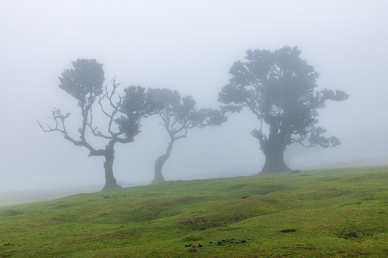
The Laurisilva of Madeira is a UNESCO World Heritage natural site (1999) and the largest surviving area of laurel forest — laurissilva — in the world, covering approximately 15,000 hectares across the northwestern highlands of Madeira island and representing roughly 90% of the total remaining laurissilva on the planet. This subtropical forest type was once widespread across southern Europe, the Mediterranean basin, and North Africa during the Pliocene epoch, between approximately 5 and 2 million years ago; when the climate cooled, it persisted only on the Macaronesian archipelagos — Madeira, the Azores, the Canary Islands, and Cape Verde — where oceanic conditions buffered against the temperature swings of the Ice Ages. It is a relict ecosystem of global scientific significance.
A Pliocene Forest Preserved by Ocean: The Ecology of the Laurisilva Northwestern highlands of Madeira, above 300 m elevation
The word laurissilva derives from the Latin laurus (laurel) and silva (forest), and describes a broad-leaved evergreen forest dominated by trees of the laurel family (Lauraceae) and their ecological associates. On Madeira, the laurissilva occupies the wetter, north-facing slopes and highland plateaux of the island above approximately 300 metres, where clouds and mist from the north Atlantic deliver persistent moisture throughout the year. The forest has no pronounced dry season: relative humidity inside the canopy remains above 80% for much of the year, and the moss, lichen, and fern communities that coat every surface — tree trunks, fallen logs, rock faces, the ground — reflect this perpetual dampness. The visual effect, particularly in the early morning when the clouds move through the canopy at eye level, is unlike any temperate European forest.
The dominant tree species are four members of the laurel and related families. Ocotea foetens, known locally as Til, is the largest and most architecturally impressive: it can reach 40 metres in height with a trunk circumference of several metres, and old specimens in areas such as Fanal and Ribeiro Frio develop spreading crowns and deeply furrowed bark encrusted with thick cushions of moss. Laurus novocanariensis, the Canarian Laurel (distinct from the common bay laurel of Mediterranean cooking, Laurus nobilis), is the most widespread species across a range of elevations. Persea indica, called Vinhatico, produces a valuable timber that was historically extracted from the forest. Apollonias barbujana, the Barbusano, grows on the drier south-facing margins of the laurissilva zone. These four species share the Lauraceae family or closely related families and represent the survivors of a much more diverse Pliocene flora that once stretched from the Iberian Peninsula to the Canaries across land that is now sea.
The scientific interest of the laurissilva is not only botanical. The forest contains an exceptional number of endemic animal species, many of which are found nowhere else on Earth. The Trocaz Pigeon (Columba trocaz), a large, pale-necked bird endemic to Madeira, is the forest’s most important animal disperser: it swallows the fruits of Til, Canarian Laurel, and other laurissilva species whole and deposits the seeds at new locations throughout the forest, making it ecologically indispensable for the forest’s regeneration. The pigeon was hunted almost to extinction in the early twentieth century and recovered only after legal protection was established. The Madeiran Firecrest (Regulus madeirensis), endemic to Madeira, and Zino’s Petrel (Pterodroma madeira), one of the world’s rarest seabirds with a breeding population of fewer than 100 pairs on Madeira’s central peaks, are also associated with the laurissilva habitat. The forest’s invertebrate fauna — particularly its endemic arthropods and molluscs — remains incompletely documented; new species continue to be described.
The forest floor is one of the most productive natural ecosystems in the Macaronesian region. A thick layer of decomposing leaf litter and moss acts as a sponge, absorbing rainfall and cloud condensation and releasing it slowly into the island’s groundwater system. This hydrological function is the reason Madeira’s laurissilva was protected by Portuguese law long before the UNESCO inscription: the forest was recognised as the source of the water that feeds the island’s levada irrigation network and the domestic water supply of Funchal. Deforestation in the laurissilva zone would rapidly reduce the water yield of the island’s northern watersheds — a consequence understood by Madeiran administrators as early as the 18th century.
The Levadas: 400 Years of Water Engineering Through the Forest Funchal — 30 km southeast; Santana — 15 km northeast of Ribeiro Frio
Madeira island is divided hydrologically in an almost absolute way by its central mountain ridge. The north-facing slopes receive abundant rainfall from the north Atlantic; the south-facing slopes, where the capital Funchal is located and where most of the island’s agriculture and population are concentrated, are significantly drier. This imbalance was the problem that the levada system was built to solve. A levada is a narrow irrigation channel, typically 30-60 centimetres wide and constructed in stone or, in later periods, concrete, that carries water from the wet northern valleys across or around the island’s ridges to the drier southern agricultural zones. Construction of the levada network began in the 15th century, shortly after Portuguese settlement of the island, and continued intermittently for four centuries; the total length of the network is approximately 2,200 kilometres.
The most remarkable sections of the levada system pass directly through the laurissilva. Engineers in the 15th through 19th centuries cut channels into the rock faces above the forest, following the contour lines of the terrain at a near-constant gradient — typically less than one metre of descent per kilometre — so that the water flows continuously without pumping. The levadas are maintained by levadeiros, workers employed by the regional water authority to clear blockages, repair cracks, and manage the flow distribution among the farmers who draw from each channel. The levadeiro tradition is several centuries old and the knowledge required — understanding flow rates, seasonal variation, and the maintenance needs of specific channels — was historically transmitted within families.
The walking paths that follow the levadas along their contour courses through the laurissilva have become Madeira’s primary tourist infrastructure. Because the channels must remain accessible for maintenance, a footpath typically runs alongside each levada for its entire length. These paths, cut into cliff faces and passing through tunnels bored through ridges, provide access to the interior of the laurissilva that would otherwise be impassable terrain. The most celebrated levada walks include the Levada das 25 Fontes (25 Springs), which passes through dense laurissilva to a waterfall in a glacial cirque above Rabaçal; the Levada do Caldeirao Verde in the Santana area, which ends at a series of waterfalls beneath a basalt amphitheatre; and the Levada do Rei (King’s Levada), which passes through a section of laurissilva containing some of the largest surviving Til trees on the island. The paths at Fanal, on the high plateau above Porto Moniz, pass through parkland-like open laurissilva where centuries-old Til trees stand in grassland, their canopies draped with lichen and moss.
The altitude of the laurissilva zone and the persistent cloud cover mean that conditions can change rapidly. Temperatures on the northern slopes above 600 metres are significantly lower than in Funchal — typically 10-15 degrees Celsius cooler — and mist or rain can reduce visibility on the levada paths to a few metres. The paths themselves, while not technically demanding, are narrow, often without barriers above steep drops, and can be slippery in wet conditions. Appropriate footwear and clothing are essential.
Practical information
The Laurisilva of Madeira is accessible from Funchal, the island’s capital, by hired car, taxi, or organised tour. There is no public transport to most of the laurissilva access points. The main entry points are Ribeiro Frio (approximately 30 km northeast of Funchal via the ER103 road; a forest park with a trout hatchery and easy short walks), Fanal (a high plateau above Porto Moniz, approximately 45 km northwest of Funchal; accessible only by car on mountain roads and closed by fog or ice in winter), and Rabaçal (above Calheta; the starting point for the Levada das 25 Fontes and Levada do Risco walks; reached by a restricted road where a shuttle bus operates in summer).
The Parque Natural da Madeira administers the UNESCO site. Entry to the forest itself is free; the Ribeiro Frio visitor centre has information on trails and wildlife. Guided levada walks are offered by numerous operators in Funchal. The Fanal plateau is best visited in spring (March-May) when the Til trees flower and the forest is at its most active, or in October-November for autumn colours in the understorey. Summer can bring heavy visitor numbers on the most popular levada routes.
There are no other UNESCO World Heritage Sites on Madeira island; the nearest UNESCO sites are on the Portuguese mainland, over 1,000 kilometres away.
Frequently Asked Questions
What is laurissilva and why is it a relict ecosystem?
Laurissilva (or laurisilva) is a subtropical broad-leaved evergreen forest dominated by trees of the laurel family (Lauraceae) and their ecological associates. During the Pliocene epoch, between approximately 5 and 2 million years ago, this forest type covered large areas of southern Europe, the Mediterranean coastline, and North Africa — a vast continuous belt of warm, humid, evergreen woodland that extended from the Iberian Peninsula east to the Caucasus and south to the Sahara before that region became arid. When the climate began cooling at the end of the Pliocene and into the Pleistocene Ice Ages, temperatures dropped, rainfall patterns changed, and the Mediterranean basin became seasonally dry. The laurissilva died back across most of its former range, retreating to refugia where oceanic conditions continued to provide the warmth and humidity it required. The Macaronesian islands — Madeira, the Azores, the Canary Islands, and Cape Verde, all located in the north Atlantic where the ocean moderates temperature extremes — proved to be the most durable of these refugia. A relict ecosystem is one that persists in a reduced range after the broader conditions that once sustained it have changed; it represents a living fragment of a biome that no longer exists in its original form and extent. The laurissilva on Madeira is therefore not simply a forest: it is a biological archive of the vegetation that covered much of southern Europe before the Ice Ages reshaped the continent’s ecology.
Which levada walks pass through the best sections of the UNESCO laurissilva?
Several levada walks give direct access to the UNESCO-listed laurissilva, and the choice depends on the experience level and time available. The Levada das 25 Fontes near Rabaçal is one of the most accessible: from the Rabaçal rest house the path descends through dense laurissilva to a waterfall area fed by twenty-five springs emerging from the basalt rock; the return walk is approximately 10 km and takes 3-4 hours. The Levada do Caldeirao Verde, beginning near Queimadas above Santana, passes through some of the most pristine remaining laurissilva on the island’s north coast — here the Til and Canarian Laurel trees reach their full stature and the canopy closes overhead; the round trip is approximately 12 km. The Levada do Rei near São Jorge offers access to a section of old-growth laurissilva with exceptionally large Til specimens. At Fanal, there are no levada paths as such, but the high plateau above Porto Moniz provides open views across ancient Til trees that grow in parkland conditions, their trunks and branches entirely encrusted with moss and lichen; this is the most photographed area of the laurissilva and is best reached in morning light before the clouds build. For those with limited mobility, the area around Ribeiro Frio above Funchal has short, well-maintained paths through genuine laurissilva accessible from a car park.
What endemic birds can be seen in the Laurisilva of Madeira, and when is the best time to spot them?
The laurissilva is home to three bird species of particular conservation interest. The Trocaz Pigeon (Columba trocaz) is endemic to Madeira and is the forest’s key seed disperser; it feeds on the fruits of laurissilva trees — particularly the berries of Til and Canarian Laurel — and deposits the seeds throughout the forest, making it ecologically central to the forest’s long-term regeneration. The pigeon was heavily hunted in the early twentieth century and came close to extinction; it recovered after legal protection was introduced and is now relatively common in the laurissilva, particularly in the Ribeiro Frio and Fanal areas. It is a large bird, noticeably bigger than the familiar feral pigeon, with a pale grey neck patch. The Madeiran Firecrest (Regulus madeirensis) is an endemic subspecies recently elevated to full species status; it is Europe’s smallest bird and inhabits the laurissilva from mid-elevation to the tree line, moving through the canopy in small groups that are often located by their high-pitched calls before being seen. The best time to see both species is from March through June, when the birds are most vocal and active during breeding season. Zino’s Petrel (Pterodroma madeira), one of the world’s rarest seabirds with fewer than 100 breeding pairs, nests on Madeira’s central peaks above the laurissilva zone and can occasionally be seen flying over the forest at dusk during the breeding season (April to September).
,_Lorbeerwald_--_2025_--_1532.jpg)