The Prehistoric Rock Art Sites in the Côa Valley of northeastern Portugal constitute the largest known concentration of open-air Palaeolithic rock art in the world — approximately 1,200 engraved panels distributed along a 17-kilometre stretch of the Côa River, a tributary of the Douro. The engravings date from approximately 22,000 to 10,000 BCE and depict horses, aurochs, ibex, deer, and fish carved into outcrops of schist and greywacke bedrock. UNESCO inscribed the site in 1998; in 2010 the inscription was extended across the Spanish border to include Siega Verde in Salamanca province, creating a trans-boundary World Heritage property.
The Engravings: An Open-Air Gallery Carved Over 12,000 Years Côa Valley, northeastern Portugal, near Vila Nova de Foz Côa
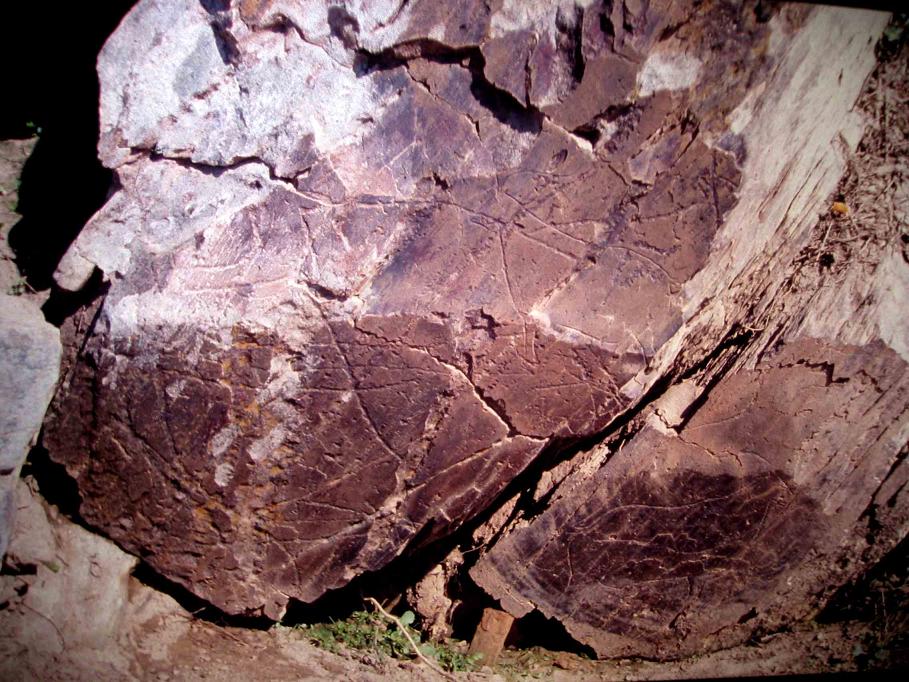
What distinguishes the Côa Valley from the most famous examples of Palaeolithic art — the painted caves of Lascaux, Altamira, and Chauvet — is its setting. The art here is not hidden in the darkness of underground galleries. It was made outdoors, on the vertical and near-vertical faces of river outcrops directly exposed to sky, weather, and the seasonal flooding of the Côa River. Approximately 1,200 individual panels have been documented across seventeen principal sites along the valley, with concentrations at Canada do Inferno, Penascosa, and Ribeira de Piscos. The substrate is schist and greywacke — both resistant metamorphic rocks that fracture in predictable ways, providing relatively smooth working surfaces for the Palaeolithic engravers who used flint tools to incise lines into the stone.
The images span the Upper Palaeolithic, from roughly 22,000 BCE through approximately 10,000 BCE — a period corresponding to the Gravettian, Solutrean, and Magdalenian cultural phases. The dominant subjects are large herbivores: horses appear most frequently, followed by aurochs (the wild ancestor of domestic cattle), ibex, and deer. Fish, identifiable as salmonids, appear at several sites — a detail consistent with the Côa River’s ecology both then and now. The engravers used a variety of techniques: fine incised lines producing delicate, detailed figures; deep percussion using a stone tool struck repeatedly; and a combination of both. Many panels carry multiple images superimposed over centuries or millennia, with figures of different periods and styles overlapping in ways that document successive phases of use.
The survival of open-air engravings for twenty millennia requires explanation. Cave art is protected by the stable temperature and humidity of underground environments; outdoor art is exposed to rain, frost, biological growth, and the mechanical stress of thermal expansion and contraction. At Côa, several factors combined to prevent significant deterioration. The schist is exceptionally hard and resistant to chemical weathering. The Côa Valley has a dry continental climate — the granite upland behind the valley blocks Atlantic moisture — so the engravings receive relatively little rainfall. The valley is also oriented in a way that reduces direct solar exposure on many of the carved panels. The result is that figures engraved twenty thousand years ago remain legible today with a clarity that astonishes specialists.
The trans-border extension of the inscription to include Siega Verde in 2010 added 94 engraved panels in Castilla y León, Spain, approximately 80 kilometres northeast of the Côa Valley across the border. Siega Verde, on the banks of the Águeda River (a tributary of the Douro), was documented in 1988 and shares the same open-air character, the same Upper Palaeolithic dating, and many of the same subjects as the Portuguese sites. The inclusion of Siega Verde created one of UNESCO’s few trans-national Palaeolithic art properties, recognising a shared cultural landscape that predates national borders by approximately twenty thousand years.
Discovery, the Campaign to Save the Valley, and the Archaeological Park Vila Nova de Foz Côa — 140 km east of Porto via A4/IP2
The story of how the Côa Valley came to be a UNESCO World Heritage Site is itself an important part of its history — a case study in how public mobilisation and scientific advocacy reversed a major infrastructure decision. In 1991 and 1992, the Portuguese electricity company EDP (Energias de Portugal) was advancing plans to construct the Foz Côa dam, which would have flooded the lower reaches of the Côa River valley and submerged the majority of the engraved panels beneath the new reservoir. During the engineering surveys that preceded construction, archaeologists contracted to assess the project area began finding engraved figures on the valley’s rock outcrops. The first findings were reported in internal documents in 1992; by 1993 the scope of the discovery — thousands of figures across dozens of sites — was becoming clear to specialists.
The government of the time, led by the Social Democrat Party, initially maintained that the dam would proceed and that the most important panels could be moved or documented before flooding. The archaeological establishment resisted this position, arguing that removing the engravings from their geological and landscape context would destroy their scientific value. In 1994 and 1995, the scale of international concern grew: UNESCO and ICOMOS (the International Council on Monuments and Sites) sent missions to assess the site and issued statements urging preservation. Portuguese archaeologists organised public exhibitions in Lisbon and Porto. International media coverage reached a broad public audience.
The critical turning point came with the Portuguese general election of October 1995. The incoming Socialist government under António Guterres suspended the dam project within weeks of taking office. In January 1996, the government formally cancelled the Foz Côa dam. Construction of the Côa Valley Archaeological Park began in the same year, and the park opened to visitors in 1996. The speed with which the Côa Valley received UNESCO inscription — 1998, just two years after the park opened — reflected the international significance that the campaign itself had established.
The Museu do Côa (Côa Museum) opened in 2010 in Vila Nova de Foz Côa, the nearest town to the main archaeological sites. The museum was designed by the Portuguese architects Camilo Rebelo and Tiago Pimentel, with a building embedded in the valley’s schist slopes that reflects the geological character of the landscape. The museum’s permanent collection covers Upper Palaeolithic art, the archaeology of the Côa Valley from prehistoric through historic periods, and the story of the discovery and the dam campaign. Site visits to the main rock art panels (Canada do Inferno, Penascosa, Ribeira de Piscos) are conducted by park guides in jeeps and on foot; advance booking is required.
Practical information
The Côa Valley Archaeological Park is headquartered in Vila Nova de Foz Côa, approximately 140 km east of Porto by road (A4 motorway to Régua, then IP2 south to Vila Nova de Foz Côa). There is no direct rail connection to Vila Nova de Foz Côa; visitors without a car should take the train to Pocinho (end of the Douro Line) and arrange onward transport. A taxi from Pocinho to Vila Nova de Foz Côa covers approximately 15 km.
Guided visits to the rock art sites are mandatory — the panels are not accessible independently. The park offers morning and afternoon tours to Canada do Inferno (the most accessible site, reached by jeep), Penascosa (a longer excursion on foot along the riverbank), and Ribeira de Piscos. Tours depart from the Museu do Côa and must be booked in advance, especially in July and August. The Museu do Côa is open Tuesday through Sunday; the rock art sites are closed on Mondays. The visit to Canada do Inferno is feasible in approximately three hours including the museum; a full day is recommended for those wishing to visit multiple sites.
The Alto Douro Wine Region lies 80 km to the west and can be combined with a visit to the Côa Valley in a two-day itinerary. The town of Pinhão in the Douro Valley is approximately one hour’s drive from Vila Nova de Foz Côa.
Frequently Asked Questions
Why is the Côa Valley rock art considered the world’s most important open-air Palaeolithic site?
The Côa Valley holds this distinction primarily because of scale. With approximately 1,200 documented engraved panels spread across seventeen principal sites along 17 kilometres of river valley, it is the largest concentration of open-air Palaeolithic art ever found anywhere in the world. Cave art assemblages such as Lascaux or Altamira contain hundreds of painted images within single underground spaces; the Côa Valley contains thousands of engraved figures distributed across an open landscape, created over a period spanning roughly twelve thousand years. The site’s scientific importance is further amplified by its open-air setting: studying how the images were positioned in relation to the landscape, the river, the light, and each other provides evidence about Palaeolithic spatial thinking and symbolic behaviour that is simply not available from cave art. The extended trans-border inscription that incorporated Siega Verde in 2010 reinforced this status by identifying a Palaeolithic artistic tradition that extended across what is now the Portuguese-Spanish border — a coherent cultural province of Upper Palaeolithic hunter-gatherers whose territory was defined by the Douro river system, not modern political geography.
How were the Côa Valley engravings discovered, and why was the dam project cancelled?
The engravings came to light during engineering surveys conducted between 1991 and 1993 in advance of construction of the Foz Côa hydroelectric dam, which EDP (Energias de Portugal) intended to build across the lower Côa River. Archaeologists brought in to assess the project area began documenting engraved figures on the valley’s rock faces. Early reports were initially treated as findings to be managed within the dam project’s environmental impact process rather than as grounds to reconsider the project. The situation changed when archaeologists, led by figures including João Zilhão and Mário Varela Gomes, made their findings public through academic publications and media appearances, and when international organisations including UNESCO and ICOMOS sent expert delegations and issued formal statements of concern. The Portuguese public engaged significantly: archaeological associations, artists, and civic groups mounted exhibitions and campaigns that kept the issue in the national media for more than a year. The dam project became a political issue in the 1995 election campaign. The incoming Socialist government of António Guterres cancelled the project in early 1996, citing both the archaeological value of the site and a re-evaluation of the dam’s economic case. The decision is widely cited in heritage policy literature as a significant example of successful campaigning for preventive archaeological conservation.
Can visitors see the rock art independently, or is a guide required?
A guided visit is mandatory for all visits to the rock art panels at the Côa Valley Archaeological Park. The panels are located in terrain that is difficult to navigate without local knowledge, and independent access to the sites is not permitted. Visits are organised by the park staff and depart from the Museu do Côa in Vila Nova de Foz Côa. The main sites open to visitors are Canada do Inferno (reached by jeep on a dirt track along the valley), Penascosa (a walking excursion along the riverbank, approximately 3 km), and Ribeira de Piscos (the most remote site, requiring advance arrangement). Tour groups are small — typically six to eight people maximum — to minimise disturbance to the sites. The guides are trained to point out specific panels and explain how to read the superimposed figures of different periods, which require some guidance to distinguish. Booking in advance is strongly recommended, particularly for July and August when the park operates at capacity. The park’s website (arte-coa.pt) handles reservations and lists tour schedules and prices. Photography is permitted but flash and tripods are restricted at certain panels.
Sources
- S1 — Aubry, Thierry. 200 séculos de história do Vale do Côa. IGESPAR, 2009. ISBN 978-989-8052-14-8.
- S2 — Bahn, Paul G. The Cambridge Illustrated History of Prehistoric Art. Cambridge University Press, 1998. ISBN 978-0-521-45473-5.
Spotted an error? Write to editorial@culturalheritageonline.com and we correct it the same day.