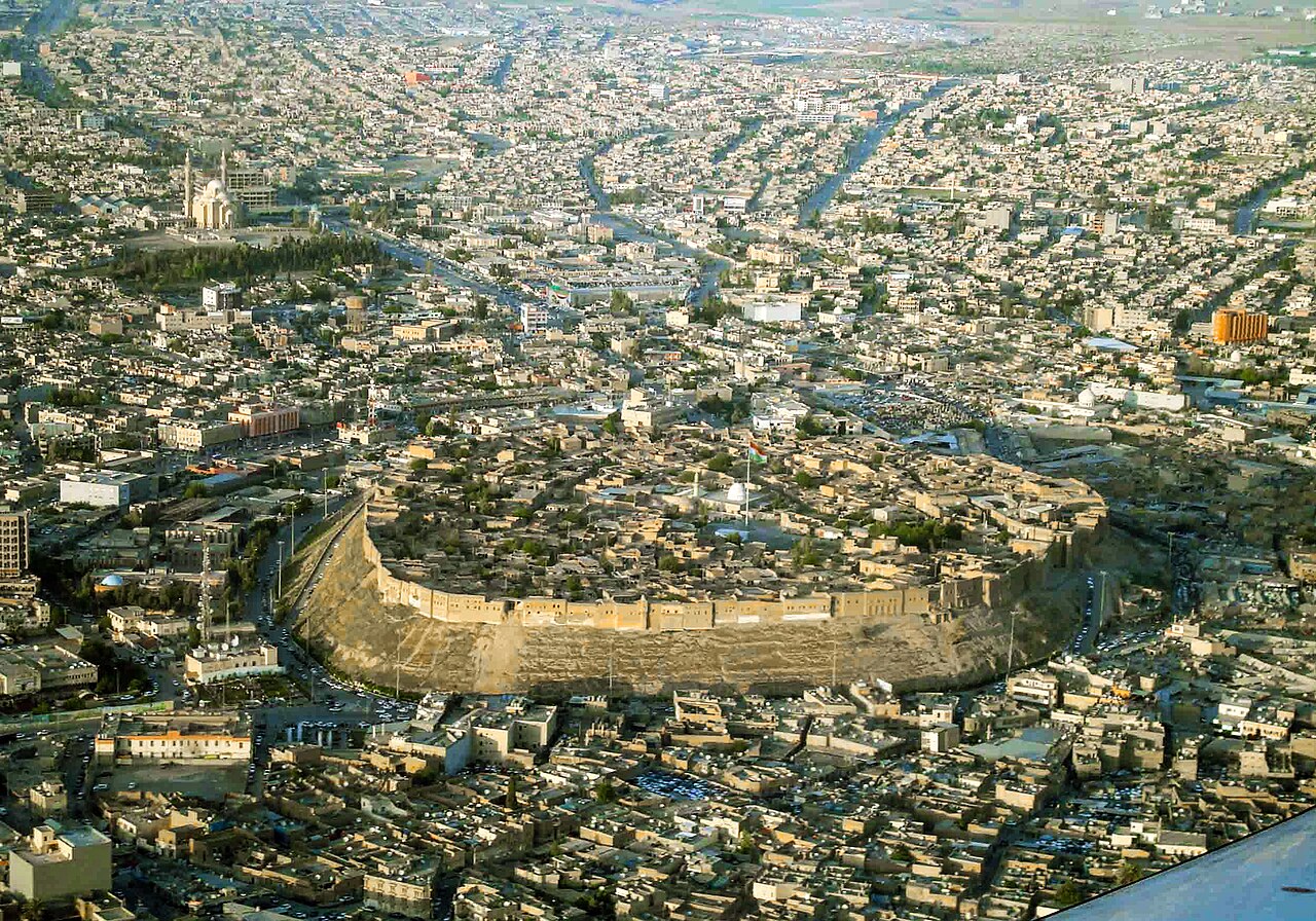
The Citadel of Erbil rises 25 to 32 metres above the modern city of Erbil on an oval tell — an archaeological mound of compressed human debris — whose accumulated layers of occupation may represent between 6,000 and 8,000 years of continuous habitation, making it a serious candidate for the oldest continuously inhabited settlement on Earth. UNESCO inscribed it in 2014. The citadel sits at the centre of Erbil (Hawler in Kurdish), capital of the Kurdistan Region of Iraq, and is surrounded on all sides by the active bazaar and textile markets of one of the Middle East’s fastest-growing cities.
The Tell: 8,000 Years of Occupation in Thirty Metres of Mud Brick Iraqi Kurdistan · Erbil Governorate
A tell is the result of repeated cycles of construction, collapse, and rebuilding on the same site. Each generation of structures, when abandoned or destroyed, becomes the foundation for the next, and over millennia the accumulated debris raises the ground level substantially above the surrounding plain. The Erbil tell is an unusually coherent example of this process: its oval plan, roughly 430 metres at its longest axis and covering approximately 102,000 square metres, has remained recognisably intact across thousands of years because the site’s elevated position and the defensibility that elevation conferred made it continuously worth rebuilding rather than abandoning.
The earliest confirmed evidence of occupation on the tell dates to the Chalcolithic period, roughly 6,000 years ago, though some scholars have argued for earlier occupation reaching back to 8,000 years. The site appears in Assyrian textual sources as Arba’ilu, a place name meaning “four gods” in Akkadian, and it functioned as an administrative and religious centre within the Assyrian Empire during the first and second millennia BCE. The Assyrian Empire’s heartland lay along the Tigris River to the south and west, and Erbil sat on trade routes connecting Mesopotamia to the Kurdish mountains and to Anatolia beyond.
The visible fabric of the citadel today is overwhelmingly from the 17th to 19th centuries CE. The current arrangement of courtyard houses, narrow lanes, and public buildings reflects the Ottoman period and the subsequent decades of the 19th century, during which the citadel functioned as a densely inhabited residential neighbourhood with a population that at its peak in the early 20th century may have reached several thousand. In 2007, the Kurdish Regional Government (KRG) undertook a controversial decision to relocate all but one family from the citadel — the relocation of one household was retained as a symbolic gesture to maintain the legal status of continuous habitation — in order to begin a comprehensive restoration programme supported by UNESCO and a range of international partners.
The restoration work has been extensive. The Textile Museum, which opened within the citadel, documents the weaving traditions of the Kurdistan Region; the Hammam Museum occupies a restored bathhouse structure; and the Loom House demonstrates traditional weaving techniques in an active setting. Archaeological investigations conducted during the restoration have begun to reveal the depth of buried occupation below the Ottoman-era structures, though the logistical and ethical complexity of excavating a still-inhabited and heavily built-over tell has kept the systematic archaeology fragmentary. The citadel’s inscription on the UNESCO World Heritage List in 2014 was partly intended to catalyse and protect ongoing research and restoration work.
The Bazaar, the Mudhafaria Minaret and the City Below Erbil · Kurdistan Region of Iraq
The citadel does not stand in isolation. Its immediate surroundings are as much a part of the visitor experience as the tell itself, and understanding the relationship between the elevated fortification and the bazaar that grew at its base is essential to reading the site correctly. The covered markets below the citadel’s south face — particularly the textile bazaar — are active commercial spaces that have operated continuously for centuries. The warren of stalls selling fabrics, spices, metalwork, and household goods is not a heritage reconstruction but a functioning economy, and the citadel’s visual dominance over this market is the defining urban relationship of central Erbil.
Immediately below the southern face of the citadel, in Minare Park, stands the Mudhafaria Minaret: a 12th-century brick tower that is one of the very few surviving above-ground structures in Erbil from the pre-Ottoman period. The minaret dates to the Zengid dynasty, which controlled much of northern Mesopotamia in the 12th and 13th centuries CE, and its decorative brickwork — intricate geometric patterns achieved through the careful arrangement of standard rectangular bricks — is characteristic of the Seljuk-influenced architectural tradition of the period. The mosque that the minaret originally served is long gone, and the minaret now stands in the park as an isolated monument, its height and proportions making clear why it survived when lower and less conspicuous structures did not.
Erbil itself is a rapidly developing city with a population that has grown substantially since the relative stabilisation of the Kurdistan Region following the 1991 Gulf War and more dramatically since 2003. The city’s prosperity — built substantially on oil revenues and a significant construction and real estate sector — has produced a modern urban sprawl around the ancient core, with shopping malls, international hotels, and infrastructure projects that exist in striking visual contrast to the tell and the bazaar. For visitors, this contrast is itself informative: the citadel’s survival and its current restoration are taking place within a specific political and economic context that shapes what gets preserved, how, and for whom.
The broader Erbil region contains a number of additional sites of historical interest, including the ruins of Nimrud (ancient Kalhu), an Assyrian capital approximately 90 kilometres to the southwest, and the Mar Mattai Monastery, a Christian foundation of the 4th century CE in the mountains northwest of the city. Access to some sites in the wider region requires attention to current security conditions; the Kurdistan Region is significantly safer than the rest of Iraq for tourists, but conditions change and up-to-date travel advisories should be consulted before any visit.
To the south, within Iraq but outside the Kurdistan Region, lie three additional UNESCO World Heritage Sites that form part of the dense archaeological landscape of ancient Mesopotamia. Ashur (Qal’at Sherqat), approximately 200 kilometres south of Erbil, was the original capital of the Assyrian Empire and was inscribed in 2003; it is currently on the List of World Heritage in Danger. Hatra, a first-century CE Parthian city whose remarkable state of preservation before 2015 made it one of the most significant archaeological sites in the Middle East, lies approximately 350 kilometres south and is also In Danger following deliberate destruction by ISIL. Samarra Archaeological City, 400 kilometres south, contains the iconic spiral minaret of the Great Mosque and was inscribed in 2007.
Practical information
Erbil is served by Erbil International Airport, with direct flights from a number of European, Middle Eastern, and regional hubs. Visa arrangements for the Kurdistan Region of Iraq operate somewhat independently of the rest of Iraq; many nationalities can obtain a visa on arrival or an e-visa for the Kurdistan Region without requiring a full Iraqi visa. Requirements change, so checking current guidance from the Kurdistan Regional Government’s official sources before travel is essential.
The citadel is open to visitors during daylight hours. The museums within it have separate opening hours that should be confirmed locally, as they have varied during the restoration period. Entrance to the citadel itself has generally been free; individual museums may charge small fees. The bazaar below the citadel is most active in the mornings and early afternoons. Erbil has a wide range of accommodation, from international chain hotels to local establishments. The best time to visit is spring (March to May) or autumn (September to November); summers are extremely hot, with temperatures regularly exceeding 40°C. The city’s infrastructure for international tourism has improved substantially in recent years, and English is spoken in hotels and many tourist-facing businesses.
Frequently Asked Questions
Is it safe to visit Erbil and the Kurdistan Region of Iraq?
The Kurdistan Region of Iraq has maintained a substantially different security situation from the rest of the country for the past three decades. The region has its own security forces (the Peshmerga), its own government, and effective border controls that have kept it apart from the worst of the violence that affected central and southern Iraq after 2003 and during the ISIL period from 2014 to 2017. Erbil itself was not taken by ISIL, though the front lines of that conflict came within a relatively short distance of the city at the conflict’s peak in 2014. Since 2017, the security situation within the Kurdistan Region has been considerably more stable, and Erbil has received a growing number of international tourists. That said, the broader geopolitical context of Iraq remains complex, and travellers should consult current travel advisories from their governments before planning a visit. The UK Foreign, Commonwealth and Development Office and the US State Department both maintain up-to-date advisories specific to the Kurdistan Region. Most travellers who have visited in recent years report that Erbil feels safe and that visitor infrastructure is functional and hospitable. The risk profile is meaningfully different from a visit to Baghdad or the southern governorates.
What is a tell and why is the Erbil tell significant?
A tell (also spelled tel or tepe in different regional traditions) is an artificial mound formed by the accumulated debris of successive human settlements built on the same site. When a mud-brick structure is abandoned or collapses, it leaves a layer of compressed earth and debris. The next occupants build on top of this layer, raising the ground level incrementally. Over hundreds or thousands of years, this process can raise a site by tens of metres. The Erbil tell is significant for several reasons. First, its stratigraphic depth — the compressed record of occupation within the mound — potentially extends over 6,000 to 8,000 years, making it one of the deepest and most durable records of continuous urban habitation known. Second, its oval plan has remained coherent across this entire period, suggesting that the same defensible hilltop position has been valued consistently across radically different political and cultural eras. Third, unlike many tells in the region, it has not been extensively excavated: the continuous habitation of the site prevented systematic archaeology, meaning that the buried stratigraphic record is relatively intact. The UNESCO inscription was partly motivated by the need to ensure that the restoration and development work now underway on the citadel is conducted in a way that preserves and documents rather than destroys this buried record.
What other Assyrian and Mesopotamian heritage sites can be visited from Erbil?
The landscape surrounding Erbil is extraordinarily rich in ancient Assyrian and Mesopotamian sites, though access to some of them requires attention to current security conditions. Within the Kurdistan Region itself, the site of ancient Nineveh (Kuyunjik mound) is located near Mosul, approximately 80 kilometres west of Erbil. Mosul was recaptured from ISIL in 2017 and reconstruction is ongoing, but the Nineveh ruins are accessible to visitors. The ancient Assyrian capitals of Nimrud (Kalhu) and Khorsabad (Dur-Sharrukin), both near Mosul, suffered deliberate ISIL destruction in 2015 but are also accessible and the surviving fabric, though diminished, remains significant. Ashur (Qal’at Sherqat), the original Assyrian capital and a UNESCO World Heritage Site inscribed in 2003, is approximately 200 kilometres south of Erbil. Access requires passing through checkpoints between the Kurdistan Region and the rest of Iraq; this is feasible but requires planning. Hatra, a Parthian city of the first century CE with remarkable colonnaded temples, is approximately 350 kilometres south and similarly accessible with advance planning. Both Ashur and Hatra are on UNESCO’s List of World Heritage in Danger as a consequence of armed conflict damage.