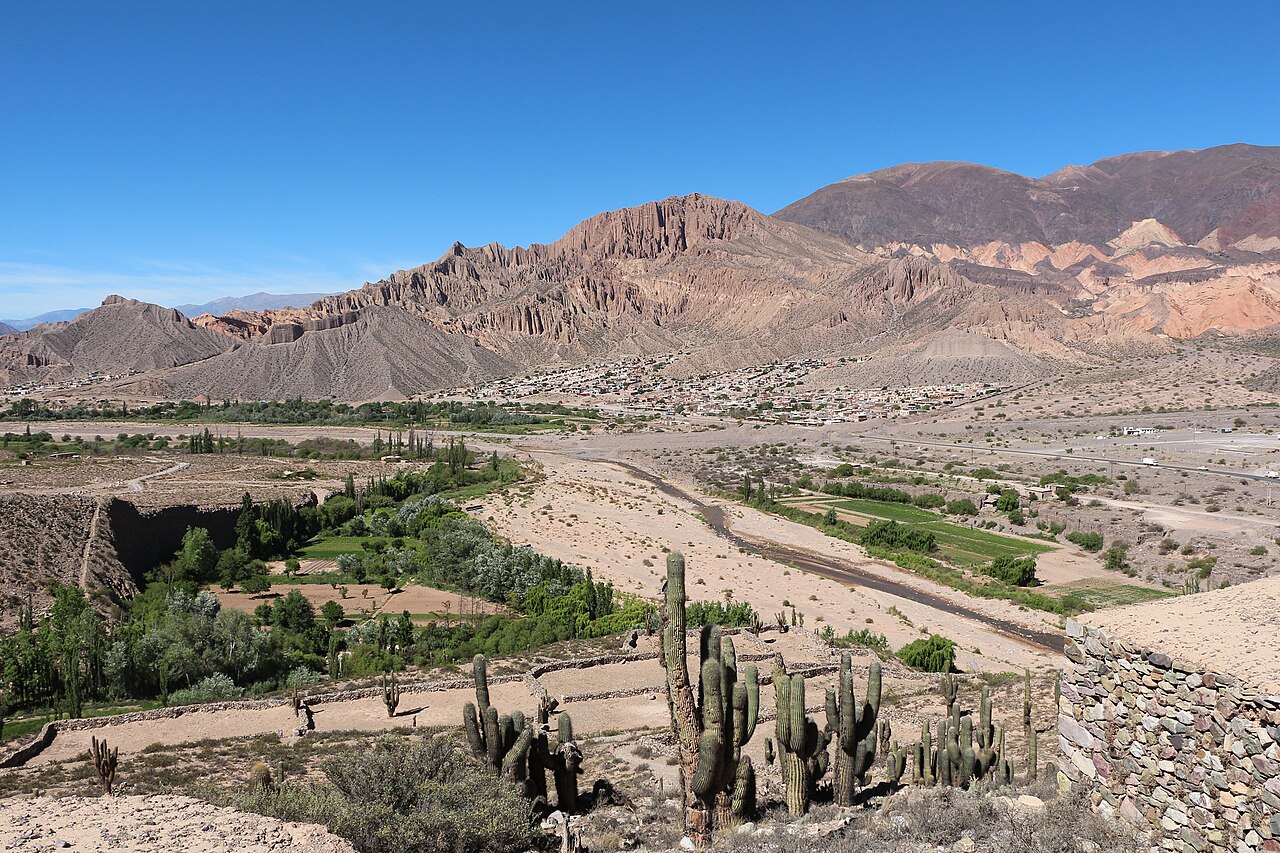
The Quebrada de Humahuaca is a 155-kilometre canyon carved by the Río Grande through the Andes of Jujuy Province in northwest Argentina, bearing evidence of continuous human settlement stretching back 10,000 years. UNESCO inscribed it as a mixed cultural and natural World Heritage Site in 2003, recognising the canyon not only for its extraordinary geology — including the minerally-striated Hill of Seven Colours — but for the layered record of pre-Columbian civilisations, Inca imperial roads, Spanish colonial architecture, and living Andean traditions that survives along its floor and slopes.
A Canyon as a Civilisational Corridor Northwest Argentina · Jujuy Province
The Quebrada de Humahuaca has never simply been a landscape. For ten millennia it functioned as one of the primary corridors linking the high Andean altiplano to the lowland regions of what is now northern Argentina, carrying people, goods, and ideas across an altitude range that shifts dramatically within a short horizontal distance. The canyon runs roughly north to south along the Río Grande, with walls reaching heights of several hundred metres in places and soils ranging from deep reds to oranges, purples, and greens depending on the mineral composition of each stratum.
The Omaguaca people were among the most significant pre-Columbian inhabitants of the quebrada, building hilltop fortifications called pucarás to control the routes through the canyon. The most extensively studied of these is the Pucará de Tilcara, a substantial complex of dry-stone structures on a hill above the town of Tilcara. Archaeological work begun in the early 20th century revealed storage rooms, ceremonial platforms, and residential quarters, and a partial reconstruction — controversial among some archaeologists for its interpretive choices — now allows visitors to walk through the layout. The Inca incorporated the Omaguaca and the quebrada into their empire in the 15th century, using the existing road networks and grafting them onto the broader Qhapaq Ñan, the Andean road system that itself received UNESCO inscription in 2014 as a separate transnational site.
Spanish colonisation arrived in the 16th century and superimposed a new architectural and religious layer without erasing what came before. The colonial church of Uquía, a small village north of Tilcara, contains one of the most singular collections of 17th-century religious painting in South America: the so-called “angel soldiers” (ángeles arcabuceros), a series of paintings depicting archangels dressed in period military uniforms and armed with arquebuses. This Cuzco School adaptation of European devotional iconography to Andean military imagery makes Uquía a destination that repays close attention far out of proportion to the village’s size.
The canyon’s UNESCO designation as a mixed site reflects UNESCO’s recognition that the cultural and natural values here cannot be cleanly separated. The Hill of Seven Colours (Cerro de los Siete Colores) near Purmamarca — the most photographed geological formation in the quebrada — is not merely scenic. The oxidisation states of different minerals in the Andean rock record hundreds of millions of years of tectonic and chemical history. The same geological forces that produced these colours also shaped the high-altitude passes, water sources, and microclimates that made human settlement possible and persistent across a hundred centuries.
Tilcara, Humahuaca and the Living Culture of the Canyon Jujuy Province · Route 9
Three towns serve as the primary bases for exploring the quebrada: Purmamarca at the southern entrance, Tilcara roughly in the middle, and Humahuaca near the northern end. Each has a distinct character, and each repays more time than a single-day circuit from San Salvador de Jujuy — the provincial capital 65 kilometres south of Purmamarca — would allow.
Purmamarca is the most visited of the three, largely because the Cerro de los Siete Colores is immediately behind the village and the circuit walk around it takes only about an hour and a half. The central plaza retains much of its colonial character, and the church of Santa Rosa de Lima (17th century) is among the better-preserved early colonial structures in the region. The town’s artisan market, concentrated around the plaza, sells weavings and ceramics that reflect continued local production traditions, though the tourist economy has also introduced purely commercial goods that have no connection to regional craft.
Tilcara, with a population of roughly 5,000, is the quebrada’s de facto cultural capital. Beyond the Pucará, the Museo Arqueológico Dr. Eduardo Casanova holds one of the most significant collections of pre-Columbian material from the northwest Argentine region, including ceramics, metal objects, and human remains. The museum’s scope makes it an essential stop before or after walking the Pucará itself. Tilcara is also where most independent travellers base themselves, given its range of accommodation and its central position on the canyon.
Humahuaca, at 2,940 metres above sea level, is the canyon’s largest town and the site of its most distinctive colonial monument: the cabildo, whose mechanical figure of San Francisco Solano emerges at noon each day. But Humahuaca is most famous for the Carnaval de Humahuaca, a weeks-long celebration that begins forty days before Easter and fuses pre-Columbian Andean ceremonial practices with Catholic calendar observances. The carnaval involves the ritual “burial” of a figure representing the spirit of carnaval at its close, a practice that predates the Spanish conquest and that has been maintained without interruption despite centuries of religious pressure. UNESCO’s inscription of the quebrada explicitly cited these living cultural traditions as part of the site’s Outstanding Universal Value.
Further north, the quebrada continues toward the Bolivian border at La Quiaca, passing through landscapes that grow progressively more austere as altitude increases. The Serranías del Hornocal, accessible by a steep road from Humahuaca, offers a viewpoint over a range of folded rock that rivals the Cerro de los Siete Colores in geological drama but receives a fraction of the visitors.
Practical information
The Quebrada de Humahuaca lies along National Route 9 (RN 9), which connects San Salvador de Jujuy to the Bolivian border. Regular bus services run the full length of the canyon from the Jujuy terminal, with stops at Purmamarca, Tilcara, and Humahuaca. Journey times are approximately one hour to Purmamarca, one and a half hours to Tilcara, and two and a half hours to Humahuaca from Jujuy. San Salvador de Jujuy is served by domestic flights from Buenos Aires (approximately two hours). Car hire from Jujuy gives more flexibility for reaching sites off the main road such as the Serranías del Hornocal and the Laguna de Pozuelos flamingo reserve to the northwest.
The best time to visit is the dry season from April to November. July and August bring cold nights (temperatures can drop below freezing at altitude) but clear skies. January to March is the rainy season; roads can become impassable and the quebrada’s characteristic colours are partially obscured by cloud. The Carnaval runs in February or March depending on the Easter calendar. Altitude sickness is a genuine concern: San Salvador de Jujuy sits at 1,260 metres, but Humahuaca is at 2,940 metres and acclimatisation time of at least one night at intermediate altitude is advisable. Entrance fees apply at the Pucará de Tilcara. Accommodation ranges from basic hostels to boutique hotels; Tilcara has the widest selection.
Frequently Asked Questions
How does the Quebrada de Humahuaca relate to the Inca road system?
The quebrada was a key corridor of the Qhapaq Ñan, the Inca road network that connected Cusco to the southernmost reaches of the Tawantinsuyu empire in what is now northern Argentina and Chile. The Inca did not build the road through the quebrada from scratch: they incorporated existing trade and ceremonial routes used by the Omaguaca and earlier cultures, reinforcing them and adding the administrative infrastructure — tambos (waystation facilities), storage depots, and relay runner posts — that made the Qhapaq Ñan function as an imperial logistics system. The UNESCO inscription of the Qhapaq Ñan in 2014 as a transnational serial site, shared between six countries, formally recognised these connections. Within the quebrada itself, stretches of original Inca paving survive in several locations, particularly on the hillsides above the main valley floor where modern road construction did not reach. The Pucará de Tilcara was among the hilltop sites that the Inca repurposed and reinforced as part of their administration of the region. The layering of pre-Inca Omaguaca construction beneath Inca adaptations, which archaeologists began documenting systematically in the early 20th century, makes the Pucará an unusually legible record of the transition between indigenous political orders in the century before Spanish contact.
What are the angel soldier paintings in Uquía and why are they significant?
The ángeles arcabuceros — angel soldiers — of Uquía are a series of 17th-century oil paintings in the church of San Francisco de Paula depicting archangels dressed in the dress uniforms and plumed hats of colonial Spanish military officers, and carrying arquebuses (early firearms) rather than the swords or trumpets of European iconographic convention. They are products of the Cuzco School, a regional tradition of Catholic devotional painting that developed in Cusco after the Spanish conquest and spread across the Andes. The school was characterised by its adaptation of European iconographic models to local Andean imagery, colour preferences, and symbolic systems. The arcabucero tradition specifically is thought to have developed as a way of representing divine military power in terms immediately legible to Andean communities who had experienced the arquebus as the defining weapon of conquest. The Uquía paintings are among the finest surviving examples, and the isolation of the village — which has no other obvious reason for a tourist visit — gives them an impact that a museum setting would diminish. The church itself is a typical small Andean colonial structure: whitewashed adobe walls, a single nave, a bell tower integrated into the facade. The paintings hang on the nave walls and are visible during regular opening hours; a small donation to the church caretaker is customary.
Are there other UNESCO World Heritage Sites accessible from the quebrada?
The Quebrada de Humahuaca is relatively isolated from Argentina’s other UNESCO sites by distance. The two most significant sites in the country’s Patagonian south — Los Glaciares National Park (inscribed 1981) and the Cueva de las Manos in Santa Cruz Province (inscribed 1999) — lie roughly 1,600 and 1,700 kilometres south respectively, making them long-haul extensions rather than day trips. Los Glaciares, centred on the Perito Moreno Glacier and the Fitz Roy massif, is Argentina’s most visited UNESCO site; the Cueva de las Manos, accessible from Perito Moreno town, contains stencilled handprints and hunting scenes dating back approximately 9,000 years. Within Jujuy Province, the Laguna de Pozuelos Biosphere Reserve (not a UNESCO World Heritage Site but a Ramsar wetland) lies about 80 kilometres northwest of Humahuaca and is the site of one of the largest flamingo breeding colonies in South America. The Bolivian border at La Quiaca, about 120 kilometres north of Humahuaca, puts Potosí (UNESCO inscribed 1987) and the Tiwanaku site (inscribed 2000) within reach of a multi-day extension into Bolivia.