The Matobo Hills, inscribed by UNESCO in 2003 as a mixed cultural and natural World Heritage Site, form a 3,100 square kilometre landscape of granite domes, balanced boulder formations, and more than 3,000 rock art sites south of Bulawayo in Zimbabwe. The same landscape shelters one of the world’s densest concentrations of white rhinoceros and contains the graves of both an Ndebele king and a British colonial architect — two figures who shaped southern African history from opposite directions.
San rock art and granite landscapes 35 km south of Bulawayo, Zimbabwe
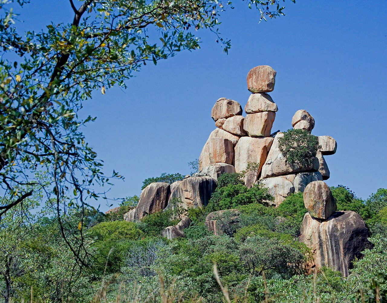
The name “Matobo” — also written “Matopos” — derives from the Sindebele word for “bald heads,” a direct reference to the smooth, rounded granite domes that define the skyline. These formations are the product of hundreds of millions of years of geological process: a vast granite batholith intruded into the older metamorphic rock, then progressively exposed by erosion. As the overlying rock was stripped away, the granite contracted and fractured along natural joint planes, producing the spherical boulders and exfoliated sheets that now balance in formations that appear structurally impossible but are geologically stable.
The most photographed of these formations — commonly called “Mother and Child” — shows a large rounded boulder supporting a smaller one, the two in contact over an area that seems insufficient to prevent collapse. These balancing rock formations are now the national symbol of Zimbabwe, appearing on the country’s coat of arms, banknotes, and official emblems. Their association with the nation’s identity predates independence: the rocks were equally prominent as symbols in the territory known as Rhodesia, demonstrating how potently a landscape feature can outlast the political entities that claim it.
The rock art record at Matobo spans roughly 13,000 years, from the Late Stone Age to the nineteenth century. The paintings were made by San people — also known as Bushmen — who occupied southern Africa as its original inhabitants long before the arrival of Bantu-speaking agricultural communities. Over 3,000 painted sites have been recorded in the Matobo Hills; the Inanke and Nswatugi caves contain some of the finest surviving examples. At Nswatugi, large-scale paintings of kudu, zebra, eland, and human figures in elaborate ceremonial headdresses extend across a curved shelter roof in a frieze that researchers have interpreted not as simple hunting records but as maps of altered states of consciousness — painted by ritual specialists during trance ceremonies in which the boundaries between the human and spirit worlds were believed to dissolve. The eland appears repeatedly across Matobo and across San rock art more broadly; in San cosmology, the eland is the most sacred animal, associated with potency, death, and transformation. Its prominent presence in hunting scenes reflects spiritual significance rather than dietary preference.
The vleis — flat, seasonally flooded grassland areas between the granite outcrops — provide grazing habitat for large mammals and are essential to the ecology of the hills. Matobo National Park, which covers the southern portion of the UNESCO-inscribed area, protects one of the highest densities of white rhinoceros (Ceratotherium simum) in the world. Conservation efforts in the park have been critical to the species’ survival in Zimbabwe. Leopard, sable antelope, and Verreaux’s black eagle (which nests on the granite cliff faces) are among the other species regularly observed.
Cecil Rhodes, Mzilikazi, and the complexity of heritage 35 km south of Bulawayo, Zimbabwe
Matobo Hills is one of the most morally complex UNESCO World Heritage Sites in Africa. The landscape contains the graves of two men whose historical legacies could not be more different: Mzilikazi, founder of the Ndebele kingdom, and Cecil John Rhodes, architect of British colonial expansion across southern Africa.
Mzilikazi kaMashobane was a military commander under the Zulu king Shaka who broke away in the 1820s and led his people — the Matabele, or Ndebele — northward through what is now South Africa and into Zimbabwe, where he established a new kingdom with Bulawayo as its capital. He died in 1868 and was buried at Entumbane hill in the Matobo Hills, following Ndebele tradition that associated the hills with ancestral spirits. The Ndebele name for World’s View — the summit where Cecil Rhodes is buried — is Malindidzimu: “place of benevolent spirits.” The name predates Rhodes’ arrival and reflects the hills’ deep significance in Ndebele spiritual geography.
Rhodes visited the Matobo Hills shortly before his death and expressed a wish to be buried at the summit of World’s View. He died in Cape Town in March 1902, and his body was transported by train through southern Africa to Bulawayo — a journey that required the active cooperation of Ndebele chiefs, some of whom had fought against his British South Africa Company in the Matabele Wars of 1893 and 1896. He was buried at World’s View alongside Leander Starr Jameson (his closest political associate) and a memorial to the Shangani Patrol, a British scouting force wiped out during the 1893 Matabele War. Both Mzilikazi’s burial place and Rhodes’ grave are UNESCO-listed heritage elements within the same inscribed property.
The presence of Rhodes’ grave in a UNESCO-listed landscape has generated sustained debate, particularly since the Rhodes Must Fall movement began in 2015 in Cape Town. Critics argue that honoring Rhodes within a World Heritage Site legitimizes a man whose policies of racial segregation and violent dispossession laid the groundwork for both apartheid and the destruction of African kingdoms. Defenders point to the grave’s unquestionable historical significance and the complexity of disentangling conservation from commemoration. Zimbabwe itself has navigated the question without formal resolution: the grave remains, the national symbol draws from the same landscape, and the hills hold both legacies simultaneously — a fact that the UNESCO mixed cultural-natural designation, created to recognize landscapes where human and natural values are inseparable, turns out to frame with unexpected accuracy.
Practical information
The Matobo Hills are located approximately 35 kilometres south of Bulawayo, Zimbabwe’s second city, reachable by car in under an hour on tarred road. Bulawayo has an international airport with connections to Johannesburg, Harare, and Victoria Falls; most visitors to Matobo arrive via Bulawayo. Day trips from Bulawayo are feasible, but accommodation is available within and near the park — including camps inside the national park. Entrance fees for Matobo National Park are payable in US dollars (Zimbabwe uses the US dollar as its primary currency for tourism transactions); confirm current fee levels through Zimbabwe Parks and Wildlife Management Authority. Guided tours to the principal rock art sites — Nswatugi, Inanke, and White Rhino Cave — are required for the rock art caves and strongly recommended for rhino tracking. The rhino tracking experience in Matobo is widely regarded as one of the most accessible in southern Africa, with guided walks on foot approaching white rhino at distances that would be impossible in a vehicle. Bring sun protection and adequate water. The best wildlife viewing is during the dry season (April to October); the wet season (November to March) brings green vegetation that can obscure rock art panels and makes some tracks impassable.
Frequently Asked Questions
Why are the Matobo Hills inscribed as a “mixed” UNESCO World Heritage Site?
UNESCO’s mixed designation applies to sites that meet Outstanding Universal Value criteria in both the cultural and natural categories simultaneously — a relatively rare classification. The Matobo Hills qualify on both grounds independently. On the cultural side, the landscape contains over 3,000 rock art sites spanning approximately 13,000 years, representing one of the densest and most significant concentrations of San paintings in the world. The archaeological evidence embedded in this art record documents the beliefs, ecological knowledge, and ritual life of southern Africa’s earliest inhabitants across an unbroken span from the Late Stone Age to the historical period. On the natural side, the Matobo Hills contain exceptional biodiversity anchored by one of the highest concentrations of white rhinoceros in southern Africa, as well as healthy populations of leopard, sable antelope, and Verreaux’s eagle. The granite landscape itself — its kopjes, domes, vleis, and the distinctive balancing rock formations — represents a geomorphological feature of global significance. The mixed designation reflects the UNESCO committee’s recognition that the cultural and natural values at Matobo are not separable: San rock art survives in part because the landscape’s topographic complexity made permanent agricultural settlement difficult, and the ecological character of the hills is itself shaped by the interaction of people and environment over millennia.
What do the San rock art paintings at Matobo actually depict, and how should they be interpreted?
The San paintings at Matobo depict animals — eland, kudu, zebra, giraffe — human figures in various states of movement and transformation, and complex geometric forms including grids, nested curves, and entoptic patterns (abstract shapes generated by the human nervous system during altered states). Early European interpretations treated the animal images as simple hunting records or magical aids to attract game. Contemporary scholarship, developed primarily by rock art researchers working with ethnographic accounts from San communities in the Kalahari, understands the paintings as records of shamanic ritual — specifically, of healing dances in which ritual specialists (shamans) entered trance states, experienced visions, and journeyed to the spirit world. Animals feature prominently because the San understood certain species — the eland above all, but also elephants and felines — as potent carriers of spiritual energy that could be accessed and redirected during trance. The transformation figures at Matobo, showing human bodies taking on animal characteristics (hooved feet, antelope heads), illustrate the shamanic experience of shape-shifting during visionary states. This interpretation is supported by the recurrence of the same imagery across thousands of geographically dispersed sites, suggesting a coherent symbolic vocabulary shared across the San cultural sphere over many millennia.
Is it safe to visit Matobo Hills, and how does the wider Zimbabwe security situation affect access?
Matobo Hills and the surrounding Bulawayo region have historically been among the safer areas of Zimbabwe for international visitors. The national park infrastructure is functional, rhino tracking guides are experienced, and the main rock art sites are accessible without significant logistical difficulty. Zimbabwe has experienced political and economic instability at various periods since 2000, and travel advisories from major Western governments typically recommend elevated caution for the country as a whole — but Matobo specifically has not been a site of political violence or significant crime targeting tourists. The practical challenges for visitors are more prosaic: the Zimbabwean dollar’s instability means that tourism transactions are effectively conducted in US dollars, ATM access outside Bulawayo is unreliable, and some park facilities reflect underinvestment. Visitors should carry sufficient US dollars in cash for park fees, guides, and accommodation. Health precautions standard for sub-Saharan Africa — malaria prophylaxis, traveller’s insurance including emergency evacuation — apply. Check current travel advisories from your own government before booking, and consider booking accommodation and guided park access through a reputable Bulawayo-based operator who can confirm current conditions on the ground.