
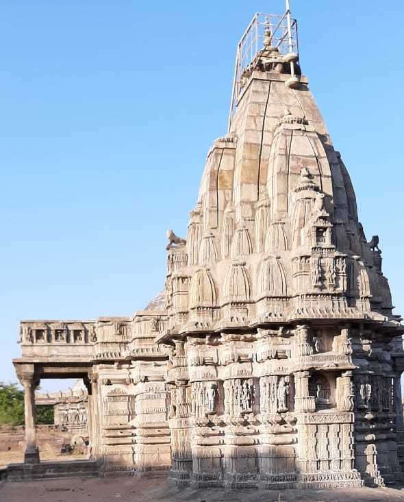
Champaner-Pavagadh Archaeological Park holds two exceptional places in a single inscribed zone: an extinct volcanic hill covered in Hindu and Jain shrines that have drawn pilgrims since the 8th century, and the best-preserved planned city from Gujarat’s pre-Mughal sultanate period — abandoned since 1535 CE and never reoccupied, leaving its 16th-century street plan and mosques essentially intact. UNESCO inscribed the combined site in 2004.
Pavagadh Hill: 900 Metres of Sacred Topography Gujarat, 47 km from Vadodara — cable car or 4,000 stone steps
Pavagadh is an extinct volcanic plug rising to 900 metres above the surrounding plain of eastern Gujarat. The hill’s distinctive profile — an abrupt vertical mass visible from the flatlands for 30 kilometres — made it a sacred landmark long before Champaner was built at its base. The earliest documented structures on the hill date from the 8th century CE, when Jain and Hindu communities began constructing shrines on the lower slopes and forested terraces. By the 12th and 13th centuries, Pavagadh had become an established pilgrimage circuit of considerable regional importance, its temples serving communities from across western India.
The Kalika Mata Temple at the summit is the reason the hill still draws pilgrims in large numbers. Dedicated to a form of the goddess Kali, it sits at the highest accessible point of the volcanic mass and is reached either by cable car (installed in recent decades) or by climbing approximately 4,000 cut stone steps through the forested terraces below. The original temple structure dates from the 10th to 11th centuries CE; the upper section was modified in the 16th century when Champaner’s Sultanate rulers installed a small mosque alongside the Hindu shrine — an arrangement that has persisted, with the mosque and the temple sharing the summit space in a form of coexistence unusual in the subcontinent’s architectural history. The current pilgrimage traffic is substantial: the Navratri festival in October draws hundreds of thousands of devotees over nine days.
Below the summit, the hill’s terraces preserve a sequence of Jain temples from the 11th to 14th centuries, carved in the white marble and dark stone typical of the Chalukya-period temple tradition of Gujarat. Several of these temples are partially ruined; others remain in active worship. The forested slopes between the temple clusters contain rock-cut water cisterns and the remains of defensive walls from the hill fort that protected Pavagadh before Champaner’s construction. The fort was considered militarily impregnable until 1484 CE, when Mahmud Begada, Sultan of Gujarat, took twenty-three months to capture it — one of the most sustained siege operations in medieval Indian history. His subsequent decision to build his new capital at the foot of the hill was a direct consequence of that military investment.
Champaner: The Perfectly Preserved Sultanate City At the base of Pavagadh — largely unexcavated, minimal visitor infrastructure
Champaner was designed and built as a complete planned city by Mahmud Begada, Sultan of Gujarat, following his capture of Pavagadh in 1484 CE. He renamed the site Muhammadabad and spent the next decades constructing a capital on a formal grid plan with separate residential, commercial and ceremonial zones — a city organisation reflecting both Islamic urban planning principles and local Gujarati building traditions. The Jama Masjid of Champaner, completed in 1523 CE, is the architectural centrepiece of this project and one of the finest mosques in India.
The Jama Masjid is a synthesis that would have been impossible anywhere else at that moment. Its plan — 172 pillars supporting five large and 172 smaller domes across a vast prayer hall — follows the hypostyle mosque tradition of the Islamic world. But the carving on those pillars, the bracketed corbels at the column capitals, the geometric stone lattice screens (jaalis) in the side walls, and the miniature tower-like minarets flanking the central dome draw directly from the Solanki-period Hindu and Jain temple tradition of Gujarat, adapted by craftsmen who had been building temples before the Sultanate’s arrival and continued their formal vocabulary within the new patron’s programme. The result is not hybrid in a compromised sense: it is a fully resolved architectural language, neither purely Islamic nor purely Hindu-Jain, that is specific to this city at this moment in history.
Champaner contains several other mosques of the same synthesis: the Kevda Masjid, the Nagina Masjid, the Lila Gumbaj ki Masjid, each varying the proportions and ornamental register. The city also preserves step-wells (vav), fortification walls, and the ruins of the palace quarter. The extraordinary condition of the site results from its abandonment: when the Mughal emperor Humayun captured Champaner in 1535 CE, he deported the court to Ahmedabad and the city was simply left. No subsequent population expanded, rebuilt or modernised it. It has been slowly reclaimed by vegetation, but the basic structure of Mahmud Begada’s planned capital is still legible in the landscape. Most of the site remains unexcavated; what is visible represents a small fraction of what the 52-square-kilometre inscribed zone contains.
The Archaeological Survey of India manages the principal monuments within the inscribed zone. The Jama Masjid interior is accessible to visitors and remains structurally sound; the forest around the other mosque clusters is being progressively cleared to allow study and access. The combination of the sacred hill and the abandoned sultanate city makes Champaner-Pavagadh one of the most archaeologically rich and least touristically developed UNESCO sites in India.
Practical information
Champaner-Pavagadh is 47 kilometres from Vadodara (Baroda), which is the standard approach. Vadodara has direct rail connections to Ahmedabad (90 minutes), Mumbai (approximately four hours), and Delhi (approximately twelve hours on express services), and an airport with domestic connections. From Vadodara, frequent buses and shared taxis cover the 47 kilometres to Champaner in roughly one hour. Local autorickshaws connect the bus stand to the archaeological zone entrance and to the Pavagadh cable car base.
The cable car to the Kalika Mata Temple summit operates daily except during heavy maintenance periods; the stone step route is always open and takes 2–3 hours of moderate climbing. The Archaeological Survey of India charges a standard entry fee for the Champaner monument zone; the cable car has a separate fare. The best season is October to February: the post-monsoon months are particularly striking, with the hill’s vegetation at its lushest and temperatures comfortable for hill climbing (18–28°C). March to May is hot and dry on the plain, though the hill remains somewhat cooler. Monsoon (June to September) makes the steps slippery and some paths in the monument zone muddy. Allow a full day to cover both the hill temples and the main Champaner mosques; two days allows more thorough exploration. Drinking water should be carried, especially for the hill ascent.
Frequently Asked Questions
Why is the Champaner-Pavagadh Archaeological Park significant enough for UNESCO inscription?
The site was inscribed in 2004 under criteria (iii), (iv) and (v), recognising its exceptional concentration of 239 monuments within a 52 square kilometre area, and specifically the extraordinary quality of the pre-Mughal Sultanate architecture at Champaner. The UNESCO evaluation noted that Champaner represents the only complete, unmodified example of a pre-Mughal city of the Gujarat Sultanate period anywhere in India — a city planned and built in a single generation (from 1484 to the 1530s) and then abandoned without subsequent alteration. This gives it a documentary value analogous to Pompeii in the Roman context: a snapshot of an urban and architectural moment preserved because history moved on without it.
The Jama Masjid of Champaner receives particular attention in the inscription for demonstrating a moment of architectural synthesis between Islamic and Hindu-Jain building traditions that was specific to 15th and 16th century Gujarat and has no direct parallel elsewhere. The Pavagadh hill component adds a second layer of significance: the continuity of pilgrimage from the 8th century to the present, and the unusual coexistence of Hindu and Islamic structures at the summit, make it an important document of syncretic religious history in the subcontinent. Together, the two components justify the designation as an exceptional cultural landscape.
What is the Jama Masjid of Champaner and why is it architecturally important?
The Jama Masjid (Friday mosque) of Champaner, completed in 1523 CE, is the largest and most accomplished mosque in the Champaner complex and is widely considered one of the finest examples of mosque architecture in India. Its scale is immediately impressive: the prayer hall is supported by 172 pillars arranged in parallel colonnades, covered by five large central domes flanked by 172 smaller domes — a hypostyle ceiling of extraordinary visual complexity when seen from below. Two minarets frame the main entrance portal, each approximately 30 metres tall.
What makes the mosque architecturally remarkable is the way this Islamic spatial programme was realised using the craft traditions and formal vocabulary of Gujarat’s pre-Sultanate Hindu and Jain temple architecture. The column capitals use the bracket and corbel forms developed in Chalukya and Solanki temple construction. The stone lattice screens (jaali) in the qibla wall and side aisles use geometric patterns that derive from window grilles in Jain temple complexes. The decorative programme across the facade combines Quranic calligraphic elements with floral and geometric ornament in registers that a craftsman trained in temple carving would have known how to produce. This is not fusion in a superficial sense: it is a building that is simultaneously, coherently Islamic in function and Gujarati in craft execution — the product of a patronage culture willing to commission from established local craftsmen who naturally worked in the vocabulary they knew.
Is Pavagadh hill safe to climb and how long does it take?
The stone step route up Pavagadh is a well-established pilgrimage path that has been maintained and used continuously for centuries. The ascent from the lower cable car base involves approximately 4,000 cut stone steps over a vertical rise of several hundred metres, passing through forested sections and past the intermediate Jain and Hindu temple clusters on the terraced slopes. The climb takes between two and three hours at a moderate pace, depending on stops at the intermediate shrines and the condition of the steps after rain. The path can be slippery during monsoon season (June to September).
The cable car covers the uppermost section of the ascent, from the Machi Haveli intermediate station to within a short walk of the Kalika Mata Temple at the summit. It operates daily and typically has queues on weekends and during festival periods, particularly the Navratri festival in October when the Kalika Mata Temple is the centre of nine days of ritual. For non-festival visits, the cable car queue is usually manageable. Those who climb the full route on foot should allow extra time for the descent, which can be harder on the knees than the ascent. Water, sun protection and enclosed footwear are essential; the summit wind can be surprisingly strong. The Kalika Mata Temple requires footwear to be removed before entering.
.jpg)