
Oman holds five UNESCO World Heritage Sites, and four of them are reachable from Muscat in a single day or a short domestic flight — spanning Bronze Age necropoles, a living network of ancient water channels, a frankincense grove still in production, and a medieval fort that once commanded the oases of the Al Hajar Mountains. Each rewards the effort with landscapes and histories that feel genuinely remote from the capital’s seafront boulevards. From Cultural Heritage Online.
Aflaj Irrigation Systems of Oman 175 km southwest — 2 hr by road
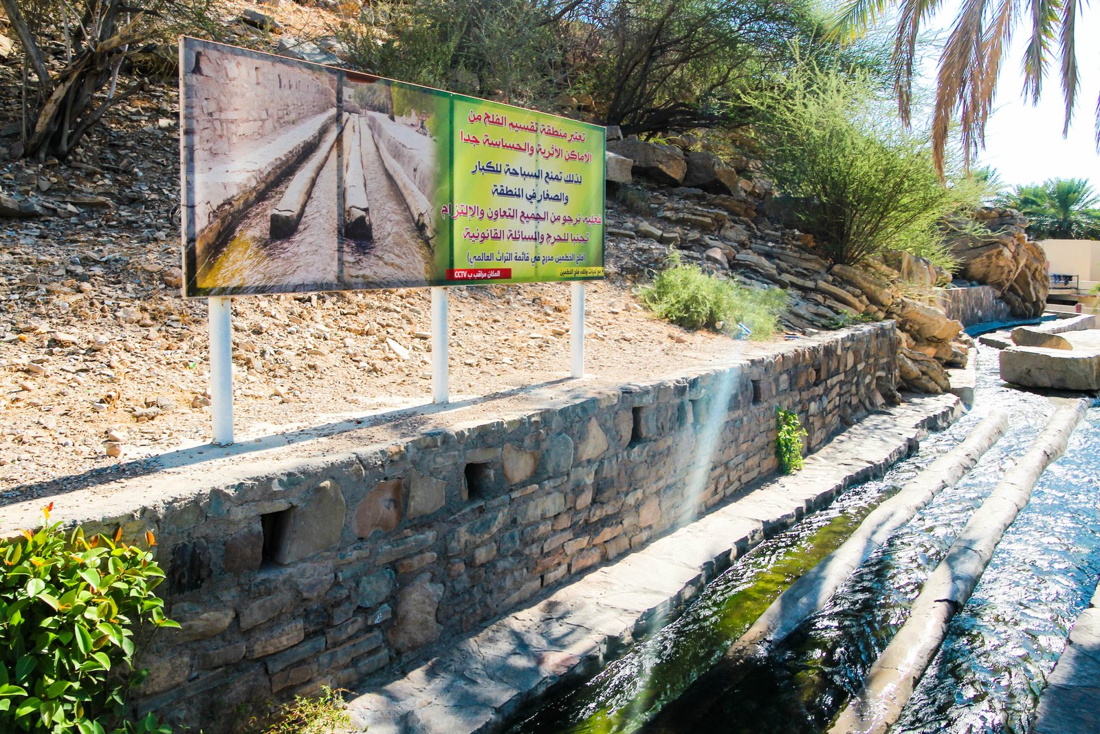
Oman has roughly 3,000 functioning aflaj — gravity-fed channels that draw water from underground aquifers or mountain springs and carry it, sometimes for dozens of kilometres, to date-palm oases and irrigated fields. The system was inscribed in 2006. Five examples were designated as representative: Falaj Daris and Falaj Al-Khatmain near Nizwa, and Falaj Al-Mayassar near the village of Al-Mudhaibi. The engineering principle dates back at least 3,000 years and predates any surviving written record of its construction.
Walking beside an active falaj, you hear the water before you see it — a low, steady sound against stone, surprisingly loud in the silence of an oasis. The channels are typically 40–60 centimetres wide, lined with cut stone or fired brick, and shaded in places by the palms that drink from them. In Birkat Al-Mawz, just north of Nizwa on the road from Muscat, Falaj Al-Khatmain runs through a cluster of mud-brick towers and date gardens that have changed little in outline since the medieval period. Local communities still regulate water rights using allocation systems — measured in units of time — that are centuries old and handed down orally.
The inscription recognises not just the physical infrastructure but the social and legal framework that keeps it operating: the falaj is a commons, maintained collectively by the villages it feeds. Visiting Nizwa on a Friday morning, when the weekly livestock market fills the square in front of the fort, gives the best sense of that continuity.
Getting there: Drive southwest from Muscat on Route 15 to Nizwa; approximately 175 km, 2 hours. Rental car or shared taxi. Allow: Half a day for falaj walk and Nizwa Fort combined; full day if adding the souk. Best for: Travellers interested in water engineering, vernacular architecture, and working agricultural landscapes.
Bahla Fort 200 km southwest — 2.5 hr by road
Bahla was the seat of power for the Banu Nabhan dynasty, who ruled central Oman from roughly the 12th to the 15th century and made the town a centre of Ibadi Islamic scholarship and traditional pottery. The fort they built — or rather, expanded from earlier foundations — is among the largest pre-modern structures in the Arabian Peninsula. UNESCO inscribed it in 1987, immediately placed it on the Danger List due to deterioration, and removed it in 2004 after a sustained restoration programme rebuilt significant sections of the mud-brick ramparts.
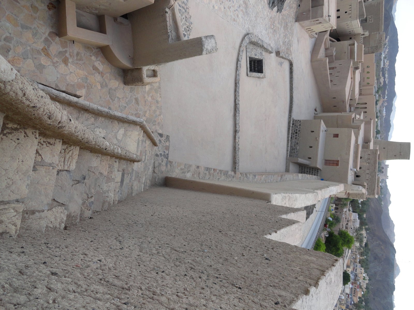
Standing at the base of Bahla Fort, the sheer scale of the outer wall reads as almost geological — pale ochre mud brick rising eight to ten metres, running for several kilometres around the town, punctuated by round towers whose silhouettes merge with the rocky scarp behind them. The interior is a warren of ramps and rooms that smell of earth and old plaster. Touch the walls and they are faintly warm even in the morning, retaining the previous day’s sun.
The town below the fort still produces the hand-thrown pottery — heavy, grey-buff vessels with incised geometric patterns — for which Bahla has been known for centuries. A small market near the entrance sells pieces that look virtually identical to shards excavated from the medieval layers. The falaj that serves Bahla is itself part of the inscribed zone, threading through the date-palm gardens on the fort’s western side.
Getting there: Continue 25 km beyond Nizwa on Route 21 toward Ibri; Bahla Fort is signposted in the town centre. Approximately 200 km, 2.5 hours from Muscat. Allow: 2–3 hours. Combine with Nizwa on a single day trip. Best for: History and architecture travellers; Islamic heritage; photography.
Archaeological Sites of Bat, Al-Khutm and Al-Ayn 270 km southwest — 3 hr by road
The cluster of Bronze Age towers and tombs near the village of Bat, inscribed in 1988, represents one of the densest concentrations of 3rd-millennium BC funerary architecture in the world. The builders — likely ancestors of communities that traded copper across the ancient Gulf — raised dozens of beehive-shaped stone towers and corbelled tomb chambers on a gravel plain at the foot of the Hajar Mountains. The stone is a pale limestone that turns almost white at midday, making the towers shimmer slightly against the bare rock behind them.
The towers at Al-Ayn, set along a ridge with a long view south toward the desert, are particularly well preserved. Each stands three to four metres high, the dry-stone coursework tight enough that almost no mortar was used. Archaeologists have not yet agreed on whether the towers served primarily as tombs, as territorial markers, or as communal charnel houses reused across generations. The uncertainty is part of what makes the site absorbing: you are looking at something built 4,500 years ago whose purpose remains genuinely open.
Getting there: From Bahla continue on Route 21 to Ibri, then follow signs toward Bat; approximately 270 km from Muscat, 3 hours. A rental car is necessary — no public transport serves this route. Allow: 2 hours on site; plan a full day from Muscat combining Bat with Bahla and Nizwa. Best for: Archaeology enthusiasts; travellers seeking genuinely off-tourist-circuit sites.
Ancient City of Qalhat 180 km southeast — 2 hr by road
Qalhat was the principal entrepôt of eastern Oman from the 11th to the early 16th century, handling trade in horses, dates, dried fish, and frankincense between the Gulf, India, and East Africa. Marco Polo described it around 1290 as a large and noble city. Ibn Battuta, who visited in 1332, praised its great mosque and noted that the harbour drew vessels from as far as China. UNESCO inscribed the site in 2018.
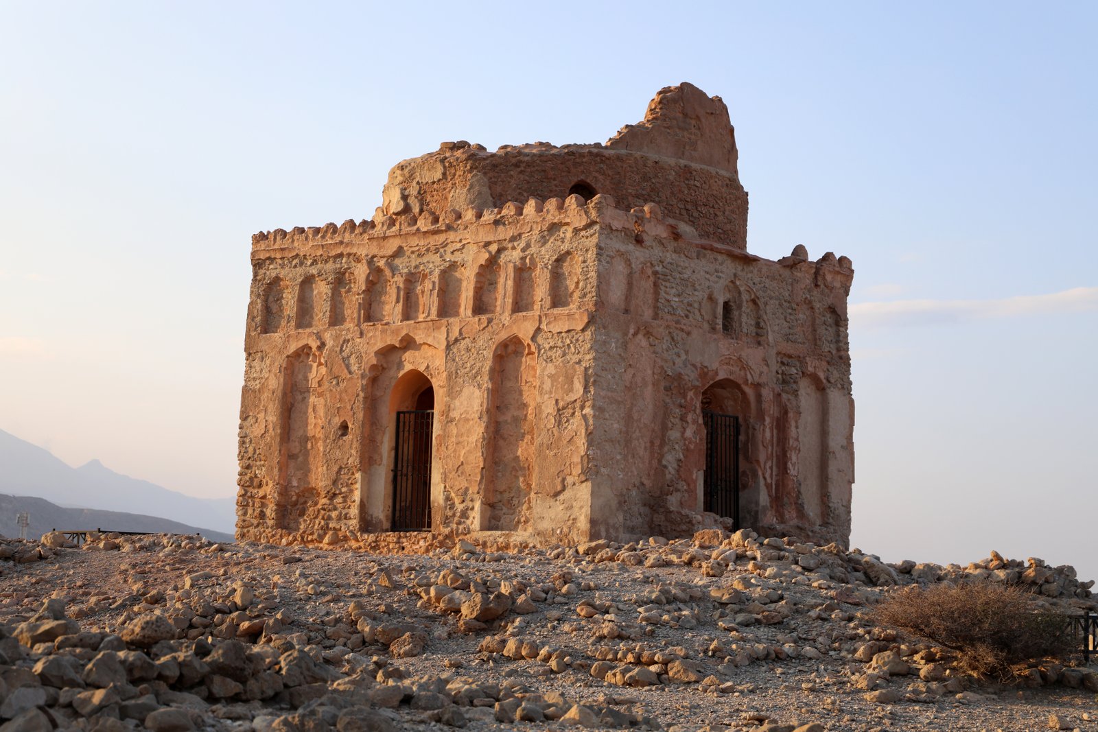
The ruins occupy a headland above the Gulf of Oman, about 180 kilometres southeast of Muscat near the town of Sur. The Portuguese destroyed much of the city in 1508 — Afonso de Albuquerque sacked it in reprisal for the sultan’s resistance — and an earthquake in 1508 completed the damage. What remains is the mausoleum of Bibi Miriam, a 14th-century structure with a carved stucco facade, and the footprint of the city wall running to the cliff edge. The wind off the water is constant and audible, channelled by the ruined ramparts into something that sounds almost like breath.
The mausoleum’s interior retains fragments of the original tilework: geometric patterns in blue-green and cream that align with 14th-century Persian ceramic traditions. A small visitor centre opened after the inscription and provides context for the excavated layers, which include Chinese porcelain, Indian cottons, and Omani copper objects that together map the city’s commercial reach.
Getting there: Drive southeast from Muscat on Route 23 toward Sur; Qalhat is signposted 20 km north of Sur. Approximately 180 km, 2 hours. Allow: 1.5–2 hours. Combine with Sur’s dhow-building yards for a full-day coastal itinerary. Best for: Medieval history; Indian Ocean trade networks; coastal landscape photography.
Land of Frankincense 1,000 km southwest — 2 hr by Oman Air domestic flight
The four sites that make up the Land of Frankincense — inscribed in 2000 — are all near Salalah in Dhofar, Oman’s southern province, and are reachable from Muscat only by a two-hour domestic flight or a full day’s drive. Wadi Dawkah preserves around 10,000 frankincense trees (Boswellia sacra) growing from bare limestone — the trunks short and pale, the bark papery, exuding resin in the heat that smells exactly like the incense it has supplied to temples and churches for three millennia. Khor Rori/Sumhuram is the ruin of an ancient port city from which Dhofari frankincense was shipped north and west; Al Baleed preserves a medieval Islamic city on the Salalah seafront; and Shisr/Ubar is the desert caravanserai that served as the terminal node of the southern trade route — the site briefly popularised as the “Atlantis of the Sands” after excavations in the 1990s.
Salalah is also the destination for the khareef (monsoon season, July–September), when clouds and mist roll in from the Arabian Sea and the Dhofar hills turn unexpectedly green. Visiting during this window makes the frankincense landscape particularly vivid — the trees against a wet grey sky, dripping resin, look nothing like the arid Arabian Peninsula of popular imagination.
Getting there: Oman Air operates multiple daily flights Muscat–Salalah, approximately 2 hours. Flying is strongly recommended; the drive is 1,000 km and requires an overnight stop. Allow: A minimum of 2 days to cover all four inscribed sites; 3–4 days recommended with Dhofar coastal scenery included. Best for: Travellers combining UNESCO heritage with the khareef landscape; history of the ancient incense trade.
Frequently Asked Questions
How many UNESCO World Heritage Sites are near Muscat?
Oman has five UNESCO World Heritage Sites in total. Four are reachable by road or short flight from Muscat: Aflaj Irrigation Systems of Oman (2006), Bahla Fort (1987), the Archaeological Sites of Bat, Al-Khutm and Al-Ayn (1988), and the Ancient City of Qalhat (2018). The fifth, the Land of Frankincense (2000), is near Salalah, approximately 1,000 km southwest, and requires a domestic flight.
How do I visit Bahla Fort from Muscat?
Drive southwest on Route 15 from Muscat to Nizwa (approximately 175 km, 2 hours), then continue 25 km further on Route 21 to Bahla — total around 200 km and 2.5 hours each way. A rental car is the most practical option; there is no reliable direct public transport. Combine the visit with Nizwa Fort and the falaj at Birkat Al-Mawz on the same day. Bahla Fort is open daily; admission is nominal. Early morning arrival avoids the midday heat and gives the best light for the ochre mud-brick walls.
Can I combine multiple UNESCO sites in one trip from Muscat, and what is the best season?
Bahla Fort, the Aflaj at Nizwa and Birkat Al-Mawz, and the Bronze Age sites at Bat can all be combined into a two-day road trip southwest of Muscat. Add Qalhat as a separate day trip southeast toward Sur. The best season for the interior sites is October through March, when daytime temperatures are manageable (20–30°C). Avoid June–August inland: temperatures regularly exceed 45°C. For the Land of Frankincense near Salalah, the khareef monsoon season (July–September) is actually an attraction in itself, with the hills turning green and cool.
What makes the Aflaj Irrigation Systems of Oman a UNESCO World Heritage Site?
The aflaj are recognised for both their engineering sophistication and the living social system that sustains them. The channels use gravity alone to move water from aquifers or mountain springs to oasis settlements, sometimes over distances of 30 km or more, with an accuracy of gradient that required precise surveying by pre-modern builders. UNESCO’s inscription in 2006 covered 3,000 functioning examples across Oman, emphasising that the system has operated continuously for at least 3,000 years. What sets it apart from comparable ancient irrigation networks is that it remains in active agricultural use today, maintained under communal water-rights agreements that predate Islam and have been adapted across centuries without ever being codified into formal law.

.jpg)

