
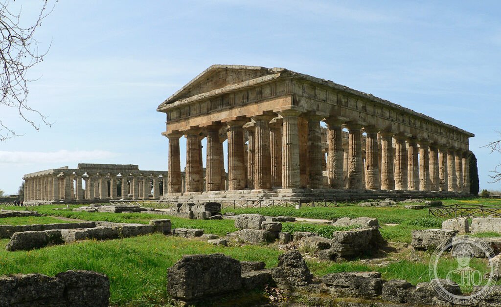
At Paestum three Doric temples of the sixth and fifth centuries BCE still stand side by side, letting visitors read a century of Greek architectural evolution in stone. The wider site, stretching into the Cilento hills and as far as the Certosa di Padula, is inscribed on the UNESCO World Heritage List.
At a glance
Paestum, known to its Greek founders as Poseidonia, lies on the Campanian coast south of Salerno. It forms part of a UNESCO World Heritage property inscribed in 1998, which groups the Cilento and Vallo di Diano National Park, the archaeological sites of Paestum and Velia, and the Certosa di Padula. Poseidonia was founded around 600 BCE by Greek colonists from Sybaris, after the fall of that city to its rival Croton; the Romans renamed it Paestum when it became a Latin colony in 273 BCE.
The three Doric temples at its heart, the Basilica, the Temple of Athena and the Temple of Hera II, were built roughly a century apart and together trace the passage from archaic to classical Doric design.
Key facts
- The Basilica: the oldest temple, around 550 BCE, measuring 54 by 24 metres with nine columns across the front rather than the conventional even number, and the most pronounced column entasis at Paestum.
- Temple of Athena: built around 510 BCE, 33 by 14 metres with six by thirteen columns; it was later used as a Christian church between 590 and 1000 CE.
- Temple of Hera II: built 460–450 BCE, 60 by 24 metres with six by fourteen columns; its outer colonnade, pronaos, cella and opisthodomos all survive, making it one of the most complete Doric temples known, with a far shallower column entasis than the Basilica.
- Tomb of the Diver: a Lucanian painted tomb of the fifth century BCE, unique for showing a diver in Greek funerary art, displayed in the Museo Nazionale di Paestum.
- Certosa di Padula: a Carthusian charterhouse founded in 1306 CE, whose main cloister, at 152 by 152 metres, is said to be the largest in the world.
History
Poseidonia was laid out on an orthogonal street grid at its founding around 600 BCE, with sacred areas dedicated to Hera in the south of the city and, later, to Athena on its highest point. Around 400 BCE the Lucanians, an Italic people from the southern Apennines, gradually took political control of the city through settlement rather than conquest, and it is from this Lucanian period that the celebrated painted tombs date, including the Tomb of the Diver, whose imagery has been read either as a symbol of the soul’s passage to the afterlife or as a reference to athletic victory.
The Romans made Paestum a Latin colony in 273 BCE, Latinising its name from Poseidonia. Centuries later and inland, the Certosa di Padula was founded in 1306 CE by Tommaso Sanseverino for the Carthusian order, with construction continuing until 1764 CE; its own chronicle records that the monks once prepared a vast frittata for the army of Emperor Charles V passing through in 1535, though the story does not appear in the emperor’s own travel diary. The wider Cilento and Paestum landscape, including the Certosa, was inscribed on the UNESCO World Heritage List in 1998.
What you see
The three temples are approached in sequence from south to north: the Basilica, the larger Temple of Hera II, and finally the Temple of Athena. Within the same archaeological area stands the Roman-era forum built over the Greek city, and the Ekklesiasterion, a circular stepped assembly space from the Greek agora. The adjoining Museo Nazionale di Paestum houses the Tomb of the Diver in a dedicated room, its wall and ceiling panels reassembled as they were found, along with further Lucanian painted tombs.
At the Certosa di Padula, the main draw is the vast cloister, walked in full around its 608-metre perimeter, together with the monks’ cells, the chapter house and the kitchen, where the pan said to have cooked the emperor’s frittata is on display.
Practical information
- Tickets and hours: the archaeological park and the Museo Nazionale di Paestum are covered by the same admission; current times and prices are best checked on the park’s official channels before visiting.
- Certosa di Padula: keeps its own separate hours, also best confirmed with the site directly.
- Access: there is no public transport link between Paestum and the Certosa di Padula, so a car is needed to combine both in one day.
Getting there
The main entrance to the Parco Archeologico di Paestum, on Via Magna Grecia, sits at coordinates 40.4215° N, 15.0046° E. The Certosa di Padula lies further inland, reached by road via the SS19, and is best visited by car given the absence of public transport connections.
Nearby
- Museo Nazionale di Paestum — adjacent to the temples, home to the Tomb of the Diver and further Lucanian tombs.
- Velia — the ancient Elea, founded around 540 BCE, part of the same UNESCO listing and seat of the Eleatic school of philosophy.
- Certosa di Padula — around 35 kilometres away, with the largest cloister claimed anywhere in the world.
- Cilento and Vallo di Diano National Park — the surrounding protected landscape that frames the whole UNESCO property.
Sources
- UNESCO
- Museo Nazionale di Paestum
- Zanker (1975)
- Boardman (1988)
Find it on the map
See this place and what’s around it →📷 Become a Cultural Heritage Online photographer
Share your photos of places: they stay published under your name as the author. The more they're seen, the more you get noticed — and soon a contest will reward the most appreciated photos.
Log in or sign up free to add a photo