
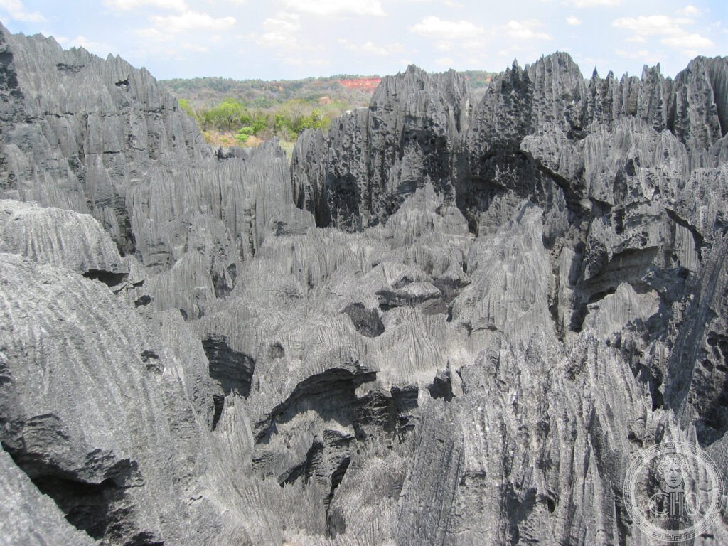
A forest of razor-edged grey limestone needles rising from the karst of western Madagascar, so sharp the Malagasy name means ‘where one cannot walk barefoot’. Reaching it means a dirt road, a river crossing by pirogue, and a via ferrata through the pinnacles themselves.
At a glance
The Tsingy de Bemaraha Strict Nature Reserve and National Park covers 152,000 hectares of the Bemaraha plateau in the Melaky Region of western Madagascar. Its limestone was laid down as marine sediment during the Jurassic period, roughly 200 to 145 million years ago, then lifted above sea level by tectonic uplift. Millions of years of slightly acidic rainwater working along the rock’s joints and bedding planes dissolved it into the forest of pinnacles known as tsingy, some rising 30 to 50 metres above the karst floor in the Grand Tsingy, the reserve’s most dramatic and most visited section.
The habitat has produced its own endemic wildlife, including seven species of lemur, blind albino cave fish and cave crabs found nowhere else, and around fifty-three bird species. Decken’s sifaka, a large white-furred lemur with tan markings, is often seen clinging to and leaping across the vertical limestone faces.
Key facts
- Area: 152,000 hectares of limestone karst on the Bemaraha plateau
- Status: Strict Nature Reserve since 1927, National Park since 2007, UNESCO World Heritage Site since 1990
- Name: tsingy is Malagasy for ‘where one cannot walk barefoot’, a literal description of the razor-sharp rock
- Wildlife: seven lemur species including Decken’s sifaka, blind cave fish, cave crabs and around fifty-three bird species
- Access season: reachable only in the dry season, roughly May to November
History
The area was first protected in 1927 by the French colonial administration as a strict nature reserve, part of a wider system set up in the 1920s to safeguard Madagascar’s endemic wildlife and habitats. Under that status human settlement and resource extraction were prohibited, and surrounding Sakalava communities were excluded from the reserve, a decision that created lasting tension between conservation and local needs.
In 2007 the area was redesignated as a national park, adding a buffer zone with limited permitted human use. The neighbouring villages of Bekopaka and Antsiraraka became the gateway communities for ecotourism, and guiding is now provided by, and required from, local residents.
What you see
The interior of the tsingy can only be explored via fixed climbing circuits installed by the park authority, using ropes, iron rungs and suspension bridges in a via ferrata style. The main Grand Tsingy circuit runs for several hours over roughly four kilometres, climbing fixed ropes up the limestone faces, threading narrow passages between the pinnacles, and crossing two aerial bridges suspended high above the crevices below. It calls for a reasonable head for heights and the ability to climb ladders. The shorter Petit Tsingy circuit covers the same karst geology on a smaller and less exposed scale, and suits visitors uncomfortable with heights or travelling with children.
The journey in is part of the experience. The road from Morondava to Bekopaka crosses the Manambolo River by wooden pirogue ferry, and the river itself has cut a deep canyon through the plateau, its grey limestone walls patrolled by Nile crocodiles along the banks.
Practical information
- Season: the site is accessible only in the dry season, from around May to November; the wet season makes the roads impassable and the river uncrossable
- Guides and equipment: a local guide is mandatory for both circuits, and a climbing harness is required for the Grand Tsingy
- Accommodation: a handful of simple lodges in Bekopaka offer solar power and meals, though running water is limited
- Duration: allow at least two full days at the site to cover both the Grand and Petit Tsingy circuits, three if time allows
Getting there
The usual route starts at Morondava, which has an airport connected to Antananarivo. From there it is roughly two hundred kilometres by dirt road, the RN35 and RN8, to Bekopaka, requiring a 4WD vehicle and at least one river crossing by ferry, plus the pirogue crossing of the Manambolo gorge itself. The whole return trip from Morondava, including time at the Tsingy, typically needs several days and is only feasible in the dry season.
Nearby
- Avenue of the Baobabs — near Morondava, a dirt road lined with towering Grandidier’s baobabs, remnants of ancient forest cleared for farmland and considered sacred locally; the site sits outside the UNESCO inscription but draws the most visitors of any single spot in western Madagascar
- Kirindy Forest — around sixty kilometres north of Morondava, a dry deciduous forest known for nocturnal wildlife, including the rare Malagasy giant jumping rat and the fossa, Madagascar’s largest native carnivore, most often seen during its September to October mating season
Sources
- Wikipedia
- UNESCO
Find it on the map
See this place and what’s around it →📷 Become a Cultural Heritage Online photographer
Share your photos of places: they stay published under your name as the author. The more they're seen, the more you get noticed — and soon a contest will reward the most appreciated photos.
Log in or sign up free to add a photo