
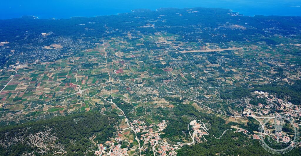
On the island of Hvar, a plain of dry-stone walls still divides the fields exactly as Greek settlers laid them out in the 4th century BCE. Farmed without interruption ever since, it is one of the best-preserved ancient agricultural landscapes anywhere in the Mediterranean.
At a glance
The Stari Grad Plain is the fertile limestone plain behind the town of Stari Grad on Hvar, laid out as the agricultural hinterland, or chora, of the Greek colony of Pharos. Founded by settlers from the island of Paros in the 4th century BCE, the colony organised its farmland into a geometric grid of rectangular parcels divided by dry-stone walls, known locally as trimia. That grid, covering roughly 24.5 square kilometres, still structures the fields today, planted with olives, vines and, more recently, lavender.
Key facts
- Location: Stari Grad, Island of Hvar, Split-Dalmatia County, Croatia
- Founded: Greek colony of Pharos, 4th century BCE, recorded by the historian Diodorus Siculus
- Area: approximately 24.5 km² of cadastral grid
- Parcel size: around 181 by 905 metres, based on the Parian stade (roughly 181 metres)
- Status: UNESCO World Heritage Site, inscribed 2008
- Coordinates: 43.1830° N, 16.6300° E
History
The colony of Pharos was established by settlers from Paros, with the plain laid out as its organised agricultural territory. Control of the island passed through the Illyrian kingdom, whose ruler Agron and later his widow Teuta held sway over much of the Adriatic coast until Roman intervention in the First Illyrian War of 229–228 BCE brought the region under Roman influence. Under Roman rule the island, known as Pharia, became a producer of wine and olive oil for the Roman market, and the agricultural grid stayed in continuous use.
Successive rulers followed, Byzantine, Croatian, Venetian, French Napoleonic, Habsburg and Yugoslav, and while ownership of the land changed hands repeatedly, its use as farmland never stopped. The dry-stone walls marking the ancient parcels have been maintained, rebuilt and repaired by generations of farmers, with some sections surviving from the original construction.
What you see
The plain lies immediately behind Stari Grad, itself regarded as the oldest town in Croatia and founded by the same Greek settlers, whose ancient agora forms the town’s main square today. The 16th-century Tvrdalj, the fortified residence built by the Croatian Renaissance poet Petar Hektorović, with its garden and fishpond, stands in the old town.
Walking or cycling the plain’s perimeter takes a few hours, and the geometric pattern of walls and fields is best appreciated from higher ground on the northern edge, reached by a short climb. Close up, the dry-stone walls reveal limestone blocks weighing tens of kilograms, set without mortar using a technique unchanged for over two thousand years. Olives and vines grow within the old Greek parcels, and since the 19th century lavender has been cultivated there too, its purple bloom in June and July set against the grey stone walls.
Practical information
- Access: the plain is reached on foot or by bicycle directly from Stari Grad; bicycles can be hired in the town centre
- Best time to visit: May and June, when cereal crops within the old parcels are green-gold, or late June into July for the lavender bloom; August is the busiest and hottest month
- Getting around: a circuit of the plain’s perimeter takes a few hours on foot
- Further information: check current transport and access details through official ferry and tourism channels before travelling
Getting there
Hvar is reached via Split Airport, followed by a Jadrolinija car ferry from Split to Stari Grad, or a passenger catamaran from Split to Hvar Town. The Stari Grad Plain begins right behind the ferry port at Stari Grad. Current schedules and fares should be checked directly with the ferry operator.
Nearby
- Hvar Town — about 20 km west, with a Venetian Renaissance main square, the Cathedral of St Stephen, the Spanish Fortress overlooking the harbour, and a well-known yacht marina
- Vis Island — about an hour by catamaran, a former Yugoslav military base with limited development, home to the Vugava grape and the ancient Greek colony of Issa, thought to be slightly older than Pharos
- Biševo — near Vis, known for the Blue Cave
Sources
- Wikipedia, Stari Grad Plain
- Wikipedia, Pharos (Hvar)
- Wikipedia, Hvar
- UNESCO, Stari Grad Plain, WHS reference 1240
Find it on the map
See this place and what’s around it →📷 Become a Cultural Heritage Online photographer
Share your photos of places: they stay published under your name as the author. The more they're seen, the more you get noticed — and soon a contest will reward the most appreciated photos.
Log in or sign up free to add a photo