
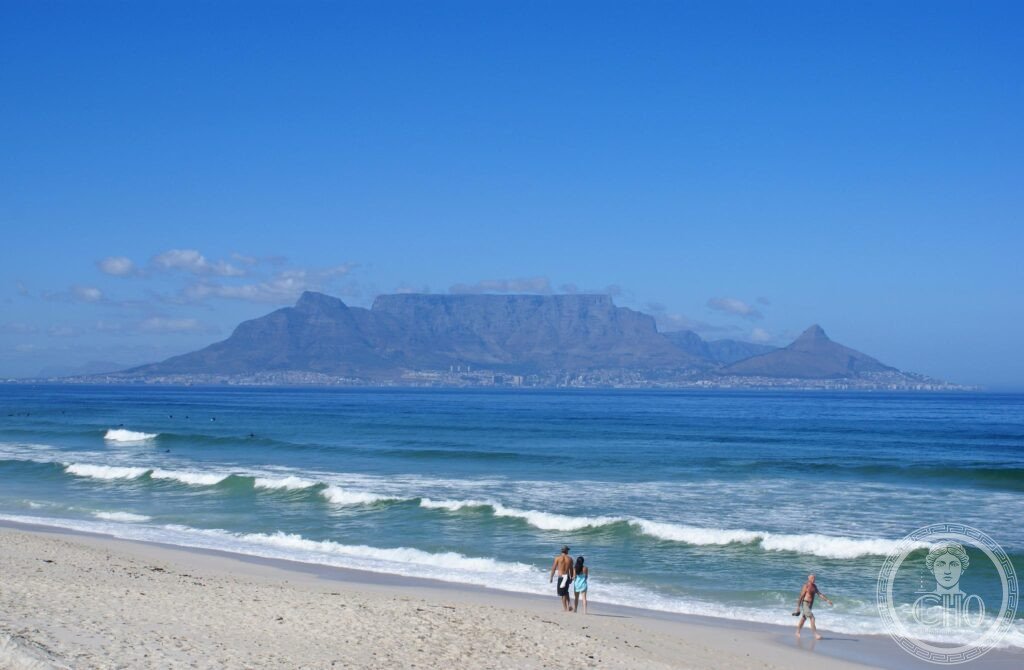
Table Mountain’s flat sandstone summit, often crowned by a cloud known locally as the Tablecloth, forms the backdrop to Cape Town and shelters plant life richer than that found across the whole of the British Isles. A rotating cable car reaches the plateau, opening a wide view across the city, the Atlantic and Robben Island.
At a glance
Table Mountain’s summit forms a plateau about three kilometres wide, giving Cape Town its flat-topped skyline. When the south-easterly wind known as the Cape Doctor blows over the summit, cloud spills over the edge and evaporates before reaching the base, a phenomenon known locally as the Tablecloth.
The mountain lies within the Cape Floral Region Protected Areas, inscribed as a UNESCO World Heritage Site in 2004, and its slopes hold around 2,200 plant species, more than grow across the whole of the British Isles, with roughly seven in ten found nowhere else. In 2011 Table Mountain was named one of the New Seven Wonders of Nature.
Key facts
- Height: the summit plateau reaches 1,086 metres at Maclear’s Beacon, its highest point, and is roughly three kilometres across.
- Cable car: the Table Mountain Aerial Cableway opened in 1929 and was rebuilt in 1997 with cars whose floor rotates during the ascent.
- Geology: the summit sandstone is thought to be around 600 million years old, resting on a granite base formed by an intrusion roughly 540 million years ago.
- Biodiversity: part of the Cape Floral Region Protected Areas, a UNESCO World Heritage Site inscribed in 2004, with around 2,200 plant species recorded on the mountain.
- Recognition: voted one of the New Seven Wonders of Nature in 2011.
History
The Portuguese navigator António de Saldanha is credited with the first recorded European ascent of Table Mountain, in 1503, climbing it to survey the bay below. Nearly a century and a half later, in 1652, the Dutch East India Company established a provisioning station at the Cape under Jan van Riebeeck, and Cape Town grew around it as a stop for ships travelling between Europe and Asia.
A cable car to the summit opened in 1929 and was rebuilt in 1997 with the rotating cars still in use today. The mountain’s place within the Cape Floral Region Protected Areas was recognised by UNESCO in 2004, and in 2011 it was named among the New Seven Wonders of Nature.
What you see
The summit is a plateau crossed by walking trails rather than a single viewpoint, with Maclear’s Beacon marking its highest point. On a clear day the views extend in every direction, taking in the city below, the Atlantic coastline and Robben Island lying in Table Bay to the north, the island where Nelson Mandela was imprisoned for eighteen of his twenty-seven years in custody.
Practical information
- Cable car conditions: the cableway does not run in high wind, rain or thick cloud, so it is worth checking conditions with the operator before setting out.
- Hiking option: several trails climb the mountain for those who prefer to walk; the Platteklip Gorge route is the most used, clearly marked but steep, and hikers should carry water and sun protection and avoid going alone.
- Cable car station: the lower station stands on Tafelberg Road, on the mountain’s lower slopes.
Getting there
Cape Town International Airport serves the city. The cable car’s lower station is on Tafelberg Road, reached by road from the city centre.
Nearby
- Robben Island — about 12km offshore in Table Bay, reached by ferry from the V&A Waterfront; the former prison where Nelson Mandela was held is a UNESCO World Heritage Site, inscribed in 1999, with tours guided by former political prisoners.
- Boulders Beach — about 45km south near Simon’s Town, home to a colony of African penguins that grew from two breeding pairs when it was established in 1982.
- Cape of Good Hope — about 45km away by road; historically seen as the point where ships passed from the Atlantic into the Indian Ocean, and first rounded by Bartolomeu Dias in 1488. The true southernmost point of Africa is Cape Agulhas, some 150km further east.
- Stellenbosch and Franschhoek — about 50km east, at the heart of the Cape Winelands, with Cape Dutch gabled architecture and Franschhoek’s history as a settlement of French Huguenot refugees from 1688.
Sources
- Wikipedia
- UNESCO, Cape Floral Region Protected Areas (WHS reference 1007bis, inscribed 2004)
- New7Wonders Foundation, New Seven Wonders of Nature, 2011
Find it on the map
See this place and what’s around it →📷 Become a Cultural Heritage Online photographer
Share your photos of places: they stay published under your name as the author. The more they're seen, the more you get noticed — and soon a contest will reward the most appreciated photos.
Log in or sign up free to add a photo