
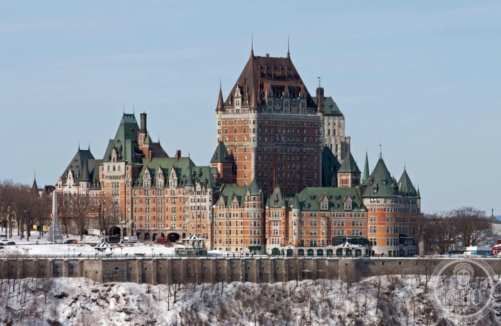
Old Québec is the only walled city surviving north of Mexico, its stone ramparts and steep cliff-top streets tracing nearly two centuries of French and British colonial rule. Above the St Lawrence stands the turreted Château Frontenac, while below, the Plains of Abraham mark the ground where the fate of New France was decided in a single autumn morning.
At a glance
The Historic District of Old Québec sits on Cap Diamant, a cliff above the St Lawrence River at the point where the waterway narrows sharply, a feature that gave the city its name from the Algonquin word Kebec. Founded by Samuel de Champlain on 3 July 1608, it served as the capital of New France, the vast French colonial territory that once stretched from Hudson Bay towards the Gulf of Mexico, before passing to British control in 1763.
Quebec City remains overwhelmingly French-speaking, a rare survival of French colonial culture in North America alongside New Orleans. Its Upper and Lower Town, divided by the cliff, retain much of their historic street pattern and stone architecture, enclosed by one of the last complete circuits of city walls on the continent.
Key facts
- Founded: 3 July 1608, by Samuel de Champlain
- Fortifications: around 4.6 km of walls, built and altered from the 1690s through the early 19th century, first under French then British engineers
- Surviving gates: Porte Saint-Louis, Porte Saint-Jean, Porte Kent and Porte Prescott
- Château Frontenac: opened 1893, designed by Bruce Price for the Canadian Pacific Railway
- Battle of the Plains of Abraham: fought 13 September 1759 between British forces under James Wolfe and French forces under the Marquis de Montcalm
- Heritage status: inscribed as a UNESCO World Heritage Site in 1985
History
Champlain established Québec in 1608 as the anchor of New France, choosing the Cap Diamant cliff for its command of the narrowest navigable stretch of the St Lawrence. For a century and a half the city was the administrative and religious centre of French North America, its economy built on the fur trade, above all the export of beaver pelts for the European felt hat industry, and its early history recorded in detail by Jesuit missionaries in their annual reports to Paris, known as the Jesuit Relations.
The colonial period ended on the Plains of Abraham on 13 September 1759, when British troops under General James Wolfe scaled the cliff by a poorly guarded path and met French forces under the Marquis de Montcalm on the plateau above the city. The battle was brief and decisive; both commanders were mortally wounded, and Québec surrendered five days later. France formally ceded its North American territories to Britain under the Treaty of Paris in 1763.
Under British rule, the Quebec Act of 1774 guaranteed French Canadians the right to practise Catholicism and retain French civil law, a concession credited with preserving the city’s French character within British North America. The walls themselves were substantially rebuilt and extended by British military engineers between the 1760s and 1830s, giving them much of their present form.
What you see
A walkway runs along the top of the city walls, giving views over the St Lawrence to the east and the Grande Allée boulevard to the west, and passing close to the surviving gates, including the neo-Gothic Porte Saint-Louis, rebuilt in 1878 after public protest at the demolition of the original structure.
The Château Frontenac dominates the Upper Town skyline, its turrets and copper roofs visible from across the river; the hotel hosted Allied planning conferences during the Second World War, and its meeting rooms survive. In front of it, the Dufferin Terrace, a long wooden boardwalk, offers views over the Lower Town and river, and in winter carries a toboggan run said to date back to amusements built by the British garrison.
Below the cliff, the Plains of Abraham form a large park where the 1759 battle was fought; within it stand Martello towers, circular defensive structures built by the British after the conquest, one of which houses a museum devoted to the battlefield’s history.
Practical information
- Access to the walls: the ramparts promenade is open to walkers; check the city’s official heritage or tourism channels for current access points and any seasonal closures
- Château Frontenac: the hotel operates as a working property; tours and access details are published by Fairmont directly
- Plains of Abraham: the park and its museum are managed as a historic site; current visiting arrangements are best confirmed through the official Battlefields Park authority
Getting there
Old Québec occupies the historic core of Quebec City, on a cliff above the St Lawrence River, with the Château Frontenac and city walls forming a compact walkable district in the Upper Town.
Nearby
- Dufferin Terrace — the boardwalk in front of the Château Frontenac, overlooking the Lower Town and river
- Plains of Abraham — the battlefield park just outside the walls, with its Martello tower museum
- Rue du Petit-Champlain — a Lower Town street reached from the Terrace by the historic toboggan run
- Porte Saint-Louis — the most prominent of the surviving city gates, on the ramparts walk
Sources
- Musée des Plaines d’Abraham
- Benjamin West, The Death of General Wolfe (1770)
- Jesuit Relations
- Fairmont Le Château Frontenac
Find it on the map
See this place and what’s around it →📷 Become a Cultural Heritage Online photographer
Share your photos of places: they stay published under your name as the author. The more they're seen, the more you get noticed — and soon a contest will reward the most appreciated photos.
Log in or sign up free to add a photo