
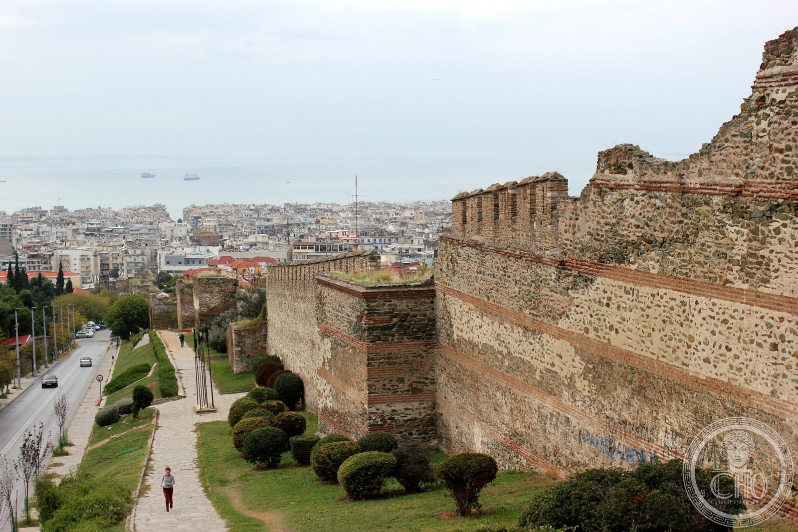
Four kilometers of fortified masonry encircle the medieval city, their Byzantine stones a testament to a millennium of defense and transformation across empires.
At a glance
The Walls of Thessaloniki are a 4-kilometer defensive circuit constructed in the early Byzantine period around 390, though they incorporate earlier late 3rd-century stonework. Built in the characteristic late Roman style of alternating ashlar masonry and brick bands, they served as the city’s primary fortification through the Ottoman period until large sections were demolished in the late 19th century as part of urban restructuring.
History
Thessaloniki was fortified from its establishment in the late 4th century BC, but the walls visitors see today largely date from the early Byzantine era, ca. 390. These walls incorporate sections of an earlier defensive line built in the late 3rd century, creating a palimpsest of Roman and Byzantine construction techniques. The fortifications remained in use throughout the medieval period and continued to define the city’s boundaries under Ottoman rule until the late 19th century, when significant portions—including the entire seaward section—were demolished as the Ottoman authorities restructured Thessaloniki’s urban layout.
What you see
The walls exemplify late Roman military engineering: courses of shaped stone alternate with bands of brick in patterns both structural and decorative. The northern section adjoins the city’s acropolis, which functioned as a separate fortified enclosure. Within the acropolis stands the Heptapyrgion (Seven Towers), known colloquially by its Ottoman name, Yedi Kule—a citadel that reinforced the primary defensive system. The mixed masonry technique provided both strength and flexibility, allowing repairs and modifications across centuries of use.
Cultural significance
As part of the Paleochristian and Byzantine monuments of Thessaloniki, the walls were inscribed on the UNESCO World Heritage List in 1988 in recognition of their outstanding Byzantine architecture. They represent a critical physical link between classical antiquity, the Byzantine Empire, and the Ottoman period—embodying the city’s role as a major Mediterranean fortress and crossroads of civilizations.
Key facts
- Country: Greece
- City: Thessaloniki
- Period: Early Byzantine (ca. 390), incorporating 3rd-century elements
- Length: 4 kilometers
- Coordinates: 40.6425°N, 22.9544°E
- UNESCO World Heritage status: Inscribed 1988 (Paleochristian and Byzantine Monuments of Thessaloniki)
Practical information & getting there
The Walls of Thessaloniki are distributed throughout the city and can be accessed on foot from various points. Large sections remain visible, particularly in the northern districts near the acropolis. The Heptapyrgion (Yedi Kule) is a prominent landmark within the fortified zone. Thessaloniki has excellent transport connections by air, rail, and road; consult local tourism information for current visiting conditions and guided heritage tours.
Sources & resources
Find it on the map
See this place and what’s around it →
📷 Become a Cultural Heritage Online photographer
Share your photos of places: they stay published under your name as the author. The more they're seen, the more you get noticed — and soon a contest will reward the most appreciated photos.
Log in or sign up free to add a photoIs this page about you?
This page is read by travellers and heritage enthusiasts who find it on Google. Tell us how you are connected to this place and we will take it from there.