

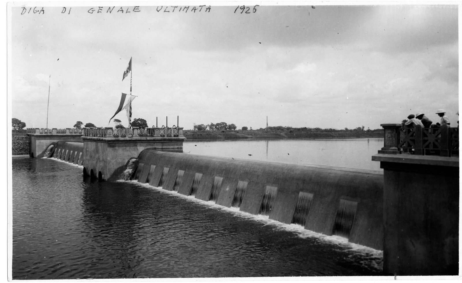
On the lower Shabelle, an intake dam finished in 1926 fed the canals that watered the largest Italian colonial farming scheme in Somalia.
At a glance
Genale sits on the lower Uebi Scebeli, the Shabelle River, about 15 kilometres from Marka in southern Somalia. From 1924 Italian settlers turned the surrounding plain into an irrigated farming district, made possible by a barrage across the river that diverted its water into a network of canals. The dam was an intake structure rather than a storage reservoir. Cotton came first; by the 1930s the land grew bananas, and after the colonial state created a banana monopoly in 1936 the Genale–Merca zone handled roughly nine-tenths of Somalia’s banana exports. The town is called Janale today.
Key facts
- River: lower Uebi Scebeli (Shabelle), about 13.5 km from the Indian Ocean near Merca
- Barrage: completed 1926; an intake weir, not a storage dam
- Promoted by: Cesare Maria De Vecchi, governor of Italian Somalia 1924–1928
- Irrigation: two main canal systems feeding an estimated 25,000–30,000 hectares of concessions between Genale, Merca and Vittorio d’Africa
- Settlement: founded 1924 by colonists from Turin; about 100 farms totalling some 20,000 hectares
- Crops: cotton until about 1931, then bananas, castor, groundnut, cassava, tobacco and fodder
- Trade: under the Regia Azienda Monopolio Banane (1936), Genale–Merca managed about 90% of Somali banana exports
History
The district began in 1924, when a group of settlers from Turin took land on the lower Shabelle under the supervision of the colonial governor, Cesare Maria De Vecchi. Their farms depended on a single piece of engineering: a barrage thrown across the river to raise its level and turn it into two main canals. The completed dam is dated 1926. It was built as an intake, drawing river water off into the canal network rather than holding a reservoir behind it, and it commanded an estimated 25,000 to 30,000 hectares of concessions running toward Merca and the coast.
The concession land was parcelled among roughly a hundred farms, most between 75 and 600 hectares and averaging around 200, for a total near 20,000 hectares. Cotton was the first cash crop; by the early 1930s bananas replaced it. In 1936, as Mussolini declared the Italian East African Empire, the colonial state absorbed the private shipping trust and founded the Regia Azienda Monopolio Banane (RAMB), a monopoly that controlled the Italo-Somali banana trade from planting to sale and required every grower to sell to the government. RAMB closed older inland plantations, including the Villaggio Duca degli Abruzzi consortium, and concentrated production near the coast, so that Genale–Merca came to handle about 90% of Somalia’s banana exports.
Labour, not land, was the scheme’s central difficulty. Somali farmers were reluctant to work the plantations, and De Vecchi introduced harsh methods to compel them; forced labour also spread through the hut tax levied on the population. The scheme’s output figures were built on that coercion. The Italian settlement dissolved after the Second World War, and the place is now the Somali town of Janale.
What you see
The best record of Genale is a set of photographs taken in 1926. The completed barrage runs low across the Shabelle, its crest stepped so the water breaks into a row of vertical falls; a central pier carries a flag and an ornamented parapet, and colonial officials in pith helmets stand on the far abutment. Upstream the river widens into the flat, tree-lined plain the canals were built to water.
Other frames show the work itself: Somali labourers, barefoot and carrying loads on their heads, moving concrete up ramps past the curved dam body while iron reinforcing rods stand ready in the formwork. A further view looks straight down the main canal in operation, a still ribbon of water between raised earth banks and rows of young trees, running to the horizon. Together the images document both the engineering and the hands that raised it.
Practical information
- Access: Lower Shabelle is a conflict-affected region; the site is not open to visitors, and this card is an archival record rather than a travel guide.
- Today: the settlement is the Somali town of Janale, with a population of a few thousand.
- Best sources: the 1926 photographs on Wikimedia Commons and the scholarly literature listed below.
Getting there
Genale/Janale lies on the lower Shabelle about 15 kilometres inland from Marka (Merca) and roughly 90 kilometres south-west of Mogadishu. The barrage sits on the river at the town. Because of the security situation in Lower Shabelle, the area is not currently reachable by travellers; the location is given for reference and mapping.
Nearby
- Marka (Merca): the coastal town about 15 km downstream, the district’s outlet to the sea.
- Villaggio Duca degli Abruzzi (Jowhar): the SAIS company town upriver, whose consortium RAMB shut down in favour of the Genale–Merca zone.
- Mogadishu: the colonial capital, about 90 km to the north-east.
Sources
- “Genale,” Enciclopedia Italiana, Treccani — location, experimental estate, barrage on the Uebi Scebeli, crops.
- “Genale” and “Ganale Doria (dam),” English Wikipedia — 1924 foundation, farms and hectares, the 1926 intake barrage, De Vecchi, canal capacities, cotton-to-banana shift.
- Diana Garvin, “Fruit of Fascist Empire: Bananas and Italian Somaliland,” The Italianist (2023) — the 1936 RAMB monopoly, Genale–Merca at 90% of exports, and plantation labour under coercion.
- Historic photographs (1926): Wikimedia Commons, uploader Dormiglione, CC BY-SA 4.0.
Find it on the map
See this place and what’s around it →Record researched and written by Luigi De Marchi for Cultural Heritage Online, 2026.

📷 Become a Cultural Heritage Online photographer
Share your photos of places: they stay published under your name as the author. The more they're seen, the more you get noticed — and soon a contest will reward the most appreciated photos.
Log in or sign up free to add a photo