
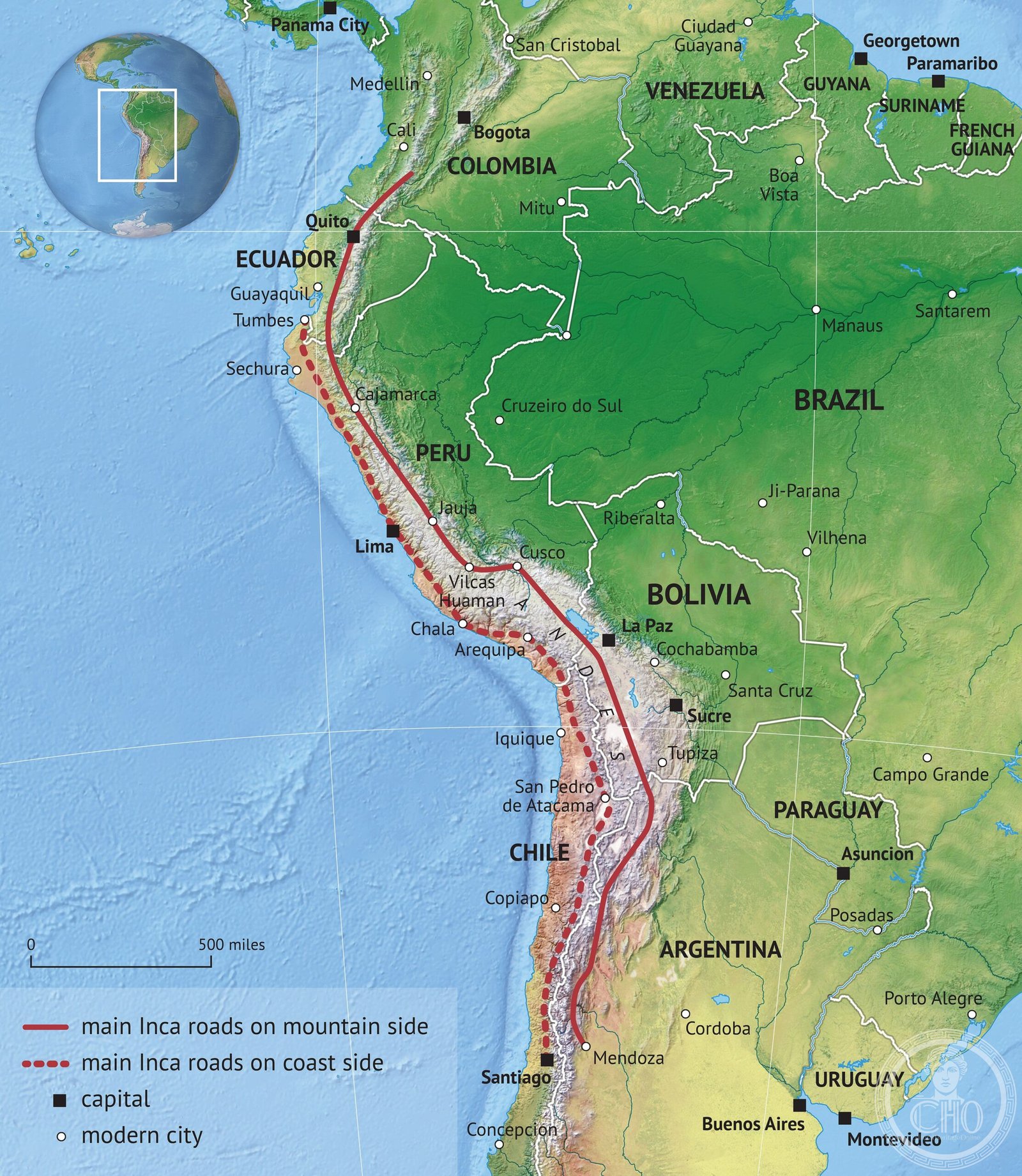
Spanning roughly 40,000 kilometres across the Andes and coastal plains, the Qhapaq Ñan was an engineering marvel that connected the vast Tawantinsuyu empire without the use of wheels, moving goods, armies and messengers across some of the world’s most challenging terrain.
At a glance
The Inca road system was the most extensive and advanced transportation network in pre-Columbian South America. It stretched across nearly two million square kilometres and served a population of approximately twelve million. The network remains partially intact, with some sections heavily used by modern trekkers exploring routes like the famous Inca Trail to Machu Picchu.
History
Parts of the road network were built by cultures predating the Inca Empire, including the Wari in northern central Peru and the Tiwanaku in Bolivia. The Inca later expanded and integrated these routes into a unified imperial system, transforming them into carefully planned, engineered and maintained pathways that bound their empire together.
A 2021 study revealed that the roads’ effects persisted for over five centuries, with communities within twenty kilometres of the network showing higher wages, better nutrition and greater school attendance than distant settlements.
What you see
The roads were engineered with remarkable sophistication. They featured paved sections, stone stairways ascending steep slopes, bridges spanning gorges and drainage systems managing water flow. Retaining walls stabilised hillsides and held the paths in place across unstable terrain.
Strategic structures punctuated the routes at regular intervals: relay stations housed chasquis, the running messengers who carried information across the empire; tambos provided shelter and supplies at one-day walking intervals; administrative centres called qullqas stored goods for redistribution; and pukaras—fortresses—guarded the empire’s boundaries and newly conquered territories.
Cultural significance
The road system enabled unprecedented imperial integration. Without wheels, the Inca moved vast armies, redistributed resources across diverse climates and maintained administrative control over a territory of staggering scale and geographic complexity. This network can be compared directly with the Roman road system, though it was built a thousand years later.
Today, UNESCO and the IUCN collaborate with governments and communities across all six countries to protect this heritage. The Inca Trail to Machu Picchu remains the most celebrated section, drawing thousands of international trekkers annually.
Key facts
- Total length: approximately 40,000 kilometres
- Territory covered: nearly 2,000,000 square kilometres
- Population served: approximately 12 million people
- Countries: Colombia, Ecuador, Peru, Bolivia, Chile and Argentina
- UNESCO World Heritage status: yes
- Notable preserved section: Inca Trail to Machu Picchu
Practical information & getting there
The Inca Trail to Machu Picchu is the most accessible and popular trekking route through the system. Multiple sections of the road network remain visible and traversable across Peru, Bolivia and Ecuador. Consult local tourism authorities in your destination country for current conditions, permits and guided trek availability.
Sources & resources
Find it on the map
See this place and what’s around it →📷 Become a Cultural Heritage Online photographer
Share your photos of places: they stay published under your name as the author. The more they're seen, the more you get noticed — and soon a contest will reward the most appreciated photos.
Log in or sign up free to add a photo