
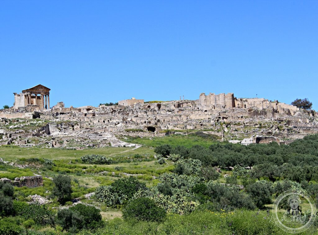
Dougga is the best-preserved Roman small town in North Africa: a complete provincial city draped over a hilltop at 571 metres, looking out across the fertile valley of the Oued Khalled. Capital of a Libyco-Punic state before Rome annexed Numidia, it kept its pre-Roman monuments alongside the Capitol, theatre and baths of the Roman centuries — a layering that earned it a place on the UNESCO World Heritage List in 1997.
At a glance
Unlike the great coastal ruins of Carthage or Leptis Magna, Dougga is a country town, and that is its value: UNESCO inscribed it for the exceptionally complete picture it gives of everyday life in a small provincial city of the Roman world. The urban fabric follows the slope of the hill rather than a rigid grid, with streets winding between temples, baths, markets and houses.
The site is also one of the most important epigraphic archives in Africa. More than two thousand inscriptions — Libyan, Punic, bilingual, Greek and above all Latin — have been recovered here, and they made a decisive contribution to the decipherment of the ancient Libyan language.
Key facts
- Location: a hilltop at 571 metres above the Oued Khalled valley, near Téboursouk in north-western Tunisia
- Before Rome: capital of an important Libyco-Punic state within the Numidian world
- Roman city: Thugga, a prosperous town of the province of Africa, at its height in the second and third centuries CE
- Signature monuments: the Capitol, the hillside theatre, the forum, several bath complexes and the pre-Roman Libyco-Punic mausoleum
- Epigraphy: over 2,000 inscriptions, key to deciphering the Libyan script
- Heritage status: UNESCO World Heritage Site, inscribed 1997 (ref. 794)
History
Thugga was already an old town when Rome arrived. Under the Numidian kings it was the capital of a Libyco-Punic state, and its most celebrated pre-Roman relic — a bilingual dedication in Punic and Libyan associated with the great mausoleum below the town — became one of the keys with which scholars unlocked the ancient Libyan script.
After the Roman annexation of Numidia the town grew into a prosperous provincial centre, its people gradually acquiring Roman civic status while older Numidian and Punic traditions persisted alongside. The monumental core visitors see today — Capitol, forum, theatre, baths, temples and triumphal arches — belongs mostly to the town’s second- and third-century prosperity, built on the grain wealth of the surrounding countryside, one of the breadbaskets of the Roman world.
The upper town was never built over by a later city, which is why so much survives: when antiquarians and archaeologists reached the hill in the nineteenth century, they found a Roman town asleep under soil and olive trees rather than quarried away. The Libyco-Punic mausoleum, damaged in the nineteenth century, was reconstructed between 1908 and 1910.
What you see
The Capitol is the emblem of the site — a temple on a high podium whose pedimented porch still stands to full height above the forum, one of the most photographed Roman buildings in Africa. Close by are the forum’s paving, the market, and the Square of the Winds, its pavement carved with a compass rose naming the twelve winds.
The theatre, set into the natural slope of the hill, preserves its semicircular seating and part of its stage building, and still commands a wide view over the valley. Downslope, the Libyco-Punic mausoleum — a rare surviving tower tomb of the pre-Roman Numidian world — anchors the older layer of the town’s history. Around these set pieces spread bath complexes, temples, triumphal arches, cisterns and whole streets of houses, enough to fill several unhurried hours.
Practical information
- Visiting: the site is large and spread over a hillside; allow at least half a day and wear sturdy shoes
- Season: spring and autumn are the kindest seasons; summer visits are best in the early morning
- Official information: see the Tunisian National Heritage Institute (INP) and UNESCO World Heritage Centre pages for current arrangements
Getting there
Dougga lies in the Béja Governorate of north-western Tunisia, about 110 km from Tunis by road; the nearest town is Téboursouk, a short drive from the site entrance. Most visitors come by hire car or on a day tour from Tunis, which can be combined with other Roman sites of the region. GPS: 36.4224, 9.2198.
Nearby
- Téboursouk — the market town nearest the ruins
- Bulla Regia — Roman town to the north-west, famous for its underground villas with mosaics still in place
- Testour — Andalusian-founded town on the road back towards Tunis
- Carthage — the great Punic and Roman metropolis on the coast beside Tunis, a UNESCO World Heritage Site
Sources
- UNESCO World Heritage Centre — Dougga / Thugga (ref. 794)
- ICOMOS nomination documentation, Dougga / Thugga
- Tunisian National Heritage Institute (INP)
Find it on the map
See this place and what’s around it →📷 Become a Cultural Heritage Online photographer
Share your photos of places: they stay published under your name as the author. The more they're seen, the more you get noticed — and soon a contest will reward the most appreciated photos.
Log in or sign up free to add a photo