
A vast protected landscape spanning seven contiguous parks across Alberta and British Columbia, celebrated for its dramatic peaks, glaciers, thermal springs, and exceptional fossil record.
At a glance
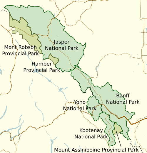
The Canadian Rocky Mountain Parks World Heritage Site encompasses four national parks—Banff, Jasper, Kootenay, and Yoho—alongside three British Columbia provincial parks: Hamber, Mount Assiniboine, and Mount Robson. Together they form one of North America’s most significant mountain ecosystems, protecting the headwaters of four major river systems: the North Saskatchewan, Athabasca, Columbia, and Fraser.
History
The Burgess Shale, a renowned paleontological site within the park system, was initially designated a World Heritage Site between 1980 and 1984. When the broader Canadian Rocky Mountain Parks received World Heritage status, the Burgess Shale became part of that larger designation, cementing the region’s global importance for both natural and scientific heritage.
What you see
The parks present the full drama of alpine geography: towering peaks, extensive glaciers, and crystalline lakes carved by ice age processes. Thermal springs emerge from the mountain foundation, most notably at Banff. The Burgess Shale formations expose half-a-billion-year-old marine fossils in extraordinary detail, offering a window into early animal evolution.
Cultural significance
This protected region stands as a global exemplar of mountain conservation and scientific research. The Burgess Shale remains one of the world’s most important sources for understanding Cambrian-era life. The parks represent an intact ecosystem supporting diverse flora and fauna adapted to high-altitude and alpine conditions.
Key facts
- Country: Canada (Alberta and British Columbia)
- Coordinates: 51.42°N, 116.48°W
- UNESCO World Heritage Site: Yes
- Comprises: Four national parks and three provincial parks
- Major rivers sourced: North Saskatchewan, Athabasca, Columbia, Fraser
Practical information & getting there
The parks are accessible via the Trans-Canada Highway and regional routes. The site spans the Alberta-British Columbia border in the heart of the Canadian Rockies. Each park maintains visitor facilities, trails, and seasonal access points. Check individual park websites for current conditions, permits, and visitor services before planning your visit.
Sources & resources
Find it on the map
See this place and what’s around it →📷 Become a Cultural Heritage Online photographer
Share your photos of places: they stay published under your name as the author. The more they're seen, the more you get noticed — and soon a contest will reward the most appreciated photos.
Log in or sign up free to add a photo