

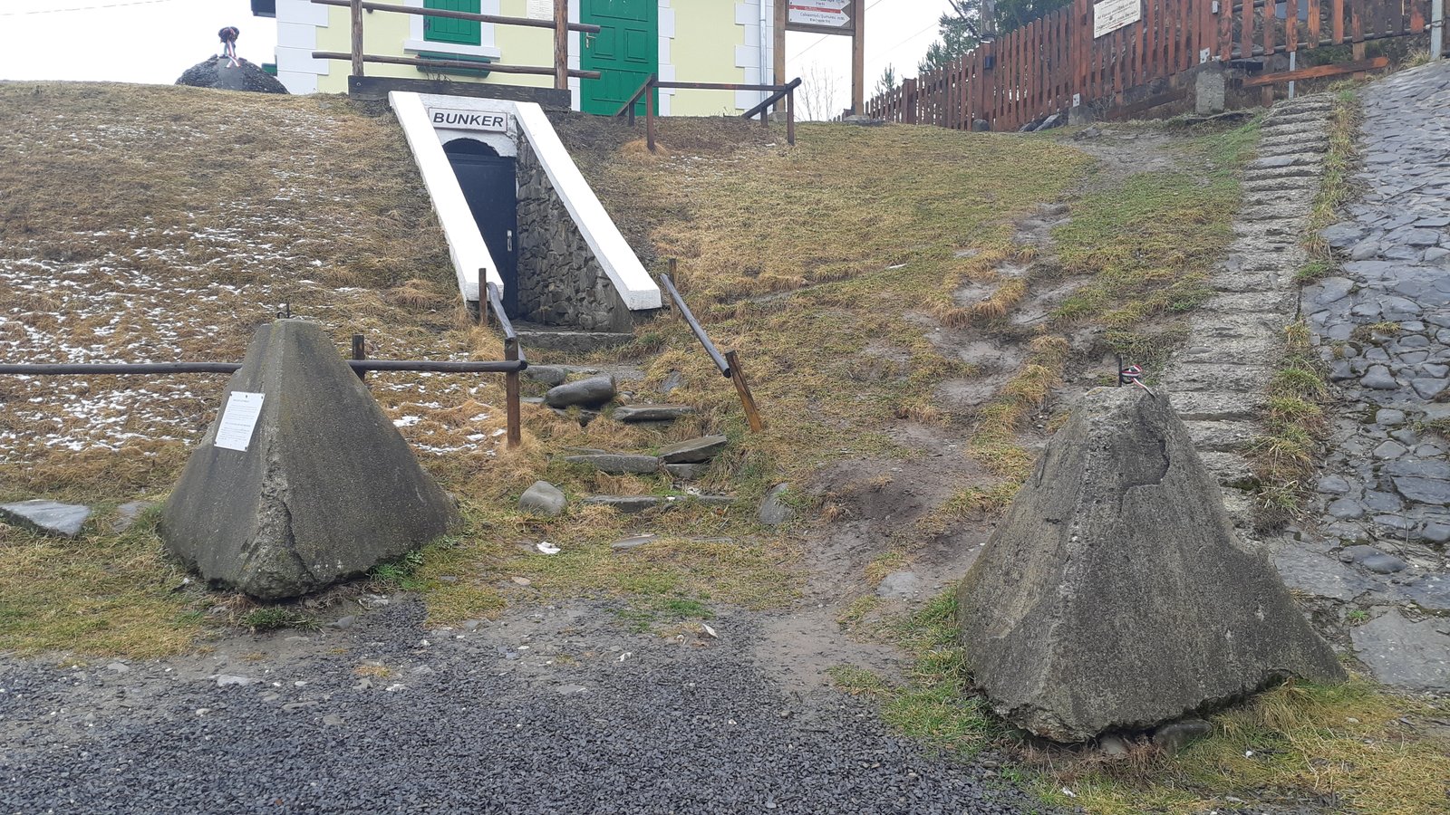
A narrow gorge where road, railway and border have run together for a thousand years, closed in the Second World War by concrete pillboxes and dragon’s teeth. A single hilltop above it is remembered locally as the site of the last Hungarian victory of the war — a claim the wider military record complicates without erasing.
At a glance
The Ghimeș pass carries the road and railway between Transylvania and Moldavia through a defile in the Eastern Carpathians. When the Second Vienna Award of August 1940 moved the Hungarian-Romanian border east, the pass became a frontier again, and the Hungarian Royal Army built one of its valley-closure positions here as part of the Árpád Line: a bunker dug into the hillside by the railway’s maintenance post known as Canton 30, and concrete dragon’s teeth blocking the gorge floor.
On 31 August 1944, eight days after Romania changed sides, Soviet troops took the hill above the pass, the 1,195-metre Bilibók-tető. A Hungarian counter-attack retook it the same day. Local memory calls it the last battle Hungary won in the Second World War; the operational record shows a war that had already moved somewhere else entirely.
Key facts
- Built: 1941–1944, part of the Hungarian Royal Army’s Árpád Line (“Árpád-vonal”), a field-fortification system laid out after the 1940 border change
- System scale: the line ran over 600 km through the Eastern Carpathians, roughly a third of it in present-day Romania, the rest in Ukraine and Slovakia
- Design: not a continuous wall but a chain of valley closures (“völgyzár”), each combining concrete pillboxes, earth-and-timber gun positions, anti-tank obstacles, minefields and barbed wire across a defensible pass
- At Ghimeș: a bunker beneath railway Canton 30 and dragon’s teeth across the gorge, guarding the road and rail corridor into Transylvania
- Battle of Bilibók-tető: 31 August 1944, 4th Székely Border Guard Regiment, counter-attack ordered by Colonel Gyula Böbl and led on the ground by warrant officer Béla Deáky
- Line abandoned: by 28 October 1944, following the collapse of the Hungarian front hundreds of kilometres away, on the plain west of Debrecen
- Coordinates: 46.6234° N, 26.0783° E (Ghimeș-Făget)
How it was built
The Árpád Line answered a problem the Maginot and Siegfried lines never had to solve: a border drawn along mountains, not plains, with neither the budget nor the years the Germans and French had spent on their own walls. The Hungarian command’s response, worked out in the doctrine years of 1939–40, was to stop trying to hold a continuous front and instead close the passes one by one — each valley a self-contained position, sited to use the terrain rather than fight it. It was a fraction of the cost per kilometre of the western examples, and it relied on the mountains themselves to do most of the work concrete did elsewhere.
Work accelerated sharply after the German defeat at Stalingrad in early 1943, when the strategic picture on the Eastern Front made a Soviet advance toward Hungary look less like a possibility and more like a schedule. At Ghimeș, the closure took the form ordinary along the line: a reinforced-concrete pillbox dug into the slope beside the railway’s Canton 30 maintenance post, its narrow embrasure covering the gorge, and a belt of dragon’s teeth set across the valley floor to stop armour where the rail bed and the road ran closest together. The garrison that manned it belonged to the border guard, not the regular army — light infantry trained to hold ground in terrain too steep for the tanks they were built to stop.
31 August 1944
Romania’s switch of sides on 23 August 1944 turned an ally’s border into a front line inside a week. By the end of the month, Soviet troops had pushed onto Bilibók-tető, the hill that commands the pass from above the bunker line. The 4th Székely Border Guard Regiment, holding the sector, was ordered to take it back. Colonel Gyula Böbl gave the order for a counter-attack; on the ground it was led by warrant officer Béla Deáky, and the position was retaken with a bayonet charge.
It is remembered locally as the last battle the Hungarian army won in the Second World War, and it may well have been. What it was not was decisive. The Árpád Line’s northern anchor at the Uzsok pass held without being broken through until 24 October 1944 — nearly two months later, and considerably longer than Bilibók-tető needed to matter. By then the war had already been lost somewhere else: Soviet forces of the 2nd Ukrainian Front had broken through on the Hungarian plain far to the west, and by 28 October, with the Debrecen operation concluded and encirclement a real threat, Hungarian troops abandoned the whole Eastern Carpathian line and withdrew — not because any single pass had fallen, but because holding the mountains no longer connected to anything worth holding them for.
Who tells it, and where the accounts diverge
The monument on Bilibók-tető was raised in 2009, not in 1944 — by the Vitézi Rend, a Hungarian order that preserves and commemorates the military history of the interwar and war years. Its stone marker carries reliefs of a Hungarian and a Russian soldier, and every year, on the last Saturday of August, a memorial mass is held there. The story it tells is complete in itself: a border position attacked, lost for a day, and won back with bayonets — the last Hungarian victory of the war.
The Hungarian army’s own operational chronicle, compiled after the war in the official military-historical reference literature, tells a story that sits uneasily next to the monument without contradicting it. Bilibók-tető was one skirmish in a five-week withdrawal that the Árpád Line, taken as a whole, did not lose in the mountains at all: its strongest sector held for weeks after Ghimeș, and the line was given up only once the war on the plains had made the Carpathians irrelevant. The victory on the hilltop was real. The frame around it — that it saved anything, or that the line’s fate turned on it — is not supported by the record of what happened next.
Neither version needs to be wrong for the other to be true. A regiment can win the fight in front of it and still be standing on ground the war has already passed by; the concrete at Ghimeș held exactly as designed, in a war that had stopped asking what the mountains could hold.
What you see today
- The bunker beneath Canton 30, its entrance and firing position still standing in the hillside beside the railway.
- Dragon’s teeth set in rows across the gorge floor, the anti-tank obstacle photographed alongside the bunker in 2022.
- The 2009 monument on Bilibók-tető, with its carved reliefs and the site of the annual late-August commemoration.
- The pass is working infrastructure, not a managed heritage site: road and rail traffic still run through it, and the fortifications sit alongside both, unsignposted and informal to visit.
Getting there
Ghimeș-Făget lies on the DN12A, the road connecting Comănești in Bacău County to Miercurea Ciuc in Harghita, and on the railway line that follows the same corridor. The pass and the border crossing sit at the commune’s western edge, where the gorge narrows between the two counties.
Nearby
- Miercurea Ciuc, the Székely Land’s largest town, west across the pass in Harghita County
- Comănești and the Trotuș valley, east in Bacău County, on the Moldavian side of the former border
Sources
- Lia-Maria Cioancă, «Árpád Fortification Line, as a Horthist Heritage of the Eastern Carpathians and Capitalization of the Tourism Potential of Ilvelor Valley from Bistrița-Năsăud County, Romania», International Conference Knowledge-Based Organization 26:3 (2020), DOI 10.2478/kbo-2020-0117 — construction pattern, casemate types, condition of the line at Romanian withdrawal.
- Magyarok a második világháborúban, Hungarian military-historical reference encyclopedia (Arcanum) — operational chronology of the Eastern Carpathian withdrawal, the Uzsok sector holding to 24 October 1944, and the Debrecen operation’s conclusion on 28 October.
- Székelyhon.ro, coverage of the annual commemoration at Bilibók-tető — battle date, units and commanders involved, and the 2009 monument.
- Wikipedia, Árpád Line — system-wide construction dates and scale. Used as a starting point and cross-checked against the sources above.
Find it on the map
See this place and what’s around it →Events here — now on & upcoming
- Anniversary: Romania Switches Sides, and the Front Reaches Ghimeș — August 23, 194423 Aug 2027See the event →
📷 Become a Cultural Heritage Online photographer
Share your photos of places: they stay published under your name as the author. The more they're seen, the more you get noticed — and soon a contest will reward the most appreciated photos.
Log in or sign up free to add a photo