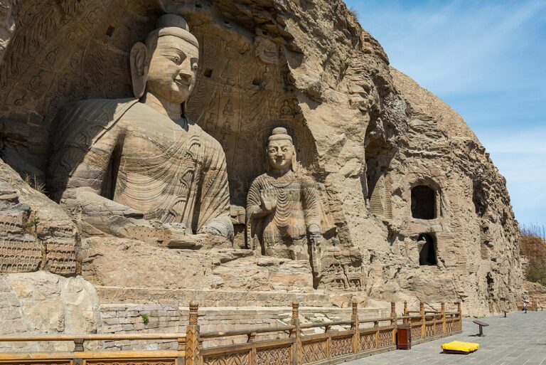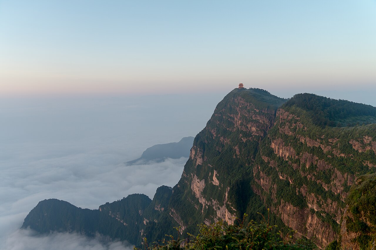
Mount Emei and the Leshan Giant Buddha were inscribed together as a UNESCO World Heritage Site in 1996. The Leshan Giant Buddha, carved between 713 and 803 CE from a cliff face at the confluence of the Min, Qingyi, and Dadu rivers in southern Sichuan, stands 71 metres tall — its shoulders span 28 metres and each foot is 8.5 metres long. The monk Haitong initiated the project in 713 CE, reportedly gouging out his own eyes to demonstrate sincerity to a skeptical magistrate who doubted the fundraising effort; construction continued for 90 years under successive prefectural governors after Haitong’s death. The drainage system that prevents weathering runs through the statue’s hair coils, ears, and robe folds and is invisible from standard viewing positions.
North to Chengdu’s Panda Country and the Sacred Taoist Peak 130–200 km north / 2–3 h by car or HSR
The two UNESCO sites closest to Mount Emei and Leshan both lie north of Chengdu, reachable from Leshan in two to three hours by road or high-speed rail via the provincial capital.
The Qingcheng Mountain and Dujiangyan Irrigation System was inscribed in 2000, covering two adjacent sites approximately 60 km northwest of Chengdu and 130 km north of Leshan by road. The Dujiangyan irrigation system is the older of the two elements: built between 256 and 251 BCE by the Qin State governor Li Bing, it divides the Min River into inner and outer channels using a fish-mouth levee and a bottle-neck pass cut through a mountain spur, distributing water to the Chengdu Plain without a dam. The system currently irrigates 668,000 hectares and has operated without interruption on its original hydraulic principles for over 2,270 years — the only ancient water management system in the world still in active agricultural use at this scale. Annual November dredging, prescribed in Li Bing’s original operating instructions, has been followed with only minor modifications throughout. Qingcheng Mountain, a forested peak adjacent to the irrigation works, is regarded as one of the founding locations of organised Taoism: the Zhang Dao Ling, credited with establishing the Celestial Masters school of Taoism, taught here in the 2nd century CE, and 36 Taoist temples remain on the mountain’s slopes. The ascent takes 3–4 hours on foot through dense subtropical vegetation; a cable car reaches the upper section. From Leshan: approximately 130 km north via the G93 expressway to Chengdu, then a further 60 km northwest, totalling 2–2.5 hours by car. By high-speed rail, Leshan to Chengdu takes 30 minutes, with a suburban rail connection to Dujiangyan taking a further 45 minutes.
The Sichuan Giant Panda Sanctuaries, inscribed in 2006 as a serial natural property, cover seven nature reserves and nine scenic areas across the Qionglai and Jiajin mountains of Sichuan Province. The inscribed area totals 924,500 hectares and encompasses the largest contiguous remaining habitat for the wild giant panda (Ailuropoda melanoleuca), with an estimated 30% of the global wild population resident within the boundaries. The Wolong National Nature Reserve, the largest single component, lies approximately 130 km west of Chengdu in Aba Prefecture, accessible via the S303 highway through steep mountain terrain — a 2.5-hour drive from Chengdu under normal conditions, longer in winter. For most visitors, the practical access point to the inscription is the Bifengxia Giant Panda Base near Ya’an, approximately 120 km from Chengdu (1.5 hours) and 90 km from Leshan (1.5 hours), where a captive-breeding population of over 80 pandas is maintained by the China Giant Panda Conservation and Research Center. Volunteer programmes requiring advance booking operate year-round. From Leshan, the Bifengxia base is the most time-efficient point of access, roughly 90 km on the G93 expressway, approximately 1.5 hours by car.
North and East: Jiuzhaigou Valley and the Dazu Rock Carvings 200–330 km / 2.5–5 h
Two further UNESCO inscriptions complete the circuit reachable from Mount Emei and Leshan within a single extended trip: one lies north in the mountains of Sichuan, the other east across the provincial border into Chongqing Municipality.
The Jiuzhaigou Valley Scenic and Historic Interest Area, inscribed in 1992 together with Huanglong as a serial property, occupies a deep valley in the Minshan mountains of northern Sichuan, approximately 330 km north of Chengdu. The valley covers 72,000 hectares between 1,996 and 4,764 metres elevation and contains 114 lakes, 17 waterfall groups, and 11 karst springs, all shaped by calcium carbonate-rich water depositing tufa and calcite on limestone bedrock. The name — Nine Village Valley — derives from nine Tibetan Baima villages historically established inside the valley, most of whose residents were relocated following UNESCO inscription and the 2017 earthquake. On 8 August 2017, a magnitude-7.0 earthquake caused landslides that significantly damaged the lake system; the valley reopened in September 2021 under a strict daily visitor quota. From Leshan, reaching Jiuzhaigou involves travelling north through Chengdu: approximately 330 km from Chengdu by road (5–6 hours by bus from Chadianzi station), or 45 minutes by domestic flight from Chengdu to Jiuzhaigou Huanglong Airport (JZH) at 3,448 metres — the highest commercial airport in Sichuan. The total journey from Leshan is 5–7 hours depending on mode. The visit requires a full day minimum; the daily ticket quota sells out weeks ahead during September–October peak foliage season.
The Dazu Rock Carvings, inscribed in 1999, are located in Dazu County approximately 160 km west of Chongqing city centre (2 hours by car or 2.5 hours by bus), and approximately 200 km east of Leshan by road across the Sichuan–Chongqing boundary. The carvings comprise over 50,000 sculptures across 75 sites, carved in sandstone cliffs during the Tang (618–907 CE), Five Dynasties (907–960 CE), and Song (960–1279 CE) dynasties. Unlike the earlier imperial cave projects at Longmen and Yungang — both commissioned under direct imperial patronage — the Dazu carvings were funded primarily by private individuals, Buddhist lay organisations, and local officials acting without central court direction. The most visited section, Baodingshan, was developed by the monk Zhao Zhifeng between approximately 1177 and 1249 CE as a planned devotional circuit of 31 scenes carved into a horseshoe-shaped valley. Among the most studied figures is the 31-metre-long Reclining Buddha at Parinirvana at Baodingshan, whose left hand is positioned with the index finger pointing toward a disciple holding the Record of Good Deeds. The carvings also display a syncretic combination of Buddhist, Taoist, and Confucian iconography unusual in Chinese Buddhist cave art — a deliberate theological programme characteristic of the Song-dynasty popular religious fusion. From Leshan: approximately 200 km east via the G93 and G50 expressways, 2.5–3 hours by car; by high-speed rail, Leshan to Chongqing North takes 1.5 hours, then 2 hours by car or bus to Dazu, totalling approximately 3.5 hours.
Practical information
Reaching Mount Emei and Leshan: the base city is Leshan, 160 km south of Chengdu and connected by high-speed rail (30 minutes, several trains hourly). From Leshan railway station, buses and taxis reach the Leshan Giant Buddha wharf (3 km) or Mount Emei’s base (30 km, 40 minutes). Both sites can be done in a single day from Chengdu as a long day trip, though an overnight in Leshan or at the Emei mountain base (Baoguo Temple area) allows more time. The Mount Emei ascent to the Golden Summit takes 2 days on foot via the 50-km path, or a half-day using the two cable car stages (Leidongping to Jinding). The golden-coated Samantabhadra statue at the summit stands at 3,077 metres; temperatures there can drop below 0°C year-round and mist is frequent, obscuring the summit for hours at a time.
Best season: March–June for mountain flowers and clear summit views; September–November for reduced summer crowds. The Leshan Giant Buddha is accessible year-round; a boat tour on the river below gives the only full-body view of the sculpture, since the cliff-side stairway descends only to foot level. Macaques (Macaca thibetana) inhabit the cable car route on Emei and are habituated to tourists — they take food from bags and hands and should not be fed or approached closely.
Combined circuit logistics: a 4-day Sichuan circuit from Chengdu can cover Dujiangyan and Qingcheng Mountain (Day 1), drive to Bifengxia panda base near Ya’an (Day 2), continue to Mount Emei and Leshan (Day 3), then return to Chengdu by HSR (Day 4). Dazu requires a separate leg east into Chongqing. Jiuzhaigou is a standalone trip of 2–3 days from Chengdu and should not be combined with the southern sites on the same day.
Frequently Asked Questions
How was the Leshan Giant Buddha’s drainage system designed and does it still work?
The drainage system built into the Leshan Giant Buddha during its construction between 713 and 803 CE consists of a network of channels cut into the sandstone of the cliff face and concealed within the sculpture’s decorative elements. Water is channelled through the hair coils on the Buddha’s head, which are not solid but contain hidden outlets; through the ears, which have drainage channels cut into them; and through the chest area and folds of the robe, where additional channels carry surface water away from the cliff face. The system was designed to prevent water from pooling in carved recesses, which would accelerate freeze-thaw weathering of the sandstone. The drainage channels are not visible from the standard viewing platforms or from the boat tour below; they are documented in engineering surveys conducted during conservation assessments. The system has functioned with maintenance for over 1,200 years, though repeated conservation campaigns have been necessary — the most recent major effort began in 2019 when the statue’s chest and abdomen area was found to have developed cracks in the sandstone that allowed water infiltration. That restoration project concluded in 2021. The main threats to the sculpture’s long-term preservation are increased air humidity from the surrounding river confluence, acid rain (the Leshan area has historically high industrial pollution from nearby Yibin and Zigong), and biological growth of algae and moss on the stone surface. The Buddha’s face has been altered by at least two major restoration campaigns in the 20th century, which replaced eroded sandstone features with cement infill — a practice now considered problematic by conservation standards and not repeated in recent work.
What is the role of Tibetan Buddhism on Mount Emei and how does it differ from the Buddhist sites nearby?
Mount Emei is traditionally associated with Samantabhadra Bodhisattva (Puxian in Chinese), who according to Buddhist scripture is said to have preached from atop an elephant on the mountain — the name Emei is interpreted in some traditions as referring to the mountain’s silhouette resembling an eyebrow or an elephant tusk. The first documented Buddhist structures on the mountain date to the Eastern Han dynasty (25–220 CE), making this one of the earliest Buddhist sacred mountains in China. At the peak of the mountain’s religious prominence, over 100 monasteries occupied the slopes; 26 monasteries survive today and remain active religious institutions, not solely tourist sites. The tradition practised on Emei is primarily Han Chinese Buddhism (also called Mahayana Buddhism in the Chinese form), not Tibetan Buddhism in the doctrinal sense — despite the geographic proximity to Tibetan cultural zones. The Leshan Giant Buddha, by contrast, belongs to the Pure Land and esoteric Buddhist traditions common to Tang-dynasty (618–907 CE) imperial patronage of cave and cliff sculpture. The Dazu Rock Carvings 200 km east represent a later, syncretic development that deliberately combined Buddhist iconography with Taoist and Confucian figures in a single sculptural programme — theologically distinct from the earlier sacred mountain tradition at Emei. Mount Emei’s contemporary visitor base includes both religious pilgrims following the traditional 50-km circumambulation route past all 26 monasteries and secular tourists using the cable car for summit access.
Why did Li Bing build Dujiangyan without a dam and why has no dam been built since?
The Dujiangyan irrigation system works without a dam because Li Bing’s design exploits the natural hydraulics of the Min River rather than blocking and storing water. The fish-mouth levee at the head of the system splits the river into an inner channel (carrying approximately 40% of flow in the dry season, 60% in the flood season due to the centrifugal dynamics of the split) and an outer channel. A sand-discharge sluice, the Feishayan, allows excess water and silt to overflow from the inner channel into the outer during high flow. A bottle-neck pass cut through a mountain spur, the Baopingkou, regulates flow entering the plain and creates a natural pressure ceiling during floods. The system is self-regulating: no operator intervention is required to maintain the proportion of water between channels during normal conditions. A dam would have solved the flood problem but would have caused downstream silt accumulation, would have required mechanical management, and would have flooded the upriver valley including the city of Guanxian. From a civil engineering perspective, the dam-free design also proved more resilient: the 2008 Sichuan earthquake (magnitude 7.9), which caused catastrophic damage throughout the Min River valley including to Dujiangyan city itself, did not destroy the ancient water management works. Proposals to build a dam upstream on the Min for hydroelectric purposes have been made repeatedly in the 20th and 21st centuries and have consistently been blocked or modified partly on the grounds of potential impact on the Dujiangyan system’s hydraulic regime, which is protected as a UNESCO-inscribed monument.
Sources
- S1 — UNESCO World Heritage Centre — Mount Emei Scenic Area, including Leshan Giant Buddha Scenic Area (Ref. 779) — https://web.archive.org/web/20230601000000/https://whc.unesco.org/en/list/779/
- S2 — Leshan Giant Buddha Scenic Area Management Committee — https://whc.unesco.org/en/list/779/
- S3 — Kuhn, Dieter. <em>The Age of Confucian Rule: The Song Transformation of China</em>. Harvard University Press, 2009. ISBN: 978-0-674-03661-1.
Spotted an error? Write to editorial@culturalheritageonline.com and we correct it the same day.