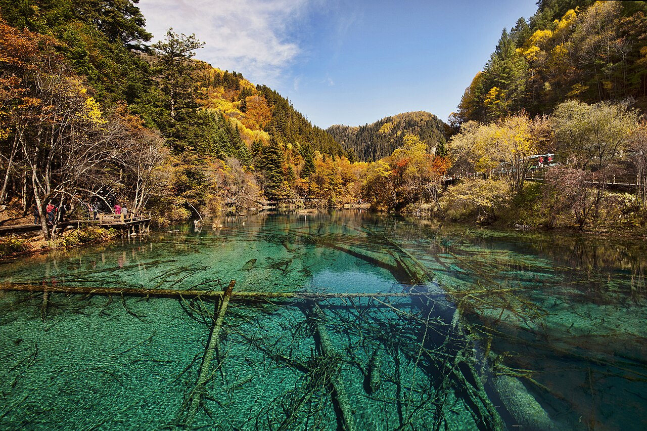
Jiuzhaigou Valley in northern Sichuan Province was inscribed as a UNESCO World Heritage Site in 1992. The protected area covers 72,000 hectares at altitudes between 1,996 and 4,764 metres, enclosing 114 lakes, 17 groups of waterfalls, 5 tufa-calcite shoals, and 11 karst springs. The valley takes its name — Nine Stockade Valley — from the nine Tibetan villages historically established within it; on 8 August 2017, a 7.0-magnitude earthquake caused extensive damage to the lake system and closed the valley to tourists for four years, reopening under a strict daily visitor quota in September 2021.
Sichuan’s Mountain Core: Huanglong and the UNESCO Serial Inscription 110 km south / 3 h by car
Jiuzhaigou and its nearest UNESCO neighbour are not simply adjacent properties. They share a single inscription.
The Jiuzhaigou Valley Scenic and Historic Interest Area and the Huanglong Scenic and Historic Interest Area were inscribed together in 1992 as a serial property — two sites treated as a single nomination on the basis of their shared geological processes and ecosystem. Both are karst landscapes shaped by calcium carbonate-rich water depositing tufa and calcite as it flows across limestone bedrock, producing lake colours that range from turquoise to emerald to pale jade depending on the depth, the angle of light, and the concentration of mineral sediment. At Huanglong, the primary feature is a 3.6-km calcite-deposited valley floor at 3,500 metres elevation, known for its terraced pools — 3,400 of them, in shades of yellow, green, and blue, the colours created by the varying thickness of the calcite crust beneath the water. The largest pool, Caocuo, is several hundred metres across.
Huanglong sits at a higher elevation than Jiuzhaigou’s valley floor and is more physically demanding: the ascent to the upper pools at 3,800 metres involves a 3-hour hike (or a cable car to 3,500 m, then 45 minutes on foot). Altitude sickness is a genuine concern — portable oxygen canisters are sold at the entrance and are not merely a tourist concession. The site receives approximately 2 million visitors per year, far fewer than Jiuzhaigou. Huanglong’s main scenic area is closed October to April due to snow; its peak season is July–September. Distance from Jiuzhaigou: approximately 110 km south via the S301 provincial highway through the Minshan mountains, 3 hours by car or tourist bus. A direct paved road connects the two sites; buses run from the Jiuzhaigou entrance to Huanglong in peak season.
Combined visit logistics: Jiuzhaigou requires a full day minimum under the current visitor quota system (tickets are released online, daily limit is approximately 5,000 visitors in the recovery phase since 2021, subject to change). Huanglong requires a half-day for the cable-car-assisted version, a full day if ascending on foot. A two-day stay in the Jiuzhaigou resort zone — hotels concentrated around the valley entrance at Zhangzha township — allows both in sequence: Jiuzhaigou Day 1, drive to Huanglong Day 2. The airport at Jiuzhaigou Huanglong Airport (JZH) serves both sites; it sits between the two at 3,448 metres elevation, the highest commercial airport in Sichuan.
South toward Chengdu: Three UNESCO Properties within a Sichuan Circuit 230–330 km south / 3–5 h by car or bus
Returning south from Jiuzhaigou toward the Sichuan capital brings three further UNESCO World Heritage Sites within a single regional arc — each requiring at least a half-day and representing a completely different heritage type from the mountain landscape of the north.
The Sichuan Giant Panda Sanctuaries, inscribed in 2006 as a natural serial property covering seven nature reserves and nine scenic areas across Sichuan Province, include the Wolong National Nature Reserve approximately 130 km west of Chengdu. The inscription recognises the Qionglai and Jiajin mountains as the largest remaining contiguous habitat for the wild giant panda (Ailuropoda melanoleuca), with an estimated 30% of the world’s remaining wild population within the inscribed area. The base for visitor access is the Bifengxia Giant Panda Base near Ya’an, approximately 120 km from Chengdu, where captive-breeding programmes maintain a population of over 80 pandas. Volunteer programmes allowing extended supervised contact with the animals operate year-round and require advance booking. Travel from Jiuzhaigou: approximately 300 km south to the Bifengxia base, 5 hours by road or 4 hours bus from Chengdu after the 5-hour journey from Jiuzhaigou.
The Mount Emei Scenic Area and Leshan Giant Buddha Scenic Area form a serial UNESCO inscription added in 1996. Mount Emei (3,099 metres), 150 km southwest of Chengdu, is one of the four sacred Buddhist mountains of China; the first Buddhist temple was established here in the 1st century CE, and at its peak the mountain housed more than 100 monasteries, of which 26 survive today. The golden summit statue of Samantabhadra Bodhisattva, 8 metres tall and installed in 1987, replaced an older structure destroyed by fire. The 50-km ascent route — walkable in 2 days on foot, or shortened by cable car to the Jinding (Golden Summit) at 3,077 metres — passes through mixed subtropical and subalpine forest zones that the mountain’s elevation range supports. The Leshan Giant Buddha (Dafo), 30 km from Mount Emei’s base, was carved between 713 and 803 CE from a cliff face at the confluence of three rivers. It stands 71 metres tall — the torso alone is 14.7 metres wide — making it the largest pre-modern stone Buddha in the world. The statue was commissioned by a Buddhist monk, Haitong, who believed its presence would calm the dangerous river currents at the confluence; historical records indicate that rock removed during carving was deposited in the water and did alter the hydraulics. From Jiuzhaigou: 300 km south via Chengdu, 5–6 hours total transit; or from Chengdu directly, 2 hours by train to Leshan.
The Qingcheng Mountain and Dujiangyan Irrigation System UNESCO inscription (2000) encompasses two adjacent sites 60 km northwest of Chengdu, approximately 230 km south of Jiuzhaigou. The Dujiangyan irrigation system was built between 256 and 251 BCE by Li Bing, the governor of Shu under the Qin State, and remains in operational use today — the only ancient irrigation system in the world still functioning on its original hydraulic principles. It diverts the Min River into an inner and outer channel using a fish-mouth embankment and a bottle-neck spillway channel cut through a mountain, distributing water to the Chengdu Plain without a dam and without silt accumulation. The system transformed a flood-prone plain into the “Land of Abundance” (Tianfu Zhidi) that fed the Qin State’s military campaigns. Qingcheng Mountain, adjacent to the irrigation system, is one of the cradles of Taoism: the Zhang Dao Ling, considered the founding figure of organised Taoist religion, taught here in the 2nd century CE. Thirty-six Taoist temples remain on the mountain’s slopes. From Jiuzhaigou by road: approximately 230 km via the G5 expressway, 3.5 hours; a direct shuttle bus from the Jiuzhaigou area runs to Chengdu, from which Qingcheng Mountain is 45 minutes by HSR.
Practical information
Reaching Jiuzhaigou: Jiuzhaigou Huanglong Airport (JZH) operates daily flights from Chengdu Shuangliu International Airport (45 minutes) and seasonal direct flights from Beijing, Shanghai, and Xi’an. Mountain weather at 3,448 metres means frequent afternoon cloud cover and occasional wind holds; build a day’s flexibility into your schedule. Alternatively, the 300 km road journey from Chengdu takes 5–6 hours by bus (several daily departures from Chadianzi bus station); the route follows the Min River north through alpine gorge scenery. A new high-speed rail line connecting Chengdu to Jiuzhaigou is under construction; completion is expected in the mid-2020s.
Best season: May–June and September–October. Autumn colour in Jiuzhaigou valley (mid-October) is the single most photographed season; daily visitor quotas sell out online weeks in advance. Summer (July–August) is the wettest period. Winter (November–March) brings snow above 2,500 metres and dramatically reduced visitor numbers; some guesthouses and shuttle buses in the valley close December–February.
Visitor quota: Since reopening in 2021, Jiuzhaigou operates under a strict daily ticket limit. Book through the official website (cnta.gov.cn linked ticketing platforms) at least 3 days ahead during peak season, or through a licensed local travel agency. The 2017 earthquake damaged or destroyed 10% of the lakes and several major waterfalls; the restoration plan is ongoing, and some sections remain closed to protect recovery.
Frequently Asked Questions
What caused the distinctive lake colours at Jiuzhaigou and how did the 2017 earthquake change them?
The lakes of Jiuzhaigou derive their colour from a combination of dissolved calcium carbonate and suspended calcite particles in the water, along with the growth of algae and aquatic mosses that colonise the tufa and travertine platforms beneath the surface. Different lakes register different colours — turquoise, jade green, cobalt blue, pale yellow — because the proportions of these elements vary with water depth, mineral concentration, and the angle of sunlight at different times of day and year. The Five Flower Lake (Wuhuahai), one of the most photographed, displays three or four distinct colour zones visible simultaneously from the viewing platform above it, caused by the gradient from shallow shoreline to deeper centre and the varying thickness of the algae mat. The 8 August 2017 earthquake (magnitude 7.0, epicentre within the scenic area) caused mass landslides that sent tonnes of sediment into the lake system. Zhechewa Lake (Pearl Beach) suffered partial collapse of its tufa embankment; the waterfall below it was dramatically reshaped. Nuorilang Waterfall, the widest in China at 320 metres, lost approximately 40% of its eastern section to rockfall. In the years since the earthquake, sedimentation has gradually changed the colour balance of several lakes — some formerly turquoise pools shifted toward olive green as suspended sediment levels remained elevated. The recovery is measurable but not complete; park management has used drone monitoring since 2019 to track lake-by-lake colour change as an index of ecosystem recovery.
What is the significance of the Tibetan villages in Jiuzhaigou and are they still inhabited?
The name Jiuzhaigou translates directly as Nine Stockade Gully or Nine Village Valley, referring to the nine Tibetan villages historically present within the valley: Shuzheng, Heye, Zechawa, Rize, Panya, Jianpan, Yala, Yongzha, and Guaerzhai. These communities — belonging to the Baima Tibetan ethnic group, a distinct subgroup recognised separately from central Tibetan culture — were established in the valley at a date that local oral tradition places in the Tang Dynasty (618–907 CE), though documentary evidence is more limited. The inhabitants practised a combination of subsistence farming, animal husbandry, and seasonal hunting in the surrounding forests. After the valley was designated a national park in 1978 and UNESCO inscribed it in 1992, the relationship between the resident communities and the park administration became contentious. By the early 2000s, most residents had been relocated to the resort township of Zhangzha outside the valley, with compensation provided by the local government. A small number of residents, particularly in Shuzheng village, remained within the park boundaries and were permitted to operate small guesthouses and handicraft stalls as a compromise between heritage preservation and community rights. After the 2017 earthquake, the remaining in-valley residents were evacuated and have not fully returned. The Baima Tibetan cultural presence in the valley is now maintained primarily through performances, traditional dress worn by staff, and annual festivals rather than through a living residential community.
How does the Dujiangyan irrigation system work and why is it still in use after 2,200 years?
The Dujiangyan irrigation system was built under the direction of Li Bing, the Qin-appointed governor of the Shu region (present-day Sichuan), beginning around 256 BCE. The fundamental engineering problem was the Min River: in spring and early summer, snowmelt from the Qinghai-Tibet Plateau sent flood volumes down the Min that destroyed settlements and crops on the Chengdu Plain; in summer and autumn, lower flows left the same plain dry. Li Bing’s solution was to divide the river rather than dam it. The fish-mouth levee (Yuzui) — named for its shape — splits the Min into an inner channel (Neijian, carrying roughly 40% of the flow toward the irrigation system) and an outer channel (Waijian, carrying the majority flow past the city of Guanxian). A sand-discharge sluice (Feishayan) allows flood water and silt to spill from the inner channel into the outer when the inner channel’s flow exceeds the irrigation system’s needs, preventing sediment accumulation. A bottle-neck pass (Baopingkou), cut through a mountain spur, regulates the flow entering the plain and creates a back-pressure that prevents flooding during peak flow. The elegance of the system is that it requires no dam, no moving parts, and no external energy source: it operates purely on river hydraulics and the geometry of the channels. Silt management was provided by an annual dredging protocol, performed each November when the Outer River flow was temporarily diverted, that Li Bing encoded in the operating instructions as the standard maintenance regime — a procedure followed with only minor modifications for 2,200 years. The system currently irrigates 668,000 hectares of agricultural land in the Chengdu Plain.
Sources
- S1 — UNESCO World Heritage Centre — Jiuzhaigou Valley Scenic and Historic Interest Area (Ref. 637) — https://web.archive.org/web/20230601000000/https://whc.unesco.org/en/list/637/
- S2 — Jiuzhaigou National Nature Reserve Administration — https://whc.unesco.org/en/list/637/
- S3 — Seidensticker, John. <em>Riding the Tiger: Tiger Conservation in Human-Dominated Landscapes</em>. Cambridge University Press, 1999. ISBN: 978-0-521-64835-6.
Spotted an error? Write to editorial@culturalheritageonline.com and we correct it the same day.