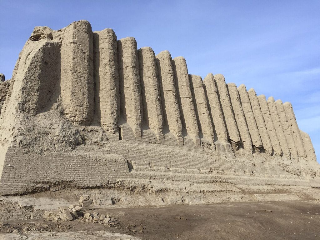
State Historical and Cultural Park “Ancient Merv” — inscribed by UNESCO in 1999 — encompasses the archaeological complex of ancient Merv (Parthian and Sassanid Marv, Arabic Marw, medieval Merv) in Mary Province, southeastern Turkmenistan, on the Murghab River oasis in the Karakum Desert: four successively established fortified cities spanning approximately 2,500 years of continuous occupation (from the Achaemenid period, 6th century BCE, to the Timurid period, 15th century CE) that made Merv the largest city in the world for a brief period in the 12th century CE and one of the great oasis capitals of the Silk Road.
The four cities of Merv: Erk Kala, Gyaur Kala, Sultan Kala, and the Silk Road metropolis Erk Kala (Achaemenid-Parthian citadel) · Gyaur Kala (Sassanid city, 8 km perimeter) · Sultan Kala (Seljuk capital, 12th century) · Kyz Kala (Sassanid fortress) — within the inscription
The archaeological complex of Ancient Merv occupies an area of approximately 50 km² on the left bank of the Murghab River, encompassing the physical remains of four major city phases that were built successively on overlapping sites as the settlement centre shifted over the centuries. Erk Kala (the “citadel of the Achaemenid period,” approximately 7th–6th century BCE, an oval earthen fortification of approximately 12 hectares occupied as the administrative centre of the Achaemenid satrapy of Margiana) is the oldest visible structure at the site: an earthen rampart of approximately 12–15 metres height, preserved in its oval outline, representing the earliest phase of organised urban settlement at the Merv oasis. Gyaur Kala (“fortress of the infidels,” the dismissive Islamic-period name for the pre-Islamic city) is the Parthian and Sassanid-period city of Marv: a large roughly square fortified area of approximately 4 × 4 km (approximately 16 km² of enclosed urban area, one of the largest Sassanid cities), surrounded by a perimeter wall of mud brick with rectangular towers at approximately 35-metre intervals, enclosing a complex of administrative buildings, a large Buddhist monastery (the Gyaur Kala stupa, one of the westernmost Buddhist monuments in Central Asia, dating to approximately 3rd–7th century CE and reflecting the presence of Buddhist communities in the Merv oasis during the period of its greatest cultural diversity), temples, and urban residential quarters. The Kyz Kala complexes (Greater and Lesser Kyz Kala, “Fortress of the Girls”) — two residential or administrative buildings of the Sassanid or early Islamic period (6th–8th century CE) with their distinctive corrugated mud-brick exterior walls (vertical fluted buttresses producing the characteristic rippling surface visible from the approach road) — are the most visually striking structures at Merv: the corrugated wall treatment, unique to this site and its region, has been interpreted as both a structural device (increasing the wall’s resistance to lateral pressure) and an aesthetic choice (the pattern of light and shadow on the corrugated surface producing a distinctive visual effect). Sultan Kala (“City of the Sultan,” the Seljuk capital, 11th–13th century CE) is the largest walled area at Merv: a fortified urban complex of approximately 8 × 4 km built by the Great Seljuk sultans after the Arab Abbasid conquest (651 CE) and the subsequent Seljuk capture of Merv (1037 CE), which made the city the capital of the Great Seljuk Empire under Sultan Sanjar (reign 1118–1157 CE). At its peak in the 12th century CE, Merv (as Sultan Kala) was estimated by medieval Arabic geographers (including Yaqut al-Hamawi) to be one of the largest and most populous cities in the Islamic world, with a population possibly exceeding 200,000 — the claim that it was “the largest city in the world” in the 12th century CE is supported by these literary sources, though archaeological confirmation of the full population is impossible.
The most significant surviving monument at Sultan Kala is the Mausoleum of Sultan Sanjar (completed approximately 1157 CE, the tomb of the last Great Seljuk sultan, built during his own lifetime as a dynastic monument): a square base of approximately 27 × 27 metres supporting a double-shell dome of approximately 17 metres internal diameter, the entire exterior originally covered in turquoise faience tile (the surviving dome retains enough of the turquoise tile to give an impression of the original chromatic effect). The Sanjar mausoleum represents the mature Seljuk architectural tradition — a mausoleum form (square plan, domed chamber) that influenced the subsequent development of Islamic funerary architecture across the Islamic world from Anatolia to Central Asia and South Asia. The Mongol conquest and destruction of Merv (1221 CE, by the forces of Tolui Khan, son of Genghis Khan) was one of the most catastrophic events in medieval Central Asian history: medieval Persian chronicles describe a population of approximately 700,000–1,300,000 killed (figures certainly exaggerated but indicating a destruction of extraordinary scale), the irrigation system of the Murghab oasis systematically demolished (breaking the dams that maintained the agricultural basis of the oasis), and the city itself burned and pulled down to prevent reoccupation. The destruction of Merv in 1221 CE effectively ended its role as a major urban centre; the subsequent Ilkhanid and Timurid reoccupations of the site were smaller-scale, and the modern city of Mary (population approximately 85,000, administrative centre of Mary Province) was established approximately 30 km from the ancient site.
Practical information
The Ancient Merv State Historical and Cultural Park is located approximately 30 km east of the modern city of Mary (formerly Merv, administrative centre of Mary Province), accessible from Mary by taxi (approximately 30–40 minutes) or by tour from Ashgabat (the Turkmenistan capital, approximately 350 km northwest). Visiting Turkmenistan requires a visa (a tourist visa is obtainable but requires advance arrangement, typically through a Turkmenistan-registered tour operator; an e-visa system has been introduced but requirements change regularly — confirm current requirements before planning). The site is technically open to independent visitors with a visa but is practically easier to visit on an organised tour from Ashgabat or from Mary. The nearest international airports are Ashgabat International Airport (ASB, direct flights from Istanbul, Frankfurt, Moscow, Minsk, Beijing) and Mary Airport (MYP, domestic flights from Ashgabat, approximately 45 minutes). The site museum at Merv and the National Museum of Turkmenistan in Ashgabat hold the principal finds. Allow a full day for the Merv site (driving between the major structures across the 50 km² area is required; walking between all sites is not practical). Best season: March–May and September–November (the Karakum Desert is extremely hot in summer, with July temperatures exceeding 45°C).
Frequently Asked Questions
Why was Merv considered one of the largest cities in the world in the 12th century?
Merv’s claim to be among the largest cities in the world in the 12th century CE rests on the testimony of medieval Arabic and Persian geographers, particularly the comprehensive geographical dictionary of Yaqut al-Hamawi (compiled 1224 CE, based on travels and readings from approximately 1215–1224 CE) which describes Merv as “the mother of the world” and “the greatest and most famous of the cities of Khorasan” — Khorasan being the historical region of northeastern Iran, western Afghanistan, and the Amu Darya basin that was the intellectual and economic heartland of the eastern Islamic world in the 10th–12th centuries CE. The archaeological evidence from Sultan Kala is consistent with a large city population: the enclosed area of approximately 8 × 4 km (comparable to the largest medieval Islamic cities) and the extensive suburban agricultural landscape of the Murghab oasis (capable of supporting a large urban population through intensive irrigation agriculture) support the claim of a significant population, though the specific figures given in medieval sources (typically 200,000–500,000 within the city walls, 700,000–1,300,000 including the surrounding agricultural population) are likely at the upper end of what the physical evidence can support. Merv’s size and population derived from its position at the confluence of the great trade routes of Central Asia: the city was the principal market at the eastern end of the Khorasan Road (connecting the Iranian plateau to the Transoxiana region east of the Amu Darya), the departure point for the trans-desert route to Samarkand and Bukhara, and the agricultural centre of the Murghab oasis — the largest reliable water source in the eastern Karakum Desert. The combination of trade revenues, agricultural surplus from the irrigated oasis, and Seljuk imperial patronage (the Great Seljuk sultans used Merv as one of their principal capitals and invested in its buildings, water supply, and fortifications) produced the medieval population concentration that made it a significant entry in the “world’s largest city” competition for the 12th century CE — a period when it may have rivalled or exceeded Cairo, Baghdad, and Constantinople in population.
What was the Silk Road and how did Merv function as a node in the network?
The Silk Road — a name coined by the German geographer Ferdinand von Richthofen in 1877 CE to describe the overland trade routes connecting China to the Mediterranean world — was less a single road than a network of caravan routes, river corridors, and oasis staging points connecting the civilisations of China, Central Asia, Iran, the Middle East, and the Mediterranean from approximately 2nd century BCE (the Han Dynasty’s opening of the Gansu corridor to Central Asia) to the 15th century CE (when the Ottoman conquest of Constantinople and the Portuguese development of the sea route around Africa reduced the profitability of overland Central Asian trade). Merv functioned as a major node in this network as the junction point where the primary east-west route across the Iranian plateau (from the Caspian to the Amu Darya crossing and thence to Bukhara and Samarkand) met the north-south routes connecting Khorasan to the Caucasus (via the Caspian coast) and to India (via the Hindu Kush passes and the Indus valley). The practical significance of Merv’s position was water: in the Karakum Desert, the Murghab River oasis was the only reliable source of water for a large caravan for approximately 500 km in any direction; caravans crossing the desert from either direction had to pass through Merv to water their animals, stock their food, and rest their travellers. This geographic bottleneck made Merv’s rulers wealthy from transit tolls and market fees regardless of what goods were being traded. The actual goods traded through Merv (silk, spices, glass, metals, slaves, horses — the famous Ferghana horses of Central Asia were the premium commodity that motivated the Han Emperor Wu’s campaign to open the Silk Road in the 2nd century BCE) were stored in the hans and caravanserais of the city’s commercial zone, exchanged and repackaged for the next leg of the journey, and assessed for customs duties by the city’s commercial administration. The intellectual exchange that accompanied the trade — Buddhist monks travelling from India to China, Nestorian Christian missionaries, Islamic scholars, mathematicians and astronomers from the great centres of learning at Merv — was in many respects more significant for world history than the material trade itself.
What was the impact of the Mongol destruction of Merv in 1221 CE?
The Mongol destruction of Merv in February 1221 CE was carried out by the forces of Tolui Khan (youngest son of Genghis Khan) following the resistance and attempted negotiation of the city’s population after the Khwarazmian sultan Muhammad II’s defeat by Genghis Khan’s main army at Samarkand and the collapse of Khwarazmian military resistance throughout Khorasan. The medieval Persian chronicles (particularly the detailed account in Juvayni’s “Tarikh-i Jahangushay,” written approximately 1260 CE) describe the following sequence: after a brief siege and a negotiated surrender (in which the city’s population was promised safety in exchange for submission), the Mongol commanders reneged on the surrender terms, assembled the entire population of the city on the plain outside the walls, and systematically killed them over several days. The destruction of the urban infrastructure — the demolition of buildings, the breaking of the Murghab River dams that maintained the irrigation system, and the killing of the skilled craftsmen, scholars, and administrators who maintained the complex oasis economy — was thorough enough to eliminate Merv as a functioning city. The Mongol general Tolui’s campaign through Khorasan (simultaneously destroying Merv, Nishapur, Herat, and the surrounding towns) reduced the population of what had been the most economically and intellectually productive region of the Islamic world by an amount estimated by modern historians at approximately 50–90% in the worst-affected areas, permanently altering the settlement pattern, the irrigation infrastructure, and the intellectual life of the region. The destruction of the Merv oasis irrigation system (which required constant maintenance of dam walls and channel systems to remain productive) was perhaps the most lasting consequence: the re-establishment of the Murghab irrigation system after the Mongol period was never complete, and the agricultural potential of the oasis never fully recovered to its pre-Mongol level, reducing the city that replaced Merv (the modern Mary, established approximately 30 km from the ancient site in the 19th century under Russian administration) to a much smaller scale than the medieval Merv had achieved.
EXCERPT: State Historical and Cultural Park Ancient Merv (UNESCO 1999) — the Silk Road oasis capital of four successive cities (Achaemenid to Timurid, 6th century BCE–15th century CE) in Mary Province, Turkmenistan, where Sultan Sanjar’s 1157 CE mausoleum marks the Great Seljuk era of maximum prosperity, destroyed by the Mongols in 1221 CE.
META: UNESCO World Heritage Sites near Ancient Merv Turkmenistan: Kunya-Urgench 750 km northwest, Parthian Fortresses of Nisa 350 km northwest — Turkmenistan Silk Road circuit from the oasis Seljuk capital to the Khwarazmian citadel and the Parthian royal fortress.
Sources
- S1 — UNESCO World Heritage Centre — State Historical and Cultural Park “Ancient Merv” (Ref. 886) — https://web.archive.org/web/20230601000000/https://whc.unesco.org/en/list/886/
- S2 — UNESCO World Heritage Centre — Statement of Outstanding Universal Value (Ref. 886) — https://whc.unesco.org/en/list/886/
Spotted an error? Write to the editors and we correct it the same day.