


Curated Itinerary
Venetian Works of Defence: the Adriatic Fortress Route
The Serenissima’s stone shield from Zadar to Kotor: a capital’s ramparts, a fortress standing in the sea, and walls that climb a mountain above the bay.
Take this route into Google Maps
From Zadar Old Town to Fortifications of Kotor, in the order we curated them.
➤ Turn on the navigator in Google MapsIt opens in the Google Maps app with every stop already loaded, in the order we put them in. From there the route is yours: pick how you travel — on foot, by bike, by public transport or by car — change where you start and where you end, drag the stops into a different order, and add places of your own along the way.
This itinerary follows the maritime chain of the Venetian Works of Defence, the UNESCO listing (2017) that spans Italy, Croatia and Montenegro. Four stops trace the Stato da Mar southward: the bastioned circuit and lion-crowned Land Gate of Zadar, the sea-moated St Nicholas Fortress guarding Šibenik’s channel, Šibenik itself, and the mountain-climbing fortifications of Kotor.
The connecting thread is a military technology — the low, angled, bastioned system Venice deployed when cannon retired the medieval wall — applied to three very different problems: a capital’s landward defence, a harbour’s front door, and a bay folded into the mountains. The Italian components of the listing belong to a separate inland journey.
Drive or bus the coast in three to four days, crossing into Montenegro for the finale. Take St Nicholas by boat in season, and save Kotor’s thousand-step wall climb for golden hour with water in hand.
Read the full story of this route in the CHO Magazine →
Get this route — explore at your own pace
The walk and the notes are open to everyone, right here. To take the route with you — the GPX and KML tracks for your phone — you need a CHO account, and a free one is enough. We do not sell these routes: we build them ourselves and give them to the people who read us.
Create a free accountAlready have one? Log in.
This route was built with the tools we give operators.
Guides, associations and cultural operators build their own routes here: pick the stops from the archive, add your notes, and the map, the GPX and the printable version come out on their own. Your programme gets a permanent page, your events go on the city pages people read while planning — and if you sell your route as a road-book or a virtual tour, you receive 80% of the price net of tax.
See how an operator account worksBefore you go
A word from your host
One rule for Kotor: climb in the evening, not at noon, and count the lions of St Mark along the way. The fortresses were built to be seen from the sea — take at least one boat, even a short one, and read the coast the way an admiral did.
Getting around
The coastal road links Zadar, Šibenik and Kotor in easy stages with one border crossing; ferries and seasonal boats serve St Nicholas Fortress. May, June and September beat the heat and the cruise crowds.
Step by step
Zadar Old Town
Zadar Old Town is a compact Roman and medieval city on the northern Dalmatian coast of Croatia, built on a peninsula jutting into the Adriatic, notable for…

St. Nicholas Fortress
A Venetian coastal defence fortress at the entrance to St. Anthony Channel near Šibenik, Croatia, this 16th–17th-century stronghold is now a UNESCO World…
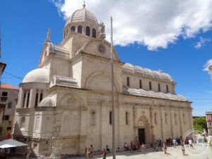
Cathedral of St James at Šibenik (1431–1535): the Cathedral of Stone Alone (Šibenik, Croatia) – Virtual Tour 360°
Un'impresa senza pari: la cattedrale di San Giacomo fu costruita interamente in pietra, senza mattoni né legno, incastrando lastre e blocchi come in un…

Fortifications of Kotor
Medieval fortifications synthesizing Illyrian, Byzantine, Venetian, and Austrian military architecture guard Kotor's dramatic Adriatic harbor town.
Download for tour navigation
🔒 The walk and the notes are open to everyone on this page. The files to take with you — the stop list as a PDF, and the GPX and KML tracks for your phone — come with a CHO account, and the free one includes them.
Walk it with the navigator on
It opens in the Google Maps app with every stop already loaded, in the order we put them in. From there the route is yours: pick how you travel — on foot, by bike, by public transport or by car — change where you start and where you end, drag the stops into a different order, and add places of your own along the way.