

Curated Itinerary
Uvs Nuur Basin: the Closed Steppe Sea
Two stops in Asia’s closed basin: shallow, saline Uvs Lake on the Mongolian side and Russia’s Ubsunur Hollow reserve, from sand dunes to glaciers on one transect.
Take this route into Google Maps
From Uvs Lake to Il Bacino di Uvs Nuur (Ubsunur Hollow) (Russia/Mongolia), in the order we curated them.
➤ Turn on the navigator in Google MapsIt opens in the Google Maps app with every stop already loaded, in the order we put them in. From there the route is yours: pick how you travel — on foot, by bike, by public transport or by car — change where you start and where you end, drag the stops into a different order, and add places of your own along the way.
This itinerary reaches the Uvs Nuur Basin, the closed inland sea Mongolia and Russia have shared on the World Heritage List since 2003. Two stops represent the property’s dozen clusters: Uvs Lake itself — vast, shallow, saline, with no river out — and the Ubsunur Hollow reserve on the Tuvan rim, where the same basin runs from sand dunes to glaciers.
The listing’s logic is compression: every major Eurasian biome — desert, steppe, taiga, tundra — stacked around one terminal lake, with thousands of burial mounds and petroglyphs recording the herding cultures that have worked the transect since Scythian times.
Plan it as an expedition: internal flight to Ulaangom, then 4×4 and ger camps, June to September; the Russian clusters are a separate trip via Kyzyl with permits arranged ahead. The reward is the emptiest horizon on this entire site.
Before you go
A word from your host
This is the wildest itinerary we publish — the kind where the itinerary is really a direction. Give it ten days, expect none of the comforts, and watch the light on the salt lake at dusk do things you will not photograph well. Some horizons are for keeping.
Getting around
Fly Ulaanbaatar–Ulaangom, then 4x4 with driver and ger-camp stays, June–September. The Tuvan clusters are reached separately via Kyzyl with reserve permits; the border between the halves is not a tourist crossing.
Step by step

Uvs Lake
Mongolia's largest lake by area, Uvs is a highly saline body of water remnant from an ancient inland sea, straddling the Mongolian-Russian border at 759…
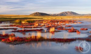
Il Bacino di Uvs Nuur (Ubsunur Hollow) (Russia/Mongolia)
The Uvs Nuur Basin — known in Russian as the Ubsunur Hollow — straddles the border of Russia's Tuva Republic and western Mongolia, forming one of Central…
Download for tour navigation
PDF is the stop list with GPS, to print or keep on the phone. GPX for Garmin / Komoot / OsmAnd. KML for Google Earth and Maps.
Walk it with the navigator on
It opens in the Google Maps app with every stop already loaded, in the order we put them in. From there the route is yours: pick how you travel — on foot, by bike, by public transport or by car — change where you start and where you end, drag the stops into a different order, and add places of your own along the way.
To keep the route in the app instead of opening it once, download the KML above and import it into Google My Maps — Create a new map, then Import: the route then sits among your own maps in Google Maps, with the stops and our notes attached to each one.