
Curated Itinerary
EUR (E42) Rationalist Walk — Three Buildings of the Exposition Quarter
EUR was built for a universal exposition that never opened. Rome began the quarter for 1942; the war cancelled the event and left the buildings, and three of them stand within a two-kilometre walk. The Palazzo della Civiltà Italiana is Italian Rationalism at its most theatrical: a travertine cube of 216 arches, finished in 1943 for an exhibition nobody attended. Gaetano Minnucci’s Palazzo degli Uffici was the first permanent building on the site, raised in under two years as the working headquarters of the exposition itself — the office that built the quarter, inside the quarter. Adalberto Libera’s Palazzo dei Congressi, the winning entry in the 1937 competition, is a forty-five-metre cube wrapped around a single luminous void. Three buildings, three scales of ambition, and a quarter that became a Roman district by accident. Stefano Vigolo tells the full story in a separate article.
Take this route into Google Maps
From Palazzo della Civiltà Italiana – Virtual Tour 360° to Palazzo dei Congressi — EUR by Adalberto Libera, in the order we curated them.
➤ Turn on the navigator in Google MapsIt opens in the Google Maps app with every stop already loaded, in the order we put them in. From there the route is yours: pick how you travel — on foot, by bike, by public transport or by car — change where you start and where you end, drag the stops into a different order, and add places of your own along the way.
Three stops through the monumental core of EUR, the Rome quarter built for the universal exposition of 1942 that the war cancelled: from the Palazzo della Civiltà Italiana to Minnucci’s Palazzo degli Uffici and Libera’s Palazzo dei Congressi. Read the full story in the dedicated article EUR, 1937–1954: Walking the Quarter of the Exposition That Never Opened, by Stefano Vigolo.
Step by step
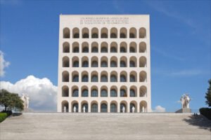
Palazzo della Civiltà Italiana – Virtual Tour 360°
Italian Rationalism at its most theatrical scale: a travertine cube of 216 arches in Rome EUR, finished 1943 for an exposition that never opened.
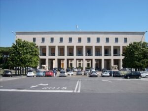
Palazzo degli Uffici (EUR) — Gaetano Minnucci and the First Building of the E42 Quarter
The first permanent building of the EUR quarter, raised in under two years by Gaetano Minnucci as the working headquarters for the exhibition…
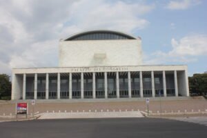
Palazzo dei Congressi — EUR by Adalberto Libera
Adalberto Libera’s winning entry for the 1937 EUR 42 competition is a 45-metre travertine cube wrapped around a single luminous void: an Italian rationalist…
Download for tour navigation
PDF is the stop list with GPS, to print or keep on the phone. GPX for Garmin / Komoot / OsmAnd. KML for Google Earth and Maps.
Walk it with the navigator on
It opens in the Google Maps app with every stop already loaded, in the order we put them in. From there the route is yours: pick how you travel — on foot, by bike, by public transport or by car — change where you start and where you end, drag the stops into a different order, and add places of your own along the way.
To keep the route in the app instead of opening it once, download the KML above and import it into Google My Maps — Create a new map, then Import: the route then sits among your own maps in Google Maps, with the stops and our notes attached to each one.