

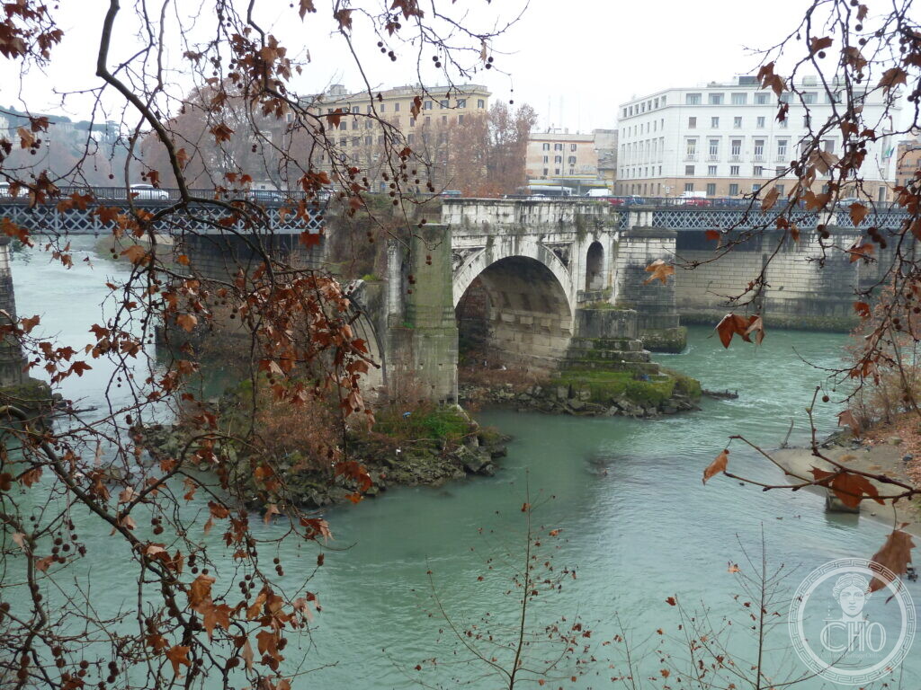
The surviving arch of Rome’s oldest stone bridge, standing in the Tiber near the Tiber Island. It is what remains of the ancient Pons Aemilius, repeatedly damaged by floods and rebuilt across the centuries.
At a glance
The single arch stands just downstream of the Tiber Island, where the river bends and the current runs strongly. The Turismo Roma site describes it as what remains of the ancient Pons Aemilius, made of wood in the 2nd century BC and reconstructed in stone a century later.
Key facts
- Where: Ponte Emilio o Rotto, Lungotevere dei Pierleoni, Roma
- What: Bridge
- When: 142 BC (stone arches, according to Roma Capitale)
- GPS: 41.8894, 12.4795 · Open in Google Maps
History
Roma Capitale records that censors Marcus Aemilius Lepidus and Marcus Fulvius Nobilior built the bridge in 179 BC, initially with a timber structure that probably collapsed. In 142 BC Scipio Africanus and Lucius Mummius made the stone arches. The bridge was composed of six arches, five piers and measured 135 metres. It stood at a bend in the Tiber where the current was very strong, and was damaged from the beginning, especially after severe floods.
In 12 BC, Augustus restored the bridge and it was given the name Maximus. Over the centuries it was damaged and reconstructed several times, taking different names including Pons Senatorum, Lapideus, Maior and Maximus. In 1548 Pope Paul III asked Michelangelo to repair two arches and a pier towards the right bank. The commission was later taken from Michelangelo and given in 1551 to Nanni di Baccio Bigio, who finished the work quickly. Vasari recounts that Michelangelo, crossing the completed bridge with a friend, said: “Giorgio, this bridge trembles under us, let us ride faster so that it does not collapse while we are on it.” The arches restored by Nanni fell a few years later, in the flood of 1557.
Matteo Bartolani di Città di Castello rebuilt the bridge in time for the Jubilee of 1575, under Pope Gregory XIII Boncompagni. He covered it with travertine, rebuilt the fallen arches, strengthened the supporting pier and added dragons in relief, the emblem of the Boncompagni family coat of arms, which remain visible. Around twenty years later, by order of Sixtus V, a branch of the Acqua Felice aqueduct was made to pass over the bridge.
The devastating flood of Christmas Eve 1598 carried away the eastern half of the bridge and made it unusable. Only three of the six arches remained standing, and from then it was called Ponte Rotto. Turismo Roma says the eastern half was destroyed, carrying away three arches and two piers. The remaining section on the right bank became a garden space until the end of the 17th century, after which its poor stability left it entirely out of use. Roma Capitale notes that in 1671 it was rented to leather tanners of the Regola district, who used it for drying hides, and that it later hosted a hanging garden.
In 1853, according to Roma Capitale and Turismo Roma, an iron footbridge was added to link the remaining arches to the banks. Roma Capitale attributes the project to Rodolfo Lanciani and says it was done at the wish of Pius IX. The footbridge was about 63 metres long and used iron cables in a suspension system. After the disastrous flood of 17 metres in 1870, a commission defined works to protect the city. In 1875 Giuseppe Garibaldi presented a bill that allowed the Tiber embankment walls to be considered a work of public interest. The iron footbridge and two arches of the ancient bridge were removed and destroyed, and the present Ponte Palatino was built a little further downstream by architect Angelo Vescovali. Only the opposition of the then Archaeological Commission prevented the destruction of the one remaining arch.
What you see
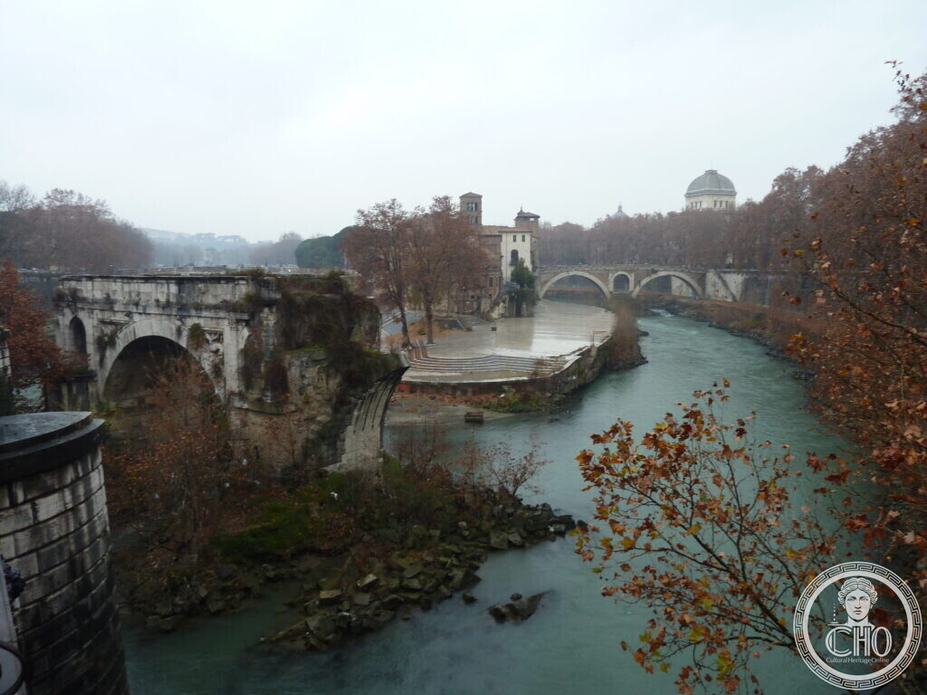
The photographs show the single surviving arch of the bridge, with a large stone arch spanning the green water of the Tiber. In the first photograph, bare tree branches frame the view. The second photograph shows the ruined arch from further away, with a stepped embankment in the foreground and a domed building in the distance under a grey sky. In the upper part of the surviving arch, according to FAI, reliefs of a dragon are still visible, the family emblem of Pope Gregory XIII. The arch has a travertine facing from the 1575 rebuilding, with a tuff and concrete core from earlier restorations, according to Newton Excel Bach.
Do you know more about this place?
If you know a date, a name, a document, a plaque or a photograph that tells its story, write to Sofia through the contact page. What arrives with a source goes into this page, with your name as the contributor.
Nearby
- Ponte Rotto — the Single Arch of the Pons Aemilius, Rome’s First Stone Bri — a page about the same surviving arch
- Temple of Portunus — an ancient temple nearby, later converted into a church
- Temple of Hercules Victor – Virtual Tour 360° — a round temple close to the bridge and the Forum Boarium
- Boarium Forum – Virtual Tour 360° — the ancient market area near the river crossing
- Church of San Giorgio in Velabro – Virtual Tour 360° — a medieval church in the Velabrum, near the Forum Boarium
Gallery
Sources
- Turismo Roma, Pons Aemilius (Ponte Rotto – Broken Bridge): description of the bridge’s history, names, destructions and rebuildings, and the 1853 and 1887 footbridge and demolition works
- Romano Impero, Ponte Emilio – Pons Aemilius: identification of the surviving arch with the Augustan rebuilding of Ponte Emilio, and earlier history of the bridge
- History Hit, Ponte Rotto – History and Facts: dates of the first stone bridge, repairs and major floods
- Roma Capitale, L’ultima arcata: la strana storia di Ponte Rotto: detailed history of construction, collapses, names, rebuilding under Gregory XIII, and modern demolition
- FAI, Ponte Rotto (Ponte Emilio): identification of the surviving arch and the dragon reliefs of Pope Gregory XIII
- Newton Excel Bach, Bridges over the Tiber – 1: dates of construction, stone arches, and the tuff and concrete core of the Augustan restoration
- Stefano Vigolo, photographs and notes to the editorial staff (2026): identification of the subject. Not a published source
Find it on the map
See this place and what’s around it →📷 Become a Cultural Heritage Online photographer
Share your photos of places: they stay published under your name as the author. The more they're seen, the more you get noticed — and soon a contest will reward the most appreciated photos.
Log in or sign up free to add a photo