
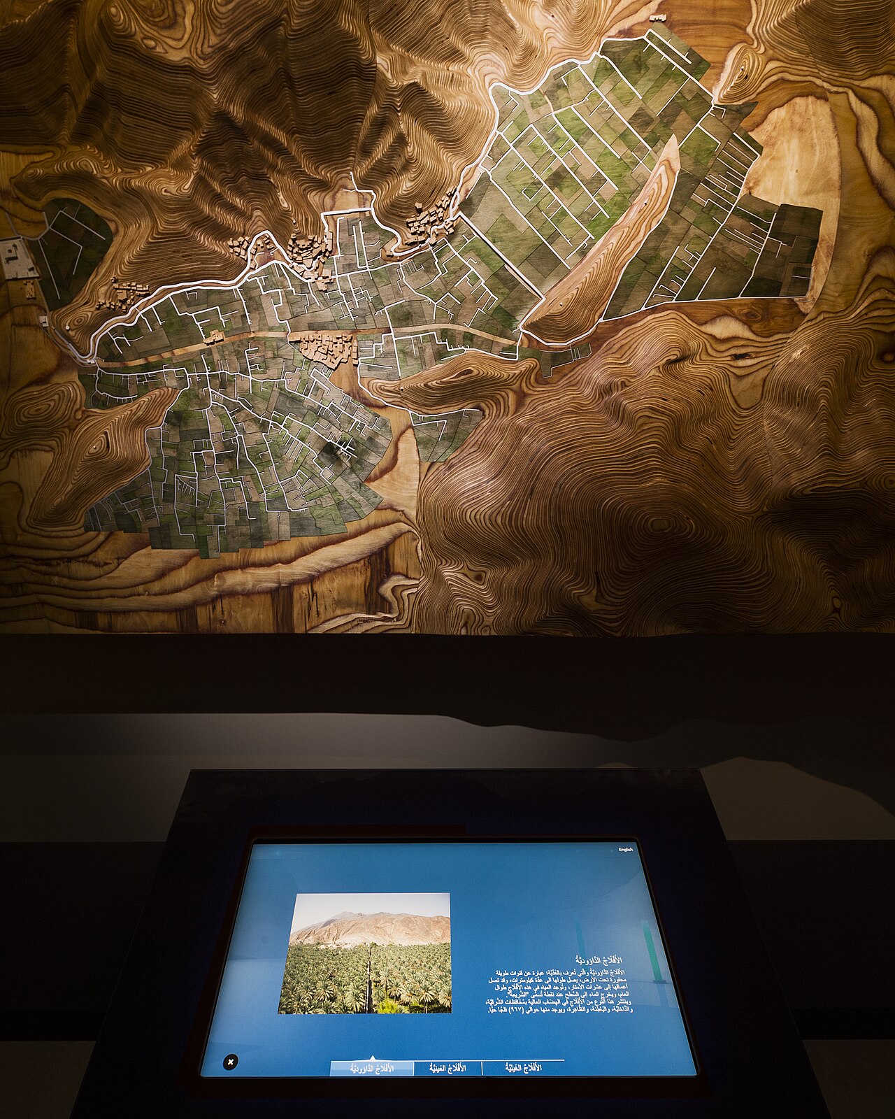
Aflaj Irrigation Systems of Oman (Arabic: “الأفلاج”, “al-Aflaj” — plural of “falaj”, from the South Arabian root meaning “to divide” or “to split”, referring to the distribution of the water among multiple users), inscribed by UNESCO in 2006, is a UNESCO World Heritage designation that recognises five representative examples of the approximately 3,000 traditional underground aqueducts (aflaj — the plural of “falaj”) that irrigate the agricultural settlements of the Sultanate of Oman, as an outstanding example of a living traditional water management system of remarkable antiquity, sophistication, and social organisation that has sustained human settlement in one of the world’s most arid environments for at least 2,500 years. The five inscribed aflaj — selected to represent the range of geographic, technical, and social diversity of the Omani falaj tradition — are: (1) Falaj Daris (in the oasis of Nizwa, the traditional capital of the Omani interior — one of the largest and most copious aflaj in Oman, with a flow of approximately 40 litres per second, serving the date palm gardens and residential areas of Nizwa and documented in medieval Arabic geographical sources); (2) Falaj al-Khatmain (in the village of Birkat al-Mawz in the Wadi Muaydin, approximately 20 km northeast of Nizwa — a smaller falaj serving a traditional date palm oasis at the foot of the Jebel Akhdar, with particularly well-preserved traditional distribution works); (3) Falaj al-Mayassar (in the town of Rustaq in the Batinah region — a historical urban falaj serving the residential areas of the old city of Rustaq, associated with the Rustaq Fort [one of the most important Omani forts]); (4) Falaj Umm al-Arabiyin (in the agricultural area of Al-Hamra in the Wadi Ghul — a smaller agricultural falaj serving the ancient village of Al-Hamra, one of the best-preserved traditional mud-brick settlements of the Omani interior); (5) Falaj al-Jeela (in the coast village of Quriyat, approximately 80 km southeast of Muscat — a coastal falaj serving a small agricultural oasis on the Gulf of Oman coast, demonstrating the application of the falaj technology to coastal as well as interior settings). The inscribed property is not a contiguous site but a thematic serial nomination representing the full range of the Omani falaj tradition.
The engineering and social organisation of the Omani aflaj Falaj Daris · Nizwa Fort · Birkat al-Mawz · Muscat 160 km · Falaj Al-Khatmain
The engineering principle of the Omani falaj (the underground aqueduct system that collects mountain groundwater and delivers it by gravity to agricultural areas) is one of the most elegant solutions to the fundamental water supply challenge of arid mountain environments — a solution that was developed independently in Oman, Iran, Afghanistan, North Africa, and other arid regions as a local response to the same technical problem, but that in each region developed a distinct cultural, social, and legal tradition around the management of the water. The Omani falaj typically consists of four technical elements: (1) the “mother well” (“al-umm” — the deepest point of the system, excavated into the water-bearing alluvial deposits at the base of the mountain range, where the water table is highest; the mother well is typically 10–50 m deep and 1–2 m in diameter, excavated by hand by specialist “falaj diggers” [“haffar al-aflaj”] using hand tools in the pre-modern period — a dangerous occupation, as the alluvial deposits through which the mother well is typically excavated are unstable and prone to collapse); (2) the underground aqueduct (“al-qanat” or “al-qasaba” — the horizontal tunnel running from the mother well to the surface, at a very slight downward gradient of approximately 1:500 to 1:3000, allowing the water to flow by gravity without pumping; the tunnel is approximately 1.0–1.5 m wide and 1.5–2.0 m high in the Omani tradition, typically unlined in the water-bearing gravel section but lined with cut stone or fired brick in the fine-grained clay and silt sections where collapse risk is highest); (3) the access shafts (“manzahl” — vertical shafts sunk from the surface to the aqueduct tunnel at approximately 30–50 m intervals along the tunnel’s course, used for tunnel inspection, maintenance, and the removal of excavated material; the shafts are capped with stone or brick slabs at surface level and are a distinctive feature of the surface landscape above a falaj route — a visitor who knows what to look for can trace the course of an underground falaj by the line of circular stone-capped shaft openings across the landscape); (4) the surface distribution system (“al-sirij” or “al-mulaqqa” — the surface channel network that distributes the water from the point where the falaj emerges at the surface [the “wajid” — the “mother junction”] to the individual agricultural plots and residential areas of the oasis, including the distribution weirs, settling basins, and water measurement devices used to allocate the water among users). The social organisation of the falaj is as sophisticated as its engineering: every operative falaj is owned collectively by the community it serves, with the water rights divided among the community’s members according to a traditional share system (the “athar” share — a time unit of the water flow, typically measured in minutes or hours, representing the right to divert the entire falaj flow into one’s agricultural plot for a set period before yielding to the next user in the rotation). The water rights (“haqq al-ma'” — “the right of the water”) are a form of real property that can be inherited, sold, or donated independently of the land they irrigate, and are recorded in traditional documents (“al-wathiqa” — the certificate of water rights) that are maintained by the community and are considered legally binding property records. The maintenance of the falaj (the periodic inspection and cleaning of the underground tunnel, the repair of damaged sections, and the clearing of debris from the surface channels) is organised collectively, with each water rights holder contributing labour or cash in proportion to their water share — the collective maintenance obligation is enforced by social norms and, historically, by the authority of the falaj’s “wakil” (the elected manager or guardian of the falaj, responsible for coordinating maintenance and adjudicating disputes over water rights).
Practical information
The most accessible of the five inscribed aflaj is Falaj Daris in Nizwa (approximately 160 km south of Muscat by highway) — the falaj can be seen emerging from the ground at a small pool in the Nizwa gardens area, and the surface distribution channels run through the palm garden and residential areas of the old Nizwa settlement adjacent to Nizwa Fort (one of the most impressive Omani forts, extensively restored and open to visitors). Falaj al-Khatmain in Birkat al-Mawz (approximately 20 km northeast of Nizwa on the road to Jebel Akhdar) is particularly picturesque, running alongside the ruins of the historic palace of Imam Bilarab ibn Sultan Al Ya’arubi (17th century CE) and through the ancient date palm gardens of the village. The Aflaj Interpretation Centre is located at Falaj Daris in Nizwa (opens during normal business hours; admission charge). Best visiting season: October–March (the Omani interior is extremely hot in summer; the falaj channels and palm gardens are most pleasant in the cooler months).
Frequently Asked Questions
How old are the Omani aflaj and what archaeological evidence confirms their antiquity?
The antiquity of the Omani falaj system is documented by a combination of archaeological, textual, and hydrological evidence that together confirm a history of at least 2,500 years and possibly considerably longer. The earliest clear archaeological evidence for falaj-type underground aqueducts in Oman comes from the Iron Age sites of the 1st millennium BCE: radiocarbon dating of organic material from the construction phases of several Omani aflaj has produced dates in the range of 1000–500 BCE, consistent with the general Iron Age date assigned to the falaj technology in the Arabian Peninsula by most scholars. This dating aligns with the broader distribution of qanat technology in the ancient Near East: the qanat (the Persian/Iranian form of the same technology as the Omani falaj) is generally accepted to have been invented in northwestern Iran (possibly in the Urartu region of modern Turkey) approximately 1000–700 BCE, based on the earliest archaeological and textual evidence for its use, and the technology appears to have spread from Iran across the Arabian Peninsula and into North Africa and Spain during the 1st millennium BCE through the Achaemenid Persian Empire’s administrative networks and the Arabian trade routes. The textual evidence for the antiquity of the Omani aflaj includes the references in the classical Arabic geographical sources of the 9th–10th century CE (the works of al-Hamdani [c.893–945 CE], al-Istakhri [c.934 CE], and Ibn Hawqal [c.977 CE] all describe the aflaj of the Omani interior as ancient and well-established water management systems, using terminology that implies their existence long before the Islamic period) and the medieval Omani legal texts of the Ibadi scholarly tradition (which contain extensive jurisprudence on falaj water rights, indicating that the system was already sufficiently old and complex by the 9th century CE to have generated a sophisticated legal tradition for resolving disputes). The hydrological evidence is indirect but suggestive: the calculations of the groundwater recharge rate in the Hajar mountain alluvial aquifers, combined with the estimated flow rates of the major Omani aflaj and the depletion of these aquifers under modern pumping, suggest that the aflaj were drawing on groundwater reserves accumulated over millennia of geological time — a hydrological pattern consistent with the aflaj tapping aquifers that had been accumulating since the wetter climatic periods of the Early and Middle Holocene (approximately 10,000–5,000 BCE), when the Arabian Peninsula received significantly more rainfall than today. The largest Omani aflaj — including Falaj Daris in Nizwa, with a flow of approximately 40 litres per second — are tapping very deep groundwater reserves (depths of several hundred meters in some cases), implying a long history of continuous use and suggesting that the falaj builders of the Iron Age and early Islamic period were successfully extracting groundwater from deep aquifers that had been accumulating since the pluvial periods of the Holocene climatic optimum.
What is the legal status of falaj water rights in modern Oman and how does the traditional system interact with modern water law?
The legal status of falaj water rights in modern Oman represents a particularly interesting case study in the interaction between traditional customary water law and the modern state’s water regulation framework — an interaction that has been managed with considerable care by the Omani government in recognition of both the cultural and historical importance of the falaj tradition and the practical reality that the aflaj continue to be the primary source of agricultural irrigation water for a significant fraction of Oman’s farming communities. The traditional falaj water law (the corpus of Ibadi jurisprudence on water rights that has governed the aflaj for over 1,000 years) is based on the concept of the “haqq al-ma'” — the legally protected “right of the water” — which is treated as a form of real property (immovable property, legally distinct from the land it irrigates and independently heritable, saleable, and mortgageable). The traditional legal system for managing falaj water rights includes: (1) the allocation of water shares (“athar”) among the water rights holders, historically determined at the establishment or renovation of the falaj and recorded in community documents; (2) the rotation schedule (the “dawr” — the cycle of water allocation, typically a weekly or fortnightly rotation in which each rights holder receives the entire falaj flow for their allocated “athar” period before yielding to the next holder); (3) the maintenance obligations (each rights holder is obligated to contribute to falaj maintenance in proportion to their water share, enforced by the traditional legal principle that a rights holder who fails to contribute forfeits their water share for the period of default); (4) the dispute resolution mechanisms (the “wakil al-falaj” [the elected falaj manager] is the first instance for resolving water rights disputes; appeals go to the local Islamic court [the qadi], who applies Ibadi jurisprudence on water rights; the ultimate authority is the traditional Islamic concept of “shura” — consultative decision-making by the community). The Omani Water Resources Act of 2000 CE and its implementing regulations formally recognised the traditional falaj water rights system as legally valid and enforceable under Omani law, establishing the Ministry of Regional Municipalities and Water Resources as the state authority responsible for registering, surveying, and protecting the aflaj while preserving the traditional community management structures. The registration of aflaj water rights (a programme begun in the 1990s CE in which the Ministry surveyed all functioning Omani aflaj and registered the traditional water rights in a government database) has provided legal security for the traditional rights holders while enabling the state to better manage the overall groundwater budget of the Hajar mountain aquifers — a critical need given the rapid expansion of modern groundwater pumping for domestic supply and commercial agriculture that, in many areas, is drawing on the same aquifers as the traditional aflaj and threatening to reduce the aflaj flows by lowering the water table below the level of the falaj mother wells.
EXCERPT: Aflaj Irrigation Systems of Oman, UNESCO-inscribed 2006 — five representative underground aqueducts from approximately 3,000 Omani aflaj continuously carrying mountain groundwater to the date palm oases of the Omani interior since at least 1000 BCE: the falaj of Nizwa (Falaj Daris, 40 litres per second) and four others, governed by a traditional time-share water rights system of extraordinary sophistication still operating today.
META: UNESCO World Heritage Sites near Aflaj Irrigation Systems Oman: Bahla Fort Oman (UNESCO 1987), Bat Al-Khutm Al-Ayn Oman (UNESCO 1988), Land of Frankincense Oman (UNESCO 2000), Ancient Qalhat Oman (UNESCO 2018) — Aflaj Irrigation Oman UNESCO 2006, falaj underground aqueduct traditional water management, Falaj Daris Nizwa date palm oasis, qanat falaj Iron Age antiquity, Omani water rights haqq al-ma’ customary law, Jebel Akhdar Hajar mountain groundwater.
Sources
- S1 — UNESCO World Heritage Centre — Aflaj Irrigation Systems of Oman (Ref. 1207) — https://web.archive.org/web/20230601000000/https://whc.unesco.org/en/list/1207/
- S2 — Ministry of Heritage and Tourism Sultanate of Oman — https://mht.gov.om/
Spotted an error? Write to [email protected] and we correct it the same day.