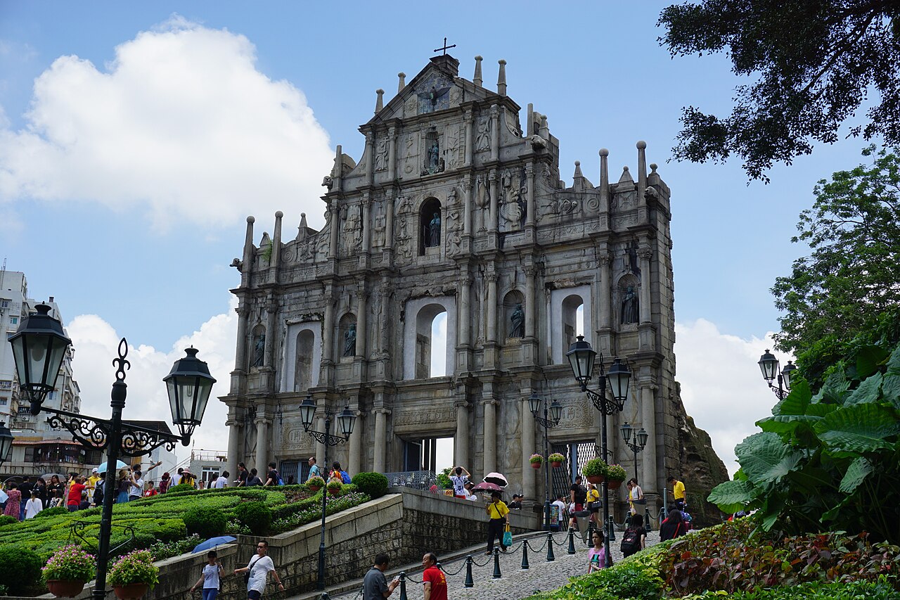
The Historic Centre of Macao, inscribed by UNESCO in 2005, is the best-preserved example of Portuguese colonial architecture in East Asia and one of the oldest points of sustained cultural exchange between Europe and China: 22 listed historic buildings and spaces — churches, temples, fortresses, civic squares, and residential terraces — distributed across the Macao Peninsula, a 12.6-square-kilometre territory at the mouth of the Pearl River Delta that served as the primary Portuguese trading entrepôt in East Asia from 1557 until 1999, when Macao’s sovereignty was transferred to China. The Historic Centre’s Outstanding Universal Value rests on the physical evidence of 442 years of Portuguese-Chinese cultural exchange visible in the single urban fabric of its historic core: a Baroque cathedral facade overlooking a wave-pattern cobblestone square surrounded by Ming-dynasty temples, a Jesuit church built by Chinese craftsmen using southern Chinese construction techniques to execute Western Renaissance architectural designs, and a Mandarin’s house whose Cantonese courtyard architecture incorporates Portuguese decorative tile panels (azulejos) in its interior rooms — a material record of the cultural exchange through which Macao’s Macanese community (descendants of Portuguese-Chinese, Portuguese-Indian, and Portuguese-African mixed-heritage families) created the first genuinely Sino-European urban culture in history.
The Pearl River Delta and the Gateway of China Hong Kong · Zhuhai · Guangzhou — 40 to 140 km by ferry, high-speed rail, and bridge
Sixty Kilometres northeast of Macao by sea (approximately 1 hour by high-speed ferry to Hong Kong Island) or by road via the 55-kilometre Hong Kong-Zhuhai-Macao Bridge (HKZMB, opened 2018, approximately 45 minutes by shuttle bus to the Hong Kong boundary crossing facility), Hong Kong is the primary regional gateway and the site of the Urban Council’s formal recognition in 1997 that Macao’s historic centre was of world significance — a recognition that preceded the Portuguese government’s 2005 UNESCO nomination by eight years. The Hong Kong and Macao historic urban cores are related not by architectural style but by their shared function as the twin gateways through which Western commercial culture entered southern China: Hong Kong as the British entrepôt (after 1841), Macao as the Portuguese predecessor (after 1557). Hong Kong’s Victoria Harbour waterfront contains the former Central Police Station Compound (Hollywood Road, British colonial, 1864–1925, now revitalised as Tai Kwun Centre for Heritage and Arts), the Western Market (1906, Edwardian commercial, now heritage shopping precinct), and the Pawn (Johnston Road, 1888 five-storey pre-war shophouse terrace), all within the area of the proposed Hong Kong Central and Western District historical zone that is on China’s Tentative List for UNESCO nomination. Hong Kong is accessible from Macao by the HKZMB shuttle bus to the Hong Kong Boundary Crossing Facility and then the A11 bus or ferry to Central; or by high-speed ferry from the Macao Outer Harbour or the Macao Cotai Ferry Terminal (approximately 55 minutes–1 hour). The Guangzhou-Shenzhen-Hong Kong Express Rail Link (XRL, opened 2018) connects Hong Kong West Kowloon Station to Guangzhou South in approximately 50 minutes, extending the historic Delta circuit to Guangzhou.
Forty Kilometres north of Macao by road (approximately 30 minutes via the Lotus Bridge crossing from Cotai to Hengqin Island, then the Zhuhai urban road network), Zhuhai City is the mainland Chinese municipality directly adjacent to the Macao peninsula and Cotai Strip. Zhuhai contains no UNESCO-inscribed sites but hosts the start of the HKZMB and the Zhuhai artificial island crossing facilities; it is also the Chinese city through which all land-crossing traffic between Macao and mainland China passes at the Gongbei Port of Entry — the busiest land crossing in the world by passenger volume in pre-pandemic years. From Zhuhai, the Guangzhou-Zhuhai Intercity Railway (MTR-operated, opened 2011) connects Zhuhai Station to Guangzhou South in approximately 75 minutes, with interchange at Guangzhou South for the national HSR network — making Zhuhai-Guangzhou-Guilin (South China Karst, 1997) or Zhuhai-Guangzhou-Kaiping (Kaiping Diaolou, 2007) logical day extensions from the Macao historic circuit. Most Macao-based visitors access Guangzhou by coach (approximately 1.5–2 hours on the expressway) from the Zhuhai Gongbei crossing rather than by rail.
One Hundred and Forty Kilometres north of Macao by road via Zhuhai and the Pearl River Delta expressways (approximately 2 hours by coach or taxi from the Gongbei crossing), Guangzhou (Canton) is the historic capital of Guangdong Province and the city whose commercial role the Portuguese were seeking to access when they established their Macao trading post in 1557. The Portuguese Crown’s 1554 capitulation to the Chinese imperial authorities’ demand that Portuguese traders be confined to Macao rather than establishing a factory in Guangzhou itself directly shaped the urban geography of the Historic Centre: Macao’s Lilau Square, the Barra area (the oldest Portuguese settlement on the peninsula, centred on the A-Ma Temple at the peninsula’s southern tip), and the Rua das Estalagens residential district all developed as responses to the Portuguese community’s need to establish a permanent settlement at the trading intermediary point. From Guangzhou, Macao is most easily reached by the cross-boundary coaches from the Guangzhou Tianhe Coach Station to the Macao Outer Harbour Ferry Terminal (approximately 2.5 hours) or by coach to Gongbei crossing and then taxi or bus to the Macao historic centre. The Guangzhou South HSR station connects to Beijing West (approximately 8 hours), Shanghai Hongqiao (approximately 3.5 hours), and Guilin North (approximately 2 hours) on the national HSR network.
Within Macao itself, the Historic Centre’s 22 listed buildings and spaces form a compact walking circuit of approximately 3 kilometres linking the Barra area (A-Ma Temple, Maritime Museum, Moorish Barracks) south through the Lilau residential quarter, past the Mandarin’s House courtyard complex, up to the Leal Senado square and the Cathedral, north to the Ruins of St Paul’s and the Monte Fort, then east to the Old Protestant Cemetery and the Lou Kau Mansion. The full circuit takes approximately 3–4 hours at a pace that allows adequate time at each monument. All listed monuments in the Historic Centre are free to enter (exteriors and grounds; some interior museums charge admission). The Ruins of St Paul’s (Ruínas de São Paulo, 1602–1640, the baroque stone facade of the Jesuit College of the Mother of God, reduced by fire in 1835 to the four-storey carved facade and its staircase entrance) is the best-known monument and tends to be crowded; the Mandarin’s House (Casa do Mandarim, 1869, the largest traditional residence complex in Macao, built for Zheng Guanying, reformist Qing thinker and author) and the Lou Kau Mansion (1889, Cantonese vernacular with Portuguese azulejo panels) receive fewer visitors and provide a more measured experience of the Sino-Portuguese domestic interior.
The South China Sea trade network and the colonial Pearl River circuit Kaiping Diaolou Guangdong · South China Karst Guilin · Fujian Tulou — 140 to 450 km
One Hundred and Forty Kilometres northwest of Macao by road (approximately 2.5 hours from the Gongbei crossing via the Guangzhou-Zhuhai Expressway north, then the Kaiping section of the Guangdong provincial road network), the Kaiping Diaolou and Villages (inscribed 2007) represent the other major case in the Pearl River Delta where the encounter between Chinese and foreign building traditions produced a distinctive hybrid architectural form. Where Macao’s Sino-Portuguese architecture is the product of official imperial Portuguese colonialism in a single Chinese city, the Kaiping Diaolou are the product of individual Cantonese overseas emigrant communities — families from Kaiping County whose members emigrated to Southeast Asia, North America, and Australia from the 1840s through 1920s and returned with foreign earnings to build defensive watchtower (diaolou) residential complexes whose upper floors are styled in Baroque, Venetian, Italian Renaissance, Moorish, Byzantine, classical Chinese, and Southwestern American architectural vocabularies simultaneously. The 1,833 surviving Kaiping Diaolou (concentrated in the Zili, Majianglong, Jinjiangli, and Sanmenli village clusters) represent the same phenomenon documented in Macao’s historic centre — the physical evidence of Chinese-Western cultural exchange — but from the perspective of the emigrant Chinese community building their reception of Western architectural forms onto a Chinese vernacular base, rather than from the perspective of the Portuguese colonial administration building a Western settlement on Chinese territory. From Macao, Kaiping is reached by coach from Gongbei to Guangzhou (approximately 1.5 hours), then coach from Guangzhou to Kaiping (approximately 1.5 hours).
Four Hundred and Fifty Kilometres north of Macao by high-speed rail (approximately 2 hours from Guangzhou South to Guilin North on the Guiyang-Guangzhou HSR, opened 2014), the South China Karst (inscribed 2007, extended 2014) includes the Shilin Stone Forest component (90 km southeast of Kunming), the Libo Karst component (Guizhou Province), and the Guilin Karst component (Guangxi Autonomous Region) — the last being the most directly accessible from the Pearl River Delta and Macao circuit. The Guilin karst landscape (the iconic “mountains-and-water” imagery of the Li River, 83-kilometre gorge section from Guilin to Yangshuo) is the archetype of the classical Chinese literati landscape painting tradition, particularly the “mountains-and-water” (shanshui) genre that dominated Chinese art from the Tang through Qing dynasties. The karst formations’ verticality — which creates the characteristic “chopstick” profile of individual limestone towers rising 200–500 metres from flat river valleys — is produced by the same chemical process (carbonate rock dissolution by slightly acidic rainfall) that creates the stone forest landscape, but at a different geological timescale and tectonic setting: the Guilin karst formed under tropical conditions during the Cretaceous and Paleogene periods when the area lay at lower latitudes, then was uplifted by Himalayan tectonics to its current position. From Guilin North HSR Station, the Li River cruise (Guilin City Pier to Yangshuo, approximately 4 hours) is the standard experience; Yangshuo is a convenient cycling base for the West Street heritage quarter and the Xingping karst village on the Li River.
Four Hundred Kilometres northeast of Macao by road and coach (approximately 5 hours from Gongbei via the Guangdong-Fujian expressway to Yongding or Nanjing County in Fujian Province), the Fujian Tulou (inscribed 2008) represent yet another manifestation of the Hakka and southern Chinese architectural response to the insecurity of frontier settlement — the circular and square earthen communal fortress structures (tulou, “earthen buildings”) built by Hakka and Minnan Chinese communities in the mountain valleys of western Fujian Province from the 12th through 20th centuries. The 46 inscribed Fujian Tulou — primarily in the Chuxi, Tianluokeng, and Hekeng tulou cluster areas — represent communal residential compounds housing 100–500 residents in ring-shaped structures 3–6 storeys high, with a single entrance gate, interior courtyard, and the entire complex’s exterior wall presenting a nearly featureless rammed-earth surface of 1–2 metres thickness that served as the defensive perimeter of what was effectively a walled village in a single building. The Fujian Tulou are geographically and culturally distant from Macao’s Sino-Portuguese baroque — they represent the Han Chinese frontier community’s response to insecurity rather than the colonial gateway’s response to cross-cultural trade — but both are on the UNESCO list as evidence of architectural solutions to the specific challenges of the Chinese South Coast’s maritime and frontier cultural ecology. From Macao, Fujian Tulou is most efficiently accessed via Xiamen Airport (flights from Macao International Airport, approximately 1 hour) and then coach to the Yongding tulou clusters (approximately 2 hours from Xiamen).
Practical information
The Historic Centre of Macao is located on the Macao Peninsula, the oldest inhabited part of what is now the Macao Special Administrative Region (SAR) of China. Entry to Macao from Hong Kong, mainland China, or international destinations requires a valid passport; most nationalities receive visa-free access for 30–90 days. Macao International Airport (MFM) serves direct flights from major Asian cities; most visitors from Europe and North America use the Macao-Hong Kong ferry (regular high-speed ferry services from Hong Kong’s Outer Harbour and Skypier, approximately 55 minutes) or cross via the HKZMB shuttle bus system. The Pataca (MOP, pegged to HKD at 1.03:1) is the official currency; Hong Kong Dollars are universally accepted at a 1:1 rate throughout the Historic Centre. The Historic Centre’s 22 listed monuments are all accessible on foot within the 3-kilometre circuit of the Macao Peninsula’s historic core; flat shoes are recommended for the wave-pattern cobblestone (calcada portuguesa) surfaces on the principal squares. The best visiting time is October–December (cooler, less humid, less rain than the summer typhoon season June–September); May and June bring the highest humidity. Hotel accommodation ranges from the Historic Centre’s boutique Pousada de São Tiago (within the 16th-century Barra fortress walls) to the Cotai Strip’s casino-resort hotels (a short bus or taxi ride from the historic core). The UNESCO designation covers the historic core, not the Cotai gaming district.
Frequently Asked Questions
How did the Portuguese establish a permanent settlement in Macao in 1557 and why was Macao allowed to exist as a European colony within the Chinese imperial system?
The Portuguese presence in Macao was established not by conquest or treaty but by a series of informal arrangements between Portuguese merchants and local Cantonese officials that gradually solidified over the period 1513–1557 into a de facto settlement tolerated by the Ming dynasty imperial authorities. The Portuguese first encountered the Pearl River Delta in 1513, when Jorge Álvares erected a padrão (stone pillar claiming territory for the Portuguese Crown) on a small island now called Lintin. The initial Portuguese trading in the Pearl River Delta was conducted through the existing Chinese maritime trade system — the Portuguese merchants paid duties to Cantonese customs officials and traded at the designated markets near Guangzhou — but by the 1550s, the Portuguese had begun to establish a seasonal trading base at the Macao Peninsula, at the mouth of the Pearl River Delta, rather than at the official trading markets further upriver. The local Cantonese magistrates tolerated the Portuguese presence at Macao partly because the Portuguese paid rent (a land rent of 500 taels per year to the Guangdong provincial government, later formalised and paid until 1849) and partly because the Portuguese were useful as intermediaries in the China-Japan trade: direct Ming Chinese trade with Japan was prohibited by the Jiajing Emperor’s 1547 maritime trade ban (haijin), but Portuguese merchants could legally carry Chinese goods to Japan and Japanese silver to China, generating tax revenue for Cantonese officials at Macao’s customs houses. The Portuguese settlement was formalised in 1576 when Pope Gregory XIII established the Diocese of Macau, creating a permanent ecclesiastical institution that anchored the Catholic Church’s East Asian mission at Macao; and in 1586 when the Portuguese Crown established a city government (câmara, the Leal Senado building preserves this institution). The Ming dynasty never formally ceded sovereignty over Macao to Portugal — the Chinese position was always that Macao was Chinese territory on which Portuguese merchants were permitted to reside and trade — and this position was maintained until the 1887 Protocol of Lisbon, the first formal treaty between Portugal and China, which acknowledged Portugal’s right to “perpetual occupation and governance” of Macao.
What is the Macanese community and how does it differ from the Portuguese and Chinese populations of Macao?
The Macanese (Macaenses in Portuguese) are the Eurasian mixed-heritage community that developed in Macao over the period 1557–1999 through intermarriage between Portuguese men and women of Cantonese, Indian (Goa, Malacca), African (Mozambique, Cape Verde), Japanese, Malay, and Filipino heritage. The Macanese community is culturally distinct from both the local Cantonese Chinese population (who maintained their own Chinese community institutions, temples, and clans while living in administrative and commercial proximity to the Portuguese settlement) and from the Portuguese-born Portuguese (who typically served short administrative terms and returned to Portugal or other Portuguese colonies). The Macanese are most accurately described as a creole community — a community that developed a distinct culture (including the Patuá or Macanese Creole language, a Portuguese-based creole with Cantonese, Malay, English, and Spanish elements; a distinctive cuisine mixing Cantonese, Portuguese, and Southeast Asian ingredients; and specific domestic architectural traditions visible in the Mandarin’s House and the Patane residential quarter) through generations of living at the intersection of Chinese and Portuguese culture. The Patuá language (now spoken by fewer than 50 people, primarily elderly Macanese living in Macao, Portugal, or the Macanese diaspora in Brazil, San Francisco, and Hong Kong) is the most distinctive marker of the Macanese identity: it is the primary evidence that the community maintained a distinct linguistic tradition separate from both Portuguese and Cantonese for more than 300 years. The 2005 UNESCO inscription explicitly recognises the Macanese community’s culture as one of the Outstanding Universal Values that the Historic Centre’s architecture documents — the Mandarin’s House, with its Cantonese courtyard plan and Portuguese azulejo tile panels, is the most precise physical evidence of how Macanese domestic culture integrated both traditions.
What happened to the Jesuit College of the Mother of God (the Ruins of St Paul’s) and why is a single stone facade one of the most recognised heritage sites in East Asia?
The College of the Mother of God (Colégio da Madre de Deus) was built between 1602 and 1640 by the Society of Jesus (Jesuits) as their primary East Asian educational and missionary base, attached to the Church of St Paul (Igreja de São Paulo). The college functioned as the first Western-style university in East Asia — Giovanni Battista Rossi, Matteo Ricci, and Alessandro Valignano all worked at Macao’s Jesuit institution before proceeding to their Chinese mainland missions — and attracted Japanese Christian refugees (expelled from Japan after the Shimabara Rebellion’s suppression in 1637–1638) who helped build the church’s facade under the direction of the Italian Jesuit Carlo Spinola and his Japanese craftsmen. The church facade — which is what the Ruins of St Paul’s preserves — is a five-tiered carved stone screen in a Baroque-Asian hybrid style that combines Renaissance-Mannerist architectural vocabulary (Corinthian pilasters, triangular pediment, bas-relief narrative panels) with East Asian iconographic content (a Japanese chrysanthemum, Chinese dragons flanking the Virgin Mary, a demon trampled underfoot below a Death’s Head) that the Japanese craftsmen introduced into the European decorative programme. The college and church were destroyed by fire in August 1835, during a typhoon and domestic fire that swept the college complex — the stone facade survived because it was built from granite, while the timber-framed interior was completely consumed. The fire left the facade standing in isolation, which was its state when 19th-century European and American visitors began to photograph and draw it — the isolated stone facade against the sky, with the hill and the surrounding Cantonese neighbourhood visible behind it, became the defining visual image of Macao as a place where Western and Eastern cultures had co-existed for centuries. The Monte Fort (Fortaleza do Monte, 1617, the military fortress adjacent to the college ruins) survived intact and now houses the Macao Museum — the most comprehensive resource on the Macao Historic Centre’s history and the material culture of the Macanese community.
Sources
- S1 — UNESCO World Heritage Centre — Historic Centre of Macao (Ref. 1110) — https://web.archive.org/web/20230601000000/https://whc.unesco.org/en/list/1110/
- S2 — UNESCO World Heritage Centre — Statement of Outstanding Universal Value (Ref. 1110) — https://whc.unesco.org/en/list/1110/
Spotted an error? Write to editorial@culturalheritageonline.com and we correct it the same day.