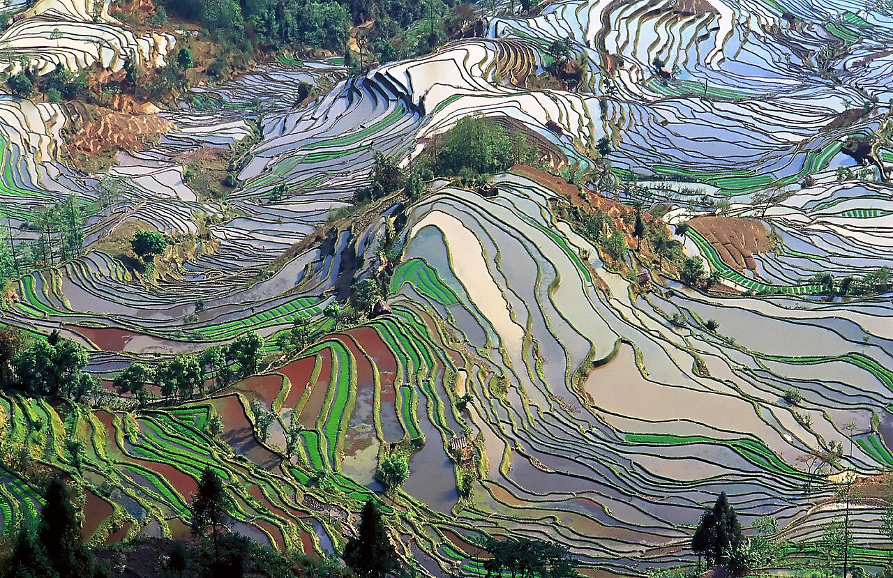
The Cultural Landscape of Honghe Hani Rice Terraces, inscribed as UNESCO World Heritage in 2013, covers 16,603 hectares of irrigated terraces in Yuanyang County, southern Yunnan Province, built on slopes that rise approximately 800 metres from the Red River (Yuanjiang) valley floor at 144 metres elevation to the forest zone above 2,000 metres. The terrace system, developed by the Hani people over approximately 1,300 years since the 7th century CE, is maintained by a four-element hydrological cycle in which forest catchments above the villages supply water through gravity-fed irrigation channels to the terraces below and return to the river via drainage, operating without mechanical pumps. The closest city with railway and bus connections is Mengzi, approximately 100 kilometres northwest, reachable from Kunming in approximately 2 hours by high-speed rail; a further 1–2 hours by road connects Mengzi to the Yuanyang terrace villages.
Yunnan Province connections: South China Karst Shilin and Old Town of Lijiang South China Karst Shilin Stone Forest 300 km west of Yuanyang / 3h road via Kunming; Old Town of Lijiang 450 km northwest / 5h road from Yuanyang or 2.5h from Kunming by HSR then 1h bus
The South China Karst, inscribed as UNESCO World Heritage in 2007 and extended in 2014, covers seven clusters of karst formations across four provinces (Yunnan, Guizhou, Guangxi and Chongqing). The Shilin (Stone Forest) component in Shilin Yi Autonomous County is approximately 300 kilometres west-northwest of the Hani Rice Terraces and reachable in approximately 3 hours by road from Yuanyang via the Yuxi–Yuanyang Expressway to Kunming (approximately 2.5 hours), then by expressway east to Shilin (approximately 1 further hour). The Shilin component covers 350 square kilometres of pinnacle karst terrain in which grey limestone columns, sculpted by dissolution since the Permian period (approximately 270 million years ago), rise 2 to 40 metres above a karstic plain at approximately 1,700 metres elevation. The characteristic pinnacle form of Shilin karst develops through a different mechanism from the tower karst of Guilin (which is also part of the South China Karst inscription, in Guangxi): Shilin’s near-vertical pinnacles are the result of deep dissolution in a structurally jointed horizontal limestone plateau where the joint planes provide pathways for acidic groundwater to dissolve the rock in vertical corridors, leaving resistant columns between the dissolved joints. The Yi people (Sani branch), who have inhabited the Shilin area for approximately 600 years, hold the Ashima festival at Shilin each year during the Torch Festival (24th of the 6th lunar month, typically late July to early August), featuring the Ashima dance, the Yi traditional costume and the music of the sanxian (three-stringed plucked lute). The inscribed area of the Shilin component includes both the Greater Stone Forest (Da Shilin, 12 sq km, the primary visitor area) and the Lesser Stone Forest (Xiao Shilin, 1 sq km), as well as the Naigu Stone Forest (Naigu Shilin, 8 sq km, a darker basalt-capped karst area less visited than the main limestone areas). The contrast with the Hani Rice Terraces is between a purely geological inscription (Shilin’s Outstanding Universal Value rests entirely on natural karst geomorphology) and a cultural landscape inscription in which the Outstanding Universal Value is the 1,300-year continuous interaction between the Hani people’s agricultural system and the natural slope hydrology of the Red River watershed.
The Old Town of Lijiang, inscribed as UNESCO World Heritage in 1997, is approximately 450 kilometres northwest of the Hani Rice Terraces and reachable by road from Yuanyang in approximately 5 hours (south Yunnan expressway to Kunming, then northwest via Chuxiong to Lijiang), or more efficiently by high-speed rail from Kunming South to Lijiang (approximately 2.5 hours on the Dali–Lijiang railway, opened 2009) then 1 hour from the rail terminus to the Old Town by taxi or bus. The Lijiang inscription covers the historic urban district of Dayan town (the Naxi-language name for the core settlement), an area of approximately 3.8 square kilometres of traditional Naxi residential and commercial architecture arranged around a network of three streams fed by the Black Dragon Pool spring at the base of Elephant Hill (Xiang Shan). The Naxi architecture of Lijiang is a hybrid vernacular: timber-framed courtyard houses of the standard Yunnan type are combined with Naxi-specific decorative elements (carved wooden screens in the courtyard-facing facades, flower and rockery gardens in the inner courtyards) and display stylistic influences from Han Chinese, Tibetan and Bai architectural traditions, reflecting the town’s historic position at the junction of the Ancient Tea Horse Road (Chamagudao) trade routes connecting Yunnan, Sichuan, Tibet and Burma. The Dongba manuscript tradition of the Naxi people — the only pictographic writing system still in active use in the world — is practiced by approximately 100 remaining Dongba (Naxi priests) and has generated a corpus of approximately 20,000 handwritten manuscripts currently held in institutions in China, the United States, Germany and Japan. The shared characteristic between Lijiang and the Hani Rice Terraces is the combination of an ethnic minority agricultural landscape and the inscription’s recognition of a living cultural tradition (Naxi Dongba practice; Hani terrace agriculture and the ahu agricultural calendar) rather than a frozen historical monument.
Southwestern circuits: Three Parallel Rivers of Yunnan and Zuojiang Huashan Rock Art Three Parallel Rivers 600 km northwest of Yuanyang / 8h road via Kunming and Dali; Zuojiang Huashan Rock Art 400 km south / 4h by road into Guangxi across the Yunnan border
The Three Parallel Rivers of Yunnan Protected Areas, inscribed as UNESCO World Heritage in 2003, cover approximately 1,700,000 hectares in northwestern Yunnan, approximately 600 kilometres northwest of the Hani Rice Terraces. The most practical access route from Yuanyang is via Kunming (2.5 hours by road to Kunming, then 3 hours by HSR to Lijiang or 2 hours to Dali, then 2–4 hours by road into the gorge zone) making a combined visit requiring 2–3 additional days. The inscription protects the parallel gorges of the Yangtze (Jinsha), Mekong (Lancang) and Salween (Nu) rivers in a 170-kilometre-wide corridor of northwestern Yunnan where the three rivers flow south in near-parallel valleys separated by mountain ridges exceeding 6,000 metres. The Mekong River (Lancang Jiang) is the most geographically significant link between the Three Parallel Rivers inscription and the Hani Rice Terraces: the Red River (Yuanjiang), which drains the Yuanyang terrace landscape, flows southeast through Vietnam to the Gulf of Tonkin, while the Mekong flows south through Yunnan and then through Myanmar, Laos, Thailand, Cambodia and Vietnam. Both are tributaries of the same regional hydrological system fed by Tibetan Plateau snowmelt, and both drain landscapes where ethnic minority agricultural communities have developed distinctive terrace-farming systems adapted to steep slopes and monsoon hydrology. The Three Parallel Rivers inscription documents exceptional floral biodiversity: the region contains more than 6,000 plant species (approximately 25% of China’s total flora) in a vertical range from subtropical forest at 760 metres to permanent glaciers above 6,000 metres, and is identified as one of the world’s 25 biodiversity hotspots. The Hkakabo Razi mountain on the Myanmar side of the Salween gorge, visible from the Nujiang (Salween) gorge route, is at 5,881 metres the highest peak in Southeast Asia.
The Zuojiang Huashan Rock Art Cultural Landscape, inscribed as UNESCO World Heritage in 2016, covers 38 rock art sites along 105 kilometres of cliff faces above the Zuojiang (Left River) and Mingjiang River in the Guangxi Zhuang Autonomous Region, approximately 400 kilometres south of the Hani Rice Terraces across the Yunnan–Guangxi border. The most direct road route from Yuanyang is via Jianshui and Mengzi south to the Guangxi border, then east to Chongzuo city, the nearest urban centre to the Huashan site (approximately 4 hours total). The Huashan cliff paintings, attributed to the Luoyue people (ancestors of the modern Zhuang ethnic group) and dated to the period 5th century BCE – 2nd century CE by associated archaeological evidence, are painted in red ochre on near-vertical cliff faces above the river, in locations accessible only by boat or by very difficult climbing. The largest single rock art panel, at Huashan (Hua Mountain) in Ningming County, measures 172 metres wide by 44 metres high and contains approximately 1,800 individual human and animal figures, the largest painted rock art panel in the world. The thematic relationship between Huashan and the Hani Rice Terraces is the documentation of agricultural and ritual practices of ethnic minority communities in the mountain borderlands of southern China and northern Southeast Asia over the same historical longue durée: the Luoyue agriculturalists who painted the Huashan cliffs and the Hani farmers who built the Yuanyang terraces both developed landscape-management systems adapted to similar ecological conditions of steep terrain, seasonal monsoon rainfall and river-valley agriculture, separated by 400 kilometres and approximately 1,200 years in the initiation of their respective cultural traditions.
Practical information
The Hani Rice Terraces are distributed across Yuanyang County’s hilly terrain at elevations between 1,400 and 2,000 metres; the main visitor cluster is in Xinjie Township (the county capital), from which four key terrace viewpoints are accessible by road: Duoyishu (sunrise viewpoint facing east, approximately 12 km from Xinjie), Bada (broader panoramic terrace views, approximately 18 km from Xinjie), Laohuzui (Tiger’s Mouth, elevated ridge viewpoint, approximately 22 km from Xinjie) and Mengpin (reflective flooded terraces, approximately 15 km from Xinjie). Local minibuses connect Xinjie to the viewpoints; taxi hire for a full-day circuit of all four is approximately 200–300 CNY. Accommodation is available in Xinjie and in guesthouse clusters adjacent to the Duoyishu and Laohuzui viewpoints; basic accommodation at the viewpoints allows early morning access before day-tripper arrivals. From Kunming, the most practical route is high-speed rail to Mengzi (approximately 2 hours) then bus to Yuanyang/Xinjie (approximately 1.5 hours); alternatively, direct buses from Kunming Nanbu Bus Station to Xinjie take approximately 4.5 hours. The optimal season for flooded-terrace photography (when the terraces are filled with water before transplanting and reflect the sky) is mid-November to early February, when water is held in preparation for the spring planting cycle; midsummer terraces are green with growing rice. Temperatures in the Yuanyang highlands are moderate year-round (15–25°C at the viewpoint elevations) even when the valley floor below is subtropical. Morning fog in the valley is most frequent in winter and spring, creating the layered terrace-and-cloud photographs characteristic of the site.
Frequently Asked Questions
How does the Hani four-element irrigation system work without pumps or mechanical intervention?
The Hani terrace irrigation system operates on a gravity-fed cascade principle that exploits the 800-metre vertical range between the forested catchment zone above 2,000 metres and the lowest terrace fields above the Red River valley. The “four elements” described in the UNESCO inscription are forest, village, terrace and waterway; the spatial organisation of each Hani village on the slope reflects this vertical structure. Forest is maintained above the village zone: the Hani land-management tradition prohibits clearing of forest above the upper irrigation channels, partly for religious reasons (the forest is associated with ancestral spirits and protected trees are not felled) and partly for the practical function of sustaining the sponge capacity of the soil, which releases water steadily through springs and seepage throughout the dry season rather than allowing rapid runoff after rain. The springs and streams emerging from the forest zone feed primary irrigation channels (qu) that are communally maintained by each village under a system of collective labour obligation (both male and female adults contribute annual labour days to channel cleaning and repair). Water from the primary channels is distributed to individual terrace fields through a sharing system regulated by the village council and adjusted by negotiation between households in years of low supply. The terraces themselves function as sequential retention basins: water flows from the highest terrace to the next lower, and so on through the cascade, with each terrace level retaining water for a period determined by the bund height (typically 0.3 to 1.5 metres) before overflowing to the next level. Water that drains off the lowest terrace level returns to the stream system and ultimately to the Red River. The system has no single point of control: it is self-regulating through the slope topography, the forest water retention and the terrace bund heights, requiring human intervention only for bund maintenance, channel clearing and distribution regulation at the community level.
What is the ahu calendar, and how do the Hani people use it to organise agricultural cycles?
The ahu (sometimes romanised as “achu” or transliterated differently from the Hani language) is the traditional Hani agricultural calendar, a system for marking time and organising terrace-farming work based on the observation of natural indicators rather than a fixed numerical calendar system. The calendar identifies seasonal transitions by the combination of bird calls, plant flowering and growth stages, insect emergence, and astronomical observations (star positions, moon phases). Key agricultural events are tied to specific biological indicators: the call of a particular cuckoo species (locally called the “rice planting bird” in Hani) signals the beginning of transplanting; the emergence of a specific beetle marks the time for first application of water to dry terraces; the flowering of a certain wild plant indicates the period for harvesting the winter crop. This phenological (biology-based) calendar system is common across many traditional agricultural societies in monsoon Asia and reflects a sophisticated body of local ecological knowledge accumulated over centuries of observation in a specific microclimate. The ahu calendar differs from the Han Chinese lunar-solar agricultural calendar (the 24 solar terms, or jieqi, standardised in the Han dynasty) in being specific to the local ecology of the Honghe highland zone rather than generalised across China’s diverse climates: the biological indicators used in the ahu calendar are calibrated to the specific altitude, monsoon patterns and local plant communities of the Yuanyang terrace landscape and would not be reliable indicators in other parts of China. The UNESCO inscription explicitly identifies the ahu calendar alongside the terrace-building tradition as part of the Hani’s Outstanding Universal Value, recognising it as part of the intangible cultural heritage embedded in the landscape rather than simply an agricultural technique. The calendar is transmitted orally from elder to younger generations within Hani communities and is most actively practiced in the villages with the greatest concentration of elderly farmers; its transmission has been under pressure from the introduction of standard Han calendar systems in education and public administration since the mid-20th century.
How do the Hani rice terraces compare in age and scale to other major terraced rice landscapes in Asia?
The Honghe Hani Rice Terraces (1,300 years, 16,603 hectares) are one of several major terraced rice systems in East and Southeast Asia that have been recognised or nominated for UNESCO inscription, and comparisons of age and scale require careful attention to what is being measured. The Banaue Rice Terraces in the Cordillera region of the Philippines, of which the Cordillera Ancestral Domain was inscribed as UNESCO World Heritage in 1995, are often cited as 2,000 years old; this figure is based on oral tradition and some archaeological inference, with scientific dating providing a more conservative estimate of approximately 1,000–1,500 years for most surviving terrace construction. The Banaue terraces cover approximately 10,360 hectares across the inscribed property (which includes five terrace clusters); the individual Ifugao family terraces are maintained under a community tenure system comparable in structure (if not in detail) to the Hani system. The Jatiluwih Rice Terraces in Bali, part of the Subak system inscribed as UNESCO World Heritage in 2012 (the Cultural Landscape of Bali Province: the Subak System as a Manifestation of the Tri Hita Karana Philosophy), cover a portion of the estimated 20,000 hectares of Balinese rice terraces maintained under the subak (water temple cooperative) system. The Balinese subak system is documented from the 9th century CE, making it approximately 1,200 years old. The comparable feature across all three systems — Hani, Ifugao and Balinese subak — is the management of sloped terrain for wetland rice cultivation through community governance of water distribution rather than individual property rights over the water resource. The Hani system is distinctive in the UNESCO inscription for the explicit documentation of its vertical zonation (forest-village-terrace-waterway as a complete hydrological unit) as the basis of its Outstanding Universal Value, rather than the terraces alone.
Sources
- S1 — UNESCO World Heritage Centre — Cultural Landscape of Honghe Hani Rice Terraces (Ref. 1111) — https://web.archive.org/web/20230601000000/https://whc.unesco.org/en/list/1111/
- S2 — Honghe Hani Rice Terraces Management Bureau — https://whc.unesco.org/en/list/1111/
- S3 — Seidensticker, John. <em>Riding the Tiger: Tiger Conservation in Human-Dominated Landscapes</em>. Cambridge University Press, 1999. ISBN: 978-0-521-64835-6.
Spotted an error? Write to editorial@culturalheritageonline.com and we correct it the same day.